A Churchill County Map has to do more than locate Fallon. Churchill County stretches across a broad Nevada basin-and-range landscape where U.S. 50 and U.S. 95 meet a dense local road network, the Carson River supports irrigated land and wetlands, and long mountain ranges rise above low desert valleys to the east. The WebP previews on this page are designed for quick viewing, and the same four maps are available below as high-resolution JPG files in one ZIP archive. High-resolution map files are available for download in the section below.
Fallon is the only major city ranked on the supplied city panel, which immediately tells the reader something important about the county. Settlement and services are strongly concentrated in the western Lahontan Valley, while much of the central and eastern county consists of open desert basins, mountain ranges, washes, and widely spaced roads. The water and elevation maps therefore explain Churchill County at least as well as the road map does.
Table of Contents
Fallon at the U.S. 50–U.S. 95 crossroads of the Lahontan Valley
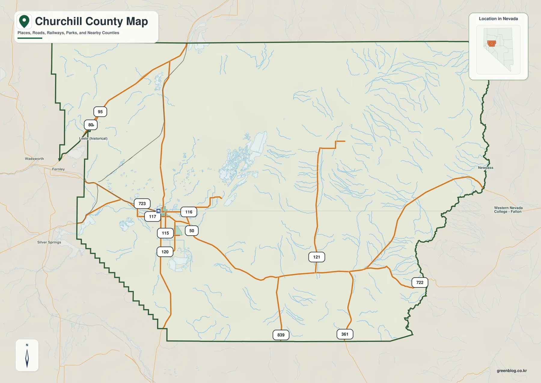
The general county map makes Fallon the obvious transportation anchor. U.S. 50 crosses the city from west to east, while U.S. 95 provides the major north-south route. Nevada routes 115, 116, 117, and 120 cluster around the Fallon area, with 723 on the west side and longer routes such as 121, 722, 361, and 839 extending into the more sparsely settled central and eastern county.
Fernley and Silver Springs appear outside the western boundary as useful regional reference points, while Leete (historical) is labeled near the northwest and Newpass appears near the far eastern edge. Those place names help show how sharply road density changes. Around Fallon, the network is close and interconnected; farther east, individual roads cross long distances between basins and mountain ranges.
Fallon’s central role also has a long administrative and agricultural history. Churchill County’s official master plan states that the county was created in 1861 as one of the original counties of Nevada Territory and that Fallon became the county seat in 1903. Irrigation development, rail connections, and regional mining activity helped turn the community into the county’s main service and farming center.
This static map should not be treated as live navigation for desert roads. Construction, closures, surface conditions, and access can change, especially away from the main highways. It is most useful for seeing where U.S. 50 and U.S. 95 meet, how the local route system spreads around Fallon, and how quickly the road pattern thins toward the interior.
One ranked city in a county dominated by open land
The city-distribution panel is unusually simple. Fallon is the only ranked major city, and no second city appears in the CITY INDEX. The dot sits in the western part of the county within the low Lahontan Valley, while the enormous central and eastern areas contain no comparable urban marker. The graphic therefore works better as a picture of settlement concentration than as a city-to-city comparison.
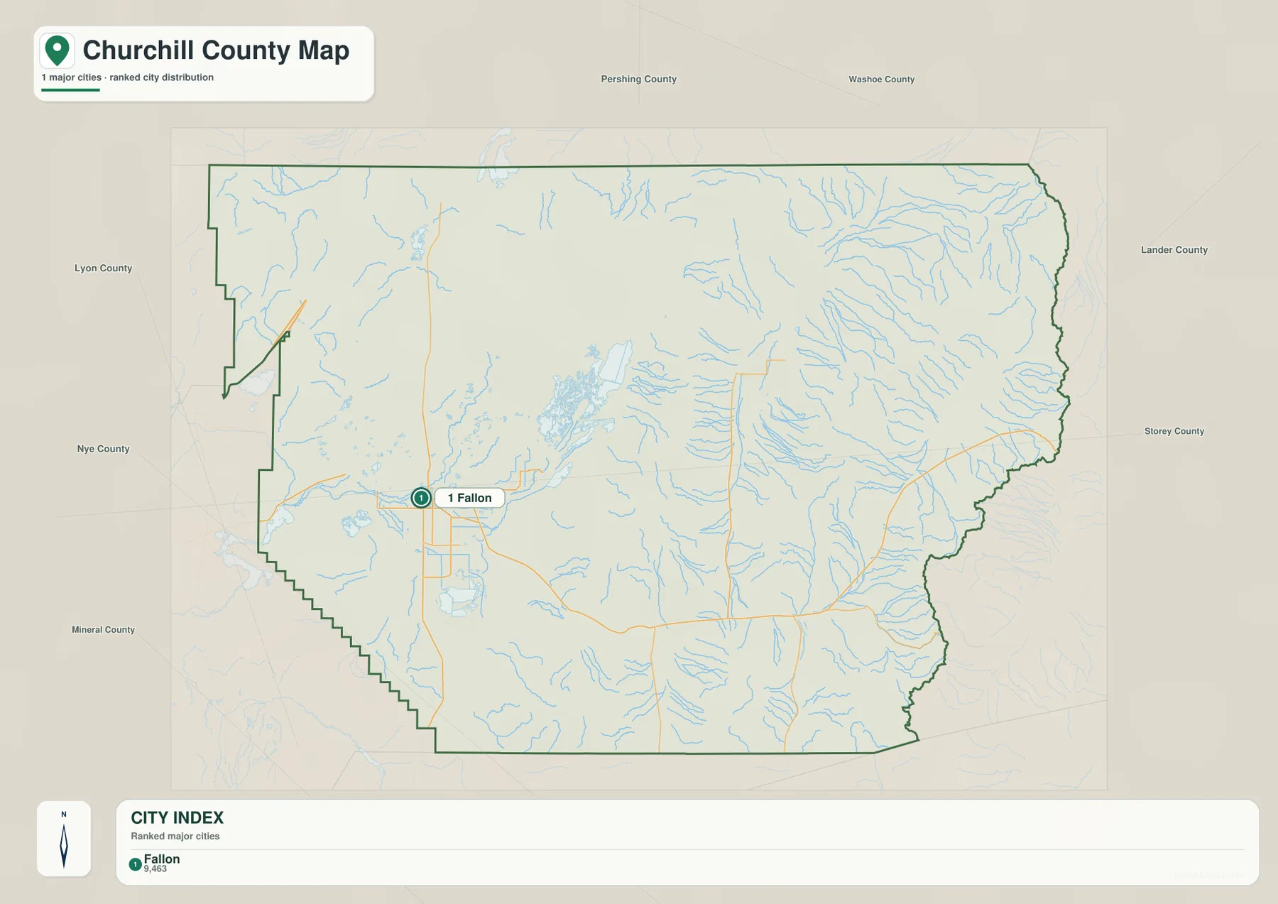
Because the city graphic contains no distance connectors, it should not be used to infer mileage from Fallon to remote landmarks or communities. Anyone who needs driving distance should use current route information instead. The useful point here is that the county’s population pattern is highly uneven: one principal city sits beside irrigated land and wetlands, while broad stretches of desert and mountain terrain remain lightly settled.
The official county history helps explain that pattern. The Newlands Reclamation Project and later completion of Lahontan Dam expanded reliable irrigation in the early twentieth century, allowing farming around Fallon to grow far beyond what the surrounding desert climate would otherwise support. On the maps, the contrast between the water-rich western valley and the drier eastern interior is visible even without population statistics.
Carson River irrigation meets the Stillwater wetland complex
The western water map is centered on the Carson River and South Branch Carson River near Fallon. Sheckler Reservoir and Carson Lake sit nearby, while New River Slough extends toward a larger group of wetlands and managed waters that includes Stillwater Point Reservoir, Dutch Bill Lake, Tule Lake, and Pintail Bay. The concentration of blue features is striking in a county otherwise dominated by arid terrain.
The U.S. Fish and Wildlife Service describes Stillwater National Wildlife Refuge as a large wetland landscape northeast of Fallon that includes fresh and brackish marshes, river corridors, alkaline beaches, desert scrub, sand dunes, and open water. The refuge is especially important to migratory waterfowl and shorebirds. The supplied water map makes it easy to see why: several named lakes, reservoirs, sloughs, and low basins cluster in the same broad valley.
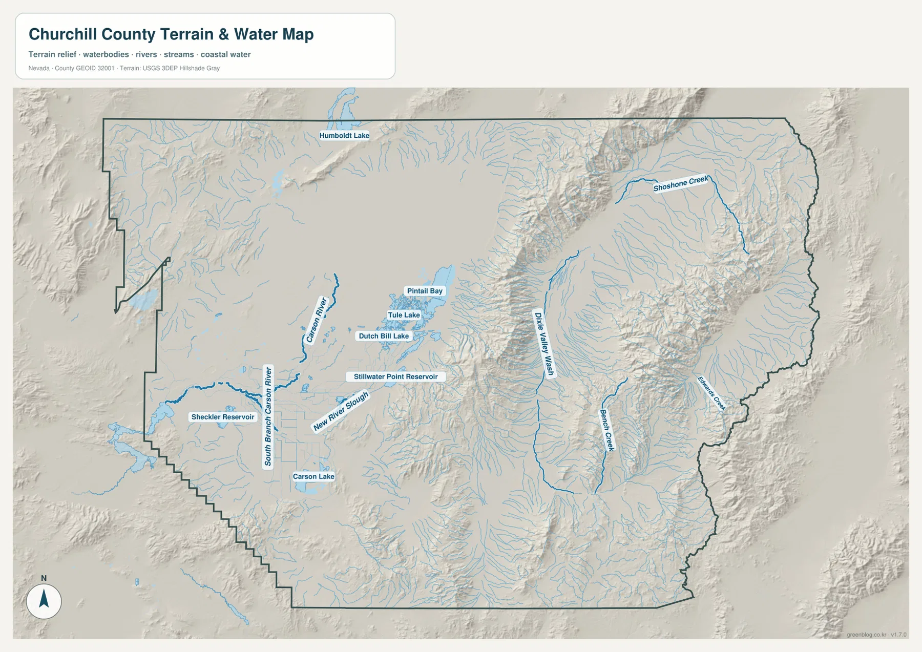
Beyond the western valley, the hydrography changes character. Dixie Valley Wash occupies a long basin in the east-central county, while Bench Creek, Shoshone Creek, and Edwards Creek follow mountain valleys and canyon systems farther east. Humboldt Lake appears near the northern boundary. Instead of a continuous river network, the eastern half contains many short drainages shaped by isolated ranges and closed desert basins.
Blue line width and water color are symbolic and do not measure flow, depth, water quality, or flood hazard. Wetland and reservoir conditions can also vary with season and water management. Use current U.S. Fish and Wildlife Service, Nevada State Parks, USGS, or local agency information for recreation, flood, access, and water-condition decisions.
From 1,030-meter basins to mountain summits above 3,000 meters
The elevation map captures the scale of Churchill County better than any other view. The displayed actual surface ranges from about 1,030 to 3,014 meters, with a mean near 1,442 meters. Fallon and the western-central basins appear in green at relatively low elevation, while long brown mountain ranges rise through the center and along the eastern side.
Traveling east from Fallon, the terrain first remains broad and low before a narrow mountain belt rises sharply from the basin floor. East of that range, Dixie Valley drops again into a long low trough, followed by another major mountain system. This repeated sequence of basin, range, basin, and range is a clear example of Nevada’s Basin and Range topography.
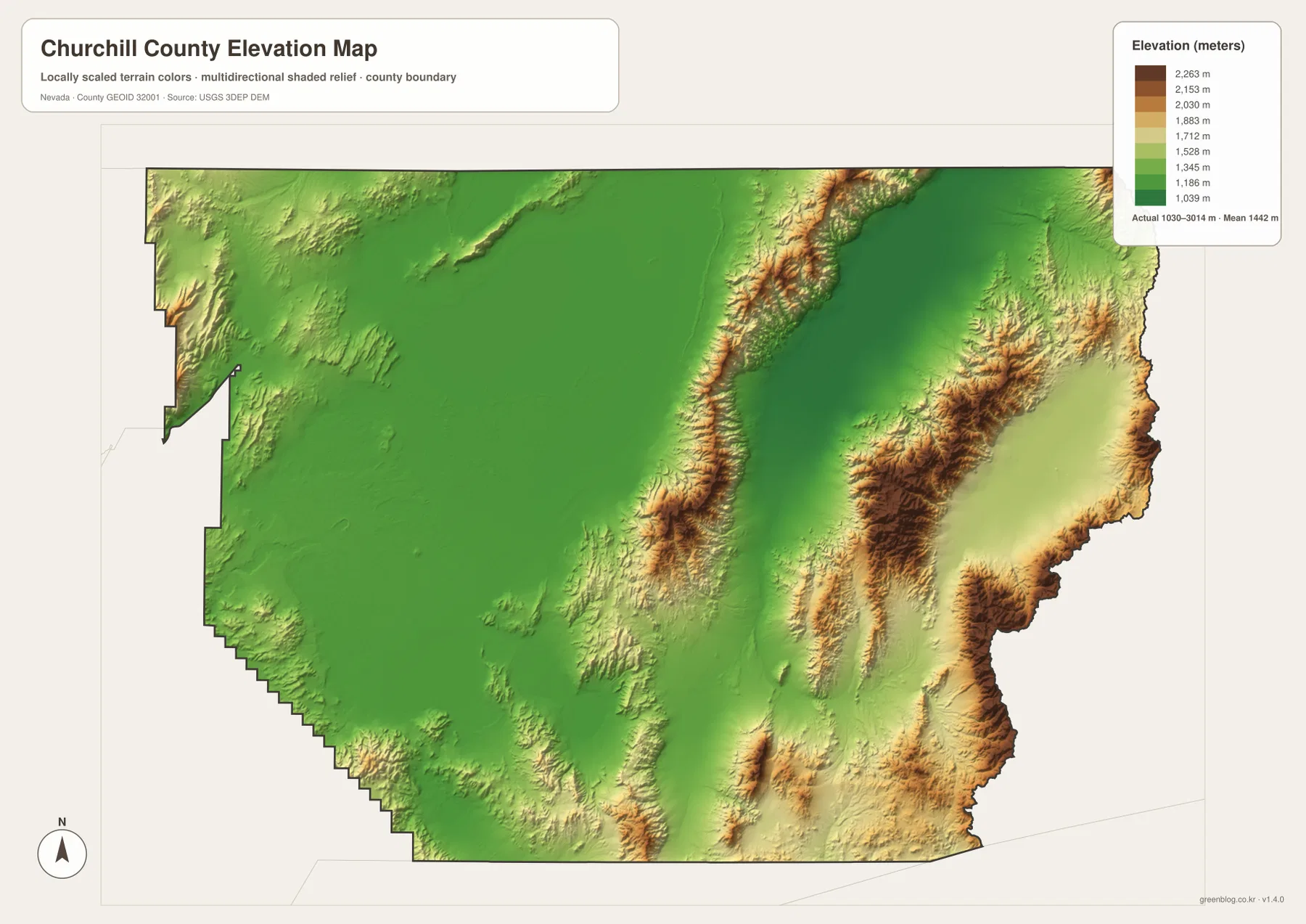
The east is not one continuous plateau. Separate ridges and valleys repeat across the county, and the named washes and creeks on the water map tend to follow those lower corridors. Stillwater wetlands and Fallon farmland occupy the opposite setting: a broad low basin where river and irrigation water collect and spread across comparatively level ground.
This elevation surface is for county-scale comparison rather than surveying or engineering. Exact parcel elevation, mountain-road grade, construction benchmarks, and technical design require appropriate USGS source data or professional surveying. The image is best used to compare the Fallon basin with the central ranges, Dixie Valley, and the higher eastern mountains.
How prehistoric Lake Lahontan, irrigation, and wetlands shaped the county
Churchill County’s official master plan notes that large parts of the county occupy the former basin of prehistoric Lake Lahontan. Long before modern irrigation, Northern Paiute communities used the Stillwater marshes and other wetland resources for food and materials. That history gives the present-day concentration of wetlands in the Lahontan Valley a much deeper context than a simple collection of reservoir labels.
Modern agriculture added another layer. The Newlands Reclamation Project began in the early twentieth century, and completion of Lahontan Dam helped deliver Carson and Truckee River water to irrigated farms around Fallon. The contrast on the maps is dramatic: cultivated and managed-water landscapes cluster in the low western valley, while much of the eastern county remains dry mountain and basin country.
Stillwater National Wildlife Refuge now protects a major part of that wetland system. Federal refuge information notes the importance of the area to migratory birds and other desert wildlife. For map users, the refuge is a useful reminder that open water and marsh in Churchill County are not simply recreational features; they are part of one of the most distinctive desert-wetland landscapes in Nevada.
Lahontan State Recreation Area adds another piece of the water story on the western side of the region. Nevada State Parks explains that Lahontan Reservoir was built as part of the irrigation system serving nearby farmland. The county maps on this page are not detailed recreation maps, so visitors should check current park and refuge information for access, boating, campground status, advisories, and seasonal conditions.
A useful order for comparing roads, wetlands, and mountain relief
Start with the general county map by finding Fallon and the U.S. 50–U.S. 95 junction. The local state routes around the city show the dense western travel network, while the longer roads into the central and eastern county reveal how quickly settlement thins. The city panel then makes the one-city concentration especially clear.
Next, trace the Carson River toward Carson Lake and the Stillwater wetland cluster, then compare those low-water areas with Dixie Valley Wash and the mountain creeks farther east. The elevation map completes the picture by showing which valleys lie low and which ranges rise thousands of feet above them. Looking at the water and elevation views together is the easiest way to understand why Churchill County contains both irrigated farmland and very dry mountain desert.
The high-resolution JPG files are more convenient than the WebP previews for printing or zooming into small stream and road labels. They remain reference maps rather than legal boundary, parcel, flood, navigation, or engineering products. For technical work, compare the maps with current U.S. Census Bureau, USGS, refuge, and state-agency data.
Frequently Asked Questions
Does the city map show distances from Fallon to other communities?
No. Fallon is the only ranked major city on the supplied city panel, and the graphic contains no connector lines or mileage table. Use current route information for actual driving distance or travel time to remote places.
Why are so many lakes and reservoirs clustered near Stillwater?
The Lahontan Valley northeast of Fallon contains a managed wetland and irrigation landscape where reservoirs, lakes, sloughs, and marshes occur close together. Stillwater National Wildlife Refuge protects a major part of this desert-wetland system.
Can the 1,030–3,014 meter elevation range be used for surveying?
No. Those values describe the generalized county-scale elevation surface. Parcel elevations, construction benchmarks, road grades, and engineering work require appropriate USGS source data or professional surveying.
Map File Information
Download the four high-resolution JPG maps shown on this page for Churchill County in one ZIP archive.
- Included Files: Use only the versions confirmed in the article and supplied images
- File Type: Use the confirmed download contents
- Intended Use: Printing, education, presentations, and map-based projects
Related Maps
Sources and references
County formation, Fallon county-seat history, Lake Lahontan, and irrigation background come from Churchill County’s official master plan. Stillwater wetland information comes from the U.S. Fish and Wildlife Service, and Lahontan Reservoir context comes from Nevada State Parks. The federal sources below provide authoritative boundary, hydrography, and elevation references.
- Churchill County – County Master Plan
- U.S. Fish and Wildlife Service – Stillwater National Wildlife Refuge
- Nevada State Parks – Lahontan State Recreation Area
- U.S. Census Bureau – TIGER/Line Shapefiles
- USGS – National Hydrography
- USGS – 3D Elevation Program
Green Map creates custom-edited map images using open geographic data sources such as geoBoundaries, Natural Earth, OpenStreetMap, and government open data. These maps are edited visual materials, not raw data files, and are provided for education, documents, presentations, and graphic reference.