Hooker County sits in Nebraska’s Sandhills, with Mullen near the northern side of the county, the Middle Loup River close to the north, and the Dismal River system crossing the southern half. Nebraska Highway 2 provides the main east–west route through the Mullen area, while Highway 97 turns south across a much more sparsely settled landscape. The maps on this page show the county boundary and roads, the unusual one-city distribution, named rivers and tributaries, and an elevation range of roughly 903 to 1,161 meters. The four original high-resolution JPG maps are also available together as a ZIP file for printing or closer viewing. High-resolution map files are available for download in the section below.
The county is easier to understand through terrain than through a long list of towns. Mullen is the main settlement and administrative reference, but much of Hooker County consists of rolling Sandhills cut by narrow stream valleys. The elevation surface is highest across the west and southwest and generally drops toward the east and northeast. In the north, the Middle Loup corridor lies close to the highway and Mullen; farther south, the Dismal River and its forks provide the more useful landmarks. Those differences make Hooker County a strong example of a place where roads, water, and relief need to be viewed together.
Table of Contents
Mullen gives Highway 2 and Highway 97 a clear meeting point in the Sandhills
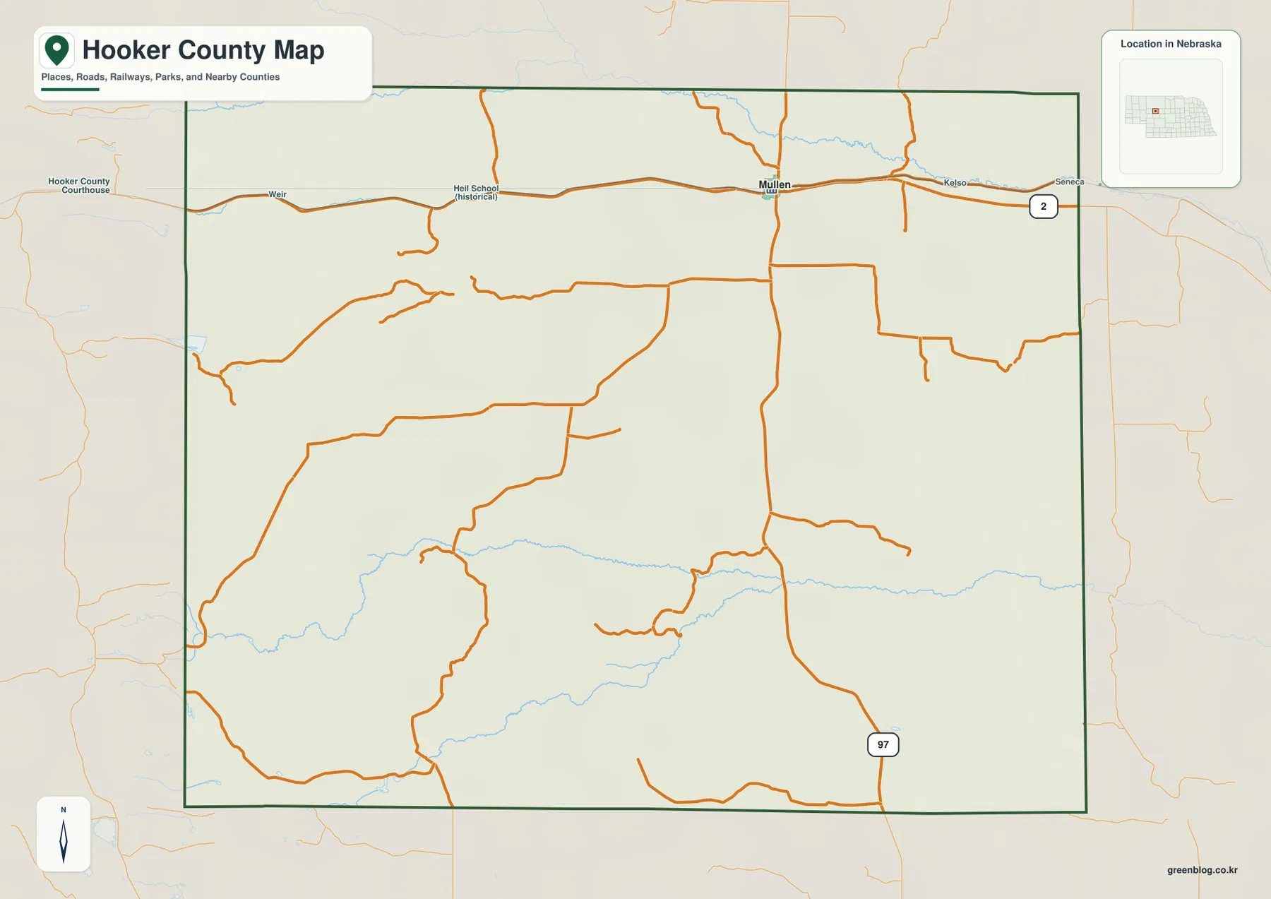
Mullen is the most useful starting point on the general county map. Nebraska Highway 2 crosses the northern part of Hooker County from west to east, and Highway 97 meets that corridor at Mullen before heading south. Weir is labeled along the route to the west, while Kelso and the Seneca area appear farther east. There is no dense urban road network here, so the simple meeting of one east–west highway and one north–south highway becomes an especially strong orientation feature.
South of Mullen, the road pattern becomes much thinner. Highway 97 continues through open Sandhills country and bends as it approaches the Dismal River corridor, while local roads branch through the interior. The contrast between the relatively straightforward northern highway line and the winding routes farther south reflects the rolling terrain shown more clearly on the elevation map. The county sheet is useful for understanding relative position, but it does not provide current pavement status, winter conditions, construction closures, or turn-by-turn navigation.
The neighboring counties create a simple outer frame. Cherry County is to the north, Thomas County to the east, McPherson County to the south, Arthur County to the southwest, and Grant County to the west. Most of the county boundary is geometric, yet the land inside it is anything but flat or uniform. Long ridges, river valleys, and short tributaries run across the administrative lines, so the boundary is best used as a location reference rather than as a description of the physical landscape.
A one-city index makes Hooker County’s sparse settlement pattern unmistakable
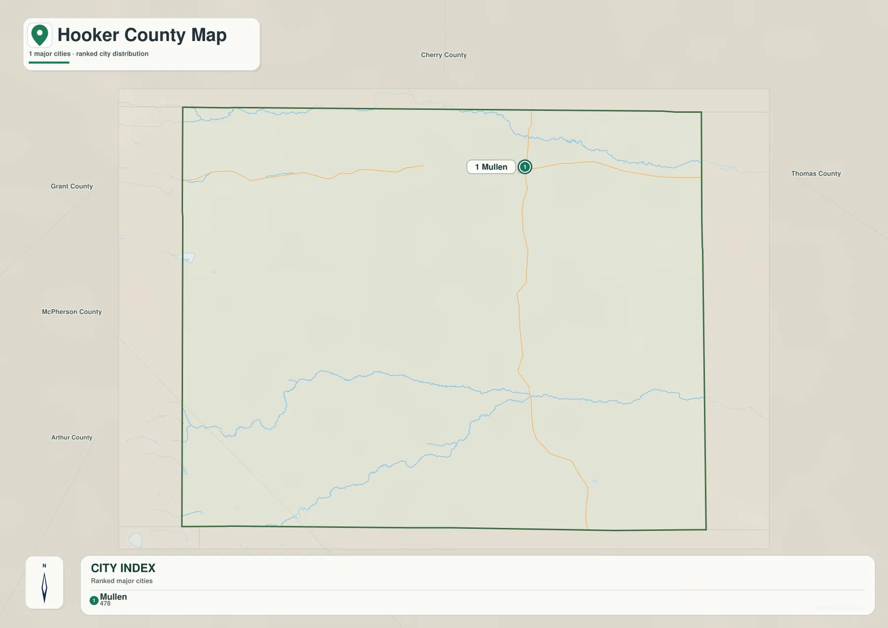
The city-distribution map is unusually simple. It identifies only one major city, placing Mullen at rank 1 and printing an index value of 478. That number belongs to the supplied map and is best treated as a map index rather than a live population count. The more important message is geographic: a large county-sized area has just one settlement prominent enough to appear in this ranked view, and that settlement sits near the northern highway corridor instead of at the geographic center.
Hooker County’s official website lists Mullen, Kelso, and Weir among its cities and villages, and the general map shows those smaller place names along Highway 2. The ranked city map still emphasizes only Mullen. Comparing the two sheets prevents a common misunderstanding: a place can be labeled on the county map without being included in the major-city index. Use the general map when you need smaller named places and the city sheet when you want to see how strongly Mullen stands out as the county’s principal settlement.
Mullen’s position also has a clear historical background. History Nebraska records that a Burlington railroad branch reached the area in 1887 and created a siding named Mullen, and the village was platted the following year. Hooker County was established in 1889 with Mullen as the county seat. The modern map still reflects that concentration of functions: the county seat, the main east–west route, and the principal north–south highway all meet in the same small community.
The Middle Loup frames the north while the Dismal River system organizes the south
The Middle Loup River is the dominant water feature along the northern side of the terrain-and-water map. It enters from the west, runs eastward near the upper edge of the county, and passes north of the Mullen and Highway 2 corridor. On the elevation map, the river follows a lower green band, especially toward the northeast. This makes the northern part of Hooker County more varied than it appears on the road map alone: a major highway, the county seat, and a distinct river valley are all packed into a relatively narrow part of the county.
The southern half is organized by the Dismal River and its branches. The Dismal River crosses the lower interior, while the North Fork Dismal River approaches from the west and the South Fork Dismal River curves through the southwest. Smaller named channels include Babbitt Creek and Spring Creek, and the map also labels a South Fork connection within the drainage network. Rather than forming one broad flat valley, these streams occupy separate low corridors between long Sandhills ridges.
The Middle Loup and Dismal systems are separated by a broad belt of rolling upland. That separation is important because it divides the county into two very different map-reading zones. North of the interior uplands, Mullen and Highway 2 provide familiar settlement and transportation markers. Farther south, there are few town labels, so rivers, forks, and road crossings become the better references. The water map makes this transition much easier to understand than the county boundary alone.
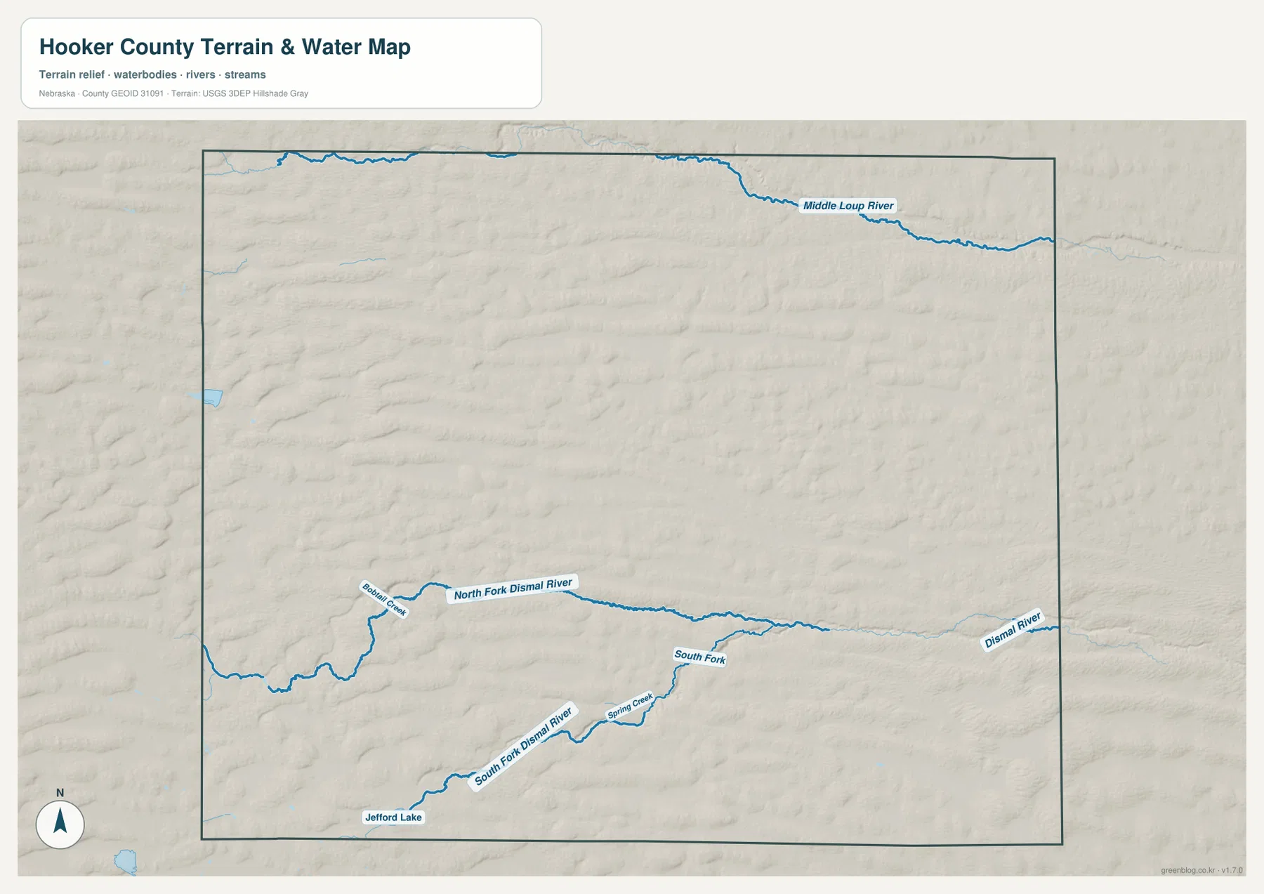
This is a geographic water-reference map, not a flood, parcel, boating, or real-time river product. A blue line does not show current discharge, public access, channel depth, or legal water rights. Conditions in Sandhills streams can also vary with season and location. For general study, the map is most useful for showing which river system belongs to which part of the county; current safety or regulatory questions should be checked against the appropriate official source.
Jefford Lake and the Dismal forks provide landmarks where town names disappear
In southwestern Hooker County, water names become more useful than settlement names. Jefford Lake is marked near the lower-left part of the water map, and the South Fork Dismal River curves through the broader area to its north and east. Spring Creek joins that southern drainage, while the North Fork Dismal River and Babbitt Creek appear farther north. These features give readers a way to locate portions of the county that otherwise contain few prominent labels.
The same streams line up closely with low corridors on the elevation surface. Brown and tan ridges dominate the western high ground, and greener troughs cut between them. The North Fork and South Fork Dismal River follow those lower passages toward the east, which makes their winding paths easier to understand. Instead of memorizing each channel as an isolated name, it is more useful to see the forks as parts of a drainage network threaded through the Sandhills.
Jefford Lake and the smaller creeks are location references on this page, not statements about recreational access. The maps do not give lake depth, water quality, fishing rules, ownership, or public-entry information. Those details require separate management sources. Here, the value of the smaller water features is that they break up a large rural area and help connect the water map with the ridges and valleys visible on the terrain surface.
Elevation falls from 1,161-meter western ridges toward lower eastern valleys
The elevation map gives an actual county-wide range of about 903 to 1,161 meters, with a mean near 1,030 meters. Higher brown and orange terrain is concentrated in the west and southwest, while the east and northeast contain much more green. The difference between the mapped minimum and maximum is roughly 258 meters. Hooker County is not mountainous, but that amount of relief is enough to produce a striking pattern of ridges and narrow valleys across the Sandhills.
A simple west-to-east decline is only part of the story. The western side is packed with short, rounded ridges and hollows, while central Hooker County has many elongated hills that run broadly east–west. Lower corridors follow the Middle Loup in the northeast and the Dismal River system across the south. Tributaries carve green fingers into surrounding higher ground, so the surface looks textured even where the overall elevation changes gradually.
Highway 97 offers a useful way to connect the road and elevation maps. From Mullen it heads south through rolling uplands before approaching the lower Dismal River corridor. Highway 2, by contrast, stays close to the northern river-and-valley zone. The roads do not simply follow contour lines, but comparing them with shaded relief explains why travel through different parts of the county feels different on the map: northern routes stay near a broad corridor, while southern roads cross repeated Sandhills ridges and drainage cuts.
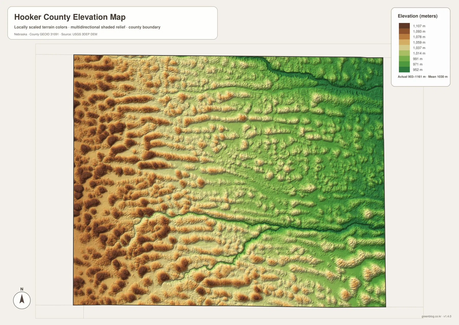
The elevation surface is generalized for county-scale comparison. It is not survey-grade information for a parcel, building pad, drainage plan, road design, or engineering project. Those tasks require current high-resolution elevation data such as the USGS 3D Elevation Program and, when appropriate, professional field measurements. For regional geography, however, the 903–1,161 meter range and the shaded ridges clearly show why Hooker County should not be imagined as a flat rectangle on the Nebraska map.
Hooker County is easier to remember as three linked geographic zones
One practical way to remember the county is to divide it into three broad zones. The north is the Mullen–Highway 2–Middle Loup corridor, where most of the named settlement and transportation information is concentrated. The center is largely rolling Sandhills crossed by Highway 97 and local roads. The south is the Dismal River country, where the main river, its forks, and smaller creeks become the strongest landmarks. This is not an official regional division; it is simply a useful way to match the features visible on the supplied maps.
The neighboring counties reinforce that orientation. Grant County lies west of the higher Sandhills, Cherry County is north of the Middle Loup side, Thomas County borders the lower eastern side, and McPherson County continues the southern Sandhills beyond the boundary. Arthur County touches the southwest corner. Natural terrain continues across all of those lines, so the county border is best understood after the main rivers, roads, and ridges have already been located.
History Nebraska’s account of Mullen also fits this geographic picture. The county developed around a small railroad community rather than a network of large towns, and the surrounding Sandhills remained a major part of the local setting. On the modern maps, that history is visible without needing a dense layer of labels: Mullen remains the unmistakable center, while most of the county is defined by open terrain, drainage, and long-distance roads rather than urban development.
Choose the map by whether you need a place, a stream, or the shape of the land
Start with the general county map when the question is where Mullen, Weir, Kelso, Highway 2, Highway 97, or a neighboring county is located. The city-distribution map is intentionally narrower: it strips the picture down to Mullen as the single ranked major city and makes the county’s sparse settlement pattern obvious. Those two sheets are best for location and settlement context.
Use the terrain-and-water map when the subject is the Middle Loup River, Dismal River, the North and South Forks, Spring Creek, Babbitt Creek, or Jefford Lake. The elevation map answers a different question by showing where the county is higher and lower. Placing the water and elevation versions side by side makes the relationship especially clear because the major streams occupy green low corridors between tan and brown Sandhills ridges.
The WebP images on the page are convenient previews, while the original JPG files are better for enlarging labels or printing. All versions remain general-reference maps. Property boundaries, flood decisions, live road conditions, public-access questions, and engineering work should rely on the latest authoritative source for that specific purpose.
Frequently Asked Questions
Why does the city-distribution map show only Mullen?
The supplied city map ranks major cities and includes only Mullen. The general county map still labels smaller places such as Weir and Kelso along Highway 2, so the two maps are serving different purposes. Use the city sheet to understand the dominant settlement center and the general map when you need smaller named places.
Does the Dismal River run beside Mullen?
No. Mullen is in northern Hooker County near Highway 2 and the Middle Loup River corridor. The Dismal River system is much farther south. Highway 97 provides a useful north–south reference between the Mullen area and the Dismal River, while the North Fork and South Fork occupy separate valleys in the southwestern half of the county.
Can the 903–1,161 meter elevation range be used for surveying?
No. The range is a generalized county-scale summary that is useful for comparing high western Sandhills with lower eastern and river-valley terrain. Parcel surveys, construction, drainage design, and road engineering require current detailed elevation data and professional measurements rather than this regional map.
Map File Information
The county, city-distribution, terrain-and-water, and elevation maps described on this page are available together in one ZIP file. It contains four original high-resolution JPG maps suitable for printing and detailed viewing.
- Included Files: County map, city-distribution map, terrain-and-water map, elevation map
- File Type: JPG files in a ZIP archive
Related Maps
Sources and references
These official and public sources provide additional context for Hooker County government, local history, administrative boundaries, waterways, and elevation. The maps on this page are simplified for readable regional reference, so legal, engineering, and current-condition decisions should be checked against the original authoritative datasets and notices.
- Hooker County, Nebraska official website – county government and community information
- History Nebraska – Mullen, Hooker County – Mullen and county-history background
- U.S. Census Bureau TIGER/Line – administrative boundary and geographic reference data
- USGS National Hydrography – river and stream data
- USGS 3D Elevation Program – elevation data
Green Map creates custom-edited map images using open geographic data sources such as geoBoundaries, Natural Earth, OpenStreetMap, and government open data. These maps are edited visual materials, not raw data files, and are provided for education, documents, presentations, and graphic reference.