Yellowstone County in south-central Montana is organized around Billings and the broad Yellowstone River valley, but the county extends far beyond the urban area into plains, creek valleys, and higher southern country. Billings and Laurel sit close together in the western half, while Broadview lies to the northwest. Interstate 90, Interstate 94, and the Yellowstone River provide clear reference lines for understanding how the county’s communities and transportation routes fit together.
This page explains the county boundary and road network, the main city connections, waterways and reservoirs, and the county-wide elevation pattern. The same maps are also available as original high-resolution JPG files in a ZIP download for printing, classroom use, and personal geographic reference.
Table of Contents
Billings anchors a large county in south-central Montana
Yellowstone County lies in south-central Montana, with Billings serving as the county seat. The county’s official profile states that Yellowstone County was established in 1883 and describes Billings as the principal population and service center. That role is immediately visible on the map, where highways, local roads, rail lines, and the Yellowstone River corridor all converge in and around the city.
The county boundary is irregular rather than rectangular. Golden Valley and Stillwater Counties lie to the west, Carbon County is southwest, and Big Horn County borders the south and southeast. Rosebud County is to the east, while the northern edge reaches toward Musselshell County. The northeastern boundary has several stepped sections, so keeping the full county outline visible is useful when following roads or creeks near the edge.
I-90 and I-94 meet the Yellowstone River corridor at Billings
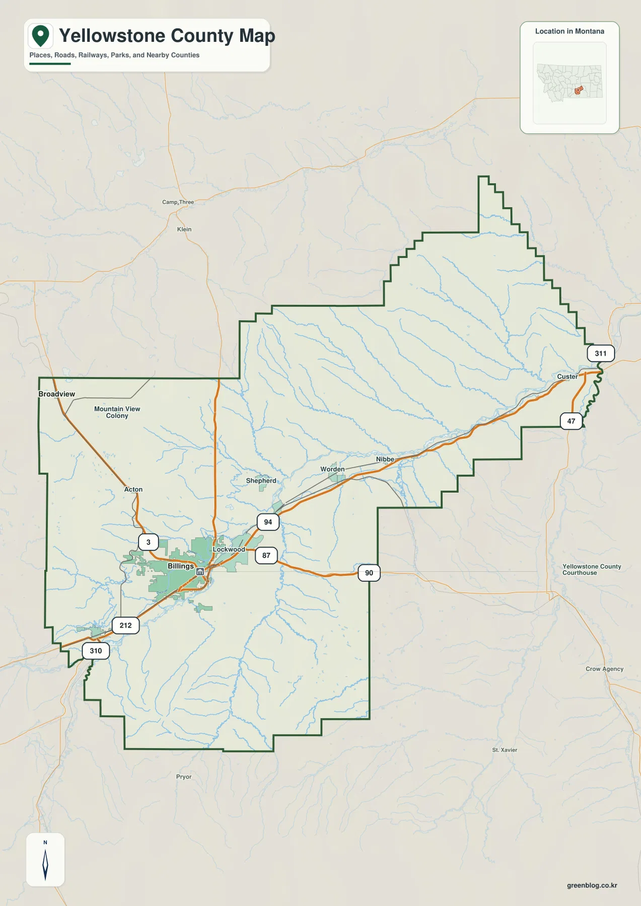
The road map is centered on Billings. Interstate 90 approaches from the Laurel side, passes through the Billings area, and continues east, while Interstate 94 follows the Yellowstone River corridor toward Custer. U.S. 87, Route 3, U.S. 212, and U.S. 310 also meet or approach the Billings-Laurel area, creating the county’s densest concentration of major routes.
Laurel lies southwest of Billings near the lower valleys of the Yellowstone and Clarks Fork rivers. Broadview is much farther northwest along Route 3. East of Billings, the map labels Lockwood, Shepherd, Worden, and Nibbe before the corridor reaches the Custer area. Those places help show the transition from the urbanized western valley to the more widely spaced rural communities farther east.
Near Custer, Routes 47 and 311 provide additional north-south connections. The general map is useful for understanding direction and relative location, but it does not show current road conditions, construction, or exact driving times. Rural routes in the southern and northeastern parts of the county may follow terrain and stream valleys rather than a direct line.
Billings is 13 straight-line miles from Laurel and 26 from Broadview
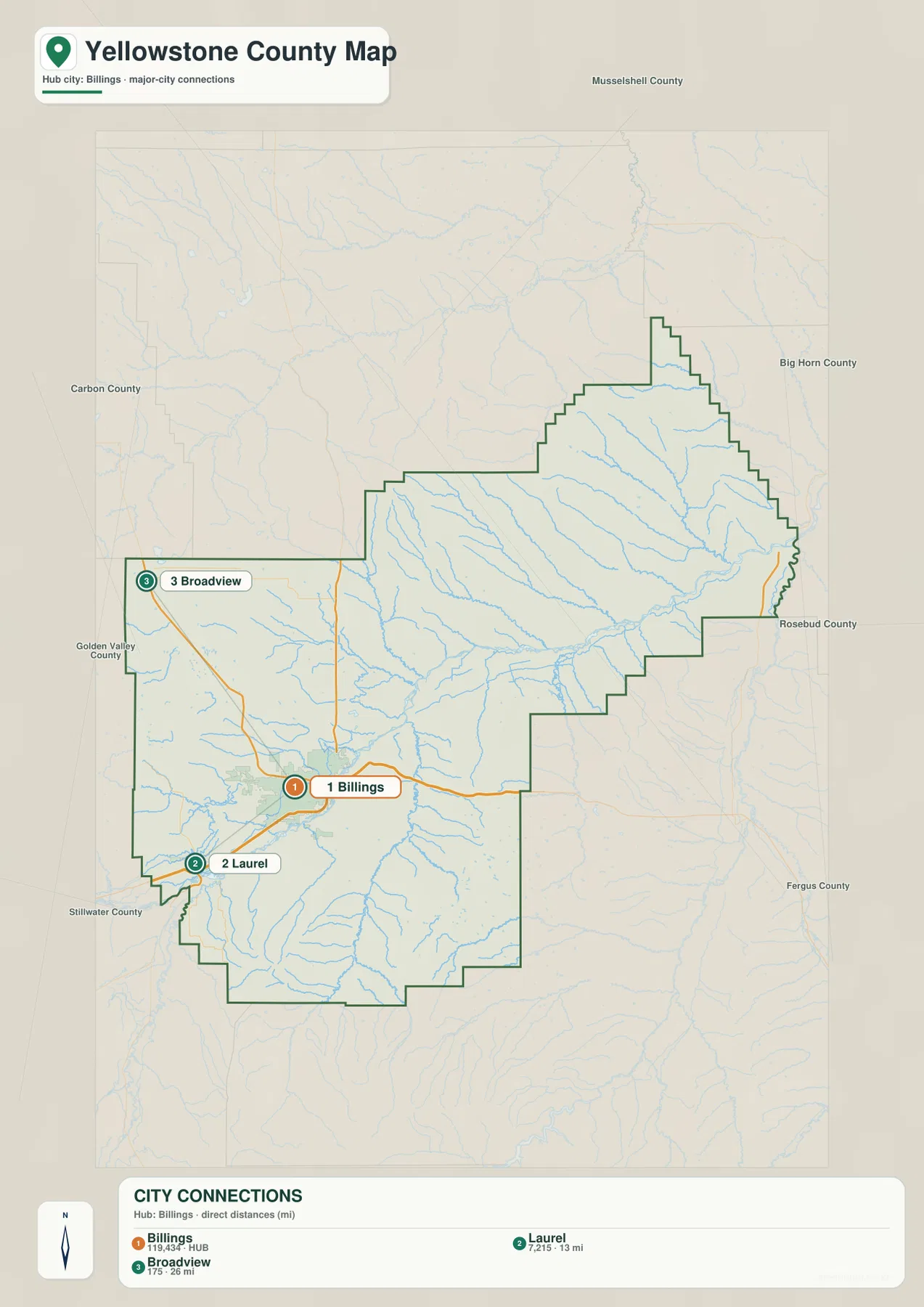
The city-connection map uses Billings as the hub. It shows a straight-line distance of about 13 miles from Billings to Laurel and about 26 miles from Billings to Broadview. These are direct point-to-point measurements rather than road mileage, so an actual drive can be longer depending on the route and the exact starting and ending locations.
Laurel sits close to Billings within the same broad Yellowstone River corridor, while Broadview is separated from the urban area by open country to the northwest. That contrast makes the map more useful than a simple ranked list of places. It shows that two of the county’s principal communities are clustered in the western valley while the third occupies a more isolated plains setting.
Yellowstone County’s official profile identifies Billings as the county seat and lists Laurel and Broadview among the county’s incorporated communities. The connection map is intended to compare their relative positions, not to substitute for a road atlas. For commuting, delivery planning, or travel, the latest routed distance should be used instead of the straight-line values.
The Yellowstone River ties together the county’s central lowland
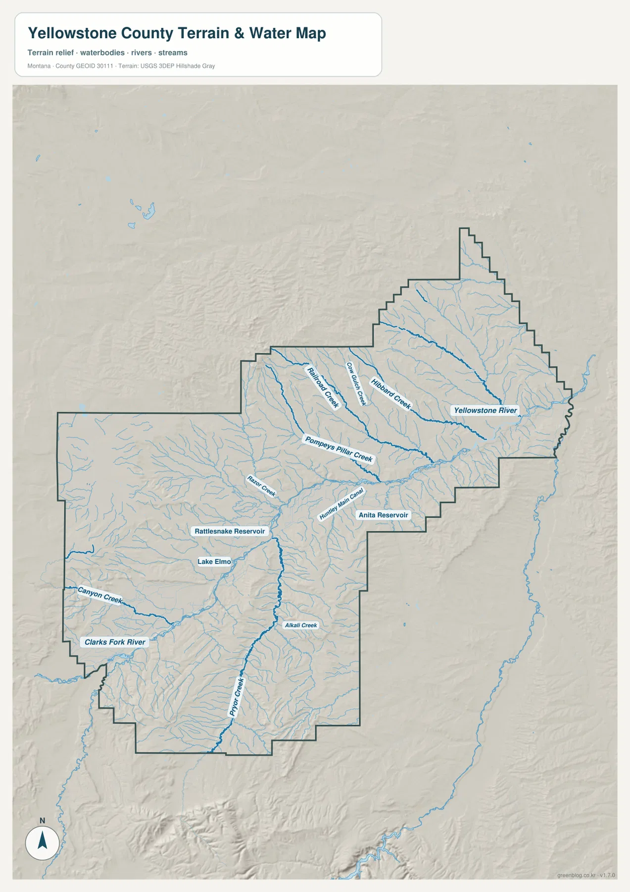
The Yellowstone River is the dominant water feature. It enters the county from the southwest, passes through the Laurel and Billings area, and continues east toward Custer. The river occupies a broad, low corridor that also carries much of the county’s transportation and settlement. Its course provides a natural geographic reference for finding both the urban area and the rural communities downstream.
The Clarks Fork River approaches from the southwest near Laurel, while Canyon Creek descends from the west and southwest toward the same central lowland. South of Billings, Pryor Creek and Alkali Creek run through long valleys that cut northward across the higher terrain. Farther east and northeast, Pompeys Pillar Creek, Hilbard Creek, Cow Water Creek, and Railroad Creek descend toward the Yellowstone River system.
Lake Elmo, Rattlesnake Reservoir, and Anita Reservoir are also labeled, along with the Huntley Main Canal. Seeing natural streams, impoundments, and an irrigation canal on one map is useful for understanding the variety of water features within the county. The map is not a floodplain, water-right, navigation, depth, or property-boundary product, so those questions should be checked against current agency records.
Elevation ranges from about 821 to 1,515 meters
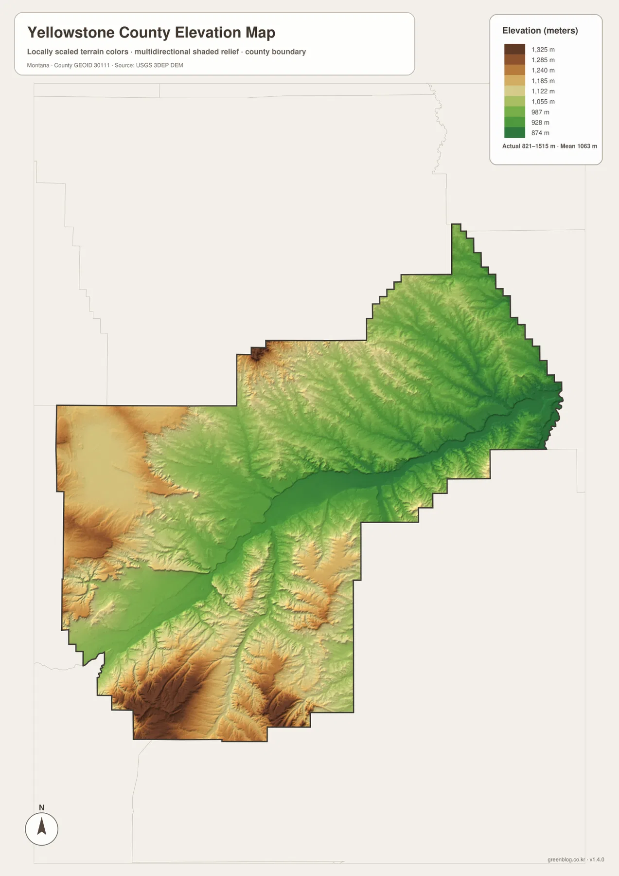
The elevation map reports an actual county-wide range of about 821 to 1,515 meters, with a mean near 1,063 meters. The lowest greens follow the Yellowstone River corridor from the southwest through Billings and then eastward. Laurel and Billings both sit close to this lower band, which forms the county’s most continuous lowland.
Elevation rises away from the river. The southern and southwestern parts of the county contain broad tan and brown uplands broken by narrow creek valleys, while higher ground also appears along parts of the western edge. North of the river the terrain is generally less dramatic, but a dense pattern of small valleys and rolling ridges becomes visible toward the northeast.
The color ramp is scaled locally for Yellowstone County, so it is best used to compare places within this map. A similar color on another county map may correspond to a different absolute elevation. The surface is generalized for regional viewing and should not be treated as survey-grade data for engineering, construction, drainage design, or parcel work.
Why major roads and cities follow the lower river valley
Putting the road and elevation maps side by side explains much of the county’s settlement pattern. Billings and Laurel occupy the lower Yellowstone corridor, and I-90 and I-94 use the same broad lowland rather than crossing the highest southern uplands. The combination of flatter terrain, a major river, and intersecting transportation routes helps explain why the western river valley contains the county’s densest urban development.
Broadview sits outside that river corridor on the plains to the northwest, connected to Billings by Route 3. South of the river, settlement becomes more dispersed as the land rises and creek valleys cut through the uplands. Yellowstone County therefore combines a major metropolitan area with large rural sections that look very different on the map.
Reservoirs and canals add another layer to the water map
The county’s water geography is not limited to the Yellowstone River and its natural tributaries. Lake Elmo lies near the Billings area, Rattlesnake Reservoir appears farther west, and Anita Reservoir is shown east of the city. These features differ in size and purpose, but they provide useful reference points for understanding where stored water appears within the larger drainage network.
The Huntley Main Canal stands out because it is an engineered waterway rather than a natural creek. Its presence alongside rivers and reservoirs illustrates how irrigation infrastructure overlaps with the natural landscape. The map does not indicate operating schedules, legal access, current water levels, or water rights, so it should be used only for geographic orientation.
An 1883 county shaped by Billings and the Yellowstone River
Yellowstone County’s official profile states that the county was established in 1883. Billings became the county seat and grew into Montana’s largest urban center, while the Yellowstone River continued to support agriculture, transportation, and recreation across the surrounding valley. The modern map still shows that relationship clearly: roads, rail lines, communities, and water features all concentrate around the same central corridor.
The county name itself comes from the Yellowstone River, making the river both a historical and geographic reference. Beyond Billings, the county includes Laurel, Broadview, rural settlements, agricultural land, and higher uplands. That range of settings is why separating the county map, city map, water map, and elevation map is useful; each one reveals a different part of the same landscape without crowding all details into one image.
Choosing the right map for the question
For basic orientation, start with Billings and the Yellowstone River. From Billings, follow I-90 southwest toward Laurel and I-94 east toward Custer, then use Route 3 to locate Broadview to the northwest. This approach quickly establishes the county’s principal directions and the relationship between the urban area and outlying communities.
For physical geography, trace the Yellowstone River first and then follow the Clarks Fork River, Canyon Creek, Pryor Creek, and Alkali Creek into the surrounding terrain. The elevation map makes the same valleys visible as lower green corridors between higher ridges. The water and elevation views therefore work especially well together when explaining why the landscape changes from the central valley to the southern uplands.
For printing or classroom use, the high-resolution JPG files in the download archive are preferable to the smaller web previews. The county map is strongest for roads and boundaries, the city map for Billings-Laurel-Broadview relationships, the water map for rivers and reservoirs, and the elevation map for comparing the valley floor with higher ground.
Frequently Asked Questions
Are the 13- and 26-mile city distances driving distances?
No. The city map shows straight-line distances from Billings: about 13 miles to Laurel and 26 miles to Broadview. Actual driving distance depends on the road network and the exact starting and ending points.
How does the Yellowstone River cross the county?
The river enters from the southwest near the Laurel area, passes through the broad Billings valley, and continues east toward Custer. Much of the county’s major transportation network follows this lower corridor, making the river a useful reference line for reading both the road and elevation maps.
Can the 821-1,515 meter elevation range be used for engineering or surveying?
No. The range summarizes a generalized county-wide surface intended for relative geographic comparison. Engineering, construction, drainage, and surveying require original elevation data and, where appropriate, professional field measurements.
Map File Information
The ZIP contains the original high-resolution JPG files for the Yellowstone County boundary and road map, city-connection map, terrain and water map, and elevation map.
- Included Files: Use only the versions confirmed in the article and supplied images
- File Type: Use the confirmed download contents
- Intended Use: Printing, education, presentations, and map-based projects
Related Maps
Sources and references
- Yellowstone County official website
- Yellowstone County – About the County
- U.S. Census Bureau TIGER/Line Shapefiles
- USGS National Hydrography
- USGS 3D Elevation Program
These maps are intended for geographic reference. For legal boundaries, land ownership, flood determinations, water rights, road conditions, construction, surveying, or other decisions requiring current authoritative information, consult Yellowstone County and the responsible state or federal agency.
Green Map creates custom-edited map images using open geographic data sources such as geoBoundaries, Natural Earth, OpenStreetMap, and government open data. These maps are edited visual materials, not raw data files, and are provided for education, documents, presentations, and graphic reference.