Wibaux County is a long, narrow county on Montana’s eastern edge, where the state meets North Dakota. The town of Wibaux and Interstate 94 form the clearest reference point near the middle of the county, while the landscape changes from lower northern country to more strongly dissected hills in the south. Beaver Creek runs through much of the county, and a very short piece of the Yellowstone River touches the far northwest corner. High-resolution map files are available for download in the section below.
This page brings those features together through boundary and road, city, water, and elevation maps. The original high-resolution JPG versions of the supplied maps are also available in one ZIP below, making them convenient for printing, classroom material, or personal geographic reference.
Table of Contents
A narrow eastern Montana county beside the North Dakota line
Wibaux County follows Montana’s border with North Dakota for its entire eastern side. Richland County meets it on the north, while Dawson, Prairie, and Fallon Counties border different sections of the west and southwest. The county is noticeably longer north to south than east to west, and its western boundary steps inward and outward several times rather than following one simple straight line.
Montana State University Extension describes Wibaux County as a small rural county on the North Dakota border and identifies Wibaux as both the county seat and its only incorporated town. The Montana Historical Society records the county’s creation date as August 17, 1914. Those facts fit the map well: one town provides the main civic reference point, while most of the county consists of open rural land crossed by roads, creeks, and shallow valleys.
I-94 makes Wibaux the easiest place to orient the road map
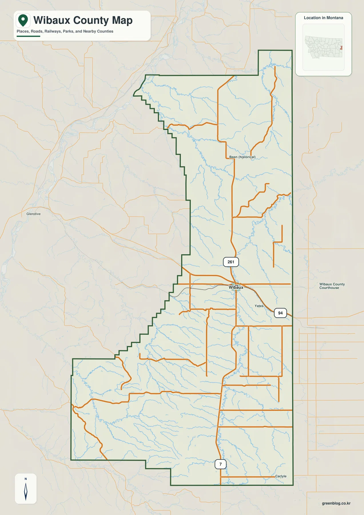
The general county map places Wibaux a little south of the county’s midpoint, directly on Interstate 94. The interstate enters from the Glendive side, passes through Wibaux, and continues across the North Dakota line, giving the county a clear east-west transportation reference. A road marked 261 extends north from the Wibaux area, while Highway 7 runs south through the lower part of the county.
Yates is labeled southeast of Wibaux, and the historical place name Been appears farther north. Looking outside the boundary adds useful context: Glendive is visible to the west, and Carlyle appears beyond the southeastern edge. These labels help establish direction, but they should not all be treated as present-day municipalities with the same legal status. Current addresses and jurisdictional questions should be checked with authoritative local records.
Road spacing changes markedly away from Wibaux and I-94. The center of the county has several connecting roads, while the far north and broad southwestern section contain longer gaps between routes. That pattern is one reason the map works best as an orientation tool rather than a substitute for live navigation. Road surface, closures, seasonal conditions, and exact driving mileage should be checked separately before travel.
Why the city map has only one ranked place
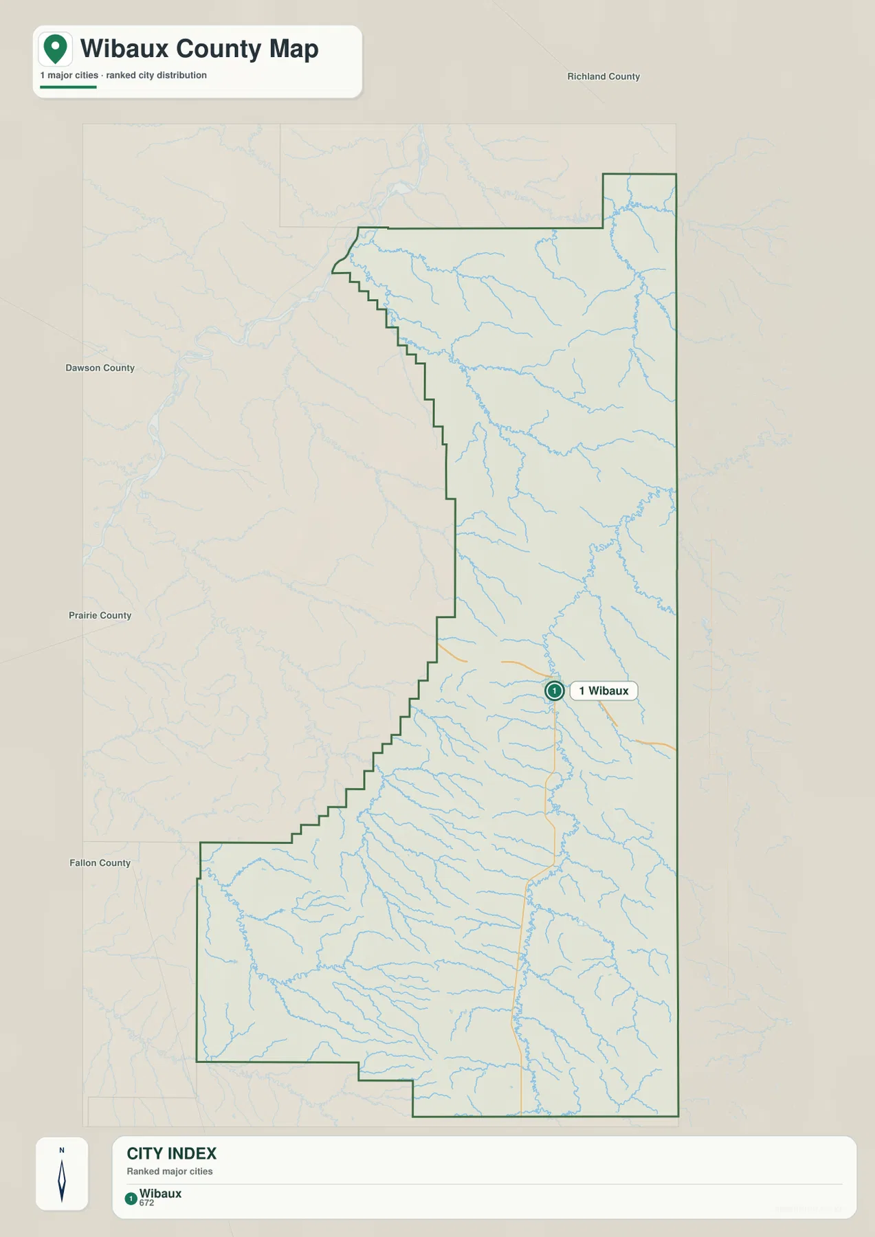
The city distribution map contains one ranked major place: Wibaux. With no second ranked city to compare, there is no city-to-city connector or straight-line mileage. That is intentional rather than missing information. In a county with one incorporated town, the more useful question is where that town sits in relation to the boundary, highway, and surrounding countryside.
Wibaux is very close to the North Dakota state line and sits where the county’s main east-west highway meets routes that extend north and south. MSU Extension likewise identifies it as the county seat and the county’s only incorporated town. Using Wibaux as the starting point makes the rest of the map easier to read, especially when locating rural roads or following Beaver Creek through the interior.
A one-city map also avoids a misleading impression of urban density. Wibaux County is predominantly rural, so scattered historical names and road junctions should not be presented as if they were equivalent population centers. The city layer therefore provides a clean view of the county’s principal town without forcing a comparison that the local settlement pattern does not support.
Beaver Creek links many of the county’s smaller drainages
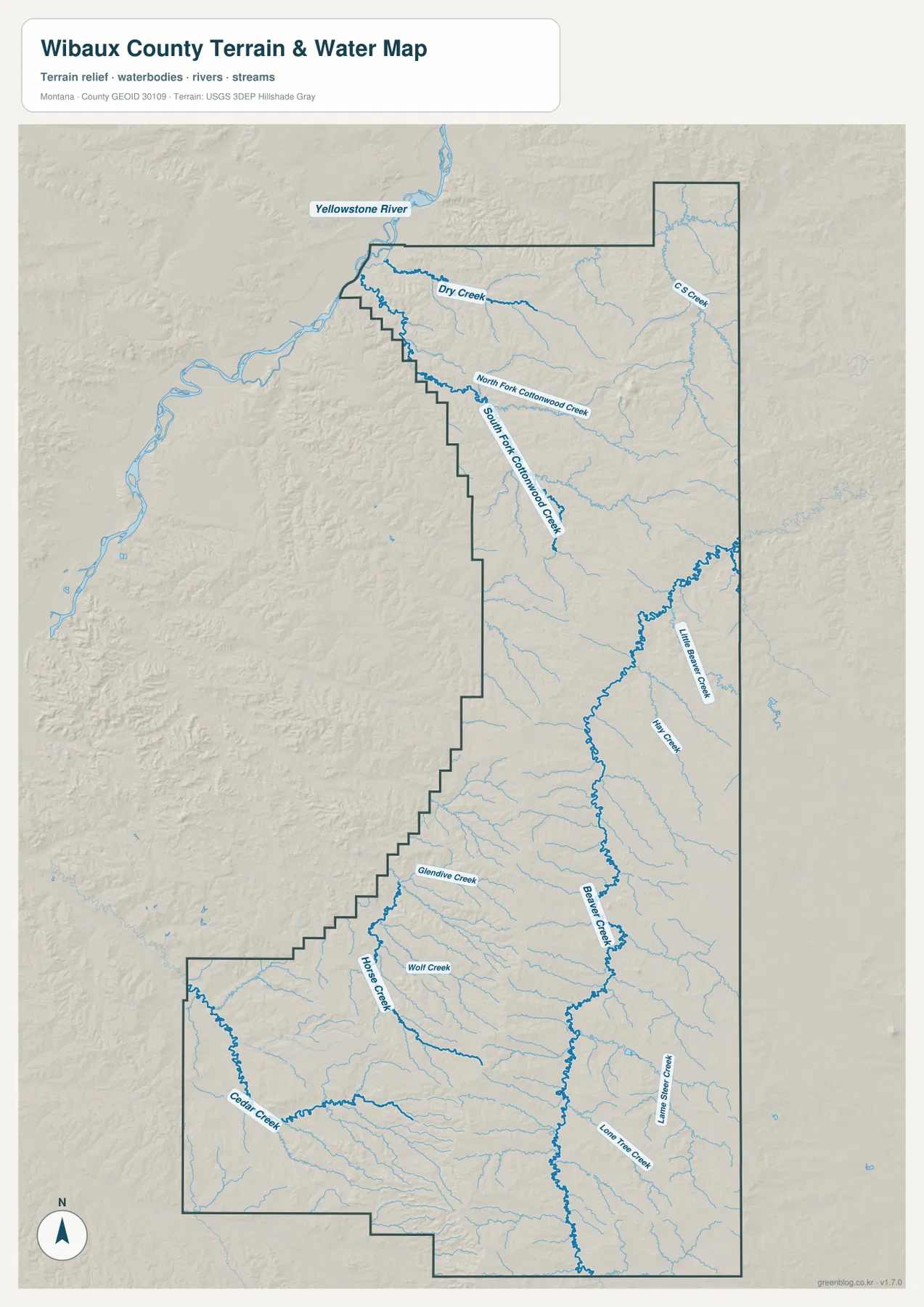
Beaver Creek is the most prominent internal watercourse on the supplied terrain and water map. It runs for a long distance through the eastern-central part of Wibaux County and receives water from numerous smaller valleys. The USDA Natural Resources Conservation Service’s county long-range plan identifies Beaver Creek as the county’s only perennial stream, which helps explain why it stands out among the many smaller creeks shown on the map.
In the north, Dry Creek and the North and South Forks of Cottonwood Creek spread across the lower terrain. Little Beaver Creek and Mill Creek appear farther east. Moving into the center and south, Glendive Creek, Wolf Creek, and Horse Creek descend from the western side, while Cedar Creek is a major reference in the broad southwestern section. Together these named streams show how the county is divided into many small valleys rather than one broad river plain.
The Yellowstone River appears only at the extreme northwest corner. The NRCS plan notes that it marks just under three miles of the county’s northwest boundary. This is important because the map label is visually prominent even though the river does not cross the county from end to end. Most of Wibaux County’s internal drainage is associated with smaller creeks, especially the Beaver Creek system.
This map is designed to show relative locations of water features and terrain. It does not indicate legal water rights, flood zones, parcel boundaries, stream access, or whether a small creek is flowing at a particular time. Those questions require current records from the appropriate county, state, or federal agency.
Elevation climbs from the greener north into rugged southern hills
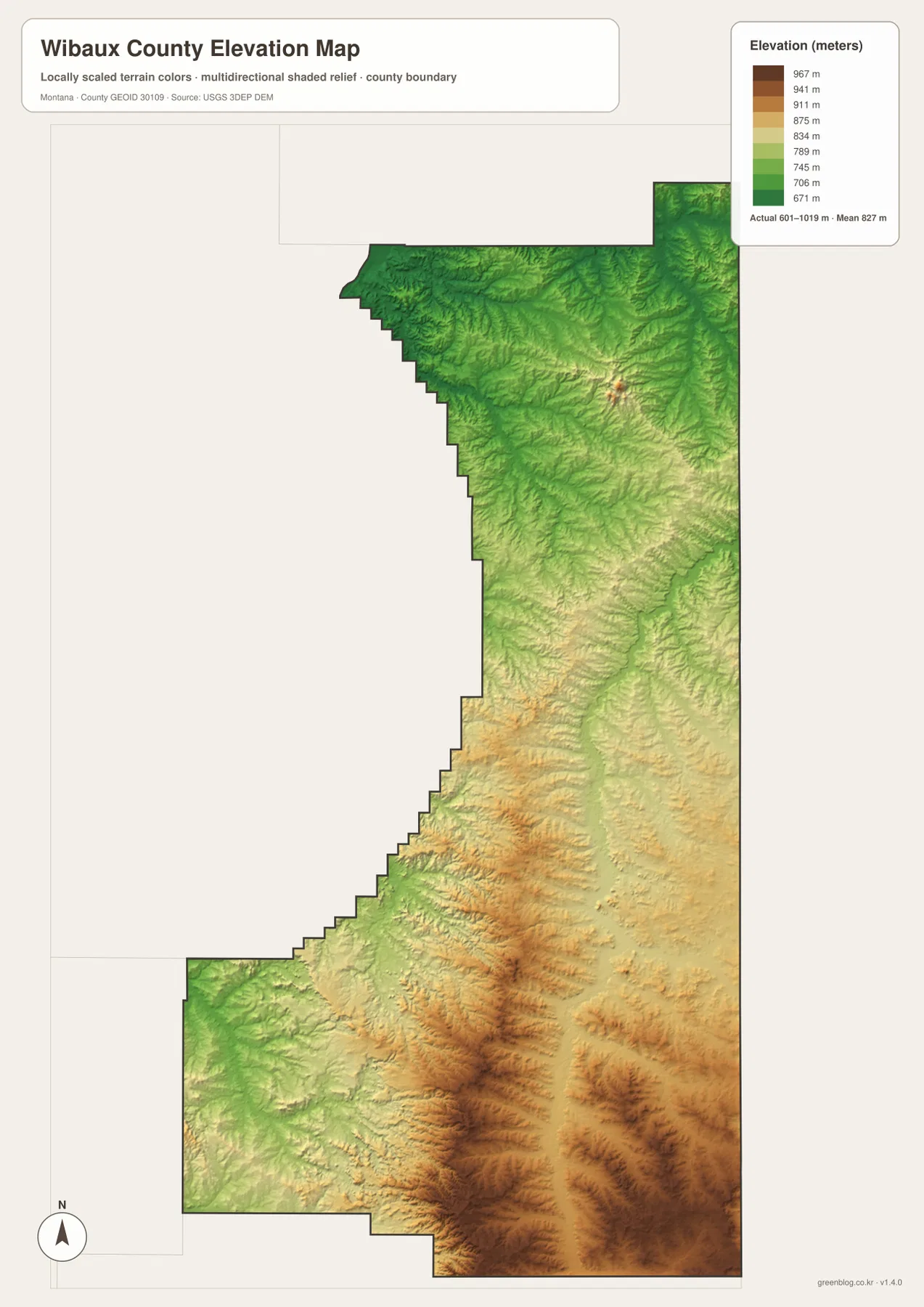
The elevation map reports an actual range of approximately 601 to 1,019 meters, with a mean near 827 meters. Much of the north and northwest is shown in green, indicating lower terrain within the county. Colors shift through pale green and tan toward the south, where higher ridges and more pronounced valleys become common.
The southern half is not simply one high plateau. Narrow lower valleys wind between ridges, and the Beaver Creek drainage appears as a lower corridor through parts of the higher country. The southwestern Cedar Creek area is similarly cut by many small valleys. This relief gives the lower half of the county a rougher appearance than the broad, greener terrain farther north.
The colors are scaled locally for Wibaux County, so they are most useful for comparing one part of this map with another. A matching shade on a different county map may represent a different absolute elevation. The surface is also generalized for regional display and should not be treated as survey-grade elevation for engineering, construction, drainage design, or property work.
Roads and creeks make the Wibaux area a practical map anchor
Reading the road and water layers together makes the county’s central area easier to understand. Interstate 94 crosses at Wibaux, while Beaver Creek and several tributaries organize the nearby valleys. Even though the town occupies only a small part of the county, it provides a convenient anchor for locating routes that extend north toward lower country and south toward the higher, more deeply cut terrain.
The contrast becomes stronger when the elevation map is added. Northern creek valleys lie mostly in greener, lower terrain, while the southern drainage network cuts through progressively higher ridges. A traveler moving north or south within the same county therefore passes through noticeably different landscapes, even though the political boundary remains relatively narrow from east to west.
The 1914 county boundary still shows a complicated western edge
The Montana Historical Society records Wibaux County’s creation on August 17, 1914, with Wibaux as the county seat. Historical county-boundary research from the Newberry Library notes that the county was formed from Dawson and Fallon Counties and that several later adjustments refined its borders. The stepped western edge visible today makes more sense when viewed against that history of county formation and boundary changes.
More than a century later, Wibaux remains the obvious administrative and transportation reference point on the map. Yet the county extends far beyond the town, reaching a short Yellowstone River boundary in the northwest and high, dissected country in the south. Separating the road, city, water, and elevation views helps show those differences without crowding every detail onto one image.
Using each map for a different kind of question
For basic orientation, start with Wibaux and Interstate 94 on the general map. From there, compare the North Dakota line on the east with Dawson, Prairie, Fallon, and Richland Counties around the west and north. The routes marked 261 and 7 then provide useful north-south references for locating rural areas away from the interstate.
For physical geography, begin with Beaver Creek and then trace Cottonwood Creek, Little Beaver Creek, Cedar Creek, and the other named tributaries. The elevation map explains why many of those streams occupy narrow green valleys within higher tan or brown terrain. The Yellowstone River should be treated as a short northwest boundary feature rather than as a river crossing the entire county.
For print or classroom use, choose the map that matches the question. The county map is strongest for boundaries and roads, the city map gives a clean view of Wibaux, the water map emphasizes named creeks, and the elevation map shows the north-to-south change in relief. Keeping those layers separate makes labels easier to read.
Frequently Asked Questions
Why does the city map show only Wibaux?
Wibaux is the only ranked major place on the supplied city map. MSU Extension also identifies Wibaux as the county seat and the county’s only incorporated town. With no second ranked city, there is no appropriate city-to-city connector or straight-line mileage to display.
Does the Yellowstone River run through all of Wibaux County?
No. The Yellowstone River touches only the extreme northwest edge of the county. The NRCS county plan describes that boundary segment as just under three miles long. Beaver Creek is the much more prominent internal watercourse on the supplied map.
Can the 601–1,019 meter elevation range be used for surveying?
No. Those values summarize the generalized county-wide elevation map and are intended for relative geographic comparison. Surveying, engineering, construction, and detailed drainage work require original elevation data and, when appropriate, professional field measurements.
Map File Information
The ZIP contains the original high-resolution JPG files for the Wibaux County boundary and road map, city distribution map, terrain and water map, and elevation map.
- Included Files: Use only the versions confirmed in the article and supplied images
- File Type: Use the confirmed download contents
- Intended Use: Printing, education, presentations, and map-based projects
Related Maps
Sources and references
- Montana State University Extension – Wibaux County
- Montana Historical Society – History of County Creation in Montana
- USDA NRCS – Wibaux County Long Range Plan
- U.S. Census Bureau TIGER/Line Shapefiles
- USGS National Hydrography
- USGS 3D Elevation Program
These maps are intended for geographic reference. For legal boundaries, land ownership, flood determinations, water rights, road conditions, construction, surveying, or other decisions requiring current authoritative information, consult the responsible local, state, or federal agency.
Green Map creates custom-edited map images using open geographic data sources such as geoBoundaries, Natural Earth, OpenStreetMap, and government open data. These maps are edited visual materials, not raw data files, and are provided for education, documents, presentations, and graphic reference.