Todd County in southwestern Kentucky stretches from a hillier northern half to the Tennessee state line, with Elkton serving as the main reference point and Guthrie and Trenton occupying the southern part of the county. This Todd County Kentucky Map set separates the county into four useful views: settlements and roads, city connections, terrain and water, and elevation. Together they show Elkton, Guthrie, Trenton, KY 68 and KY 80, the Pond River system, West Fork Red River, Whippoorwill Creek, and relief ranging from about 122 to 286 meters. After reviewing the web previews, you can download the original high-resolution JPG files in one ZIP archive.
Todd County’s official website identifies Elkton as the county seat and lists Guthrie and Trenton among the county’s incorporated cities. The maps make that arrangement easy to see. Elkton lies somewhat south of the geographic midpoint, while Trenton is southwest of it and Guthrie sits almost directly on the Kentucky-Tennessee line. North of Elkton, named cities become less prominent and the map is increasingly defined by creeks, branching valleys, and curving rural roads. Comparing the settlement map with the water and elevation files reveals a strong north-south contrast within one county.
Table of Contents
Roads radiating from Elkton toward Guthrie, Trenton, and the county edges
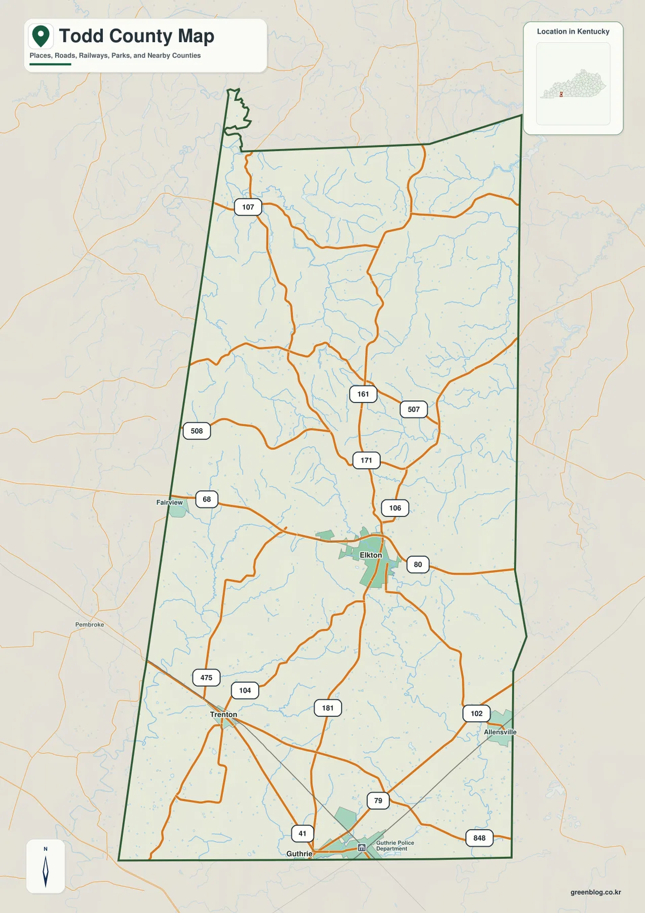
Elkton is the clearest orientation point on the general county map. KY 68 approaches from the west near Fairview and continues through the Elkton area, while KY 80 extends eastward. KY 181 runs south toward Guthrie, and KY 106, KY 171, and KY 161 form a sequence of north-south connections above Elkton. These routes do not merge into a single intersection, but their close spacing around the county seat makes Elkton the easiest place to begin tracing movement across Todd County.
Trenton occupies the southwestern part of the county near KY 104 and KY 475. Roads from Trenton connect eastward toward the central corridor and southward toward the state line. Guthrie lies farther south, where U.S. 41, KY 79, and KY 848 appear near several rail lines. The combination of highway and railroad symbols gives Guthrie a different map character from Elkton: it is not the county’s administrative center, but it is a conspicuous transportation location at the southern edge.
Allensville appears east-southeast of Elkton near KY 102, while Fairview sits close to the western boundary along KY 68. The northern half has fewer prominent settlement labels and more roads such as KY 107, KY 161, KY 507, and KY 508. Many northern routes bend repeatedly instead of following long straight courses. The elevation map helps explain this difference because the north contains more tightly spaced hills and stream-cut valleys than the lower southern part of the county.
The county outline is elongated from north to south and is not a simple rectangle. A narrow projection is visible near the northwest, while the southern edge aligns with the Tennessee border. Christian County lies to the west, Logan County to the east, and Muhlenberg County to the north. These surrounding county labels are useful for regional orientation, especially when explaining why Guthrie is at the southern edge and why the northern road network reaches into a broad rural area without a comparably large town.
This general map is not a live traffic or navigation product. It does not show current construction, congestion, closures, or turn-by-turn directions. Its strength is geographic orientation: users can place Elkton, Guthrie, Trenton, Fairview, and Allensville within the county outline and see how the principal numbered roads connect them. For a presentation, starting at Elkton and tracing KY 68 west-east and KY 181 south provides a simple framework before adding the smaller roads.
A simplified city view centered on Elkton, Guthrie, and Trenton
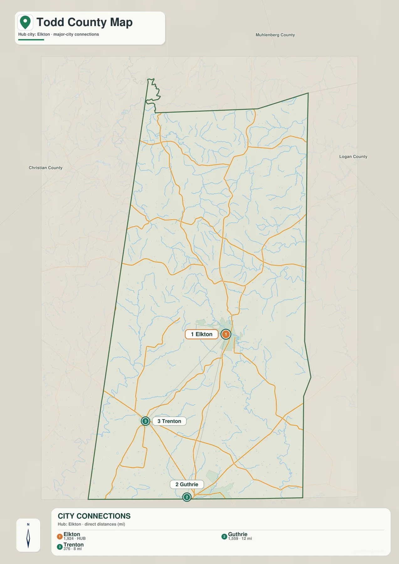
The city-connections map removes much of the road labeling and emphasizes three places: Elkton, Guthrie, and Trenton. Elkton is marked as the hub, Guthrie as the second city, and Trenton as the third. All three are concentrated in the southern half of Todd County, leaving the broad northern area without a comparable city marker. This makes the file especially useful when the goal is to explain settlement geography rather than individual highways.
The connection panel uses straight-line distance from Elkton rather than road mileage. Guthrie is shown roughly 12 miles south of Elkton, and Trenton roughly 8 miles to the southwest. Those values should not be treated as driving distances or travel times, because actual routes follow the road network and may be longer. The direct-distance lines are best understood as a clean visual comparison of where the three cities sit relative to one another.
Guthrie’s location is particularly clear because it sits directly above the Tennessee border. Trenton is northwest of Guthrie and southwest of Elkton, while Elkton forms the northern point of the three-city pattern. Christian County is labeled to the west, Logan County to the east, and Muhlenberg County to the north. These neighboring counties add useful context without cluttering the city map with all of the highway shields seen in the general map.
The small population figures shown in the city index belong to the source data used to create the map and should not be assumed to be the latest official counts. Anyone needing current population totals or demographic details should use the most recent U.S. Census Bureau release. The city map is strongest as an orientation tool: it establishes Elkton as the county-seat reference point and shows that Guthrie and Trenton form the main southern pair.
Pond River tributaries in the north and Red River drainage in the south
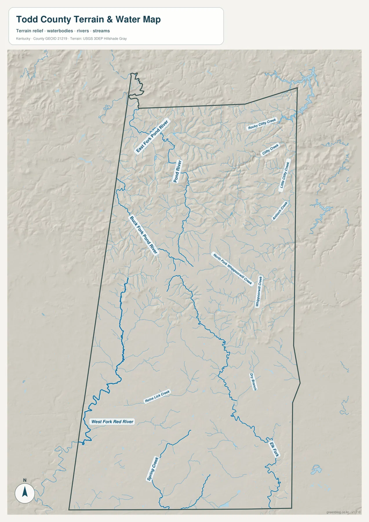
The water map gives northern Todd County a very different appearance from the settlement map. Pond River runs through the north-central area, with East Fork Pond River entering from the northwest side and Buck Fork Pond River following another western valley. Numerous smaller tributaries branch toward these named channels. With shaded relief behind the water lines, the map makes it clear that the northern half is strongly divided by small valleys rather than being one broad flat surface.
Farther east, Rocky Clifty Creek and Clifty Creek occupy the northeastern part of the county. Little Gully Creek and Antioch Creek are labeled near the eastern side, while North Fork Whippoorwill Creek and Whippoorwill Creek appear farther south in the east-central area. These names help organize what would otherwise look like a dense network of thin blue lines. The water map is therefore more useful than the general road map when the question concerns individual stream corridors.
The southern drainage differs from the north. West Fork Red River forms a prominent channel in the southwest, Spring Creek appears near the southern edge, and Elk Fork rises through the southeastern part of the county. Looking at these features together shows that Todd County is divided among several named drainage systems rather than funneling every stream into one obvious central river. That contrast is one of the clearest physical-geography lessons in the map set.
This terrain-and-water file is a reference map, not a flood-risk, depth, water-quality, legal-boundary, or navigation product. A blue stream line should not be used to determine whether a property floods or whether a channel is suitable for boating. For detailed hydrographic work, the USGS National Hydrography datasets and the appropriate state or federal hazard products should be consulted separately. Here, the map is most useful for locating named creeks and comparing their valleys with the surrounding terrain.
122–286 meter relief from the northern hills to the lower southern landscape
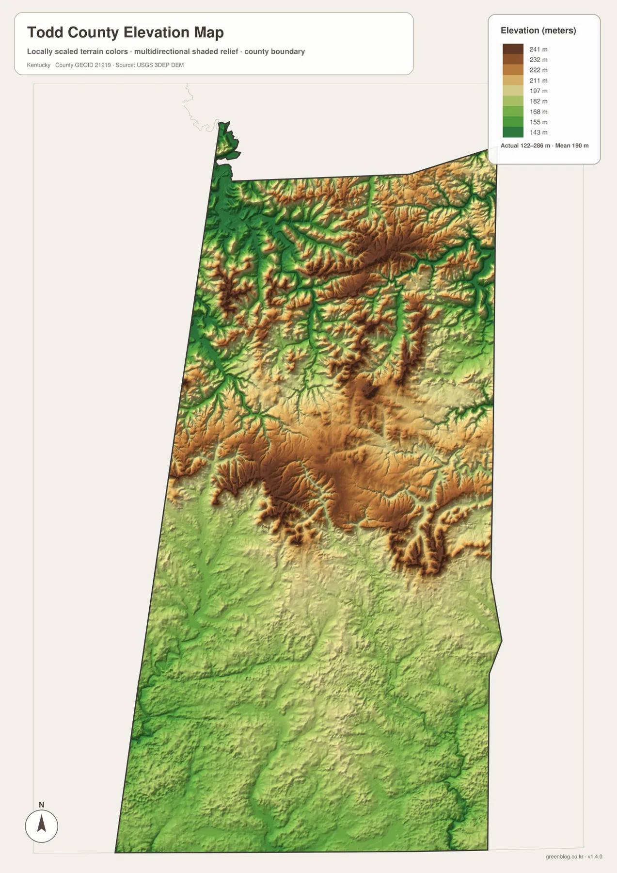
The elevation legend gives an actual Todd County range of roughly 122 to 286 meters, with a mean near 190 meters. Green shades represent lower ground, while tan and brown indicate higher terrain. The broad pattern is immediate: the north and northeast contain more brown ridges and tightly spaced relief, whereas the southern half becomes progressively greener and smoother. Todd County therefore has a notable terrain transition even though its total elevation range is modest compared with mountain counties in eastern Kentucky.
Northern Todd County is not one continuous high plateau. Instead, narrow ridges are repeatedly cut by the Pond River system and its tributaries. The low stream corridors appear as green fingers extending into tan and brown uplands. Around East Fork Pond River, Buck Fork Pond River, and the Clifty Creek system, this pattern is especially easy to compare with the water map. The two files reinforce each other: named blue channels occupy many of the same low corridors highlighted by the elevation colors.
Relief softens through the central part of the county but does not disappear. Whippoorwill Creek and smaller tributaries still occupy visible low corridors around Elkton’s northern and eastern approaches. Farther south around Trenton and Guthrie, lower green terrain spreads across larger areas and the transitions between ridges and valleys are less abrupt. This helps explain why the northern road network appears more sinuous while parts of the southern network can follow longer, more open alignments.
The elevation image is generalized for county-scale interpretation. The approximately 122–286 meter range and mean near 190 meters are useful for comparing broad relief, but they are not parcel-level survey elevations. Construction, engineering, drainage design, and other precise work require higher-resolution source data such as USGS 3DEP products and, where appropriate, professional field measurements. The map should be used to understand regional topography rather than to replace site-specific elevation data.
Connecting the southern city corridor with the northern creek country
Viewed together, the four maps show two broad sides of Todd County. The southern half contains the most visible city and transportation labels: Elkton, Guthrie, Trenton, KY 68, KY 80, KY 181, U.S. 41, and the rail lines at Guthrie. The northern half is visually quieter in settlement terms but far more intricate in physical geography, with Pond River branches, Clifty Creek tributaries, and repeated ridges. This contrast makes the county easy to explain without reducing it to a single road or a single river.
Using Elkton as a reference point, KY 106, KY 171, and KY 161 lead north into increasingly dissected terrain. Southward, KY 181 provides a clearer line toward Guthrie, while KY 68 connects west toward Fairview and the Trenton side of the county and KY 80 continues east. When these routes are mentally overlaid on the water map, many bends and changes in direction make more sense because roads must cross or follow stream valleys rather than ignoring the underlying relief.
A useful presentation sequence begins with the city map to establish Elkton, Guthrie, and Trenton. The general map can then introduce the principal highways and the Tennessee border. Next, the water map can trace Pond River in the north and West Fork Red River in the southwest. Finally, the elevation map shows why the northern channels occupy narrow green valleys between higher ridges while the southern landscape is broader and lower. This order connects human and physical geography without requiring specialized GIS terminology.
Choosing the Todd County file that matches your task
Each file serves a different purpose. The general county map is the best choice when roads, cities, the boundary, and surrounding places need to appear together. The city-connections map is deliberately sparse and is better for explaining the relative positions of Elkton, Guthrie, and Trenton. The terrain-and-water map makes named streams and valley relief clearer, while the elevation image provides the strongest visual comparison between the higher northern hills and lower southern terrain.
- County map: useful for Elkton, Guthrie, Trenton, Fairview, Allensville, KY 68, KY 80, KY 181, KY 79, KY 107, rail lines, and the county outline.
- City map: useful for a simplified view of Elkton as the hub, Guthrie and Trenton to the south, and neighboring Christian, Muhlenberg, and Logan counties.
- Terrain and water map: useful for Pond River, East Fork and Buck Fork Pond River, Clifty Creek, Whippoorwill Creek, West Fork Red River, Elk Fork, and related tributaries.
- Elevation map: useful for comparing the roughly 122–286 meter relief, the higher northern ridge country, and the lower southern half of Todd County.
For a classroom exercise, students can locate Elkton first, follow KY 181 south toward Guthrie, and then compare Trenton to the southwest. Switching to the water map, they can identify Pond River in the north and West Fork Red River in the southwest. The elevation map can then be used to check whether those stream corridors coincide with lower green terrain. This progression turns separate map symbols into a connected explanation of settlement, transport, water, and relief.
The downloadable originals are 3638 by 2572 pixels for each JPG, providing more room to inspect road shields, creek labels, and shaded relief than the smaller web previews. Preserve the original aspect ratio when printing and avoid scaling the files so far down that the water labels become unreadable. Because the four maps emphasize different themes, selecting the file that matches the question usually produces a clearer page or presentation than trying to show every subject at once.
Frequently Asked Questions
Which file shows Elkton, Guthrie, Trenton, and the main roads together?
Use the general county map. It places Elkton, Guthrie, Trenton, Fairview, Allensville, and the Todd County boundary in the same frame with KY 68, KY 80, KY 181, KY 171, KY 161, KY 79, and other numbered roads. If you only need the relative positions of Elkton, Guthrie, and Trenton, the simplified city map is easier to read.
Where are Pond River and West Fork Red River easiest to see?
The terrain-and-water map is the appropriate file. It labels Pond River, East Fork Pond River, Buck Fork Pond River, Clifty Creek, Whippoorwill Creek, West Fork Red River, Elk Fork, and several smaller tributaries. It is a geographic reference map and should not be used as a flood-risk, water-depth, navigation, or legal-boundary product.
Can the 122–286 meter elevation map be used for surveying or construction?
No. The elevation image summarizes broad relief across Todd County and is useful for comparing the higher northern hills with the lower southern landscape. The approximate 122–286 meter range and mean near 190 meters are not survey measurements for a parcel or structure. Engineering, drainage, design, and construction decisions require more precise source data and professional measurements when needed.
Map File Information
The ZIP contains high-resolution JPG versions of the Todd County general map, city map, terrain-and-water map, and elevation map. Use the previews to review Elkton, Guthrie, Trenton, the road network, Pond River drainage, West Fork Red River, and the roughly 122–286 meter relief before choosing the files for your project.
- Included Files: Use only the versions confirmed in the article and supplied images
- File Type: Use the confirmed download contents
- Intended Use: Printing, education, presentations, and map-based projects
Related Maps
Sources and references
The settlement, road, water, and elevation descriptions are based primarily on the supplied Todd County map assets. The following official sources provide additional local and geographic-data context.
- Todd County official website — county information identifying Elkton as the county seat and listing Guthrie and Trenton among Todd County cities.
- City of Elkton official website — municipal information for Elkton, established as the Todd County seat.
- City of Guthrie official website — municipal and community information for the Kentucky-Tennessee border city.
- U.S. Census Bureau TIGER/Line Shapefiles — official geographic resources for county boundaries, roads, and related features.
- USGS National Hydrography — official hydrographic data background for rivers, creeks, and other water features.
- USGS 3D Elevation Program — official U.S. elevation and terrain data program.
Green Map creates custom-edited map images using open geographic data sources such as geoBoundaries, Natural Earth, OpenStreetMap, and government open data. These maps are edited visual materials, not raw data files, and are provided for education, documents, presentations, and graphic reference.