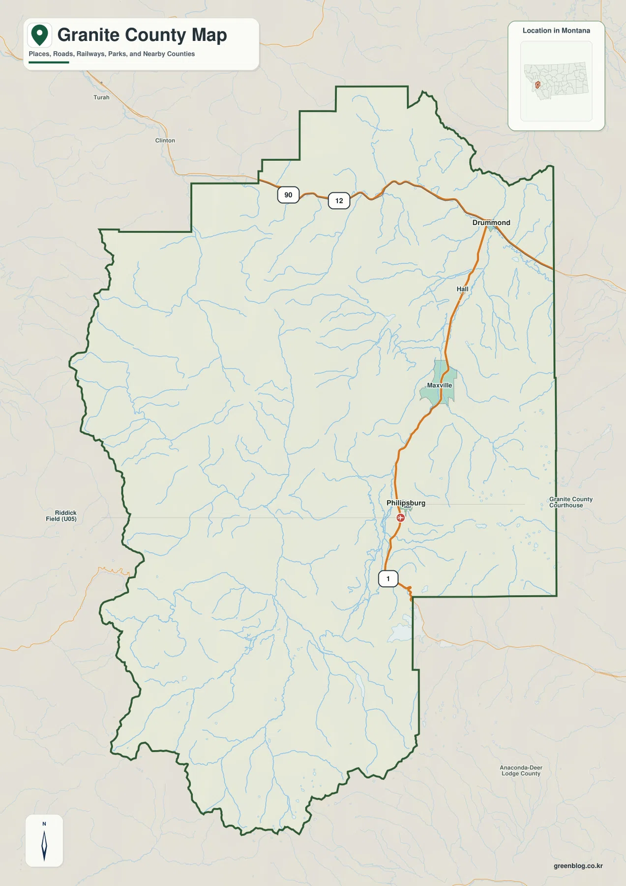
Granite County is a mountain-dominated county in western Montana, with its most recognizable road-and-town corridor running from Drummond south through Hall and Maxville to Philipsburg. Drummond sits near I-90 and U.S. 12 at the northeastern side, while Philipsburg occupies a separate lower valley farther south. Away from that eastern corridor, the county becomes much more rugged: Rock Creek and Upper Willow Creek cut through broad mountain interiors, lakes and reservoirs provide isolated landmarks, and high ridges rise well above 3,000 meters. High-resolution JPG versions of the maps shown here are available together in the download ZIP below.
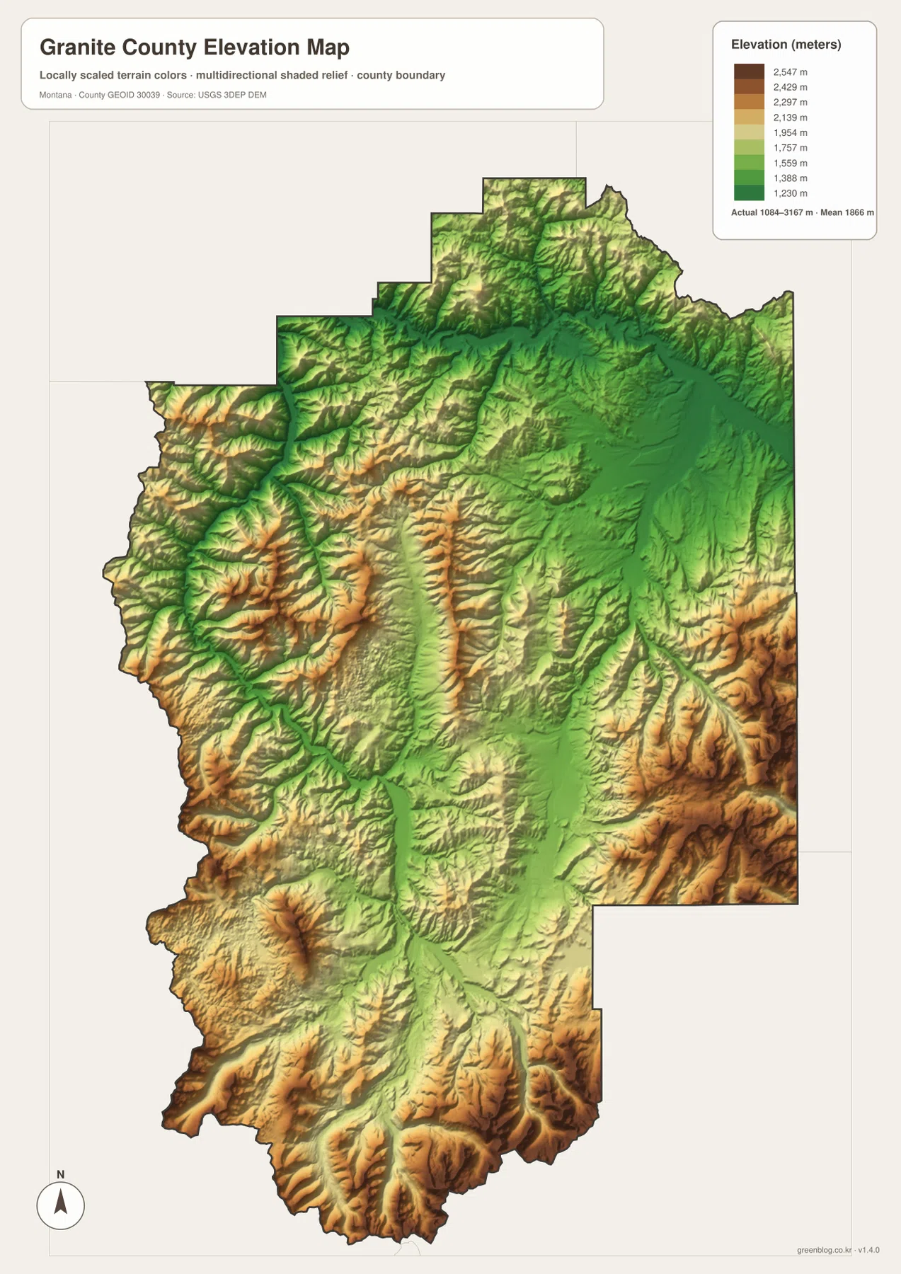
Philipsburg and Drummond provide the simplest starting points, but water features explain much of the county’s physical shape. Clark Fork crosses the north, Flint Creek follows the eastern valley, and Rock Creek branches through the western and southern mountains. The elevation map reinforces that pattern by keeping the major valleys green while the surrounding mountain blocks rise through yellow, orange, and brown.
Table of Contents
MT-1 links Drummond, Hall, Maxville, and Philipsburg
On the general county map, Drummond sits in the northeast near the I-90 and U.S. 12 corridor. From Drummond, MT-1 heads south through Hall and Maxville before reaching Philipsburg. This is the clearest sequence of settlement labels in Granite County and provides an easy framework for understanding the eastern side.
Philipsburg lies farther south and east within a lower valley surrounded by rugged terrain. The map also places Granite County Courthouse near the eastern side and shows Anaconda-Deer Lodge County beyond the southeastern boundary. Those outside labels help establish direction without implying that they are inside Granite County.
The western half contains far fewer major road labels, even though the terrain is crossed by many creek valleys. Static maps are useful for orientation, but mountain-road access, seasonal closures, and forest-road conditions can change and should be checked separately before travel.
Philipsburg and Drummond are the two ranked cities
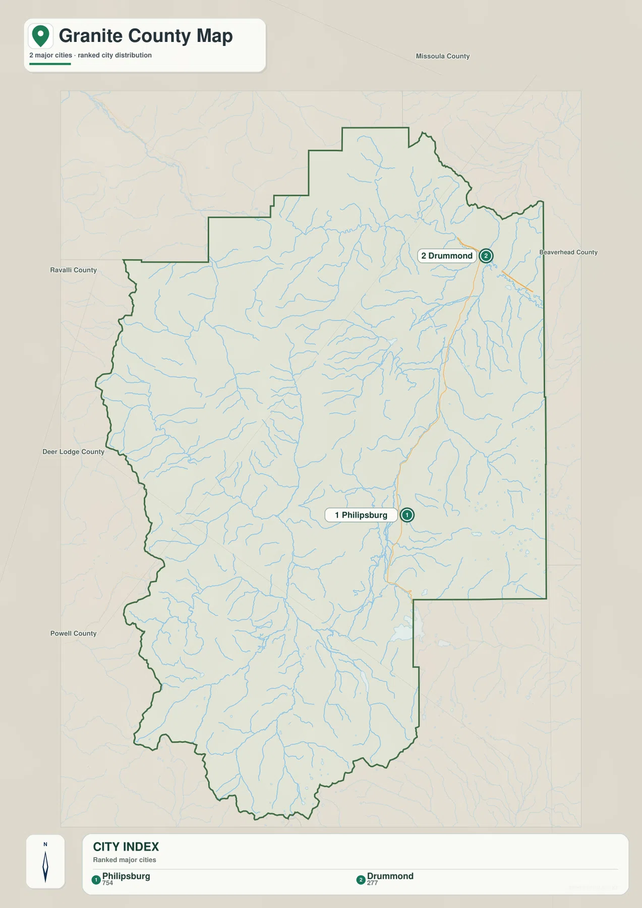
The city map ranks two places: Philipsburg and Drummond. Its printed index shows Philipsburg at 754 and Drummond at 277. Those figures are values embedded in the supplied map and should not be treated as guaranteed current population estimates. Current demographic totals should be checked through recent U.S. Census Bureau data.
Philipsburg appears in the southeastern part of the county, while Drummond lies much farther north and east. Surrounding county labels include Missoula, Ravalli, Deer Lodge, Powell, and Beaverhead counties, which helps place Granite County within western Montana’s mountain region.
No connector line or mileage label is printed between Philipsburg and Drummond. The visual spacing should therefore be treated only as a location reference, not as straight-line distance or road mileage. Actual travel should be checked on the road map and with current navigation information.
Clark Fork and Flint Creek frame the northern and eastern valleys
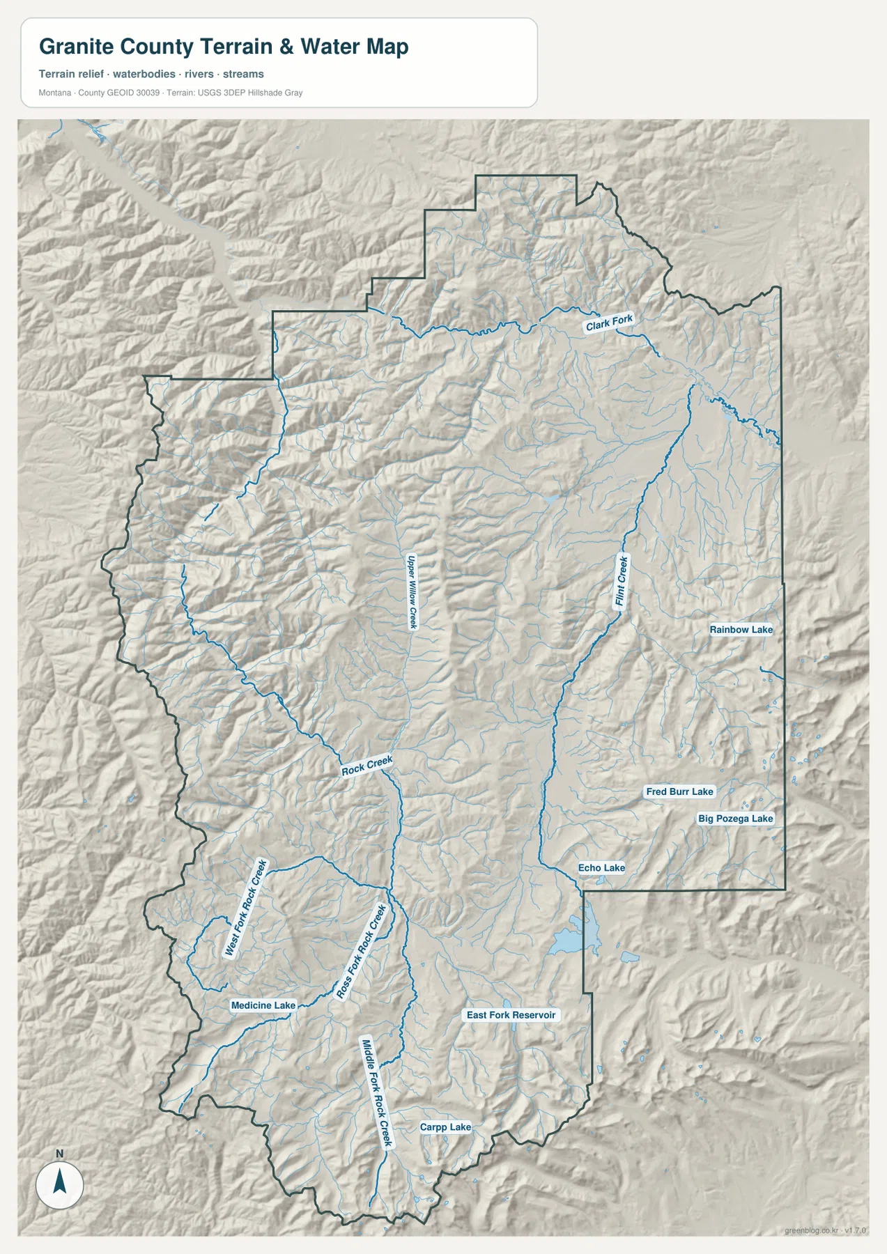
The terrain-and-water map gives Clark Fork a strong role across the northern part of the county. Near Drummond, the river occupies a broad lower corridor that contrasts with the surrounding mountain relief. This northern valley also aligns with the county’s major highway corridor.
Flint Creek runs through the eastern interior toward the Philipsburg side. Numerous smaller tributaries descend from both sides of the valley, and the channel provides one of the clearest natural references for locating Maxville and Philipsburg. Echo Lake, Rainbow Lake, Fred Burr Lake, and Big Pozega Lake appear nearby and help distinguish the eastern mountain basins.
These waterways are useful geographic references, but the map is not a flood-hazard product, navigation chart, parcel survey, water-rights record, or guide to safe stream crossings. Current conditions and property-specific information should be checked through the appropriate official sources.
The Rock Creek system divides the western and southern mountains
Rock Creek is one of the strongest interior drainage features on the map. It crosses the western and central mountain country, while West Fork Rock Creek, Ross Fork Rock Creek, and Middle Fork Rock Creek occupy separate southern valleys. Their similar names make location important, since each fork follows a different mountain corridor.
Medicine Lake provides a useful landmark in the southwest, while East Fork Reservoir lies closer to the southeast-central part of the county. Carpp Lake appears near the southern edge. In a region with few towns and major roads, these named water bodies make it much easier to distinguish one mountain basin from another.
Upper Willow Creek runs through the central interior between the western Rock Creek country and the eastern Flint Creek valley. Comparing these waterways with the shaded terrain shows how deeply the county is divided by ridges and narrow valleys.
Elevation ranges from about 1,084 to 3,167 meters
The elevation map reports an actual county range of about 1,084 to 3,167 meters, with a mean elevation near 1,866 meters. Clark Fork and the Flint Creek-Philipsburg corridor appear in lower green tones. Much of the western, southwestern, southern, and southeastern county rises through yellow and orange into high brown ridges.
The western interior contains repeated north-south ridges separated by low creek valleys. Rock Creek and its forks occupy some of those lower corridors. High terrain also surrounds the southern boundary, while the southeastern edge contains another dense concentration of steep ridges.
Upper Willow Creek and Flint Creek remain visible as lower routes through the mountain terrain. Comparing the water and elevation maps helps explain why settlement and major roads are concentrated in the lower eastern and northern valleys. The elevation map is intended for county-wide comparison only and should not be used as survey-grade or engineering-grade data for a specific property.
Start with the eastern towns, then follow the mountain valleys west
A practical way to read Granite County is to begin with the Drummond-to-Philipsburg corridor. MT-1 connects Drummond, Hall, Maxville, and Philipsburg, while Clark Fork and Flint Creek provide natural references for the same eastern side. Once that framework is clear, the broader mountain interior becomes easier to organize.
Upper Willow Creek is a useful central reference, and Rock Creek with its western and southern forks divides the more rugged half of the county. Medicine Lake, East Fork Reservoir, Echo Lake, and Rainbow Lake then add smaller landmarks within those mountain basins. The elevation map confirms which valleys are lower and which ridges rise sharply above them.
The WebP images embedded in the article are convenient for quick browsing. The high-resolution JPG files in the ZIP are better for printing or enlarging small road, creek, and lake labels. Because these are static reference maps, current road access, water conditions, and seasonal restrictions should be checked through current official information.
Frequently Asked Questions
Does the city map show the distance between Philipsburg and Drummond?
No. The city map ranks and locates Philipsburg and Drummond but does not print a connector line, straight-line distance, or road mileage between them. Use the general county map and current navigation information for an actual trip.
Where is the highest terrain in Granite County?
The highest terrain is concentrated across the western, southwestern, southern, and southeastern mountain areas. The Clark Fork corridor in the north and the Flint Creek-Philipsburg valley in the east are generally much lower.
Can the 1,084–3,167 meter elevation range be used for a property or engineering project?
No. The range is a county-wide reference for comparing lower valleys with high mountain terrain. Precise site elevations should come from an authoritative source such as the USGS 3D Elevation Program and, when necessary, a professional survey.
Map File Information
Download the Granite County county, city, terrain-and-water, and elevation maps as high-resolution A3 JPG files.
- Included Files: county map, city map, terrain and water map, elevation map
- File Type: ZIP containing 4 JPG files
Related Maps
Sources and References
County government information is available from the official Granite County website. Montana Office of Public Instruction also provides a Granite County directory with county and Philipsburg contact information.
Boundary and road-reference data can be checked through U.S. Census Bureau TIGER/Line Shapefiles. Hydrographic data are available from USGS National Hydrography, and elevation data through the USGS 3D Elevation Program.
Green Map creates custom-edited map images using open geographic data sources such as geoBoundaries, Natural Earth, OpenStreetMap, and government open data. These maps are edited visual materials, not raw data files, and are provided for education, documents, presentations, and graphic reference.