Deuel County occupies the southeastern Nebraska Panhandle, where Chappell and Big Springs sit along an east-west transportation corridor between the higher western plains and the lower South Platte River country. Lodgepole Creek enters from the west, while Warpath Draw, Dry Creek, and other drainages descend toward the southeast. The county is compact by Panhandle standards, but its elevation changes enough to make the western uplands and eastern lowlands visually distinct. High-resolution map files are available for download in the section below.
This page explains the positions of Chappell and Big Springs, the main road network, Lodgepole Creek and South Platte River drainage, canals and draws, and an elevation range of about 1,022 to 1,238 meters. The original high-resolution JPG versions of the supplied maps can also be downloaded together in a ZIP for printing, classroom use, or personal reference.
Table of Contents
Chappell and Big Springs grew along the same railroad corridor
Chappell is the Deuel County seat. History Nebraska records that the townsite was platted along the Union Pacific Railroad in 1884 and received a post office in 1886. After several county-seat elections and legal disputes, Chappell was declared the official seat of county government in 1894.
Big Springs lies near the eastern side of the county and shares the same general railroad and U.S. 30 corridor. Union Pacific reached Big Springs in June 1867 and the Chappell area in July of that year. The close relationship between towns, rail line, and the low east-west valley is still obvious on the present map.
Deuel County was formed when old Cheyenne County was divided in November 1888 and was organized in early 1889. Its northern portion later became Garden County, leaving Deuel as the smallest county in the Nebraska Panhandle. The modern boundary is therefore relatively narrow north to south but stretches a much greater distance east to west.
U.S. 30 and I-80 organize the east-west corridor while U.S. 385 crosses Chappell
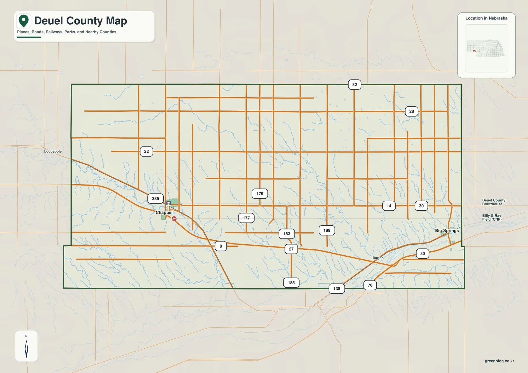
U.S. 30 and I-80 are the clearest east-west transportation references. From Chappell toward Big Springs, rail and highway routes follow broadly similar directions through the southern part of the county. Farther east, this corridor approaches the lower South Platte River landscape.
U.S. 385 provides the main north-south reference through Chappell. The map also shows numbered local and state routes such as 22, 32, 28, and 14 across the northern half, with additional numbered roads including 8, 27, 76, and 138 farther south. Central routes marked 177, 179, 183, and 189 provide useful local orientation across the rural interior.
The road pattern reflects the terrain. The western and northwestern side is higher and more cut by draws, while the Big Springs and South Platte side is lower and broader. The county map is useful for orientation, but current construction, closures, unpaved segments, and actual driving time should be checked with live Nebraska transportation information.
The city map compares Chappell and Big Springs without distance lines
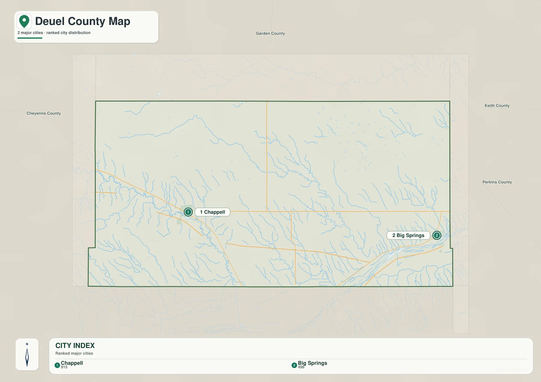
The city distribution map ranks Chappell first and Big Springs second. Chappell lies in the western half near the main rail-and-road corridor, while Big Springs is close to the eastern edge. A broad stretch of rural land separates the two communities even though both are associated with the same east-west transportation system.
No connector line or mileage label appears on the supplied city map. The useful comparison is therefore positional rather than numerical. Use the general road map to understand how U.S. 30 and the railroad connect the two towns, and use a current routing service when actual driving distance or travel time is needed.
The values printed on the supplied map are 915 for Chappell and 496 for Big Springs. They belong to the ranked-city graphic rather than a continuously updated demographic table. Current population figures should be checked with the U.S. Census Bureau or another authoritative source when needed.
Lodgepole Creek and long draws descend toward the South Platte
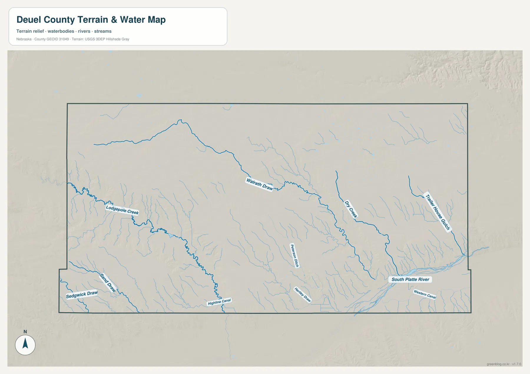
Lodgepole Creek is the most recognizable drainage in the western half. It enters from neighboring Cheyenne County, passes through the Chappell area, and continues southeast through a lower valley. The same corridor carried historic overland transportation and later the railroad, so the creek is useful for understanding both physical and human geography.
Warpath Draw crosses the north-central interior on a long southeastward course, while Dry Creek forms another pronounced drainage farther east. Thirty Horse Gulch cuts down through the northeastern side. Numerous smaller tributaries descend from the higher plains and join these larger channels.
The South Platte River occupies the lowest broad terrain along the southeastern edge. Peterson Draw and Kinney Draw appear farther west, while Sand Draw and Sedgwick Draw reach the southwestern side. Highline Canal and Western Canal add managed water features to the map and show the importance of irrigation infrastructure in this dry High Plains setting.
This water map is intended for geographic reference. It does not define flood zones, legal water rights, parcel boundaries, current canal operation, channel depth, navigability, or public access. Those questions require current information from USGS and the responsible water-management agencies.
The county drops about 216 meters from western high ground to the southeast
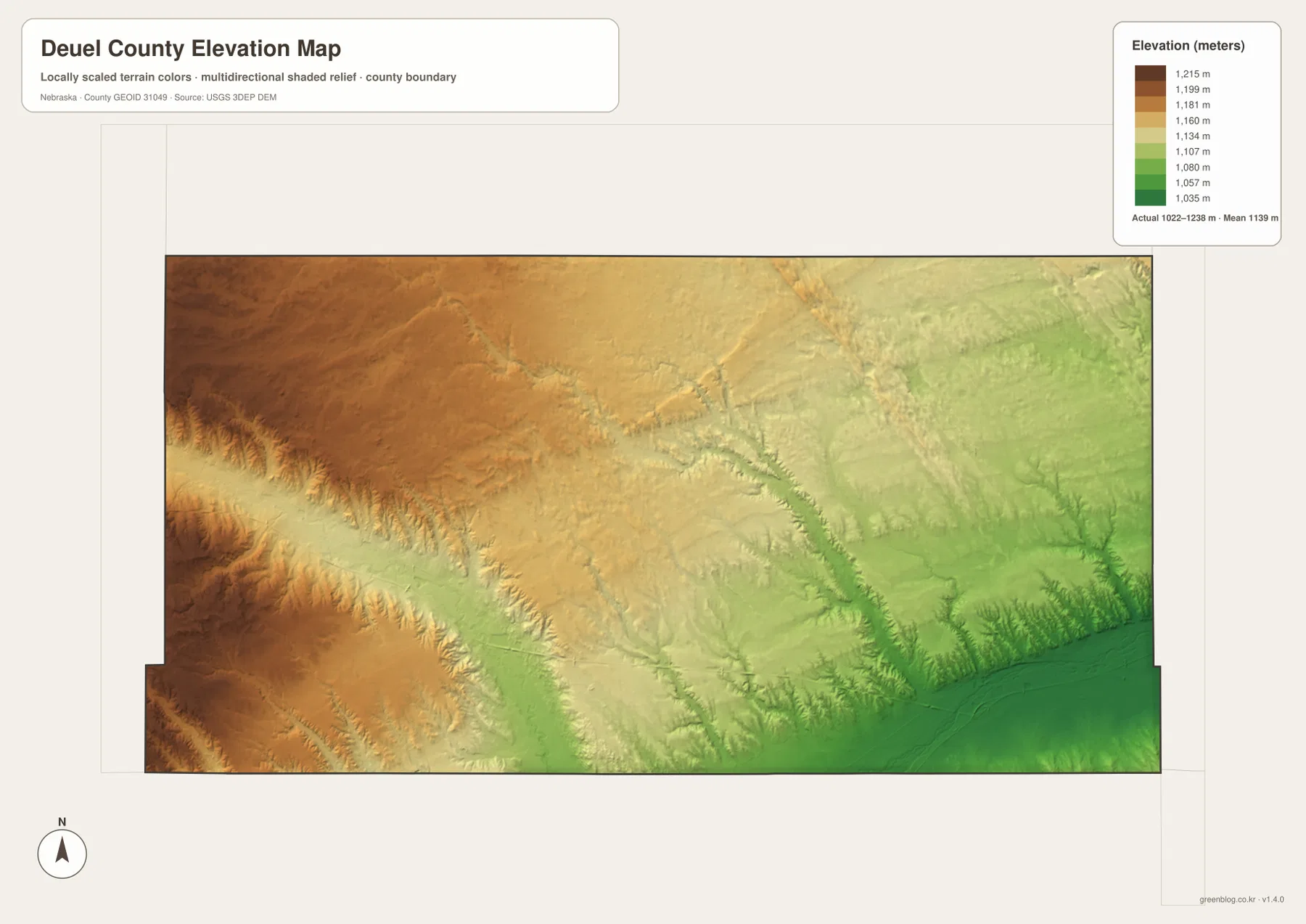
The elevation map reports an actual county-wide range of approximately 1,022 to 1,238 meters, with a mean near 1,139 meters. Browns dominate the west and northwest, while yellow and green terrain becomes increasingly common toward the east and southeast. The difference between the highest and lowest mapped ground is about 216 meters.
Lodgepole Creek appears as a lower green corridor cut into the western uplands. Warpath Draw and Dry Creek create similar low routes through the center, and Thirty Horse Gulch is sharply incised in the northeast. These valleys make the county’s gradual regional slope more complex at the local level.
The broadest low terrain lies around the South Platte River near the southeastern edge. Big Springs is close to this lower side, while Chappell sits farther west on somewhat higher ground. Elevated terrain also persists in the southwest, so the county is not simply one uniform plane sloping in a single direction.
The elevation colors are scaled locally for Deuel County and should be used to compare places within this map. Similar shades on another county map may represent different absolute heights. The generalized surface is not survey-grade information for engineering, construction, drainage design, or property work.
The Lodgepole Creek Valley carried the Pony Express, telegraph, and railroad
History Nebraska’s Lodgepole Creek Valley marker describes this corridor as one of the region’s important nineteenth-century travel routes. The Pony Express used the valley in 1860-1861, and Nine Mile Station stood just southeast of present-day Chappell. The first transcontinental telegraph also followed the valley in 1861.
Stagecoaches later used many of the same stations, and Union Pacific tracks reached the area in 1867. Wagon and stage traffic then declined as rail transportation expanded. Modern highways still follow the same broad east-west corridor, showing how a naturally lower valley continued to guide travel across very different eras.
Railroad land sales shaped Chappell and Big Springs in the 1880s
History Nebraska says Union Pacific began selling land in the Deuel County area in 1884, encouraging permanent settlement. Chappell was platted in August that year, and Big Springs was also laid out by the railroad company in 1884. Both communities therefore developed directly from the same rail corridor that remains visible on today’s map.
The Phelps Hotel in Big Springs is a surviving reminder of that settlement era. A Nebraska historical marker says the 1885 building served travelers, early settlers, church gatherings, and community activities. It is listed on the National Register of Historic Places and connects the small modern town with Deuel County’s railroad-era growth.
Use U.S. 30 and the South Platte as two simple map anchors
For basic orientation, start at Chappell and follow U.S. 30 east toward Big Springs. Then use U.S. 385 through Chappell to understand the north-south road pattern. The city map provides a simplified view of the same two principal communities without smaller road detail.
For physical geography, begin with Lodgepole Creek in the west, then trace Warpath Draw, Dry Creek, and Thirty Horse Gulch toward the southeast before locating the South Platte River. The elevation map explains the same transition with high brown terrain in the west and lower green terrain near the river.
For printing or classroom display, the downloadable high-resolution JPG files preserve more road numbers, draw names, and canal labels than the web previews. The county map emphasizes roads and settlements, the city map compares Chappell and Big Springs, the water map identifies the drainage network, and the elevation map shows the broad west-to-southeast drop.
Frequently Asked Questions
Does the city map show the distance between Chappell and Big Springs?
No. The supplied city map ranks and locates Chappell and Big Springs, but it does not include a connector line or mileage value. Use the general road map for relative position and a current routing service when actual driving distance is needed.
Where is the lowest terrain in Deuel County?
The lowest broad terrain lies near the South Platte River along the southeastern edge. The county-wide elevation range is about 1,022 to 1,238 meters, with higher ground becoming more common toward the west and northwest.
Can the water map be used for flood or water-right decisions?
No. It is a geographic reference showing Lodgepole Creek, South Platte River, Warpath Draw, Dry Creek, and canals. Flood risk, water rights, parcel boundaries, current water conditions, and access questions require current authoritative records.
Map File Information
The ZIP contains the original high-resolution JPG files for the Deuel County boundary and road map, city distribution map, terrain and water map, and elevation map.
- Included Files: Use only the versions confirmed in the article and supplied images
- File Type: Use the confirmed download contents
- Intended Use: Printing, education, presentations, and map-based projects
Related Maps
Sources and references
- History Nebraska – Deuel County Historical Note
- History Nebraska – Chappell Historical Note
- History Nebraska – Historic Lodgepole Creek Valley
- History Nebraska – Phelps Hotel
- USGS National Hydrography
- USGS 3D Elevation Program
These maps are intended for geographic reference. For legal boundaries, land ownership, flood determinations, water rights, road conditions, construction, surveying, or other decisions requiring current authoritative information, consult Deuel County and the responsible state or federal agency.
Green Map creates custom-edited map images using open geographic data sources such as geoBoundaries, Natural Earth, OpenStreetMap, and government open data. These maps are edited visual materials, not raw data files, and are provided for education, documents, presentations, and graphic reference.