Sherburne County lies in east-central Minnesota on the north side of the Mississippi River. A string of communities follows the southern part of the county from Clear Lake through Becker and Big Lake to Elk River, with U.S. 10 providing the clearest road connection among them. U.S. 169 gives the eastern side a second north-south route through Zimmerman and Elk River. The maps on this page separate roads, cities, water, and elevation so each part of the county is easier to understand, and the high-resolution JPG originals can be downloaded together from the file box below. High-resolution map files are available for download in the section below.
The county is not simply a flat rectangle north of the Mississippi. Its southwestern and southern boundary bends with the river, while the interior contains the Elk River, St. Francis River, Snake River, several smaller streams, and lakes such as Briggs Lake, Elk Lake, Rice Lake, and Lake Fremont. The supplied elevation map ranges from about 258 to 338 meters, with lower land along the Mississippi and higher ground appearing in the northwest and along parts of the eastern side. Comparing the four views makes it easier to see how settlement, roads, water, and relief fit together.
Table of Contents
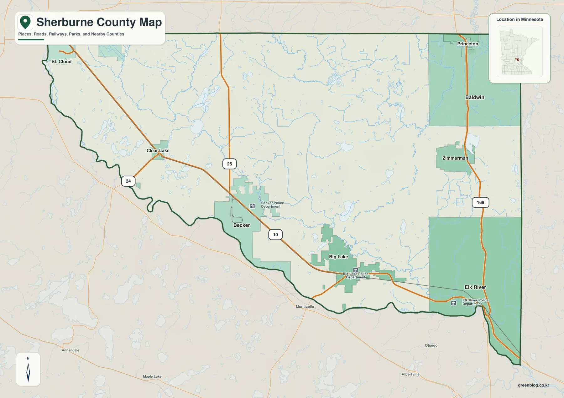
The Mississippi River shapes the southern edge while U.S. 10 links the main towns
The Mississippi River is the best geographic frame for Sherburne County. From the St. Cloud side in the west, the county boundary follows the river south and east in a long series of bends. Clear Lake, Becker, Big Lake, and Elk River all sit north of this boundary, while places such as Monticello appear across the river to the south. The contrast between the winding river edge and the straight northern and eastern county lines gives Sherburne County a recognizable outline and immediately separates the river corridor from the broad interior.
U.S. 10 follows the same general west-to-southeast direction across the populated southern part of the county. It approaches from St. Cloud, passes Clear Lake, continues through the Becker area and Big Lake, and reaches Elk River. This sequence makes U.S. 10 the easiest road to use when explaining the relationship among four of the county’s best-known communities. The road is not directly on the river everywhere, but the cities and highway occupy the same southern band and remain much closer to the Mississippi than Zimmerman or the northern interior.
Other routes organize the county in different directions. Minnesota 25 crosses the central area and meets U.S. 10 near Becker, while Minnesota 24 is visible in the southwest near a Mississippi River crossing. On the east side, U.S. 169 runs north from Elk River through Zimmerman and toward the Princeton area. These roads show why Sherburne County has more than one travel pattern: the U.S. 10 corridor connects the river-side communities, U.S. 169 serves the eastern interior, and Minnesota 25 provides a central north-south reference.
The general map also includes nearby places outside the county, which is useful for orientation. St. Cloud appears just beyond the western edge, Princeton is near the northeastern side, and Monticello lies south of the Mississippi. Those labels make it easier to understand where Sherburne County sits between larger regional destinations without treating the map as a real-time navigation product. Current construction, closures, and travel times can change quickly, so this map is best used for geographic context and should be paired with a current road service when planning a trip.
Elk River and Big Lake anchor the southeast, while Zimmerman stands farther inland
The city view simplifies the background and emphasizes six ranked places: Elk River, Big Lake, Zimmerman, Becker, Clear Lake, and Baldwin. Elk River is shown as the largest of the group, with Big Lake second and Zimmerman third. The numbers printed in the map index belong to the source snapshot used for the graphic, so they should not be treated as a substitute for the newest population estimates. Their main value here is showing relative scale and making the county’s southern and eastern settlement pattern easier to compare.
Elk River occupies a particularly important position because it sits close to the Mississippi River and near the meeting of U.S. 10 and U.S. 169. Big Lake is west of Elk River along U.S. 10, and Becker is farther west on the same corridor. Clear Lake continues the sequence toward the St. Cloud side. These four places form a readable chain across the lower part of Sherburne County, and the city map makes their spacing clearer by removing much of the road and terrain detail.
Zimmerman differs from that river-side pattern. It lies well north of Elk River along the U.S. 169 side of the county, placing it closer to the eastern interior than to the U.S. 10 chain. Baldwin is shown farther north, and Princeton appears beyond the county in the northeast on the general reference map. This separation is useful when explaining that Sherburne County’s population is not arranged in one continuous line. A strong southern corridor is joined by communities that extend northward through the eastern part of the county.
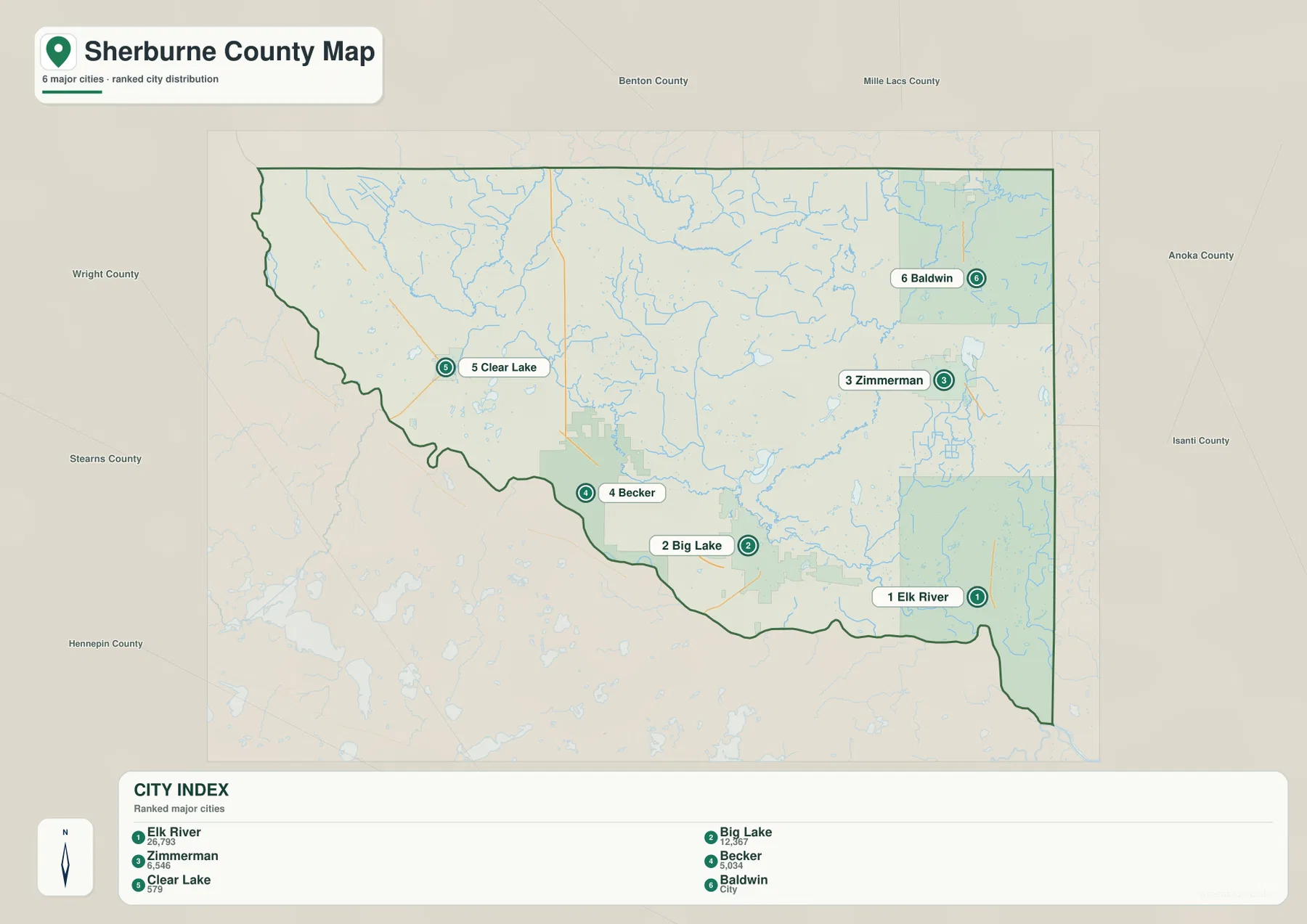
The city map works best when the question is simply where the main communities are and how far apart they appear. If the goal is to explain why Becker and Big Lake feel connected, the U.S. 10 route on the general map provides the missing context. If the goal is to compare Zimmerman with Elk River, U.S. 169 becomes more important. Using the simpler city view first and then returning to the road map keeps the explanation clear and avoids asking one graphic to carry every highway, stream, and terrain label at the same time.
The Elk River and St. Francis River divide a lake-rich interior
The terrain-and-water map reveals a much more detailed interior than the road map suggests. The Mississippi River remains the dominant southern reference, but the Elk River descends through the western half of the county toward the river corridor. Rice Creek appears near it, and Briggs Lake and Elk Lake provide clear lake landmarks in the same broad area. Long Lake is labeled near the southwestern side. Together these features show that the western interior contains a mixture of streams and small lake basins rather than a single open plain.
Farther east, the St. Francis River becomes the strongest named watercourse. It bends through the central and eastern interior, with Rice Lake nearby. The map also labels the Snake River in the central area and Battle Brook and the Rum River near the northeast. Lake Fremont provides an important eastern lake reference, while Eagle Lake and the Eagle River appear toward the southeast. The distribution of these names makes clear that Sherburne County’s water network is spread across several subareas instead of being concentrated only along the Mississippi River.
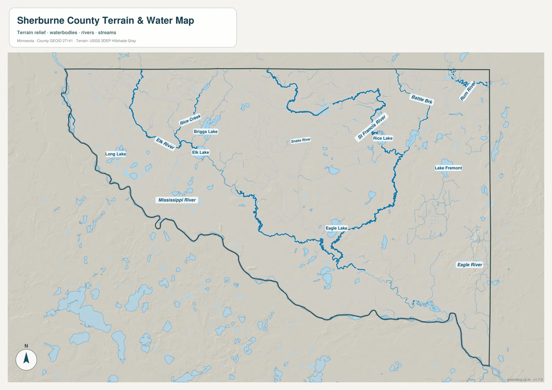
The Elk River area is especially useful for comparing the water and city maps because the community and river share the same name. The river approaches the Mississippi in the southeastern part of the county, while the city of Elk River is also the point where the two major U.S. highways on the map come together. Around Becker and Clear Lake, Briggs Lake, Elk Lake, and Rice Creek provide different water references. Near Zimmerman, the St. Francis River and Lake Fremont are more relevant. The closest named water feature therefore changes noticeably as the reader moves from one community to another.
This layer is a geographic water reference rather than a flood, navigation, water-quality, or property-access map. A blue river or lake outline does not indicate whether a particular parcel floods, whether a shoreline is public, or whether boating is allowed. Those questions require current specialized information from the responsible agency. For this page, the map is most useful for showing where major named waters lie, how rivers occupy different parts of the county, and how the Mississippi River relates to the internal network.
Low Mississippi River ground contrasts with higher northwest and eastern terrain
The elevation map reports an actual range of about 258 to 338 meters and a mean near 297 meters. The broadest low area appears along the Mississippi River, where green colors follow much of the southern boundary. Lower terrain is also visible near the southeastern corner around the Elk River corridor. Moving inland introduces more yellow and brown, and the northwest contains a wide expanse of higher ground. This difference is large enough to make the river edge stand out even without city or highway labels.
The east side contains another distinctive high area. A long brown band and several isolated higher hills appear near the eastern edge, separated by lower green valleys. Smaller high points are also scattered across the north and center. The map therefore does not support a simple statement that Sherburne County slopes evenly from north to south. A better description is that the major river corridors are lower while higher uplands and local ridges remain in several parts of the interior.
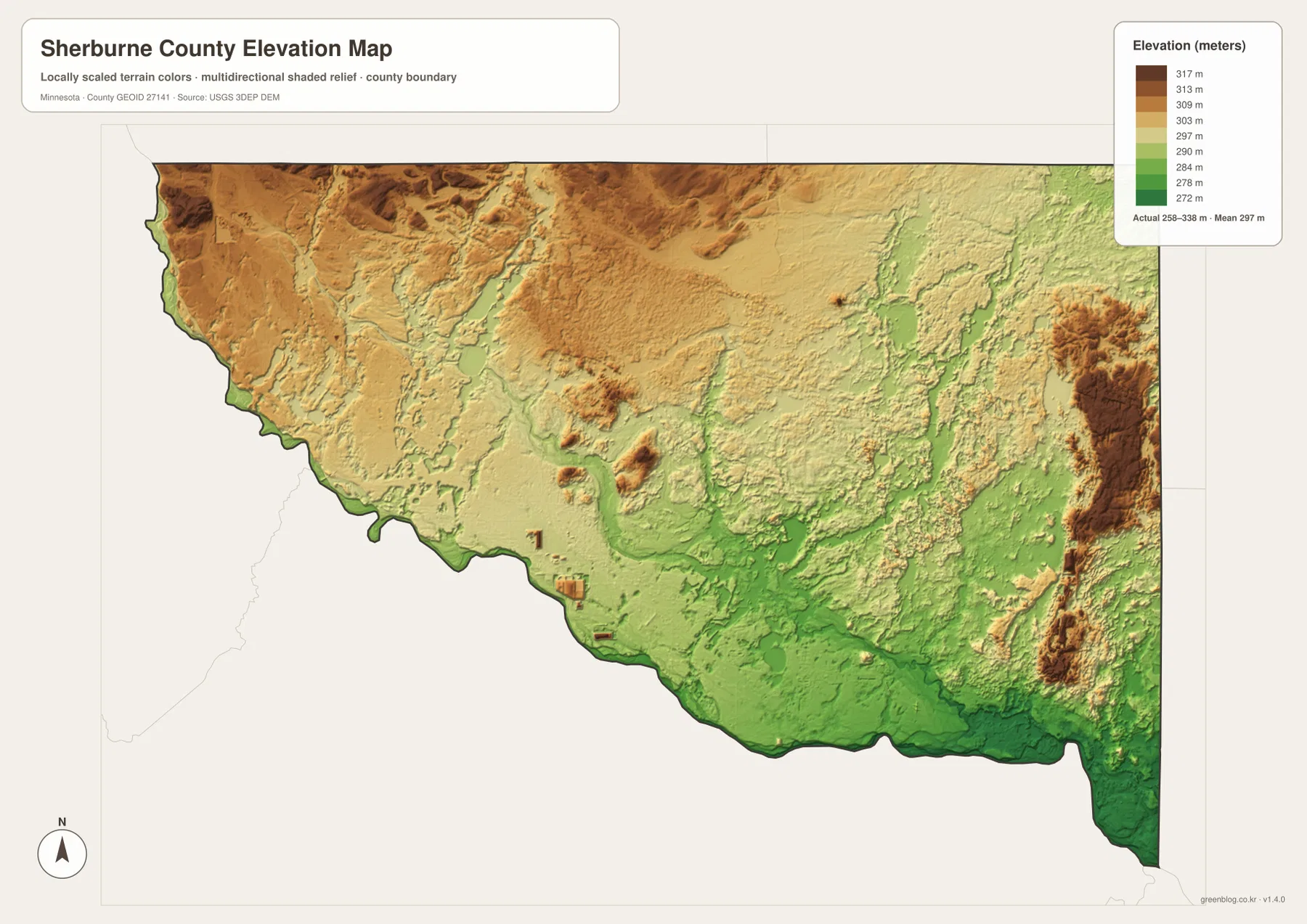
The water map helps explain many of the narrow low corridors inside the county. The Elk River, St. Francis River, and their neighboring streams occupy lower paths between higher surfaces, while several lakes sit in depressions among the rolling terrain. Not every green patch corresponds to a named river, but comparing the two maps shows a repeated relationship between water and lower ground. This is particularly helpful in the eastern half, where high ridges and green valleys alternate more strongly than they do near the broad Mississippi bottomland.
The terrain colors are generalized for countywide comparison and are not survey-grade measurements. They work well for identifying broad high and low areas, comparing river valleys with uplands, and adding physical context to the city and road maps. They should not be used to determine a building elevation, design drainage, establish a legal boundary, or replace professional engineering work. For precise elevations, the USGS 3D Elevation Program or a qualified survey source is the appropriate next step.
Comparing the Clear Lake–Elk River corridor with the eastern interior
The southern corridor from Clear Lake to Elk River is a good example of how the four maps answer different questions about the same place. The general map shows the sequence of towns and U.S. 10, the city map reduces the scene to relative settlement size and spacing, and the water map adds the Mississippi River plus smaller rivers and lakes. The elevation map then reveals that much of this river-side band is lower than the broad northwest and parts of the east. Looking at the same corridor in several ways provides more useful information than repeating a single all-purpose map.
Zimmerman and the eastern interior tell a different story. U.S. 169 is the clearest road reference, Lake Fremont and the St. Francis River are stronger water landmarks, and the terrain map shows a more broken mixture of high ridges and lower valleys. This area is less closely tied to the Mississippi River than the U.S. 10 communities, even though it remains connected to Elk River by the eastern highway corridor. That contrast between a river-oriented south and a more inland east is one of the most useful geographic ideas to take from the map set.
For a first look at the county, start with the general map so the main roads and place names are familiar. The city map is better for a presentation that only needs the relative location of major communities. Use the water map when the question involves the Mississippi, Elk, or St. Francis rivers or the county’s named lakes, and choose the elevation map when the discussion depends on valleys and uplands. The maps complement one another, but each stays clearer when it is used for the type of information it was designed to show.
Sherburne County’s official parks information adds useful real-world context to this landscape. The county describes parks along the Mississippi River and notes that the broader area includes major nature destinations such as Sherburne National Wildlife Refuge and Sand Dunes State Forest. That background fits the map’s combination of river corridors, lakes, wetlands, forests, and open interior land. The maps here do not show every park boundary or recreational facility, so anyone planning a visit should check the current county or agency page for access, closures, and site rules.
High-resolution Sherburne County files for printing and close viewing
The WebP images embedded in the article are optimized for fast page viewing. When small labels need to remain readable in print or on a large presentation slide, the original JPG files are the better choice. The ZIP contains the general county map, ranked city map, terrain-and-water map, and elevation map, all at 3638×2572 pixels. That resolution gives more room for enlargement when comparing highway numbers, smaller river labels, lake names, or the color changes on the elevation surface.
Use the general map when roads, city names, and the county boundary must appear together. The city map is cleaner for settlement distribution, the water map is best for rivers and lakes, and the elevation map provides the clearest view of the 258–338 meter relief. The files work well for classroom material, presentations, printed reference sheets, and personal geographic study. They are not replacements for parcel maps, official engineering plans, flood determinations, legal surveys, or live navigation services.
Frequently Asked Questions
What is the easiest road reference for locating Elk River and Big Lake?
Start with U.S. 10 across the southern part of the county. Big Lake lies along that route east of Becker, and Elk River is farther southeast near the junction of U.S. 10 and U.S. 169. The city map is fastest for comparing their positions, while the general map is better when highway connections and the nearby Mississippi River also matter.
Which rivers and lakes are the strongest landmarks on the Sherburne County water map?
The Mississippi River is the dominant boundary feature, while the Elk River and St. Francis River are the strongest named interior channels. Briggs Lake, Elk Lake, Rice Lake, and Lake Fremont are also useful landmarks in different parts of the county. The water map is meant to show those geographic relationships and should not be used by itself for flood risk, water quality, navigation, or property-access decisions.
Why are the Mississippi River edge and eastern uplands different colors on the elevation map?
The Mississippi River occupies a broad low corridor, so much of the southern edge appears green. Higher ground becomes more extensive inland, with notable high areas in the northwest and along parts of the eastern side. The map legend reports an actual elevation range of about 258 to 338 meters, which is enough to produce a clear countywide contrast between valley bottoms and uplands.
Map File Information
The ZIP contains the original high-resolution JPG versions of the Sherburne County general, city, water, and elevation maps shown on this page.
- Included Files: Use only the versions confirmed in the article and supplied images
- File Type: Use the confirmed download contents
- Intended Use: Printing, education, presentations, and map-based projects
Related Maps
Sources and references
- Sherburne County official overview — county background and local context
- Sherburne County Parks & Trails — Mississippi River parks and natural-area context
- U.S. Census Bureau TIGER/Line Shapefiles — authoritative county boundary, road, and place reference
- USGS National Hydrography — authoritative river, stream, and waterbody reference
- USGS 3D Elevation Program — elevation and terrain reference
Green Map creates custom-edited map images using open geographic data sources such as geoBoundaries, Natural Earth, OpenStreetMap, and government open data. These maps are edited visual materials, not raw data files, and are provided for education, documents, presentations, and graphic reference.