Sibley County occupies a broad piece of south-central Minnesota where an inland farm landscape drops toward the Minnesota River. Gaylord sits near the middle of the county, while Arlington and Green Isle lie to the northeast, Winthrop and Gibbon spread across the west, and Henderson occupies a very different setting beside the river valley on the east. The four maps on this page separate roads, city distribution, water features, and elevation so those relationships are easier to see. High-resolution JPG versions of the same maps are available together in the download box below.
The county is especially easy to recognize from two features. Its eastern boundary follows the winding Minnesota River instead of a straight survey line, and a large notch interrupts the otherwise broad northern side. Inside that outline, MN 5 and MN 22 meet at Gaylord, High Island Creek crosses the northern half, and the Rush River system drains much of the south. The elevation surface adds another strong contrast: western Sibley County is relatively high, while the terrain falls sharply into the river corridor near Henderson.
Table of Contents
A county that steps east toward the Minnesota River
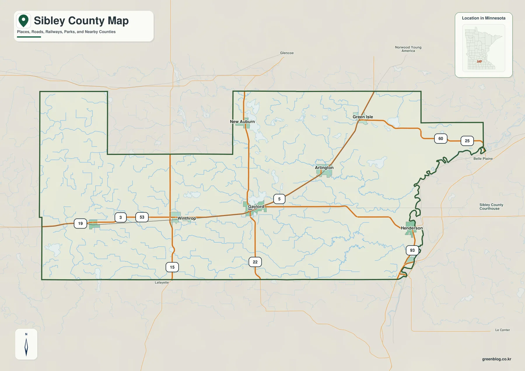
The basic county map is the best place to understand Sibley County’s unusual outline. Long straight segments define much of the west and south, but the eastern edge becomes irregular where the Minnesota River forms the boundary. Near Henderson, the county narrows against a series of river bends before extending northeast toward the MN 25 and MN 60 corridor. The north side also changes shape around a deep rectangular notch, making the county look less like a simple block than many surrounding agricultural counties.
Gaylord provides the clearest inland reference point. MN 5 reaches the city from the east and continues toward Arlington, while MN 22 runs north-south through the same area. MN 19 crosses the western portion through Winthrop and toward Gibbon, and MN 15 touches the southwest. On the far east, MN 93 reaches Henderson and the MN 25/MN 60 route sits near the northeastern extension. These roads do not create one single corridor; instead, they form several smaller connections that link the dispersed towns.
The settlement pattern follows that road network without becoming a continuous urban strip. Gaylord lies centrally, Arlington is northeast of it, and Winthrop and Gibbon occupy the west. New Auburn appears close to the northern edge, Green Isle sits farther northeast, and Henderson is separated from most of the other towns by the transition into the river valley. This makes the county map useful for more than locating communities. It shows why a trip from western Sibley County to Henderson crosses several different landscape settings before reaching the eastern boundary.
This map is intended for regional orientation rather than turn-by-turn navigation. It is useful for seeing which state highway passes near a town, how the county boundary relates to the Minnesota River, and which neighboring places sit just outside the outline. Road construction, closures, and travel times can change, so current transportation information should be checked separately when planning an actual trip. For geographic context, however, the combination of roads, communities, and boundary shape gives a strong first view of Sibley County.
Gaylord acts as the road hinge between Winthrop and Arlington
The city-distribution map removes most road detail and ranks six principal communities from the source used to build the map. Gaylord is shown first, followed by Arlington, Winthrop, Gibbon, Henderson, and Green Isle. The ranking should be treated as part of the map’s own reference data rather than as a substitute for the latest population estimate. Its real value is spatial: the six labels make it immediately clear that Sibley County has several separated town centers rather than one dominant cluster.
Gaylord and Arlington form the strongest central-to-northeastern pair. On the road map, MN 5 links them directly, while the simplified city map makes the distance and direction between the two easier to judge visually. Green Isle sits beyond Arlington to the northeast, so those three places create a stepped pattern across the upper half of the county. New Auburn is visible on the general map but is not part of the six-city index, which is a useful reminder that the city map is selective rather than a complete place-name inventory.
Winthrop and Gibbon form a different western pattern. Both are well away from the Minnesota River, and the county map shows MN 19 as the main east-west reference through that side of the county. Winthrop is closer to Gaylord, while Gibbon sits farther west. Their placement helps explain why western Sibley County feels much broader than the narrow river-edge section around Henderson. When the elevation map is added, this western group also appears on generally higher ground than the communities closest to the river.
Henderson is the outlier among the six indexed places. It lies at the eastern edge rather than in the interior, immediately beside the deeply cut Minnesota River lowland. That location becomes much more meaningful when the water and elevation maps are opened next to the city map. Instead of treating Henderson simply as the fifth ranked place on a list, the maps show it as the community most closely associated with the county’s largest river, steepest local relief, and lowest terrain.
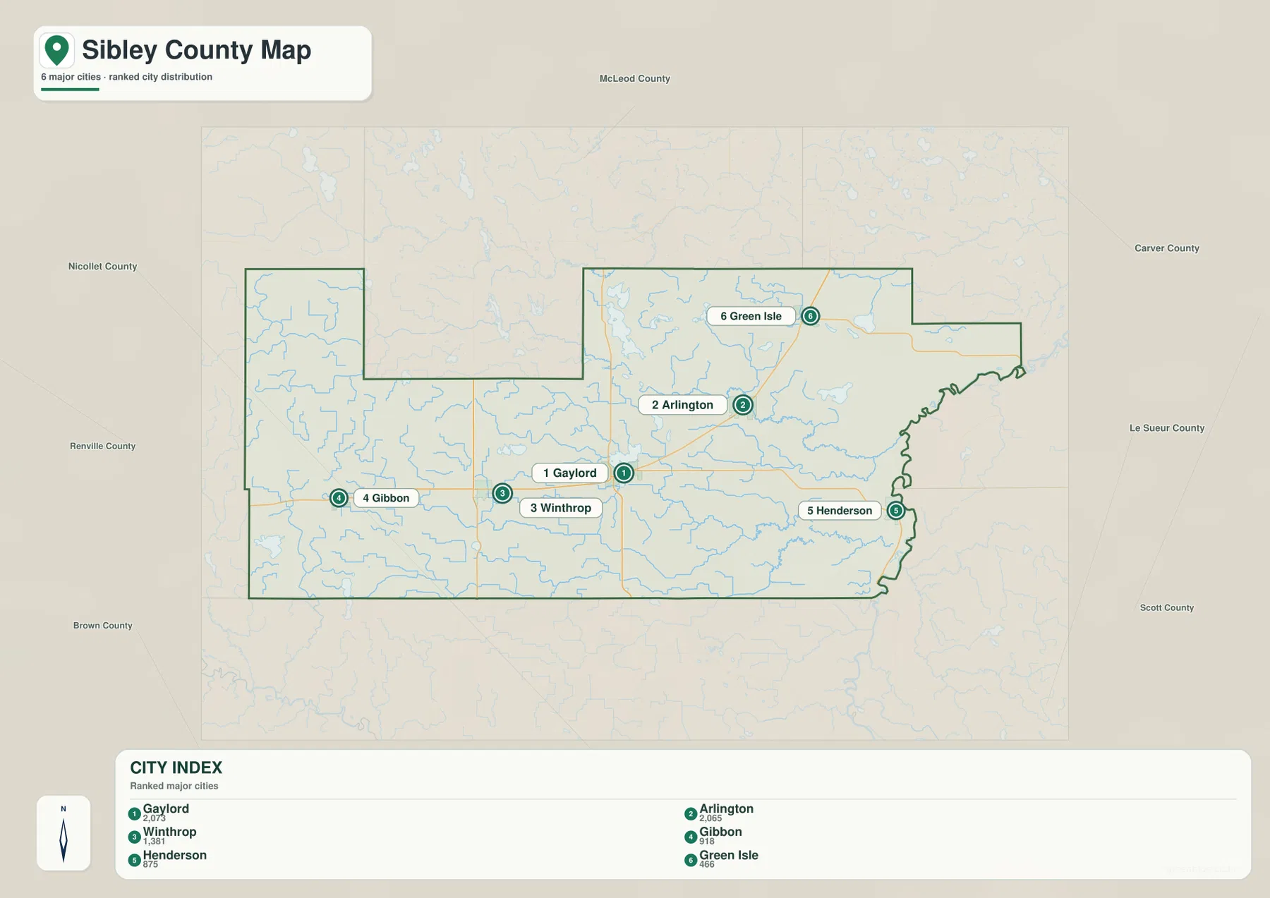
For presentations or classroom material, this simplified map works well when the question is only where the larger towns sit relative to one another. It is less suitable when a reader needs to explain how they are connected, because the road network is intentionally reduced. Pairing it with the county map solves that problem: the city map establishes the spatial pattern, and the road map adds MN 5, MN 19, MN 22, and the eastern routes that connect those locations to the rest of the region.
High Island Creek and the Rush River divide the drainage story
The water map gives northern and southern Sibley County different identities. High Island Creek crosses the northern interior and bends toward the east, while the Rush River and its branches occupy much of the southern half. Both systems ultimately approach the Minnesota River corridor, but they reach it through separate valleys. This pattern is easier to see on the water map than on the general road map because small tributaries are emphasized and the road network no longer competes for attention.
High Island Creek passes through a landscape dotted with several named lakes. High Island Lake and Schilling Lake sit toward the northwest side of that drainage, while Washington Lake and Silver Lake appear farther east. Buffalo Creek is labeled closer to the Minnesota River. Together, these features create a useful chain of reference points across the upper half of the county. They also help explain why the elevation surface contains narrow lower corridors reaching inland from the river valley rather than one continuous flat slope.
The Rush River system is more branched. South Branch Rush River follows the southern part of the county, Middle Branch Rush River comes across the southwest, and North Branch Rush River joins the network nearer the center. The combined Rush River then continues east toward the Minnesota River lowland. Lake Titloe sits north of part of this system, and Swan Lake and Clear Lake are marked near the southwest. These names make the southern half much easier to describe than a generic statement that the county contains many streams.
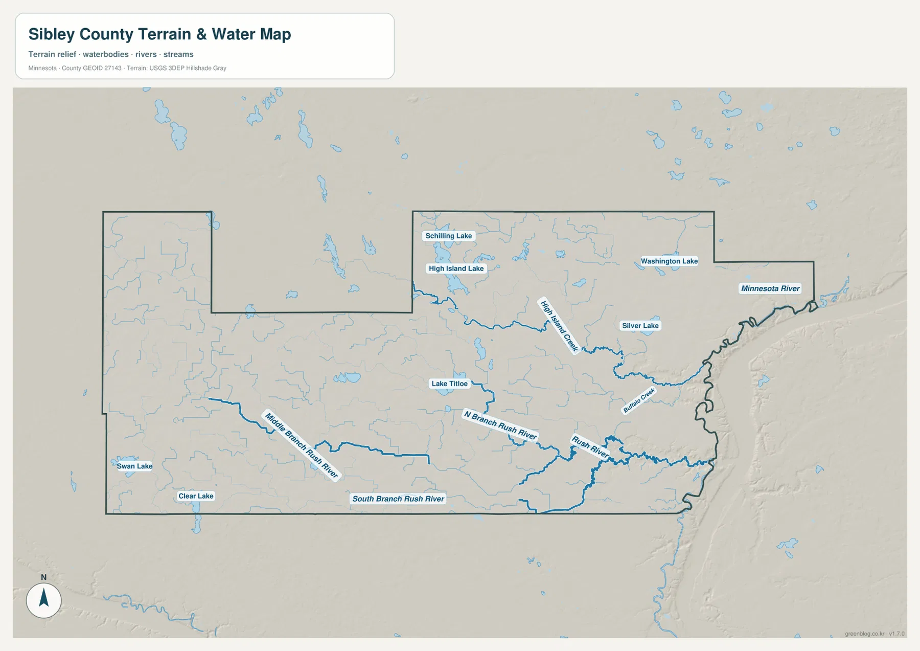
The county’s official park information reinforces the importance of these two drainage names. Sibley County lists both High Island Creek Park and Rush River Park among its park facilities. The High Island Creek Park description notes a creek valley with terrain ranging from gently rolling ground to steep slopes, which fits the relief visible near the eastern drainage network. Those park references add local context, but the map itself should not be used as a park-boundary, flood-risk, water-depth, or navigation product.
Readers interested in the Minnesota River should also keep the scale of the map in mind. It shows the river’s position and its relationship to the county boundary, not current water level, access conditions, or boating hazards. The same caution applies to the smaller lakes and creeks. Their value here is geographic: they explain the shape of the eastern edge, the low valleys cutting into the interior, and the difference between Henderson’s setting and the higher western towns.
The sharpest elevation drop sits beside Henderson
The elevation map labels an actual county range of about 217 to 333 meters, with a mean near 305 meters. Darker brown terrain dominates much of the west, especially the broad southwestern and northwestern interior. The colors become lighter toward the east before turning green in the Minnesota River valley. That change is most dramatic around Henderson, where the low river corridor cuts tightly against higher ground just to the west.
Narrow green and yellow-green corridors extend inland along the same streams seen on the water map. High Island Creek creates one of the clearest northern incisions, while the Rush River branches form lower channels through the south. These valleys are not as low or as broad as the Minnesota River corridor, but they break up the higher upland surface. The result is a county with a high western platform, several interior stream valleys, and a pronounced drop along its eastern edge.
This relief also changes how the towns can be described. Gaylord, Winthrop, and Gibbon sit in the higher interior rather than within the river bottom. Arlington is farther east but still above the deepest Minnesota River lowland. Henderson, by contrast, is immediately adjacent to the lowest green zone. Looking only at the city map would not reveal that contrast, but the elevation layer turns it into one of the county’s clearest geographic patterns.
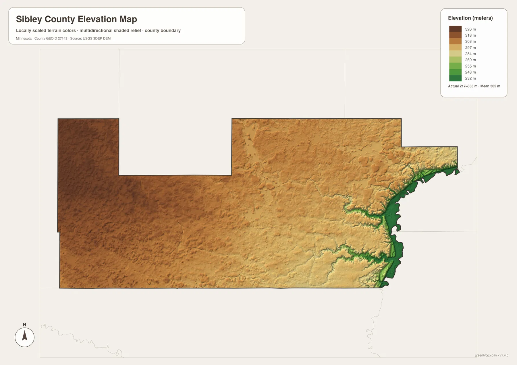
The elevation colors are generalized for county-scale comparison. They are useful for understanding where the landscape is relatively high or low, but they should not be treated as survey-grade measurements for a building site, drainage design, engineering project, or property decision. A precise point elevation requires an authoritative elevation dataset or professional survey. For ordinary map reading, the important message is the regional contrast between the upland interior and the deeply lowered Minnesota River edge.
Choosing the right Sibley County map for the question
The general county map is the strongest starting point when a reader needs one page that combines roads, towns, and the outline of the county. It is especially useful for tracing Gaylord to Arlington on MN 5, finding Winthrop and Gibbon along the western side, or seeing how Henderson sits against the river boundary. Once that framework is familiar, the other maps can answer more focused questions without repeating all the same information.
The city map is best when labels and relative town positions matter more than road detail. The water map should be chosen for High Island Creek, the Rush River branches, the Minnesota River, and named lakes. The elevation map is the clearest option for explaining why Henderson’s landscape differs so much from western Sibley County. A useful workflow for a report is to begin with the general map, add one thematic map that directly supports the topic, and avoid putting all four maps on a page unless the comparison itself is the subject.
The four maps also work well as a sequence. Start with Gaylord and the highway network, switch to the city map to simplify the settlement pattern, use the water map to follow the two major interior drainage systems, and finish with the elevation map to see how those waterways cut into higher ground. That order turns the county from a collection of names into a connected landscape. It also explains why the Minnesota River is not just another blue line on the edge of the map but a major boundary and relief feature.
The WebP images in the article are optimized previews. For printing, close inspection of smaller labels, or use in a presentation, the original JPG files are the better choice. The download archive contains the county map, city map, terrain-and-water map, and elevation map at 3638×2572 pixels each. These files are suitable for general reference and visual explanation, but they are not substitutes for legal boundary records, parcel maps, live navigation, flood determinations, or engineering surveys.
Frequently Asked Questions
Which map makes the Gaylord-Arlington-Winthrop road pattern easiest to understand?
Use the general county map. Gaylord is the central reference, Arlington lies to the northeast along MN 5, and Winthrop is to the west near MN 19. The city map makes the relative town positions cleaner, but it removes the road numbers. For explaining both direction and highway connection, the general map contains the most useful combination of information.
Why does the Henderson area look so different on the elevation map?
Henderson sits beside the Minnesota River valley on the eastern edge of Sibley County. The elevation map shows that corridor in the lowest green colors, while much of the western interior is higher brown terrain. Stream valleys from High Island Creek and the Rush River system also descend toward the same side of the county. The map is appropriate for broad comparison, not for exact site elevations or engineering work.
Which file is best for following High Island Creek and the Rush River branches?
The terrain-and-water map provides the clearest view. It labels High Island Creek across the northern interior and shows the South, Middle, and North branches of the Rush River in the southern half, along with the Minnesota River and several lakes. It is a geographic reference map rather than a flood, depth, access, or navigation chart, so specialized water decisions should use current official sources.
Map File Information
The ZIP contains the high-resolution JPG originals for the Sibley County general map, city map, terrain-and-water map, and elevation map used on this page.
- Included Files: 4 high-resolution JPG maps
Related Maps
Sources and references
- Sibley County official visitor information — county parks and Minnesota River Valley context
- Sibley County High Island Creek Park — local creek-valley and terrain context
- Minnesota DNR Minnesota River State Water Trail — Minnesota River background
- U.S. Census Bureau TIGER/Line Shapefiles — county boundaries, roads, and place reference
- USGS National Hydrography — river, stream, and lake reference
- USGS 3D Elevation Program — elevation and terrain reference
Green Map creates custom-edited map images using open geographic data sources such as geoBoundaries, Natural Earth, OpenStreetMap, and government open data. These maps are edited visual materials, not raw data files, and are provided for education, documents, presentations, and graphic reference.