Jo Daviess County occupies the far northwest corner of Illinois, where the Mississippi River forms a winding western edge and a deeply cut interior rises toward Galena, Elizabeth, Stockton, Warren, and the Apple River country. The maps on this page are designed to make that contrast easy to see. You can follow the county boundary and major roads, compare the positions of the principal mapped communities, trace the Galena, Apple, and Plum river systems, and see the sharp elevation change between the river lowlands and the higher ridges. High-resolution JPG versions of the supplied maps are also available in one downloadable ZIP for closer viewing or print use.
A useful way to orient the county is to begin with U.S. 20. The highway leaves the Galena area, bends southeast through Elizabeth, and continues east toward Stockton. Illinois Route 84 runs through the Hanover and Galena side of the county, while Illinois Route 78 crosses the Stockton area. Farther north, Scales Mound, Apple River, and Warren occupy a different part of the uplands. The result is not a simple pattern of towns spread across a flat grid. Roads and settlements sit among narrow valleys and irregular ridges, while the west side drops toward the broad Mississippi corridor.
The four supplied maps answer different county-scale questions rather than repeating the same design. The general map keeps roads, communities, green areas, streams, and the county outline visible together. The ranked-community map makes Galena, Stockton, East Dubuque, Warren, Hanover, and Elizabeth easier to compare without as much road detail. The terrain-and-water map brings the Galena River, Sinsinawa River, Apple River, South Fork Apple River, Plum River, and smaller tributaries forward. The elevation map then explains the shape beneath those streams, showing low river margins beside a dense network of higher ridges and cut valleys.
Table of Contents
U.S. 20 links Galena, Elizabeth, and Stockton through a rugged interior
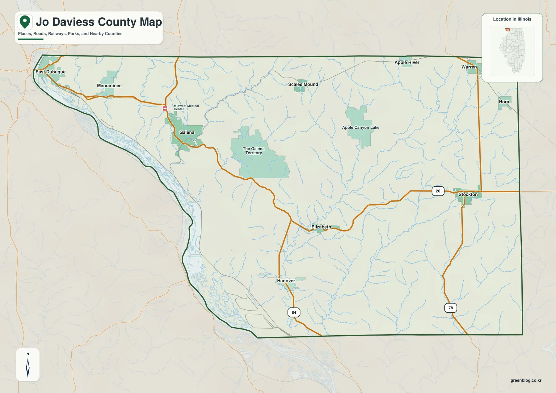
The general map makes U.S. 20 the easiest east-west reference. It leaves the Galena area, curves through the hilly center of the county, reaches Elizabeth, and then continues to Stockton. That route helps separate the western Galena side from the eastern Stockton side without reducing the county to a single straight corridor. East Dubuque sits much farther northwest at the tip of the county near the Mississippi River, while Hanover is southwest of Galena along the Illinois Route 84 side. A visitor who knows only Galena can use these relationships to build a much clearer picture of the rest of the county.
Illinois Route 78 adds another orientation line on the east. It runs through the Stockton area and continues north-south near the eastern county boundary. Warren and Nora appear farther north, and Apple River and Scales Mound are labeled across the northern interior. Those places are not arranged around one central hub. Instead, communities spread across several valleys and upland sections, so travel direction changes depending on whether the destination is along the Mississippi side, the U.S. 20 corridor, or the northern and eastern high country.
The map also marks The Galena Territory and Lake Galena east of Galena, with Apple Canyon Lake farther to the east. These green areas and water features provide useful landmarks because they occupy much larger spaces than the compact community symbols. They are especially helpful when reading the county at a small scale: Galena appears as a built-up place near the western valleys, The Galena Territory covers a broad interior area, and Apple Canyon Lake gives another recognizable point before the map reaches Stockton and the eastern edge.
Jo Daviess County’s western boundary looks very different from its eastern side. From East Dubuque south toward the Hanover area, the line bends with the Mississippi River and adjacent lowlands. Much of the east side is considerably straighter, and parts of the north and south boundaries also follow regular administrative lines. That combination is important because it prepares the reader for the specialized maps: the west is shaped by a major river corridor, while the interior is divided by smaller valleys and ridges that do not necessarily appear in the county outline itself.
Official county background material connects the early growth of Jo Daviess County closely with Galena and the lead-mining era along the Galena River. The modern map still makes Galena a strong western reference point because roads, the Galena River valley, and nearby developed areas converge there. This page is not a street-by-street historic map, but that county history helps explain why Galena is more than an isolated label on the west side. Readers interested in the historical detail can follow the Jo Daviess County government source linked at the end of the article.
Six mapped communities show how widely settlement is spread
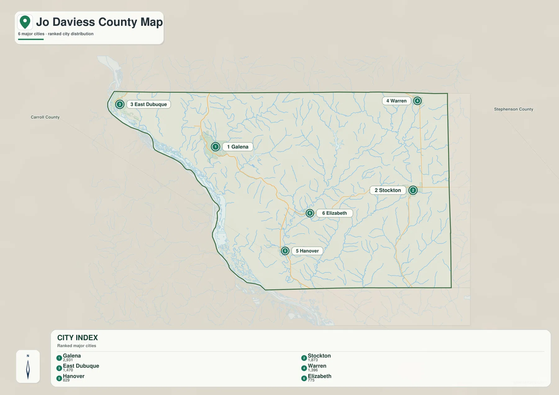
The community map removes much of the road clutter and makes the county’s settlement pattern immediately visible. Galena is in the western interior, East Dubuque is near the northwestern river edge, Stockton stands in the eastern half, and Warren is close to the northeastern boundary. Elizabeth occupies a more central-southern position, while Hanover is farther southwest. None of these six places sits in a single tight cluster with the others, which is why the county can feel much larger and more varied than a simple list of town names suggests.
The index printed on the supplied image lists Galena at 2,931, Stockton at 1,873, East Dubuque at 1,470, Warren at 1,396, Hanover at 829, and Elizabeth at 775. On this page, those numbers are best treated as map labels for comparing the relative size of the six selected communities, not as a substitute for a current demographic table. Population estimates change, and municipal classifications are more detailed than a simple ranked map can show. The map’s strength is positional: it makes it easy to see which communities are west, east, north, or south of one another.
Galena and East Dubuque demonstrate that even the western side contains two different settings. East Dubuque occupies the narrow northwestern end of the county close to the Mississippi River, whereas Galena sits farther southeast in the Galena River valley. Across the county, Stockton and Warren are far removed from the Mississippi edge and belong to the eastern and northeastern interior. That contrast is useful for anyone planning a county overview because “western Jo Daviess County” can refer to both a major river border and a network of inland valleys.
Elizabeth and Hanover clarify the southern pattern. Elizabeth lies on the U.S. 20 corridor closer to the center of the county, while Hanover is much farther southwest near the Route 84 side and closer to the broad Mississippi lowlands. Moving east from Elizabeth leads toward Stockton and higher interior terrain; moving west and south from Hanover approaches the river side. A classroom map, local-history handout, or travel-orientation page can use this simplified community view when the full road network would distract from those basic relationships.
The outer labels for Carroll County and Stephenson County also help with orientation. They remind the reader that several towns near the Jo Daviess boundary connect outward as well as inward. This map is not intended for turn-by-turn navigation or municipal boundary research, but it is a clean way to understand where the county’s better-known communities sit before returning to the road, water, or elevation maps for more detail.
The Galena and Apple river systems carve separate networks of valleys
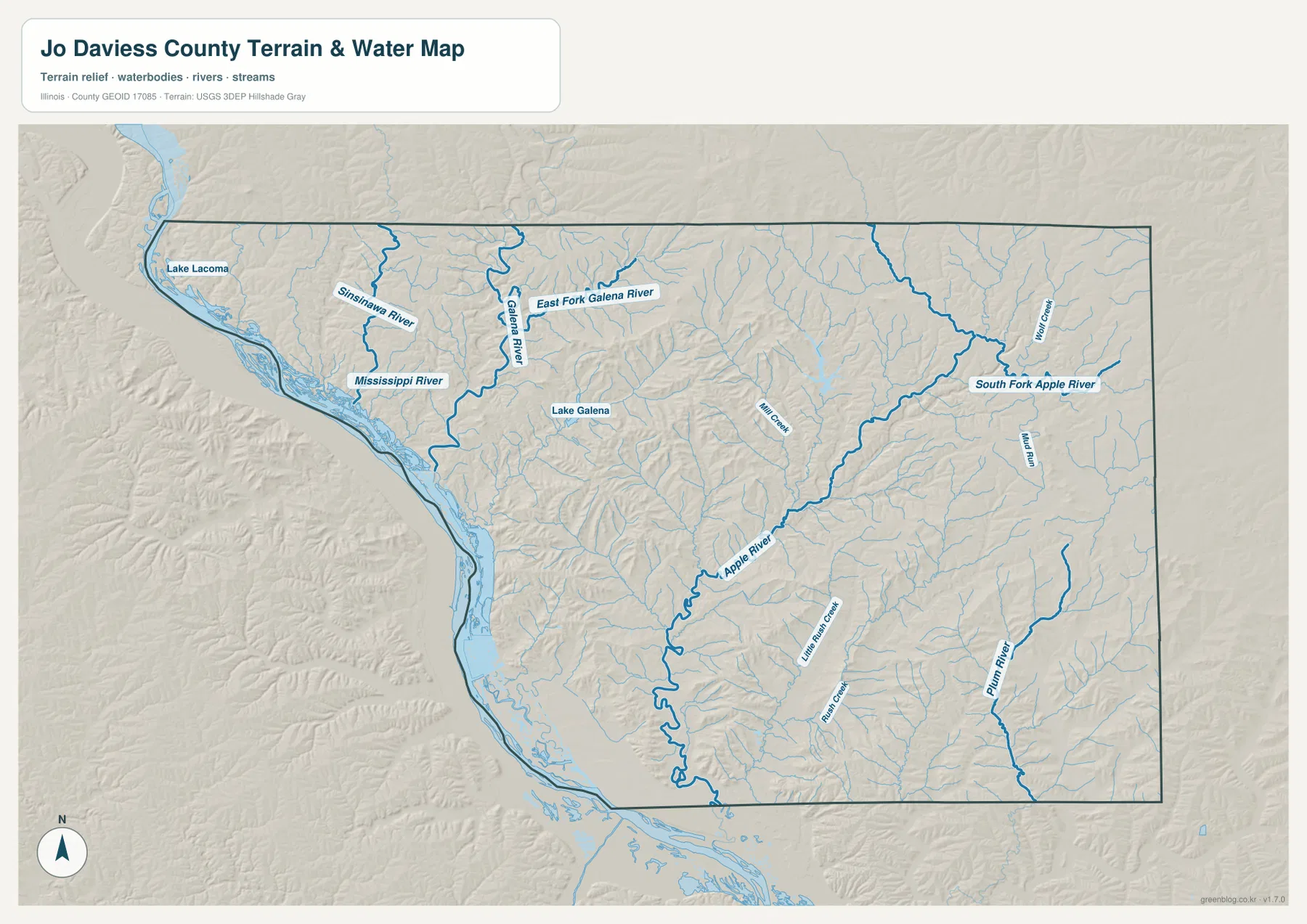
The Mississippi River is the largest water feature on the map, but it does not explain the county’s interior by itself. In the northwest, the Sinsinawa River bends toward the river corridor. Around Galena, the Galena River and East Fork Galena River occupy a separate valley system, with Lake Galena shown nearby. Numerous short tributaries descend toward these channels, and the shaded relief makes the western interior look far more dissected than the general road map suggests.
Farther east, the Apple River becomes one of the most prominent interior waterways. It runs through the middle portion of the county toward the northeast, while South Fork Apple River is emphasized in the eastern section. Wolf Creek and Mud Run are labeled among the smaller northern and eastern streams. Illinois Department of Natural Resources information for Apple River Canyon State Park describes this part of Jo Daviess County as a landscape of limestone bluffs, deep ravines, springs, and streams shaped by the Apple River. The county map does not show park trails, but it does make the broader valley system around the river easy to recognize.
The southeast has another important system. Plum River is clearly labeled near the eastern and southern side, while Little Rush Creek and many unnamed tributaries occupy the central-southern terrain. These waterways show that Jo Daviess County does not drain through one simple fan of streams. The Galena River system, Apple River system, and Plum River occupy different portions of the county, with ridges separating many of their tributaries. Looking at the water map beside the elevation image is especially useful because the larger blue channels generally follow the green, lower valleys between higher ridges.
The western Mississippi corridor is different again. Broad water and low ground extend along the edge, while short valleys drop steeply from the interior hills toward the river. Some sections of the lowland widen, then narrow where higher ground approaches the channel. The Galena River reaches toward this western system, but much of the county’s drainage remains separated by interior ridges. That combination of a major border river and several independent inland watersheds is one of the clearest geographic themes in the supplied maps.
This terrain-and-water image is a reference map, not a flood-hazard, navigation, parcel, or legal-boundary product. It does not tell a property owner whether a specific parcel is in a regulatory floodplain, how deep a channel is, or whether boating conditions are safe. Water levels also change over time. Use it to locate named rivers and creeks, compare the river edge with the interior valleys, and understand how streams divide the county. For regulatory or real-time water questions, current agency data should be consulted instead.
Elevation rises sharply away from the Mississippi lowlands
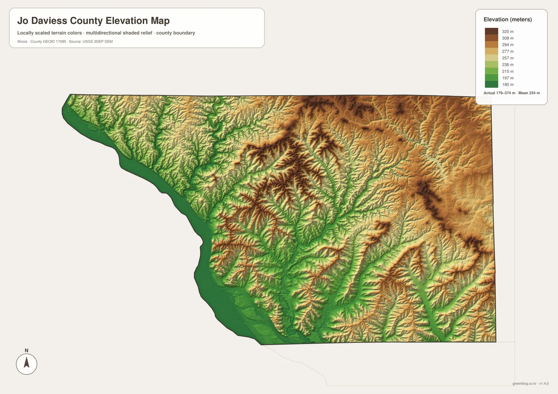
The elevation map makes Jo Daviess County’s relief unmistakable. Its legend shows an actual mapped range of about 179 to 374 meters and a mean near 254 meters. The Mississippi side is mostly green and low, but the land rises quickly into yellow, orange, and brown ridges only a short distance inland. Galena sits within a lower valley cut into surrounding higher ground, and the central county contains a dense pattern of narrow valleys that separate ridge after ridge.
Some of the strongest high-elevation colors appear across the central-northern and northeastern parts of the county. These are not broad, featureless plateaus. Green valleys branch into the higher terrain, creating a repeated ridge-and-hollow pattern. When the Apple River and South Fork Apple River from the water map are compared with the same area on the elevation map, their valleys become much easier to recognize. The Galena River system produces a similar effect on the west, where lower corridors cut through higher surrounding hills.
Illinois DNR describes the Apple River Canyon area as part of the Driftless region, where the glacial processes that flattened many other parts of the state did not erase the older relief. Limestone bluffs, ravines, and exposed valley walls remain characteristic of the northwest. The supplied elevation map is not a geology map, but its irregular ridges and deeply cut valleys match that broader regional description. For readers accustomed to the flatter agricultural landscapes elsewhere in Illinois, this is one of the quickest ways to understand why Jo Daviess County looks different.
The river edge itself is not uniformly flat. Low green areas widen and narrow along the Mississippi, and higher ground sometimes approaches the river closely. As a result, elevation can change rapidly over a relatively short distance. Farther east, the average ground may be higher, yet streams still create long lower corridors through the uplands. A simple statement such as “west low, east high” misses that detail. A better description is a low Mississippi margin connected to many interior valleys, with higher ridges repeatedly rising between them.
The image is intended for regional visual comparison, not engineering or survey work. A color band can show that one area is generally higher than another, but it should not be used to determine the exact elevation of a house, road crossing, or property corner. USGS 3D Elevation Program data is the better source when detailed numeric elevation is required. For this page, the map is most useful for seeing why the Galena, Apple River, and Mississippi sections of the county have such different terrain.
Choosing the clearest map for roads, communities, rivers, or relief
Start with the general county map when the main question is location. It gives the best combined view of Galena, East Dubuque, Elizabeth, Stockton, Hanover, U.S. 20, Illinois Routes 84 and 78, green areas, streams, and the county outline. It is also the most convenient map for explaining how the Mississippi side relates to the eastern boundary. Once that overall orientation is clear, the other maps can answer more specific questions without forcing the reader to interpret every symbol at once.
Use the community map when the relative positions of the six highlighted population centers matter more than road detail. It quickly shows Galena in the west, Stockton in the east, East Dubuque and Warren on opposite ends of the north, and Elizabeth and Hanover across the southern half. The printed ranking values can help compare the selected communities on the supplied map, but up-to-date demographic analysis should use current Census or local sources.
For physical geography, the terrain-and-water map and elevation map work especially well as a pair. First trace the Galena River, Apple River, South Fork Apple River, Plum River, and Mississippi edge. Then switch to the elevation image and look for the same green valleys among the higher ridges. That comparison is more informative than treating the blue water lines and the color relief as separate topics, because the county’s stream network is closely tied to its deeply cut topography.
For classroom handouts, local presentations, or printed reference pages, choosing one or two maps for the specific topic is often clearer than placing all four on one crowded sheet. A road-and-community discussion may need the general and community maps; a lesson on valleys and the Driftless landscape may work better with the water and elevation maps. The web images are sized for convenient on-page viewing. The original JPG files in the ZIP below are the better option when small labels need to remain readable after enlargement or printing.
Each map also has limits. A county boundary is not a parcel boundary, a major-road map does not replace current navigation, a water-reference map is not a regulatory flood map, and a generalized elevation image is not a survey surface. Those limits do not reduce the value of the maps; they simply define the questions each one can answer well. Used at county scale, the set gives a clear picture of a place where historic Galena, eastern uplands, the Apple River system, and the Mississippi lowlands occupy noticeably different landscapes.
Together, the supplied maps show why Jo Daviess County is hard to summarize with a single road line or one famous town. Galena is the best-known western reference, but Stockton, Warren, Elizabeth, Hanover, and East Dubuque spread across very different parts of the county. U.S. 20 crosses the rugged interior, several river systems cut separate valleys, and elevation changes from low Mississippi margins to high interior ridges. That combination gives the county a distinctive shape and terrain that is visible even before a reader moves to more detailed local maps.
Frequently Asked Questions
Which map is best for comparing Galena with Stockton and East Dubuque?
Use the general boundary-and-road map when you want both place names and route context. It shows Galena in the west, Stockton in the east along U.S. 20, and East Dubuque at the northwestern river edge. If road detail is not important, the ranked-community map gives a cleaner comparison of all six highlighted communities.
Does the map include trails inside Apple River Canyon State Park?
No. The supplied terrain-and-water and elevation maps show the Apple River valley and surrounding county-scale relief, but they do not map individual park trails, parking areas, or facilities. Use the Illinois Department of Natural Resources Apple River Canyon State Park page and official park materials for trail-specific planning.
Can the 179–374 meter elevation range be used as survey-grade data?
No. The elevation map is intended for regional comparison. Its legend shows an approximate mapped range of 179 to 374 meters and a mean near 254 meters, which is useful for seeing the low Mississippi corridor and higher interior ridges. Engineering, construction, or property-level elevation work requires authoritative detailed elevation data or professional survey information.
Map File Information
The ZIP contains the original high-resolution JPG versions of the Jo Daviess County boundary-and-road map, ranked-community map, terrain-and-water map, and elevation map. Use the larger files when you need to inspect Galena, U.S. 20, the Mississippi and Apple river systems, or the county’s ridges and valleys more closely or in print.
- Included Files: 4 high-resolution JPG maps
- File Type: JPG images packaged in one ZIP archive
Related Maps
Sources and reference data
The following official sources provide county background or authoritative geographic data related to the features shown on the maps. Use the agency datasets directly when a project requires more detailed or current information than a county-scale reference map can provide.
- Jo Daviess County Government – Community – county and Galena history background
- Illinois Department of Natural Resources – Apple River Canyon State Park – Apple River, limestone bluffs, ravines, streams, and Driftless-region background
- U.S. Census Bureau TIGER/Line Shapefiles – county boundaries and related geographic framework
- USGS National Hydrography – authoritative river and stream data
- USGS 3D Elevation Program – elevation source data
Green Map creates custom-edited map images using open geographic data sources such as geoBoundaries, Natural Earth, OpenStreetMap, and government open data.
These maps are edited visual materials, not raw data files, and are provided for education, documents, presentations, and graphic reference.