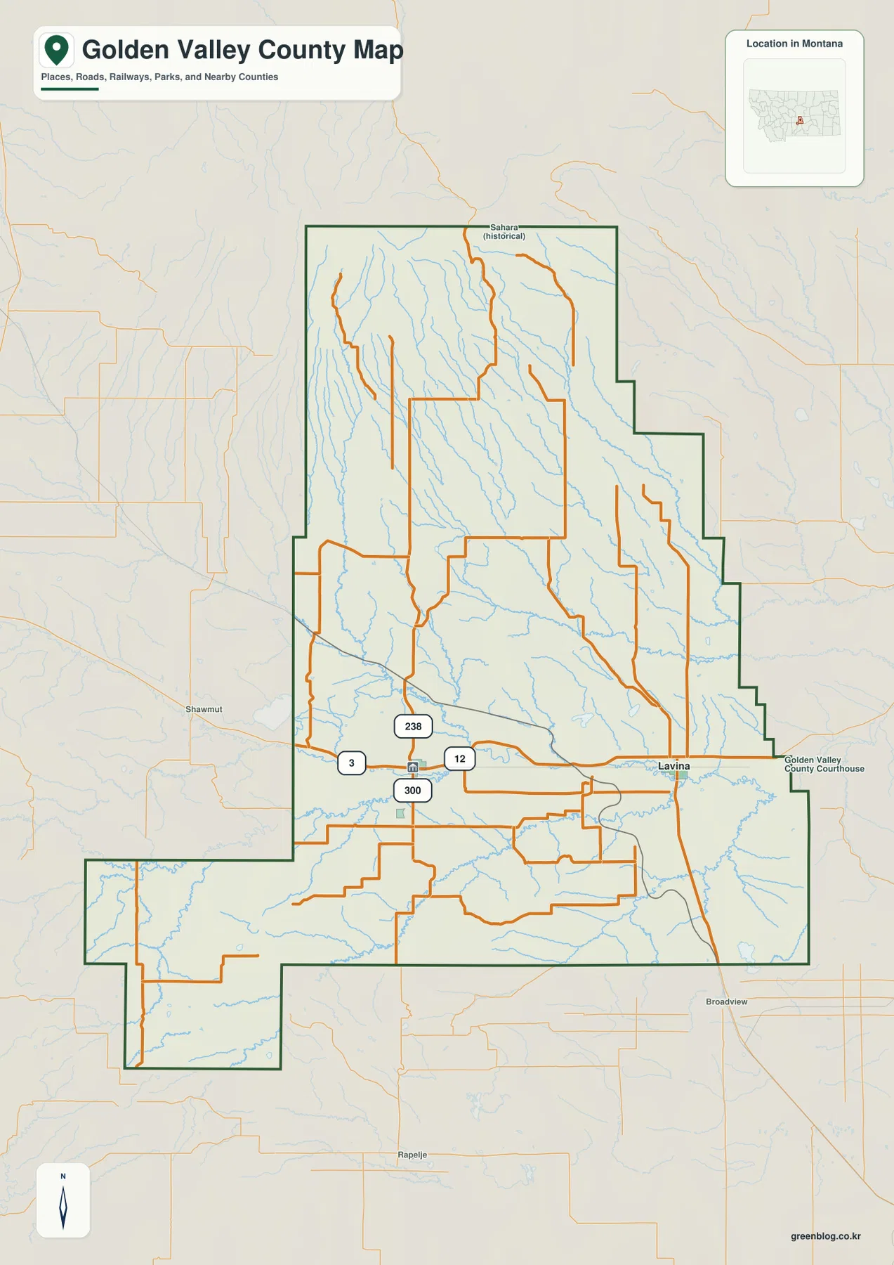
Golden Valley County sits in south-central Montana, where Ryegate and Lavina occupy the Musselshell River valley and broad rural uplands rise around them. The road map is relatively sparse, so rivers and creeks become especially useful once the view moves away from U.S. 12. Musselshell River crosses the lower middle of the county, while Careless, Curry, Cameron, and other creeks descend from the north. The elevation map adds a dramatic contrast, with most of the county relatively low and the northwestern corner rising sharply into high terrain. High-resolution JPG versions of the maps are available together in the download ZIP below.
Golden Valley County’s official site identifies Ryegate as the county seat, which matches its central role on the maps. Ryegate and Lavina both sit close to the Musselshell River corridor, while the large northern interior contains far fewer settlement labels. Starting with those two towns and the river makes the rest of the county easier to understand.
Table of Contents
Ryegate and Lavina anchor the Musselshell River corridor
On the general county map, Ryegate lies in the west-central part of the lower county and Lavina sits farther east. U.S. 12 runs through the same corridor, making it the clearest east-west road reference. Route 3 leaves the Ryegate area toward the southwest, and routes 238 and 300 are also labeled nearby.
North of the river corridor, rural roads spread across a much larger area with few settlement names. East and south of Lavina, local roads continue through open country, while the county boundary steps inward several times along the eastern side. A narrow southwestern projection gives the county an additional irregular shape.
Nearby labels such as Shawmut, Broadview, and Rapelje appear outside the county and help with regional orientation. The map is static, however, so construction, winter closures, and unpaved-road conditions should be checked through current transportation sources before travel.
The city map reduces the county to Ryegate and Lavina
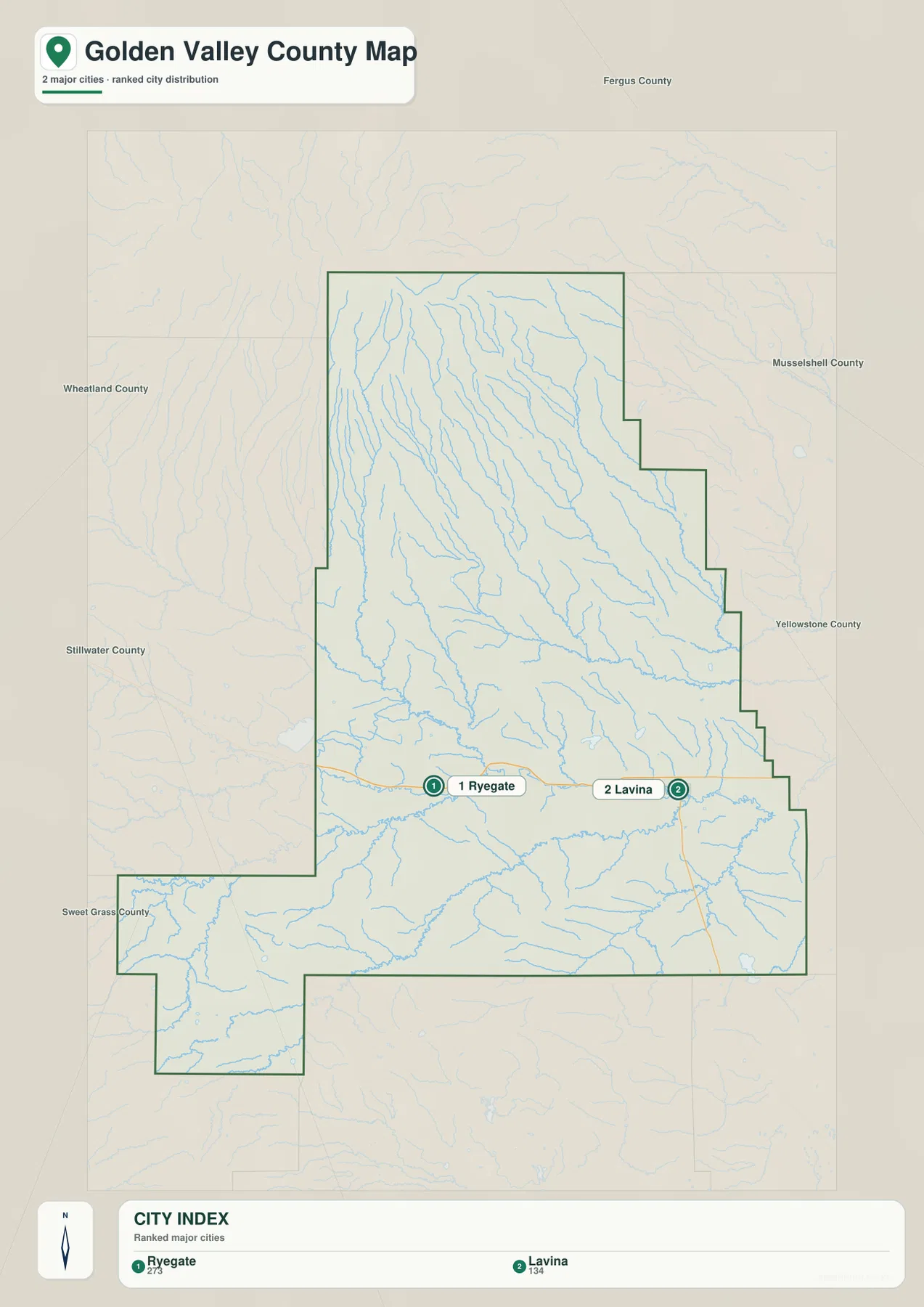
The city map ranks two places: Ryegate and Lavina. Its printed index lists Ryegate at 273 and Lavina at 134. Those figures are the values embedded in the supplied map and should not be treated as guaranteed current population estimates. Current demographic totals should be checked through recent U.S. Census Bureau data.
Ryegate lies in the west-central section and Lavina farther east, with both communities close to the Musselshell River valley. Surrounding county labels include Wheatland, Fergus, Musselshell, Yellowstone, Stillwater, and Sweet Grass counties, which makes the regional location easier to understand.
There is no connector line or mileage label between Ryegate and Lavina on the city map. The spacing should therefore be read only as a location reference, not as road mileage or straight-line distance. Actual travel should be checked on the general map and with current navigation information.
Musselshell River is the strongest water reference across the lower county
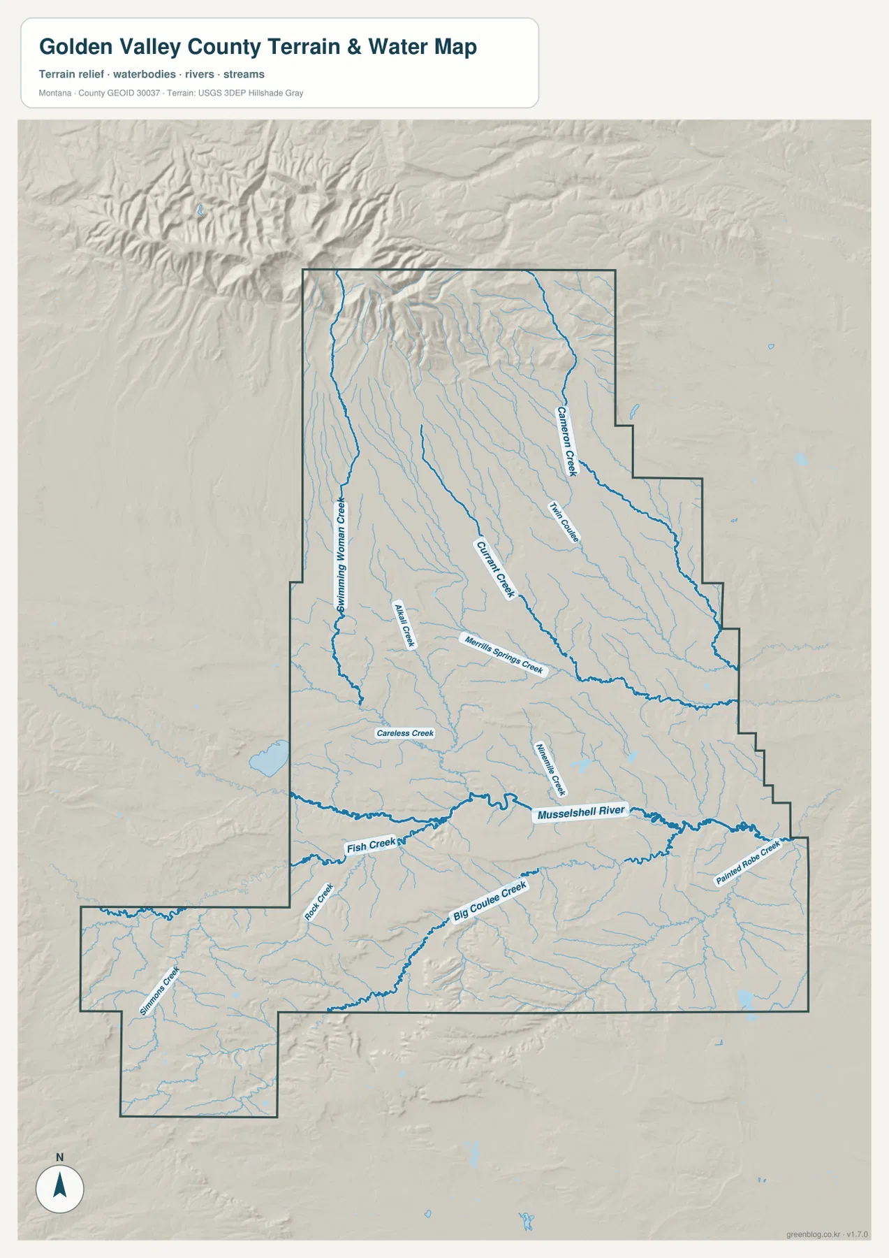
The terrain-and-water map makes Musselshell River the dominant feature across the lower middle of Golden Valley County. The river enters from the west, passes the Ryegate-Lavina corridor, and continues east. Montana Department of Transportation material for the Lavina and Ryegate area also identifies this corridor with the Musselshell River Basin.
North of the river, Careless Creek and Merrill Springs Creek descend through the central interior. Curry Creek and Cameron Creek provide longer references farther north and east, while Swimming Woman Creek and Allen Creek mark the northwestern side. These tributaries show how strongly the northern uplands are cut by valleys even where the road map looks relatively empty.
South of the Musselshell, Fish Creek and Rock Creek approach from the west, Big Coulee Creek crosses the south-central area, and Paint Rock Creek appears in the southeast. This map is intended for geographic reference and should not be used for flood zoning, navigation, parcel boundaries, water-rights decisions, or safe-crossing determinations.
Northern creeks descend from higher country toward the river valley
The northern half contains a clear set of long tributary valleys. Swimming Woman Creek and Allen Creek come out of the higher northwest, while Curry Creek and Cameron Creek divide the broader northern interior. Their roughly southward and southeastward courses point toward the lower Musselshell River country.
Careless Creek is especially prominent in the north-central section, with Merrill Springs Creek farther east. The land between these channels is not a flat plain; ridges and rolling uplands separate the valleys. Comparing the terrain-and-water view with the elevation map makes this relationship much easier to see.
Simmons Creek appears in the county’s narrow southwestern projection and provides a useful marker for that otherwise isolated-looking section. The shape of the boundary is easier to understand once this creek valley is added to the road map.
Elevation ranges from about 1,021 to 2,625 meters
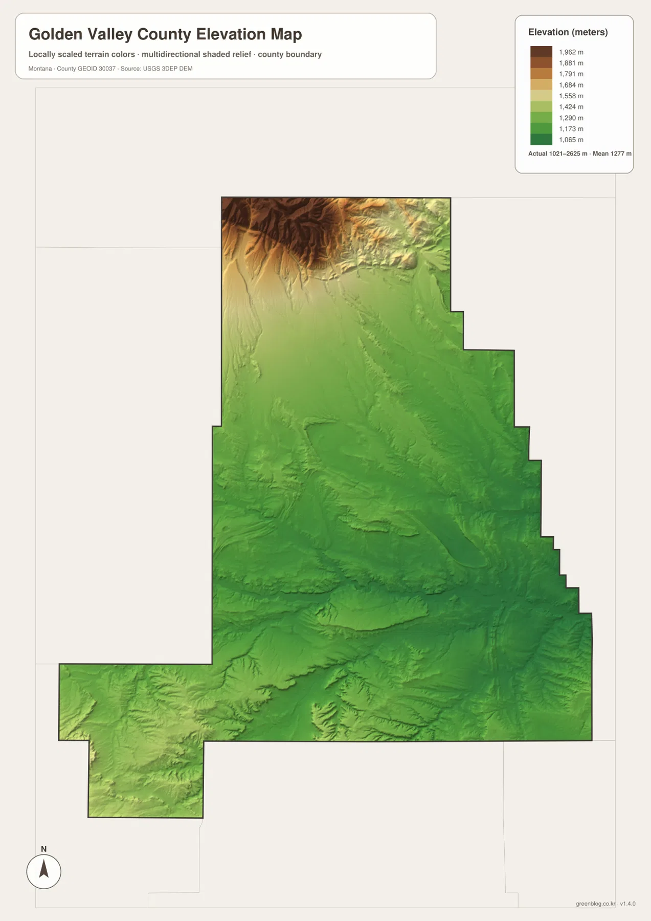
The elevation map reports an actual county range of about 1,021 to 2,625 meters, with a mean elevation near 1,277 meters. Most of the central and eastern county appears in green, including the Musselshell River corridor. The northwestern corner is very different, rising quickly through yellow and brown into the highest terrain on the map.
The high northwest contains tightly packed ridges and valleys. Swimming Woman Creek and other short tributaries descend from this elevated area toward the lower interior. Moving east across the northern county, elevation drops rapidly and the landscape opens into broad rolling country.
The southwestern projection and southern edge contain hills of their own, but they do not reach the same elevation as the northwest. Big Coulee Creek and Rock Creek occupy lower valleys between these uplands. The elevation map is intended for county-wide comparison only and should not be used as survey-grade or engineering-grade data for a specific property.
Ryegate and the Musselshell River make the county easier to organize
A practical way to use the map set is to begin at Ryegate and Lavina along the Musselshell River. U.S. 12 connects the two communities, while Route 3 and routes 238 and 300 provide additional references around Ryegate. Once that lower corridor is familiar, the northern creeks can be followed back into the higher country.
Careless, Curry, and Cameron creeks are useful for dividing the north, while Fish Creek and Big Coulee Creek help with the south. The high northwestern block is easy to identify on the elevation map and explains why so many tributaries descend toward the central river valley. This combination of town, river, and relief provides a clearer mental map than trying to memorize every small rural road.
The WebP images embedded in the article are convenient for quick browsing. The high-resolution JPG files in the ZIP are better for printing or enlarging small road and creek labels. Because these are static reference maps, current road conditions, stream levels, and land-access restrictions should be checked through current official sources.
Frequently Asked Questions
Does the city map show the distance between Ryegate and Lavina?
No. The city map ranks and locates Ryegate and Lavina but does not print a connector distance or road mileage between them. Use the general county map and current navigation information for an actual trip.
Where is the highest terrain in Golden Valley County?
The elevation map shows the strongest concentration of high terrain in the northwestern corner. The central and eastern portions, including the Musselshell River corridor, are generally much lower.
Can the 1,021–2,625 meter elevation range be used for a property or engineering project?
No. The range is a county-wide reference for comparing the lower river valley with the high northwestern terrain. Precise site elevations should come from an authoritative source such as the USGS 3D Elevation Program and, when necessary, a professional survey.
Map File Information
Download the Golden Valley County county, city, terrain-and-water, and elevation maps as high-resolution A3 JPG files.
- Included Files: county map, city map, terrain and water map, elevation map
- File Type: ZIP containing 4 JPG files
Related Maps
Sources and References
County government information is available from the official Golden Valley County website, and the county’s Ryegate page identifies Ryegate as the county seat. Montana Department of Transportation also provides a Lavina/Ryegate Musselshell River Basin reference.
Boundary and road-reference data can be checked through U.S. Census Bureau TIGER/Line Shapefiles. Hydrographic data are available from USGS National Hydrography, and elevation data through the USGS 3D Elevation Program.
Green Map creates custom-edited map images using open geographic data sources such as geoBoundaries, Natural Earth, OpenStreetMap, and government open data. These maps are edited visual materials, not raw data files, and are provided for education, documents, presentations, and graphic reference.