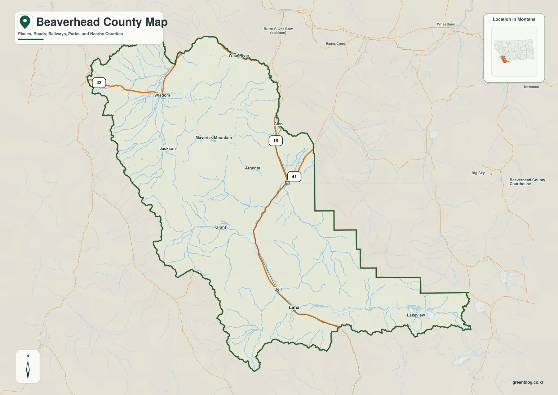
Beaverhead County occupies a broad part of southwestern Montana where high mountain country surrounds long river valleys and widely separated communities. Dillon is the main city shown near the east-central part of the county, while Interstate 15 runs south through the Dillon area toward Dell and Lima. The maps on this page let you compare county boundaries, roads, settlements, rivers, reservoirs, and elevation. High-resolution JPG versions of the map files are available together in the download box later in the article.
The county outline immediately shows why a single town-centered view is not enough here. Beaverhead County spreads far to the west and south, with an irregular stepped boundary on the east and a long southeastern extension. Wisdom and Jackson lie far from Dillon, while Grant, Glen, Dell, Lima, and Lakeview occupy different valleys and road corridors. Looking at the county in sections—Big Hole country in the northwest, the Dillon-Beaverhead valley in the middle, and the Red Rock area in the south and southeast—makes the geography much easier to follow.
Table of Contents
Dillon and the I-15 corridor through the county
Dillon is the clearest reference point for understanding the county’s central road network. Montana Historical Society county facts identify Dillon as the Beaverhead County seat, and the county’s own overview describes Dillon and Lima as its two incorporated municipalities. On the map, Dillon sits in a broad valley near the eastern side of the county. I-15 approaches from the north near Glen, passes the Dillon area, continues toward Clark Canyon Reservoir, and then runs south through the Dell and Lima corridor.
Montana Highway 41 branches east from the Dillon area, giving the central valley another recognizable route. The northwest works differently. Wisdom lies on Highway 43 and is separated from Dillon by a large area of mountains, valleys, streams, and smaller roads. Jackson, Grant, and Argenta are also spread through interior valleys rather than clustered around one urban center. That layout is important when using the map: a place that appears within the same county may still be separated from Dillon by substantial mountain terrain.
The official Beaverhead County overview describes the county as being in Montana’s southwestern corner, with an average elevation above one mile. It also calls Beaverhead the largest county in Montana by land area. Those facts fit what the map shows: communities are far apart, major highways cover only some portions of the county, and large mountain or public-land areas lie between settlements. A county-wide map is therefore more useful than a city-only map when you need basic orientation.
A simplified city view of Dillon and Lima
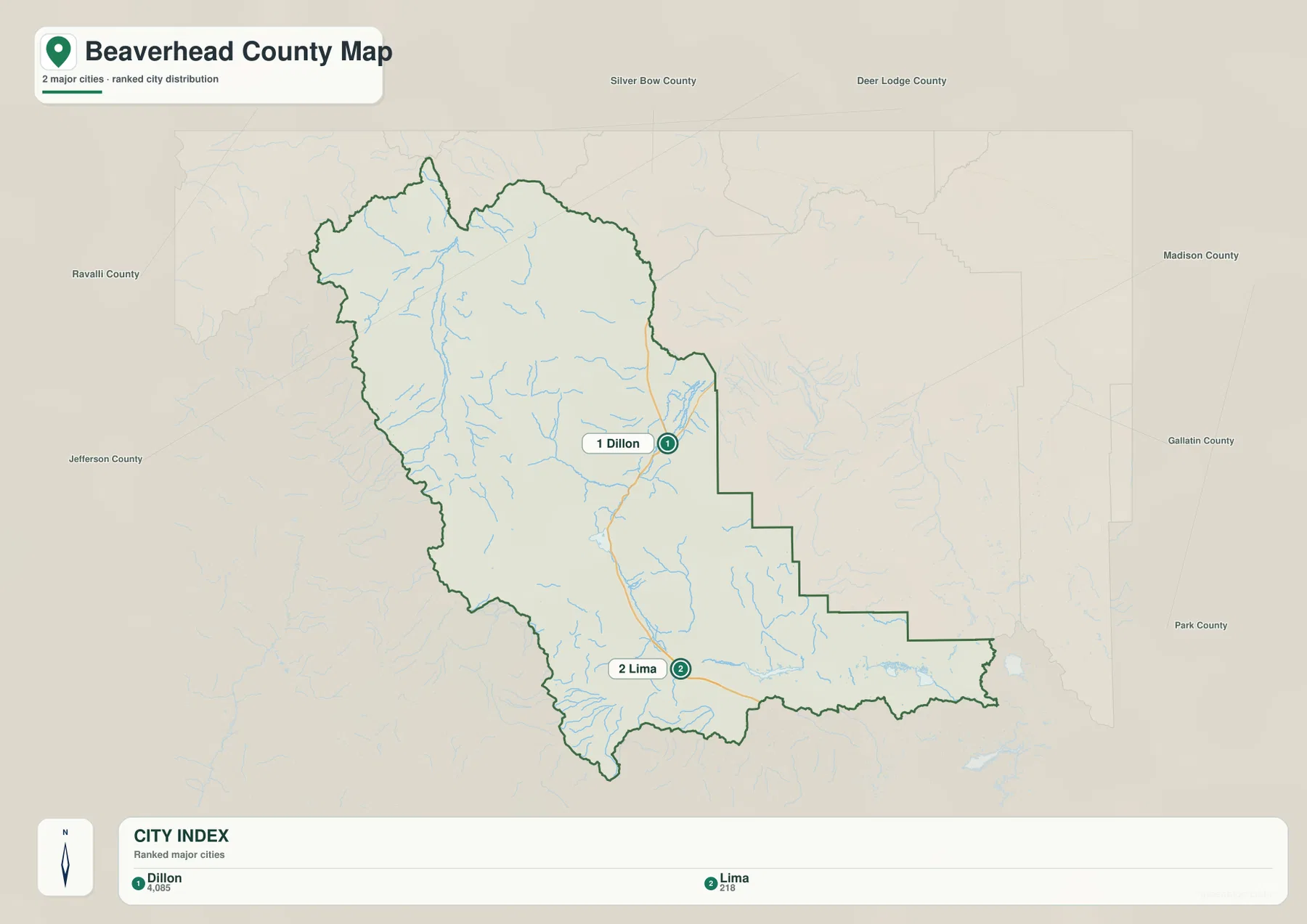
The city map removes many smaller place labels and highlights Dillon and Lima as the two ranked cities. Its index lists Dillon at 4,085 and Lima at 218. Those figures should be treated as the values used in this map rather than as a substitute for a current population estimate, because population counts can change over time. What remains most useful is the location pattern: Dillon is east of center, while Lima lies much farther south along the I-15 corridor.
Following the route south from Dillon helps connect the city map with the broader county map. Clark Canyon Reservoir appears south of Dillon, Dell lies farther down the valley, and Lima is positioned near the southern part of the county. East of Lima, the county stretches into Red Rock River country, where Lima Reservoir and the Red Rock Lakes become stronger geographic reference points than city names. This is why the city map works best as a quick orientation layer rather than a complete settlement map.
No road-distance or straight-line-distance labels are shown between Dillon and Lima on this version of the city map. It should not be used to estimate travel time or exact mileage. Instead, use it to see where the two principal municipalities sit within the county, then switch to current navigation or transportation sources for a driving route. The full county map remains the better choice when you also need Wisdom, Jackson, Grant, Dell, Lakeview, or other labeled places.
Big Hole waters in the north and northwest
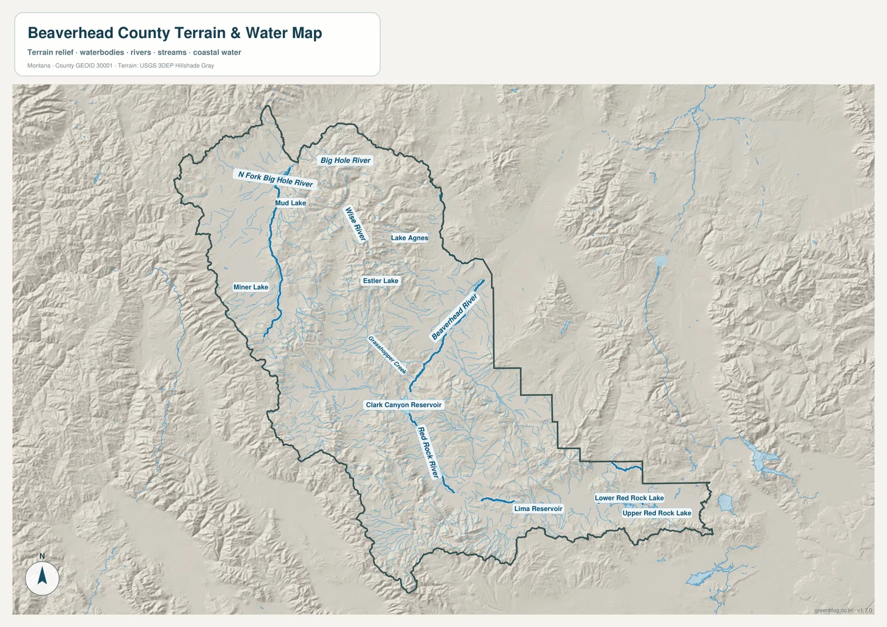
The terrain-and-water map gives the northwest a very different appearance from the Dillon corridor. The North Fork Big Hole River is labeled in the northwest, with the Big Hole River continuing across the northern part of the county. Wise River is also labeled farther north and east. Numerous smaller streams descend from surrounding mountain slopes into the broader valley floors, so the drainage lines make the basin-and-range character of this part of Beaverhead County especially easy to recognize.
Farther toward the center, Grasshopper Creek is a strong named feature leading east toward the Beaverhead River system. The Beaverhead River occupies the east-central valley, while Clark Canyon Reservoir is prominently marked to the south. Because I-15 also passes this general area, the reservoir is a useful landmark for comparing the transportation map with the water map. It separates the Dillon valley to the north from the Red Rock River corridor that continues southward.
Several smaller lakes are labeled in the mountain country, including Miner Lake, Mud Lake, Lake Agnes, and Estler Lake. Their presence helps show how varied the waterscape is, but this map is still a regional reference map. It is not designed to provide boating depths, fishing rules, property ownership, flood zones, or legal access. Anyone planning recreation or site-specific work should confirm those details with the responsible agency and the most current official information.
Red Rock River, Lima Reservoir, and the southeastern lakes
South of Clark Canyon Reservoir, the major named waterway becomes the Red Rock River. It follows the broad southern valley toward the Lima area and continues into the county’s southeastern extension. Lima Reservoir is one of the largest labeled water bodies along this part of the map. Farther east, Lower Red Rock Lake and Upper Red Rock Lake are shown close together near the long southern edge of the county.
Lakeview appears on the general county map in the same southeastern area, giving readers a settlement label to pair with the water features. Comparing the two maps is helpful because the county map emphasizes roads and places, while the terrain-and-water map makes the river and lake system much more visible. The southeastern extension can otherwise seem like an empty piece of the county outline, but the water map shows that it contains a distinct set of valleys, streams, and lakes.
The three major river names on the map also provide a simple way to divide the county mentally. Big Hole River features dominate the north and northwest, the Beaverhead River is central to the Dillon valley, and the Red Rock River provides a strong reference in the south. These are not legal or administrative divisions, but they are practical geographic cues when reading such a large county. They help you move from place names to terrain without relying on a dense road network.
Elevation from about 1,471 to 3,333 meters
The elevation map reports an actual county range of roughly 1,471 to 3,333 meters, with a mean elevation near 2,153 meters. Green shades represent lower valleys, while yellow, tan, and brown mark higher mountain terrain. The contrast is strong across most of Beaverhead County. Broad low areas are enclosed by narrow, steep-looking ridges and higher ranges, which makes the county’s mountainous setting visible even without road or river labels.
The Wisdom area in the northwest occupies a large lower basin, with higher terrain rising along both sides. The Dillon and Beaverhead River valley also forms a lower band in the east-central portion of the county, while long mountain belts rise immediately to the west. Farther south, the I-15 and Red Rock River corridor again occupies relatively lower ground between higher ridges. Comparing this map with the road map shows why major routes tend to follow valleys instead of crossing every high ridge directly.
In the southeast, the country around Lima Reservoir and the Red Rock Lakes is generally lower in color than the county’s highest central and western mountains, although higher ground returns along the southern edge and nearby ridges. Beaverhead County’s official overview notes that much of the county boundary is formed by the Continental Divide. The extended high country visible along the west and south helps place that statement in a geographic context without requiring the elevation map to label individual peaks.
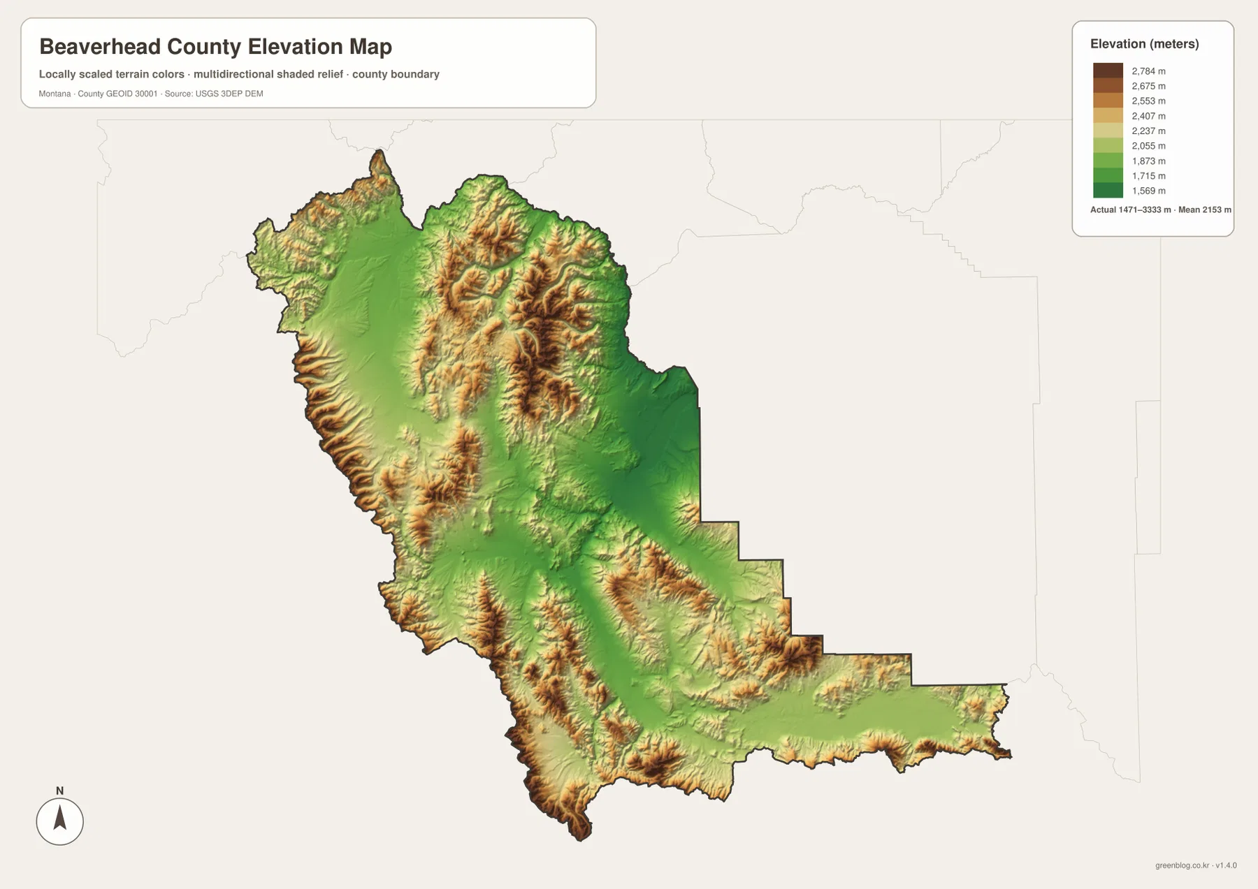
This elevation surface is intended for county-scale comparison, not engineering or survey work. A colored cell or shaded ridge should not be treated as an exact parcel elevation, construction grade, or slope measurement. For precise site elevations, use authoritative elevation data such as the USGS 3D Elevation Program and appropriate local surveying resources. On this page, the elevation map is best used to compare valleys, ridges, and mountain zones across the county.
Choosing the most useful map for the task
Start with the general county map when you need names, roads, and an overall frame of reference. It is the easiest place to locate Dillon, Lima, Wisdom, Jackson, Grant, Glen, Dell, and Lakeview, as well as I-15, Highway 41, and Highway 43. The city map is better when your only question is where Dillon and Lima sit in relation to the county as a whole. These two views reduce the chance of confusing a smaller community with one of the main municipalities.
For rivers, reservoirs, and mountain valleys, the terrain-and-water map should come next. It labels the Big Hole, Beaverhead, and Red Rock river systems and places Clark Canyon Reservoir, Lima Reservoir, and the Red Rock Lakes within shaded relief. Pairing that map with the elevation view is especially useful around Wisdom, Dillon, and the southern I-15 corridor because you can see both the named drainage and the surrounding high terrain.
If you want to print the maps or inspect small labels at a larger size, the downloadable JPG files are more suitable than the WebP previews embedded in the article. The previews are optimized for convenient viewing on the page, while the original JPG files retain a larger image size. For current road closures, construction, legal boundaries, emergency conditions, or property decisions, always use the latest information from the agency responsible for that subject rather than relying on a static county reference map.
Frequently Asked Questions
Which map is best for comparing Dillon and Lima?
Use the city map for the quickest comparison. Dillon is shown in the east-central part of the county and Lima is much farther south, with I-15 linking the same general corridor. If you also need smaller communities such as Wisdom, Jackson, Grant, Dell, or Lakeview, switch to the full county map because it contains more place labels and road context.
Are the Big Hole River and Red Rock River in the same part of Beaverhead County?
They are prominent in different parts of the county. The Big Hole River system is shown mainly in the north and northwest, while the Red Rock River runs through the southern part of the county near Lima. The Beaverhead River and Clark Canyon Reservoir provide the central connection, so the water map is useful for comparing all three geographic areas.
Can the 1,471–3,333 meter elevation range be used for surveying or construction?
No. The elevation map is designed to compare terrain across the county, not to replace a survey or engineering-grade elevation source. The displayed range and color differences are useful for distinguishing valleys from higher mountain country. For exact point elevations or project design, consult USGS elevation data and appropriate professional or local sources.
Map File Information
The Beaverhead County county, city, terrain-and-water, and elevation maps are provided together as original high-resolution JPG files.
- Included Files: county map, city map, terrain and water map, elevation map
- File Type: ZIP containing 4 JPG files
Related Maps
Sources and references
County background, land area, and average elevation are available from the official Beaverhead County website. The Beaverhead County Growth Policy identifies Dillon and Lima as the county’s two incorporated municipalities, while historical county facts, including Dillon as the county seat, are available from the Montana Historical Society.
Boundary and road-reference data can be checked through U.S. Census Bureau TIGER/Line Shapefiles. Water features can be referenced with USGS National Hydrography, and elevation data with the USGS 3D Elevation Program.
Green Map creates custom-edited map images using open geographic data sources such as geoBoundaries, Natural Earth, OpenStreetMap, and government open data. These maps are edited visual materials, not raw data files, and are provided for education, documents, presentations, and graphic reference.