New Madrid County occupies one of the flattest parts of Missouri’s Bootheel, stretching from the Little River drainage and broad western fields to the enormous bends of the Mississippi River on the east. New Madrid sits close to the river near the middle of the county, Portageville anchors the south, Morehouse occupies the narrow northern extension, and Parma and Gideon help define the western lowlands. The county outline changes dramatically from straight interior boundaries to sweeping river curves. High-resolution map files are available for download in the section below.
The maps on this page separate roads and boundaries, major settlements, waterways, and elevation so those contrasts are easier to compare. High-resolution JPG originals of the county map, city map, terrain-and-water map, and elevation map can be downloaded together in one ZIP for closer viewing, A3 printing, classroom use, reports, or other large-format reference work.
Table of Contents
U.S. 61 links the river towns while Route 62 crosses the western plain
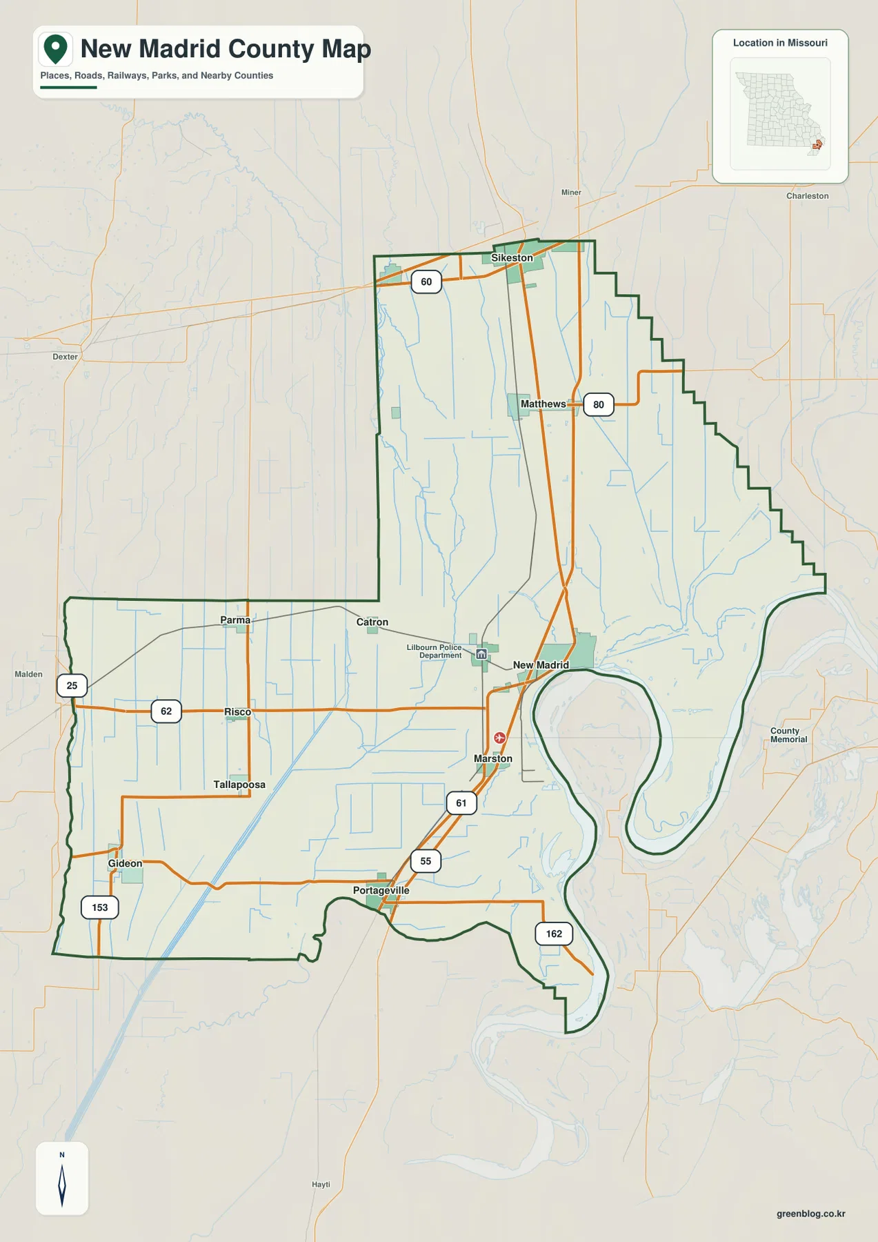
U.S. 61 is the clearest north-south road reference on the general map. It enters the county from the Sikeston side, passes the Matthews area, and continues toward New Madrid, Marston, and Portageville. Near New Madrid, the highway approaches the Mississippi River and follows the more complicated geometry of the river side of the county before continuing south.
The western half has a different road pattern. Route 62 crosses the plain through Risco and continues east toward New Madrid, while Route 25 runs near Parma and Gideon along the western side. Route 80 provides an east-west connection near Matthews, and Routes 153 and 162 appear farther south. These roads make the broad farm country look much more rectilinear than the river-influenced road network in the east.
The county boundary itself is one of the most useful features on the map. A narrow northern section reaches toward Stoddard County, the southwest broadens into a large block around Parma, Risco, and Gideon, and the eastern edge wraps around immense Mississippi River bends. Because the river boundary curves so deeply, locations that appear close in a straight line can require much longer road travel.
Six highlighted communities show how long and wide the county is
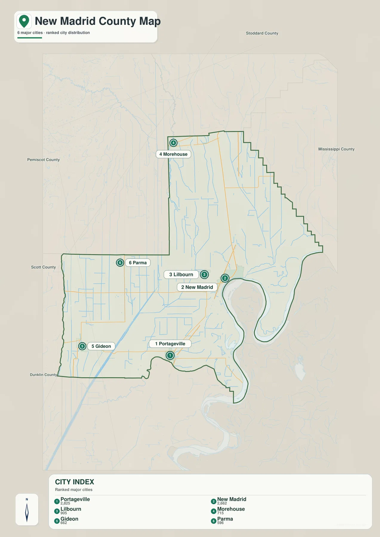
The city map highlights Portageville, New Madrid, Lilbourn, Morehouse, Gideon, and Parma. Portageville and New Madrid are the two highest-ranked places in the city index, but their positions are more important than the ranking itself. Portageville lies in the south, New Madrid is near the Mississippi River in the east-central area, and Lilbourn sits farther west across the lowland interior.
Morehouse is separated from the other highlighted communities in the narrow northern extension. Its position makes the unusual shape of New Madrid County easy to understand because it shows just how far the county reaches beyond the New Madrid and Portageville area. Gideon and Parma occupy the southwest and western plain, giving the map strong reference points away from the Mississippi River.
Once these six places are familiar, the general map becomes much easier to read. Morehouse defines the north, Parma and Gideon frame the west, Portageville marks the south, and New Madrid provides the main river-side reference. This simplified view intentionally leaves out many minor roads and drainage features so the settlement pattern remains clear before moving to the more detailed water and elevation maps.
Little River, drainage ditches, and the Mississippi’s giant loops
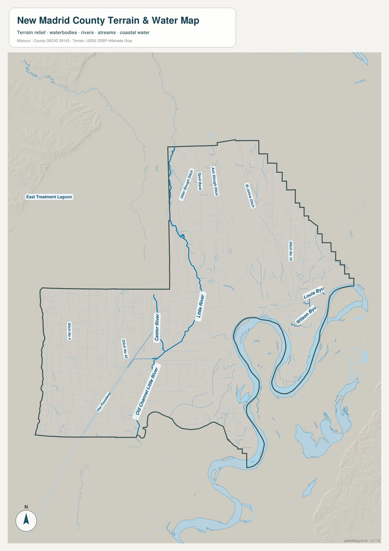
The western and central lowlands are organized around the Little River and a dense network of drainage channels. South of the central county, the map labels the Old Channel Little River and Castor River, along with numbered ditches and smaller features such as The Rodens. Straight or gently curving drainage lines appear repeatedly across the otherwise flat interior, emphasizing how strongly water management has shaped the landscape.
In the narrow northern section, multiple sloughs and ditches run roughly north-south, including St. Johns Ditch and several other labeled channels. They are much smaller than the county’s major rivers, yet they stand out because so many follow parallel or rectangular paths across the plain. Their pattern matches the road grid and reinforces how little natural relief exists across much of western New Madrid County.
The east is dominated by the Mississippi River. Near New Madrid, the river forms an enormous looping bend that shapes the county boundary, with additional bends continuing north and south. Louis Bayou and Wilson Bayou appear near the river side, where broad floodplain surfaces and abandoned channels create a very different landscape from the straight drainage system farther west. The water map is a geographic reference only; it should not be used to determine current flood risk, levee condition, water depth, navigation safety, or legal water boundaries.
A low-relief county ranging from about 78 to 122 meters
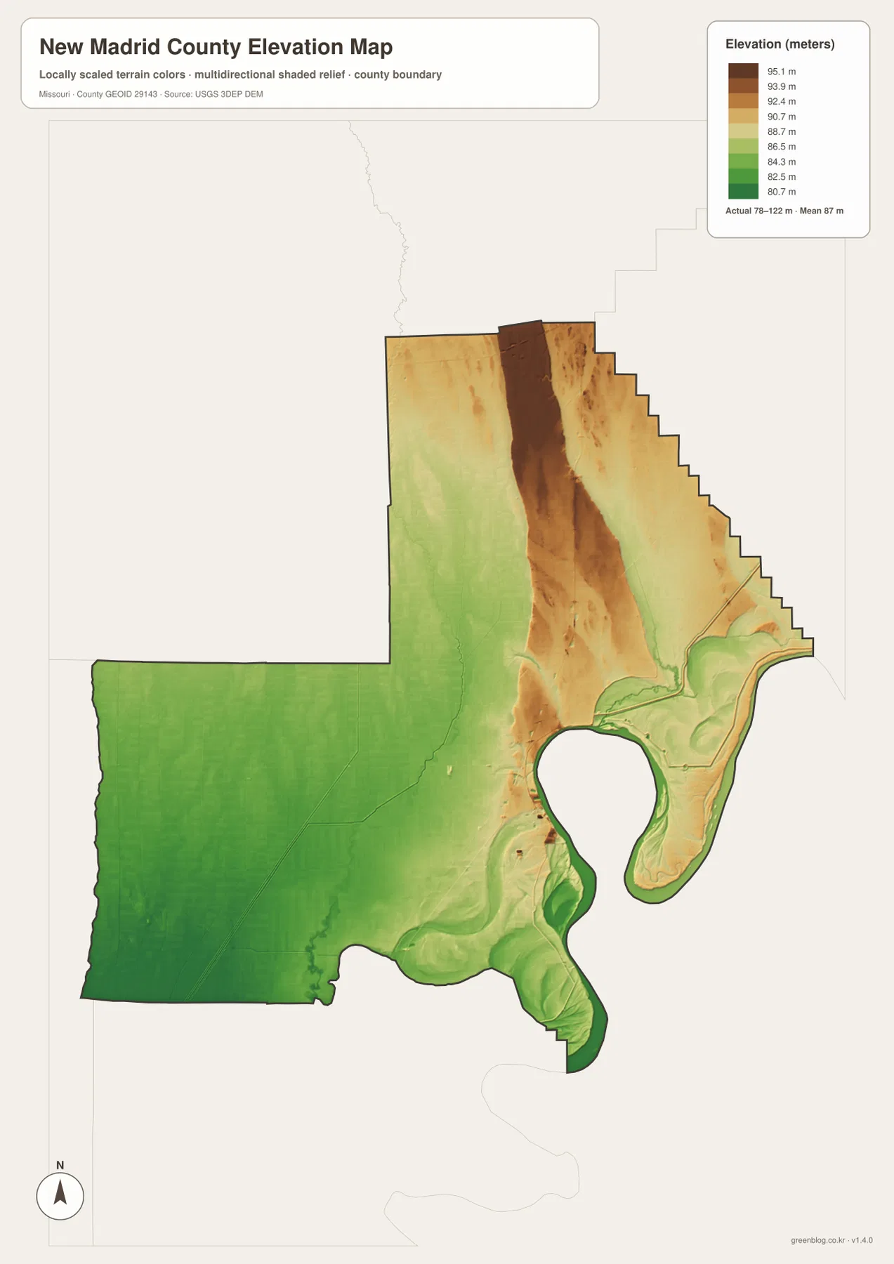
The elevation map reports an actual range of about 78 to 122 meters and a mean near 87 meters. Most of the southwest and much of the Mississippi River floodplain are shown in lower green tones, confirming that large parts of the county are only modestly above the regional lowlands. Compared with the hillier parts of Missouri, the overall relief is small.
Relatively higher ground appears through the long northern section, especially in a brown belt running northward near the center and northeast. This is not mountainous terrain; it is simply higher than the surrounding plain by a few tens of meters. Near New Madrid, the colors drop back toward greens as the land approaches the Mississippi River floodplain and the broad low surfaces around its bends.
The lower southern and western areas also contain curved depressions and old-channel shapes that resemble features on the water map. Comparing the two maps helps explain why drainage ditches are so prominent: when relief is limited, even small differences in height can influence where water collects and how it is moved across the landscape. The elevation layer is suitable for county-scale comparison but not for engineering, drainage design, construction, parcel-level elevation decisions, or survey-grade measurements.
Choose the map by the detail you need
Start with the general county map when roads and place names matter most. U.S. 61 quickly locates New Madrid and Portageville, Route 62 connects the western plain, and the county outline reveals the large Mississippi River bends. The city map is cleaner when you only need the relative positions of the six highlighted communities without the distraction of every drainage channel.
For waterways, the terrain-and-water map contains much more detail. Little River, Castor River, the old Little River channel, the Mississippi River, bayous, sloughs, and numerous ditches can all be compared there. Switching to the elevation map afterward shows why those channels occupy such broad low surfaces and why the northern extension stands slightly higher than the southwest.
The downloadable JPG originals provide more pixels than the WebP previews embedded on the page, making them better for enlargement, A3 printing, classroom handouts, reports, and personal reference. They remain general-purpose maps, however. Legal boundaries, land ownership, live road restrictions, flood status, levee conditions, and precise site elevations should always be checked against the appropriate current official source.
Frequently Asked Questions
What is the easiest road reference between New Madrid and Portageville?
U.S. 61 is the clearest reference. It runs south through the eastern half of the county, passing the New Madrid and Marston area before continuing toward Portageville, so several major settlements can be located from the same highway.
Is New Madrid County mountainous?
No. The elevation map shows an actual range of only about 78 to 122 meters, with a mean near 87 meters. The western plain and Mississippi River floodplain are especially low, while part of the northern extension is modestly higher.
Why are so many ditches shown on the water map?
Much of the county is extremely flat, so drainage channels are a major part of the visible water network. The map shows Little River together with numbered ditches, sloughs, and bayous, but it is only a geographic reference and does not indicate current flood risk or water levels.
Map File Information
The download ZIP contains high-resolution JPG versions of the New Madrid County general map, city map, terrain-and-water map, and elevation map.
- File Type: JPG
Related Maps
Sources and References
Boundary and road reference data are supported by U.S. Census Bureau TIGER/Line, water features by USGS National Hydrography, and elevation data by the USGS 3D Elevation Program. These maps are general geographic references and are not substitutes for legal surveys or current operational data.
Green Map creates custom-edited map images using open geographic data sources such as geoBoundaries, Natural Earth, OpenStreetMap, and government open data. These maps are edited visual materials, not raw data files, and are provided for education, documents, presentations, and graphic reference.