Gentry County lies in northwestern Missouri, where small towns and rural roads sit among the branching valleys of the Grand River system. Albany is the clearest eastern reference, Stanberry anchors the west, and King City marks the southwest. McFall, Gentry, and Darlington complete the ranked community set. The maps on this page connect those places with U.S. 136, U.S. 169, local roads, rivers, creeks, lakes, and an elevation range of roughly 234 to 340 meters. High-resolution JPG versions of the same map themes are available together in a ZIP for printing or offline use. High-resolution map files are available for download in the section below.
The county is easiest to understand by starting with Albany and then following the water network outward. The Grand River, East Fork Grand River, and Middle Fork Grand River create broad lower corridors through the center and east, while Wildcat Creek cuts across the western side. Higher rolling ground fills much of the space between those valleys, especially toward the southwest and northwest.
Table of Contents
Albany and U.S. 136 provide the clearest orientation
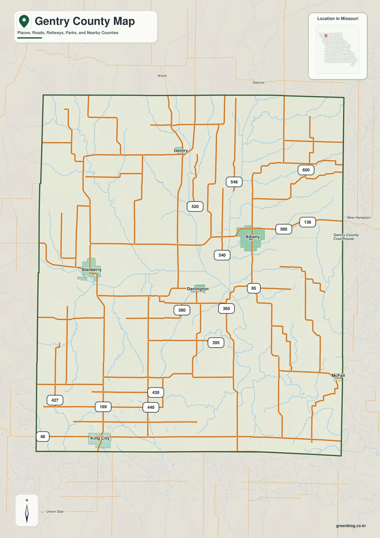
Albany stands out as the county’s main eastern town and the location of Gentry County government offices. U.S. 136 is the strongest east-west road reference near the city, while Route 85 runs south from the Albany area. The general map also labels local roads such as 540, 548, 580, and 600. These roads cross a rural landscape where streams and farmland shape the route pattern more strongly than an urban street grid.
From Albany, the map opens westward toward Darlington and Stanberry and southward toward McFall and King City. Roads bend around drainage valleys and property patterns rather than staying perfectly straight. The map is useful for county-scale orientation, but current turn-by-turn travel and road conditions should still be checked with a live navigation source.
Stanberry and King City define the western and southwestern sides
Stanberry lies near the western side of the county and makes a useful counterpoint to Albany. Darlington sits between the two, while Wildcat Creek and smaller tributaries occupy the broad rural area around them. Stanberry’s road connections make it a practical reference for the west-central portion of Gentry County, especially when the general map is compared with the water layer.
King City is close to the southwestern boundary, where U.S. 169 and Route 48 provide easy orientation. Missouri Department of Conservation lists Limpp Community Lake in Gentry County near King City and gives access from Highway 48 and Route CC. The lake also appears on the supplied water map, making it a useful landmark for the southwestern corner of the county.
Six ranked communities show a widely dispersed settlement pattern
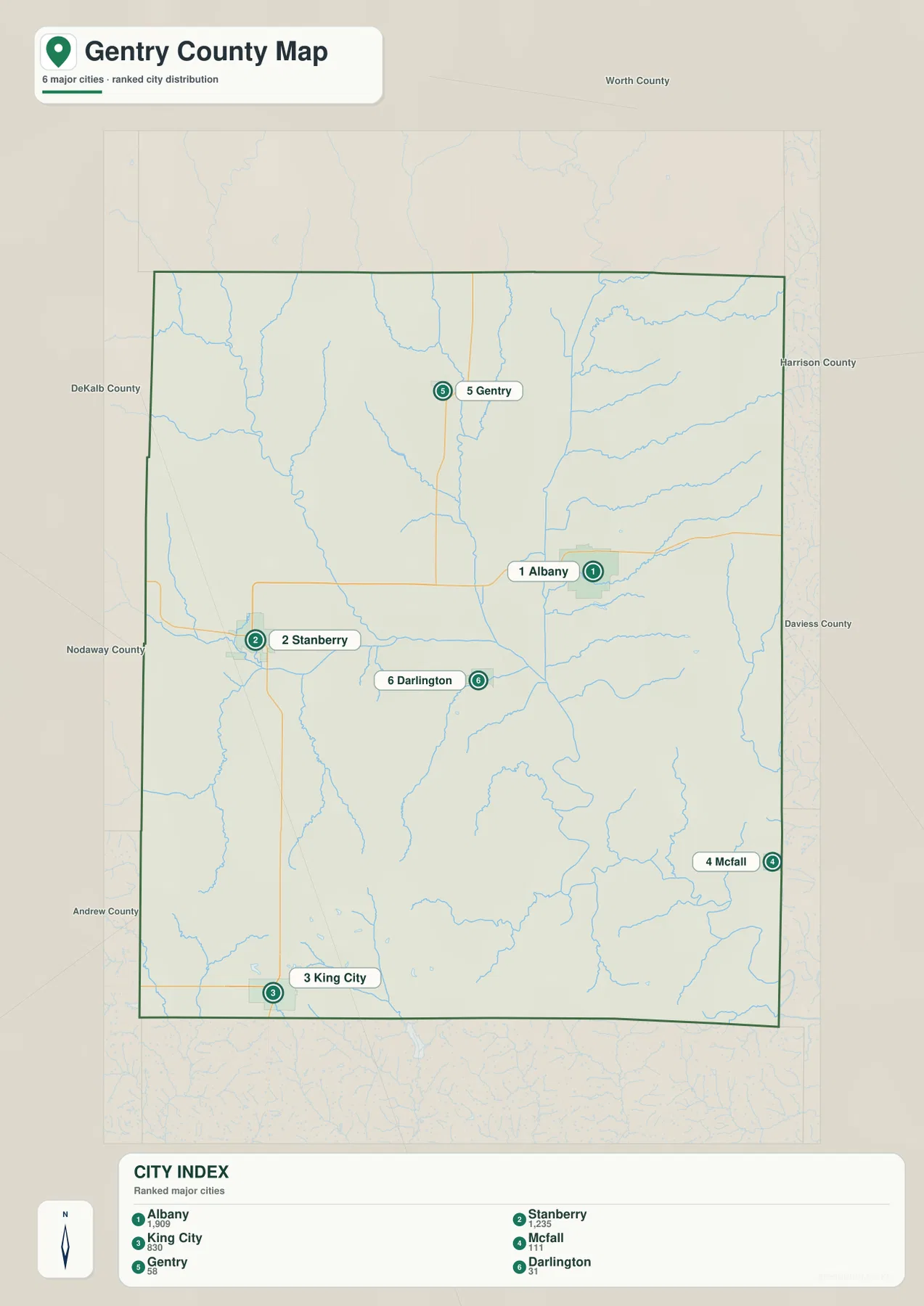
The city distribution map ranks Albany first, Stanberry second, King City third, McFall fourth, Gentry fifth, and Darlington sixth. The CITY INDEX also displays values of 1,909 for Albany, 1,235 for Stanberry, 830 for King City, 111 for McFall, 58 for Gentry, and 31 for Darlington. These are values from the map’s ranking dataset and should not be treated as current official population estimates.
The distribution itself is the more useful feature. Albany sits in the eastern half, Stanberry is west, King City is far southwest, McFall is close to the southeastern boundary, and Gentry occupies the north-central area. Darlington lies between the larger western and eastern communities. The numbered markers are not road mileage or travel-time measurements.
Grand River and East Fork create the largest low valley
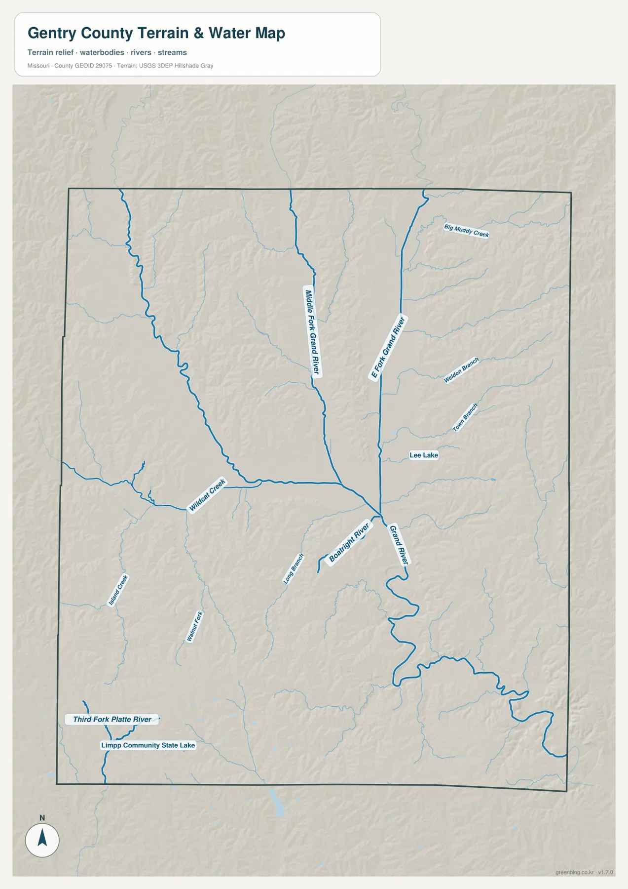
The most prominent drainage corridor on the terrain-and-water map is the Grand River system. Grand River occupies the central-eastern part of the county and continues south, while East Fork Grand River descends from the north and joins the larger valley. Lee Lake is labeled nearby and provides another local reference in the same part of the county. On the elevation map, this river junction aligns with one of the broadest green lowlands.
Big Muddy Creek, Weldon Branch, and Town Branch enter the eastern drainage from surrounding uplands. The branching pattern shows why the area around Albany is not simply a featureless plain. Streams occupy lower ground between narrow ridges, and their valleys become easier to follow when the water and elevation maps are viewed together.
Middle Fork and Wildcat Creek divide the north-central and western uplands
Middle Fork Grand River runs south through the north-central part of Gentry County and eventually connects with the larger Grand River system. Wildcat Creek approaches from the west and crosses a separate set of rolling hills. Together, these waterways divide the broad area between Gentry, Stanberry, Darlington, and Albany into smaller valleys rather than one continuous upland.
Farther southwest, Island Creek and other small tributaries lead toward a different drainage area. Third Fork Platte River and Limpp Community State Lake appear close to the southern boundary. That contrast is useful: much of the center and northeast belongs visually to the Grand River network, while the far southwest includes water features tied to the Platte River side of the landscape.
Limpp Community Lake gives King City a clear natural landmark
Limpp Community Lake is shown near the southwestern edge of the county, not far from King City. Missouri Department of Conservation describes the property as a Gentry County conservation area and provides directions from King City using Highway 48 and Route CC. That official reference makes the lake one of the easiest named natural features to connect with the road map.
The lake sits outside the broad Grand River lowland and closer to the rolling southwestern terrain. Readers can find King City first on the general map, use U.S. 169 and Route 48 for orientation, and then switch to the water map to locate Limpp Community Lake and Third Fork Platte River. The water layer is a geographic reference, not a flood forecast, parcel map, or boating-navigation product.
Elevation ranges from about 234 to 340 meters
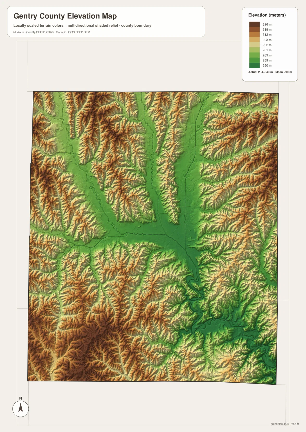
The elevation layer reports an actual mapped range of approximately 234 to 340 meters, with a mean near 290 meters. The Grand River and East Fork Grand River corridors appear in green as lower terrain, and the Middle Fork and Wildcat Creek valleys form additional low strips. Higher ground occupies the spaces between these drainage corridors rather than forming one single ridge.
The southwest and northwest contain some of the strongest brown and tan shading, and higher ridges also appear in the northeast. By contrast, the central-eastern river junction creates a wide low area that is easy to trace. This county-scale elevation map is suitable for comparing relative terrain, but it is not survey-grade or engineering-grade data for construction or parcel decisions.
Albany and Stanberry sit in noticeably different terrain settings
Albany and Stanberry are useful places to compare because they anchor opposite sides of the county. Albany lies close to the larger Grand River drainage, where lower valleys spread across the east-central landscape. Stanberry is surrounded by Wildcat Creek and smaller western tributaries, with more rolling ground nearby. The difference becomes clearer after locating both towns on the road map and then moving to the elevation layer.
Darlington provides a useful intermediate point between them. The water map shows several drainage lines crossing the area, while the elevation map reveals ridges between the stream valleys. This explains why the county does not read as one uniform plain even though there are no major mountain ranges.
County government and public services are centered in Albany
Gentry County’s official elected-officials page lists county offices at the Gentry County Courthouse in Albany, including the county commission and other elected offices. That current public information matches the map’s role for Albany as the county’s main administrative reference.
University of Missouri Extension also maintains its Gentry County office in Albany. The office provides local resources in agriculture, business, health, youth programs, and community education. After using the map to locate Albany, readers who need practical county information can move to those official pages for current contacts and services.
Choosing the right downloadable map file
Use the general county map when roads and communities are the priority. The ranked city map is the quickest way to compare Albany, Stanberry, King City, McFall, Gentry, and Darlington. The terrain-and-water layer is best for the Grand River forks, Wildcat Creek, Big Muddy Creek, Third Fork Platte River, and Limpp Community Lake, while the elevation map highlights the contrast between river bottoms and surrounding uplands.
The ZIP contains high-resolution JPG files for the same map themes shown on the page. They are convenient for enlarging labels, printing a reference sheet, or comparing layers side by side. The files are intended for general geographic reference and do not replace live navigation, emergency warnings, legal boundary surveys, or professional elevation measurements.
Frequently Asked Questions
What is the easiest place to use as a reference in Gentry County?
Albany is the clearest starting point. U.S. 136 passes nearby, the town is close to the main Grand River drainage, and county government offices are located there.
Do the numbers on the city map show distance?
No. They rank Albany, Stanberry, King City, McFall, Gentry, and Darlington within the supplied city dataset. The markers and CITY INDEX values are not road mileage or travel times.
What elevation range does the Gentry County map show?
The elevation layer shows an actual range of about 234 to 340 meters, with a mean near 290 meters. River valleys are lower, while rolling uplands rise between the main drainage corridors.
Map File Information
Download the map files associated with this page for reference, printing, and compatible visual projects.
- Included Files: Use only the versions confirmed in the article and supplied images
- File Type: Use the confirmed download contents
- Intended Use: Printing, education, presentations, and map-based projects
Related Maps
Sources and references
- Gentry County – Elected Officials – county courthouse and government offices in Albany
- University of Missouri Extension – Gentry County – Albany county office and local public programs
- Missouri Department of Conservation – Limpp Community Lake – lake information and directions from King City
- U.S. Census Bureau TIGER/Line Shapefiles – county boundary and road data
- USGS National Hydrography – rivers, streams, and water features
- USGS 3D Elevation Program – elevation data
Green Map creates custom-edited map images using open geographic data sources such as geoBoundaries, Natural Earth, OpenStreetMap, and government open data. These maps are edited visual materials, not raw data files, and are provided for education, documents, presentations, and graphic reference.