You can download three high-resolution A3 JPG maps of McMullen County, Texas, in one ZIP directly from this page. This package contains a general county map, a terrain-and-water map, and an elevation map; there is no city map in this set. The maps show Tilden, Calliham, Loma Alta, roads labeled 97, 72, 99, 308, 889, 16, 624, 59, and 791, the Frio and Nueces river systems, several named creeks and channels, and an actual elevation range of about 45 to 209 meters.
Tilden is the best place to begin because it lies near the center of the county and several road directions can be organized around it. Roads extend west and east through the Tilden area, Route 308 runs south, and Route 99 provides a useful north-south reference farther east. Route 791 is near the northern boundary, while roads 16, 624, and 59 help locate the southern end. Once those road references are familiar, the water map reveals two major low corridors: Frio River across the north and Nueces River through the lower half.
Table of Contents
Tilden provides the clearest road reference in the middle of the county
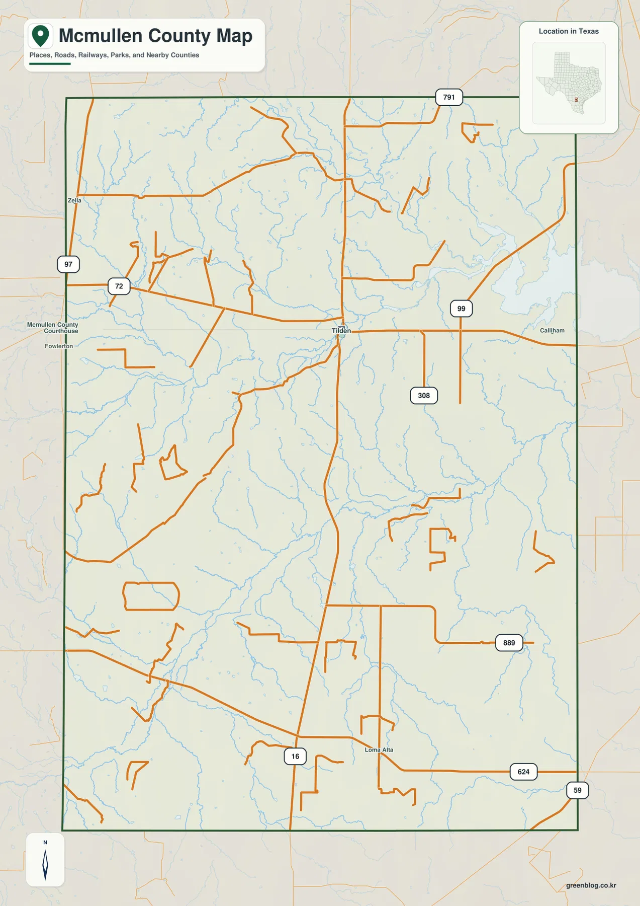
Tilden is the main internal place label on the general map. It sits near the county center, where several roads approach or leave in different directions. An east-west road continues from Tilden toward Calliham, while Route 99 is labeled in the eastern-central part of the county. Route 308 runs south from the Tilden area and is one of the easiest lines to follow when moving from the middle toward the lower county.
Near the northern edge, Route 791 is clearly labeled. Roads 97 and 72 appear on the western and northwestern side and provide additional reference points for the county’s broad upper half. Fowlerton and Zella are visible outside or near the western edge as regional orientation labels, but the article keeps its main discussion focused on places and features inside the mapped county boundary.
Farther south, Loma Alta is labeled close to Route 16. Route 889 runs through the southeastern interior, with Route 624 and Route 59 providing additional references toward the lower-right side. The road map initially looks open and sparsely settled, but the numerous blue stream lines between the roads hint at the complicated drainage pattern that becomes much clearer on the terrain-and-water view.
Frio River forms the main northern drainage corridor
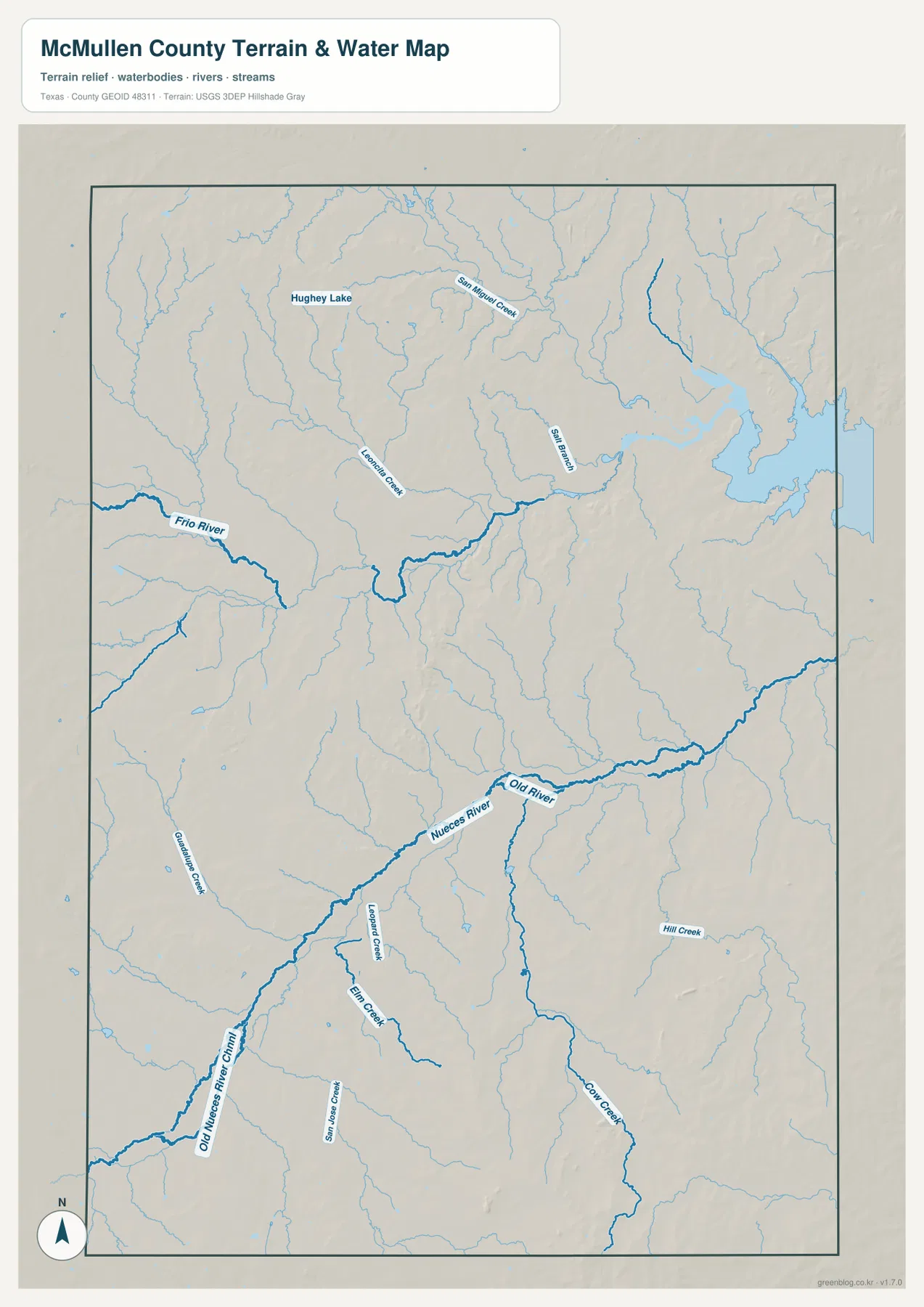
Frio River is the most prominent named water feature in the northern half of the terrain-and-water map. It enters from the west, bends across the north-central interior, and continues toward the east. Numerous smaller tributaries feed the river from higher ground, turning what looks like broad open space on the road map into a network of shallow valleys and drainage lines.
San Miguel Creek is labeled north of the Frio River, while Leonard Creek appears farther west. Hughey Lake is another named reference near the upper part of the map. These features are smaller than the Frio River but useful for understanding that the northern drainage is not controlled by one channel alone.
Toward the eastern side, the Frio corridor becomes increasingly winding and joins a broader concentration of water features near the county edge. The supplied image does not provide clear names for every visible water body or tributary, so this article avoids assigning names to unlabeled features. The emphasis remains on the named rivers, creeks, channels, and lake that can be read directly from the map.
Nueces River and Old River define a separate southern valley system
Nueces River is the strongest named water feature in the lower half of McMullen County. It enters from the southwest and follows a winding course toward the east. Old River is labeled beside part of the same broad lowland, providing a second named channel in the valley. The two names make the southern drainage easy to distinguish from the Frio system farther north.
Old Nueces River Channel is labeled in the southwest, adding another visible watercourse associated with the lower river area. Elm Creek appears nearby, while Hill Creek is labeled farther east. Additional tributaries enter from both sides, creating a long connected valley that cuts across the southern interior.
The contrast between the Frio and Nueces systems is useful for orientation. Tilden lies between these broad northern and southern drainage regions, so comparing the road map with the water map makes the county much easier to understand. The terrain-and-water layer is intended for geographic reference; it is not a flood-hazard map, parcel map, legal water-boundary product, or navigation chart.
High northwest and southeast hills frame the lower Frio and Nueces valleys
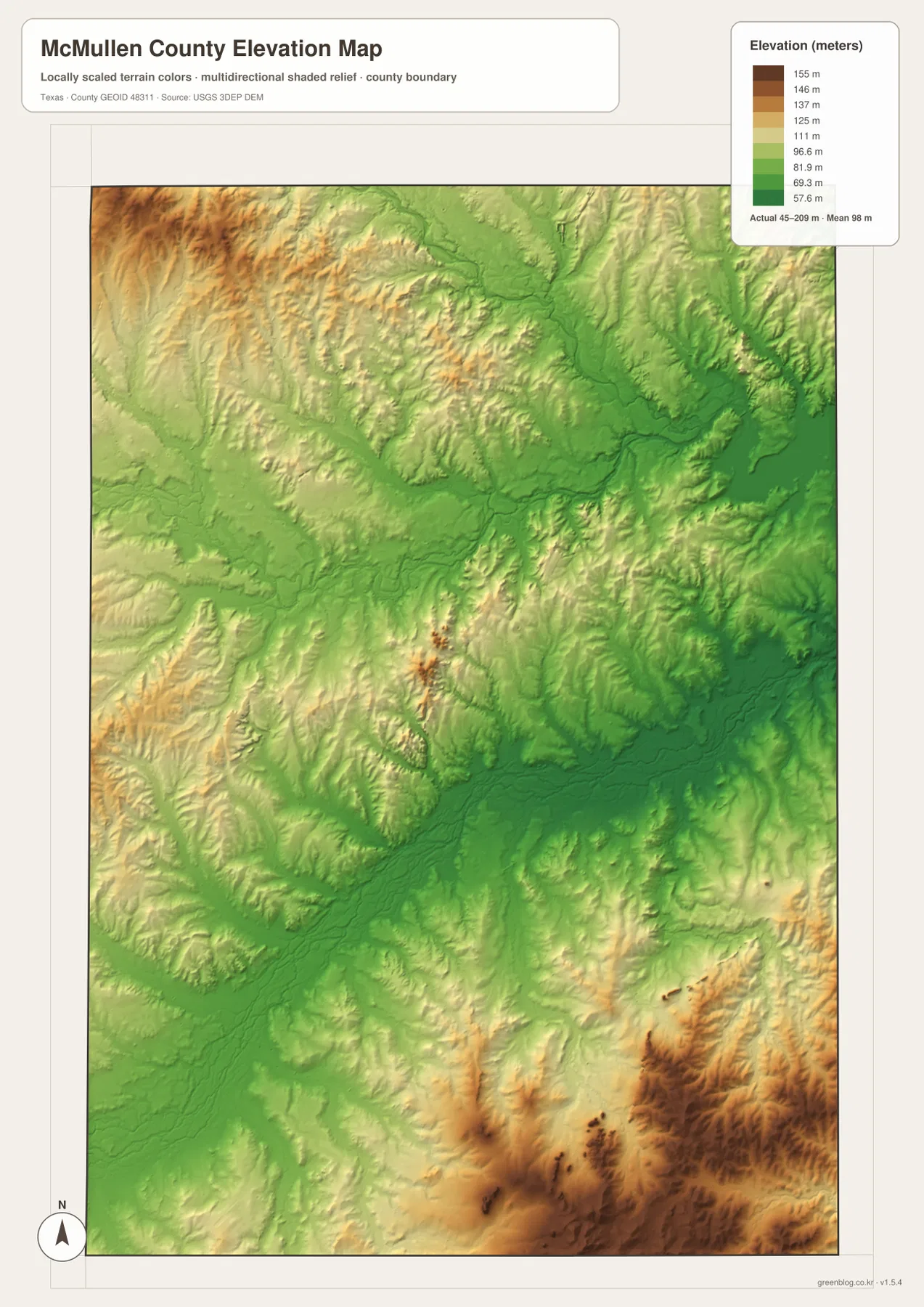
The elevation map reports an actual range of about 45 to 209 meters and a mean elevation of about 98 meters. The highest brown terrain is concentrated in the northwest and especially the southeast. Broad green lowlands extend through the central and eastern portions, with the Frio and Nueces river corridors occupying some of the lowest visible terrain.
The northwestern high ground is strongly dissected by tributary valleys rather than forming a smooth plateau. Narrow green corridors cut through tan and brown hills toward the Frio River. In the north-central area, the main river valley widens into a broad lower zone, matching the drainage pattern on the water map.
The southeastern corner contains some of the county’s most elevated terrain. Dark brown ridges and hills cover a large area, while lower tributary valleys push into them from the north and west. The Nueces River corridor remains much lower by comparison. Some additional high ground appears in the southwest, but the strongest overall contrast is between the high southeast and the low river valleys.
The difference between the displayed minimum and maximum elevation is about 164 meters. McMullen County is not a mountain county, yet the shaded relief shows enough local relief for the ridge-and-valley pattern to be obvious. The elevation layer is best used for relative terrain comparison rather than survey-grade or engineering-grade measurement.
Using Tilden to compare the northern and southern river systems makes the county easier to read
Start at Tilden on the general map and move north toward roads 72, 97, and 791. The road view looks relatively open, but the terrain-and-water map replaces that impression with the Frio River, San Miguel Creek, and numerous tributaries. The elevation map shows the same broad area as a mix of higher hills and lower green valleys.
Moving south from Tilden produces a different sequence. Route 308 leads toward the lower county, Route 16 passes the Loma Alta area, and roads 624 and 59 help define the southeastern side. On the water map, Nueces River, Old River, Old Nueces River Channel, and Elm Creek occupy the same broad lower region. The elevation map then shows a low river corridor immediately beside some of the county’s highest southeastern hills.
Use the general map when road numbers and place labels are the main question, the terrain-and-water map when named rivers and creeks matter, and the elevation map for the contrast between uplands and river valleys. Because this package does not include a city map, those three layers provide the complete set. Smaller labels are often easier to inspect in the downloadable high-resolution JPG files than in the browser previews.
Frequently Asked Questions
Which maps are included in this McMullen County package?
This set contains three maps: a general county map, a terrain-and-water map, and an elevation map. There is no city map in the package. The three layers cover Tilden and roads, the Frio and Nueces river systems, and the county’s 45–209 meter elevation range.
Which rivers are the best water references?
Frio River is the strongest northern reference, while Nueces River defines the main southern corridor. San Miguel Creek, Leonard Creek, Hughey Lake, Old River, Old Nueces River Channel, Elm Creek, and Hill Creek are also labeled on the supplied water map.
What elevation range is shown for McMullen County?
The supplied elevation map reports an actual range of about 45 to 209 meters and a mean of about 98 meters. The northwest and southeast contain much of the higher terrain, while the Frio and Nueces river valleys form lower corridors through the county.
Sources and Reference Data
- U.S. Census Bureau TIGER/Line Shapefiles — official county-boundary and road geometry for geographic reference.
- USGS National Hydrography — official resources for rivers, creeks, lakes, and channels.
- USGS 3D Elevation Program — official elevation resources used for terrain information.
- USGS The National Map Viewer — an official viewer for comparing geographic layers.
Map File Information
Download three high-resolution A3 JPG maps of McMullen County, Texas, in one ZIP file.
- Included Files: county map, terrain and water map, elevation map
- File Type: JPG
Related Maps
- Atascosa County Texas map
- Webb County Texas map
- Zavala County Texas map
- San Patricio County Texas map
- Bandera County Texas map
Green Map creates custom-edited map images using open geographic data sources such as geoBoundaries, Natural Earth, OpenStreetMap, and government open data.
These maps are edited visual materials, not raw data files, and are provided for education, documents, presentations, and graphic reference.