Cooper County occupies a central Missouri landscape where the Missouri River forms the dominant northern edge and a web of smaller valleys cuts through the interior. This page is designed to help readers locate Boonville, Blackwater, Pilot Grove, Bunceton, Otterville, Prairie Home, and other mapped places while comparing roads, settlement patterns, waterways, and elevation. The WebP maps shown on the page are paired with high-resolution JPG versions that can be downloaded together in a single ZIP for printing or offline reference. High-resolution map files are available for download in the section below.
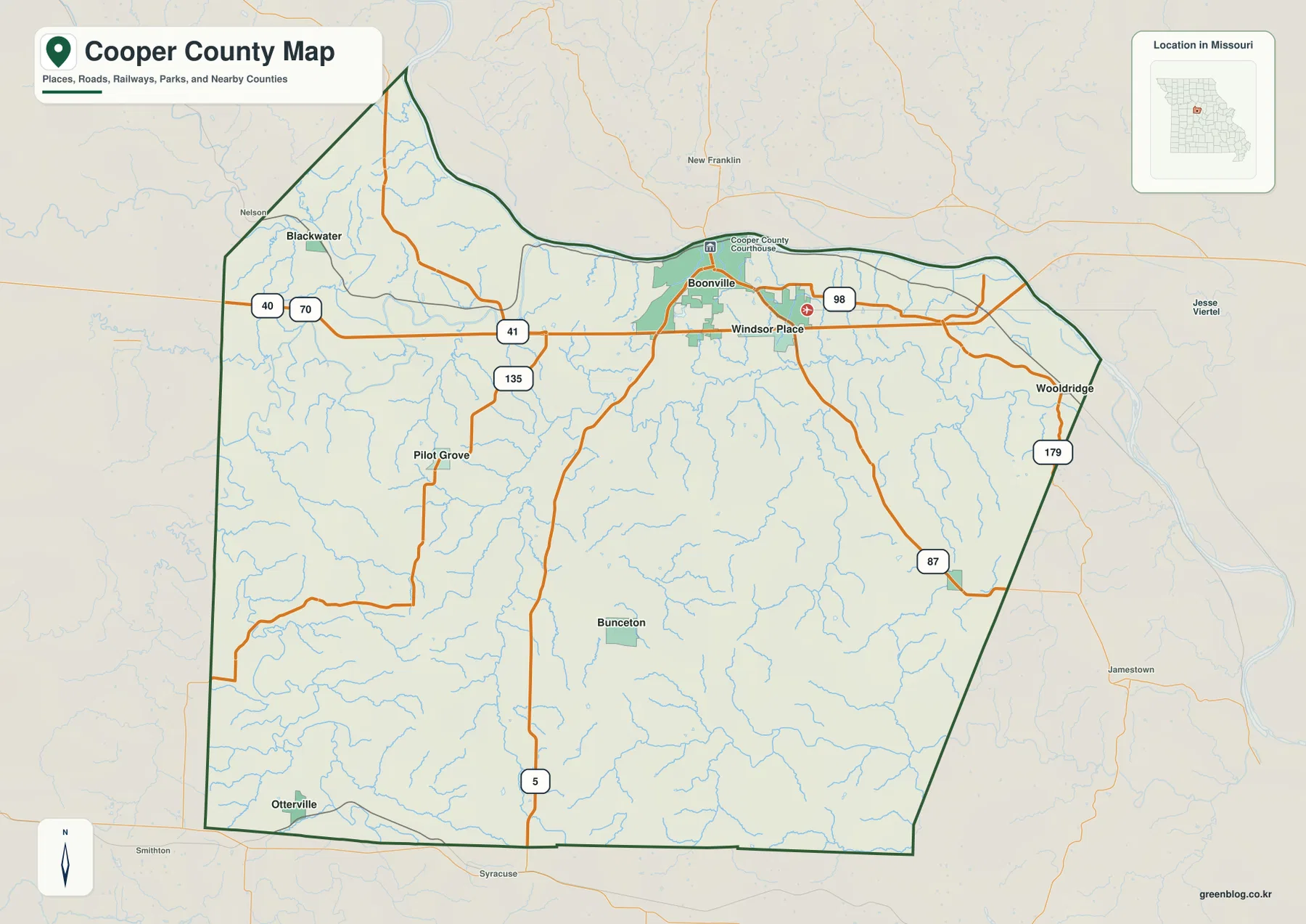
The general county map makes the north-south contrast easy to see. Boonville sits close to the Missouri River in the north, Blackwater and Pilot Grove lie farther west, Bunceton occupies the southern interior, and Otterville appears close to the southwest edge. Wooldridge and Prairie Home are on the eastern side of the county. The arrangement is useful because it shows that Cooper County’s named communities are spread across several parts of the county rather than clustered in one continuous urban area.
Table of Contents
Boonville and the road network
Boonville is the main reference point on the map. The Cooper County Courthouse is marked there, and several numbered routes converge around the northern part of the county. U.S. 40 and U.S. 70 are shown toward the west, while Routes 41, 98, 135, and 179 provide additional orientation. Route 5 runs south through the county toward Bunceton and the southern boundary, giving readers a clear line for comparing northern and southern locations.
West of Boonville, Route 41 and Route 135 help place Pilot Grove, while the U.S. 40 and U.S. 70 shields appear near the Blackwater side of the map. On the east, Routes 87 and 179 help locate Wooldridge and the county’s eastern edge. The map is not a substitute for a live navigation service, but it is very useful for seeing which communities sit near the same road corridors and which ones are separated by larger stretches of rural land.
Six ranked communities
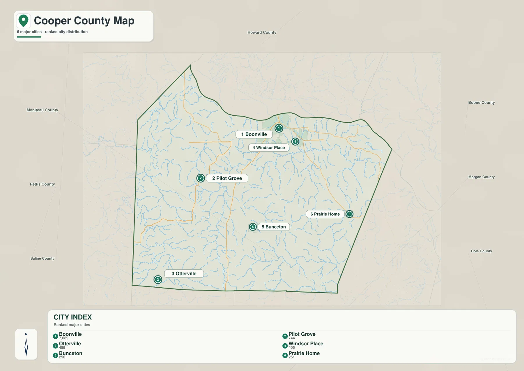
The city distribution map ranks six major communities: Boonville first, Pilot Grove second, Otterville third, Windsor Place fourth, Bunceton fifth, and Prairie Home sixth. These labels are a compact index for the map rather than a complete inventory of every populated place in Cooper County. Boonville and Windsor Place appear relatively close in the north, while Otterville is near the far southwestern portion of the county. That contrast makes the map especially useful for understanding the county’s broad settlement pattern.
Pilot Grove occupies the western interior, Bunceton lies farther south, and Prairie Home sits well to the east. Their positions show why a single ‘center’ does not fully describe Cooper County. Readers can use the numbered markers and the city index together to move quickly between the place names and their positions. Because the map is a ranked distribution map, it should not be read as a chart of road distance or travel time between the communities.
Missouri River and the northern lowlands
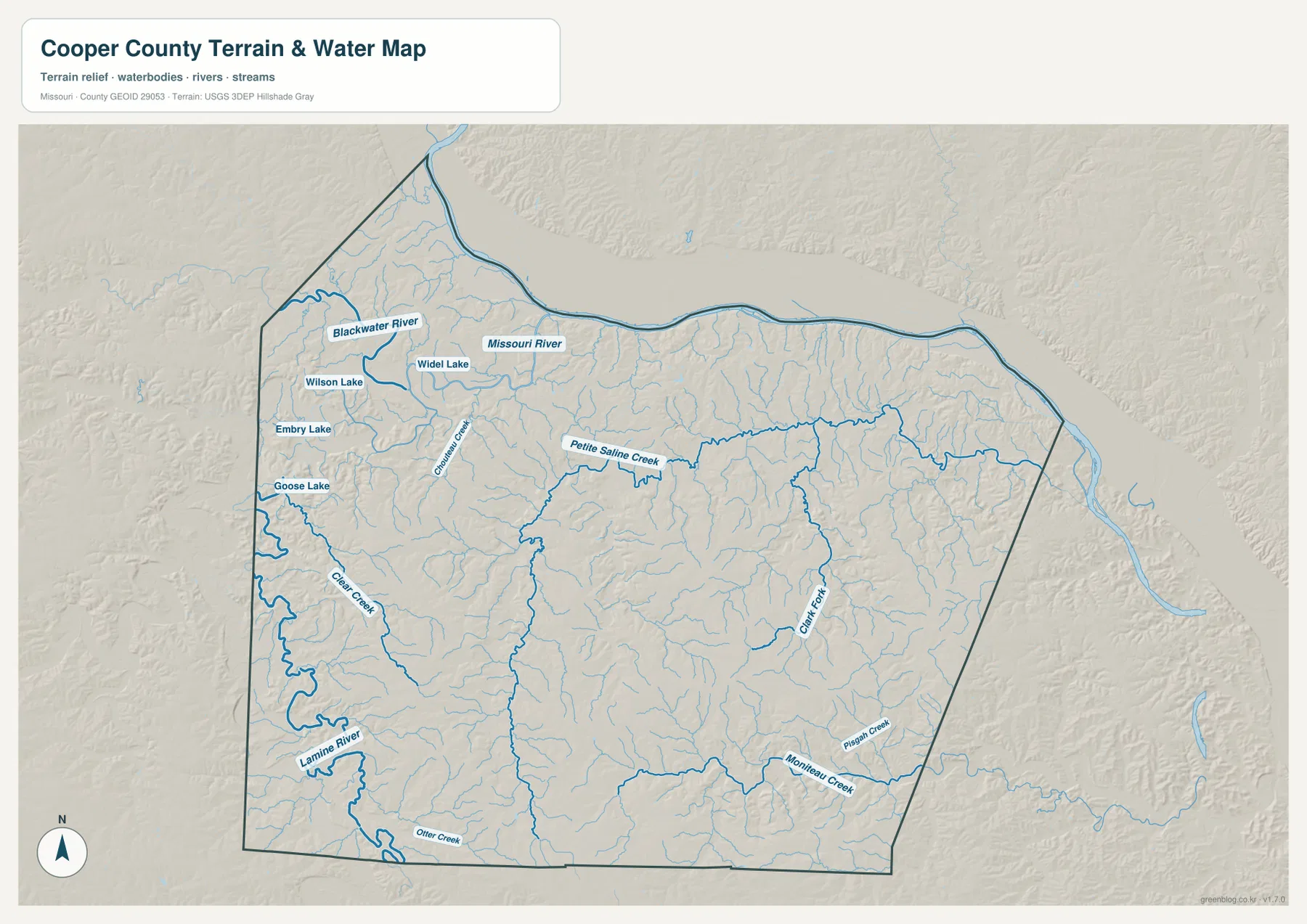
The Missouri River is the largest water feature shown on the terrain-and-water map. It follows the county’s northern edge in a long series of bends and provides a strong geographic reference for Boonville and the northern boundary. When the water map is compared with the elevation map, the river corridor also stands out as one of the lower parts of the county. The contrast helps explain why the northern margin looks different from the higher, more dissected terrain farther south.
Several tributaries add detail to that picture. Blackwater River enters the northwestern portion, while Petite Saline Creek crosses part of the north-central interior. Numerous unnamed and smaller mapped streams branch through the surrounding hills and valleys. Together they reveal a drainage pattern that is not obvious on a road-only map, and they show how the interior terrain is divided by many small channels before water reaches the larger rivers.
Lamine River and southern streams
The Lamine River is a major feature in the southwest. Clear Creek descends through the western side and connects with the low terrain around the Lamine River system, while Otter Creek appears near the southern boundary. Farther east, Moniteau Creek and Pisgah Creek identify additional valleys in the southeastern part of Cooper County. These named waterways make the water map useful for understanding why the southern interior is broken into a series of ridges and drainage corridors rather than forming one broad flat surface.
The map also labels smaller water bodies in the northwest, including Wilson Lake, Embry Lake, Goose Lake, and Widel Lake. They are much smaller than the Missouri or Lamine rivers, but their labels add local detail. Readers interested in a particular part of the county can use these lakes and creeks as landmarks when matching the water map to the general county map or the elevation layer.
Elevation from 160 to 288 meters
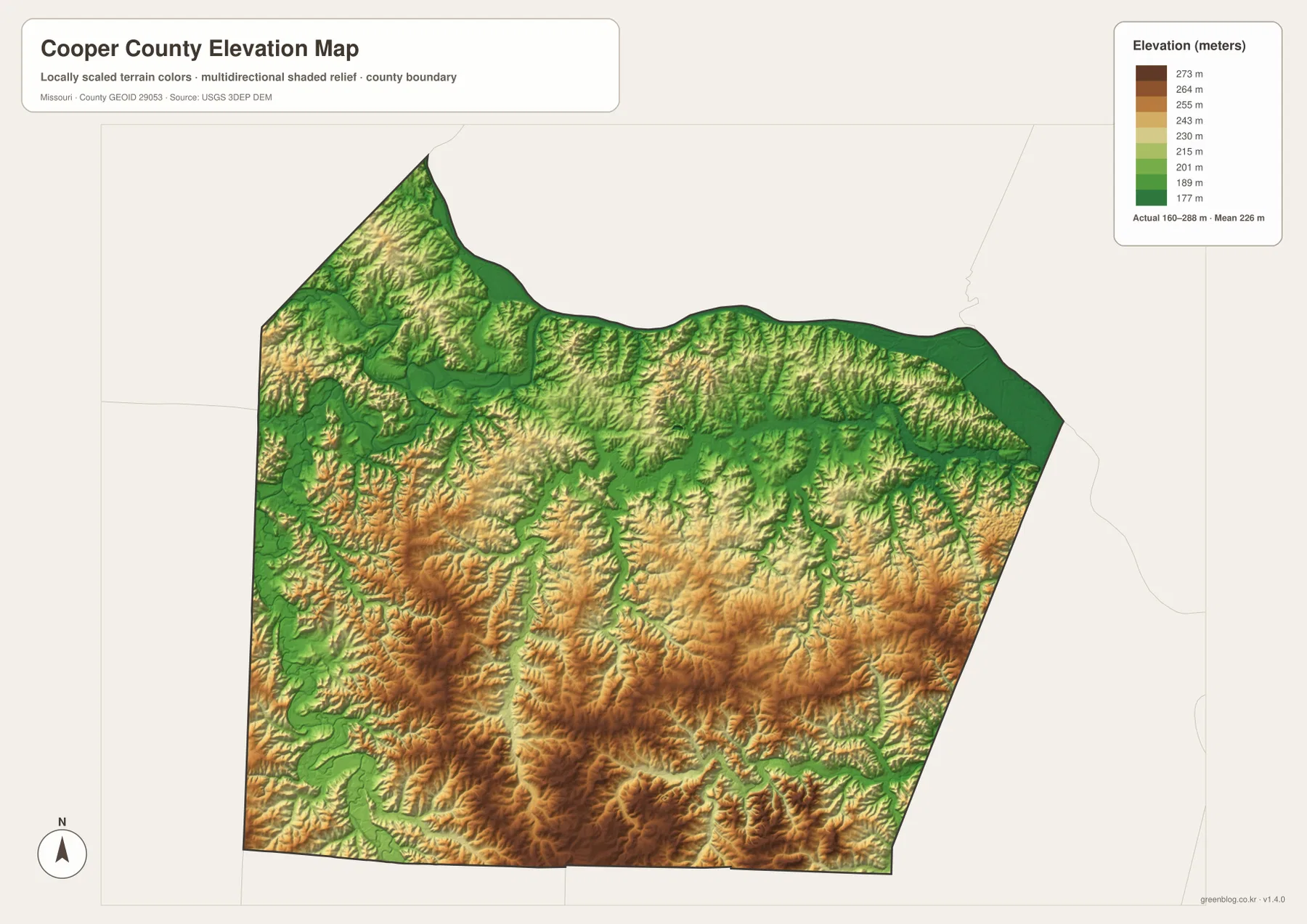
The elevation map gives an actual mapped range of about 160 to 288 meters, with a mean near 226 meters. The lowest elevations are associated with the Missouri River corridor and some larger stream valleys. Higher terrain becomes more prominent through the southern and southwestern interior, where the shaded relief uses tan and brown tones to show a denser pattern of ridges and hills. The map therefore adds vertical context to the same county outline seen on the other maps.
Rather than forming one continuous high ridge, Cooper County’s uplands are divided by many narrow valleys. Green lower ground extends along stream courses, while warmer colors occupy the intervening ridges. This pattern is especially noticeable in the south and southwest. Comparing the shaded relief with the water map makes it easier to see how streams have cut through the higher terrain and why roads sometimes follow broader valleys or ridge tops instead of direct straight lines.
How the four map views work together
Each map emphasizes a different part of the same place. The general map is best for named communities, numbered roads, nearby counties, and the county boundary. The city map simplifies the settlement picture into six ranked communities. The terrain-and-water map highlights the Missouri River, Blackwater River, Lamine River, Petite Saline Creek, and other named streams. The elevation map shows where those waterways sit relative to higher and lower ground.
A practical way to use the set is to start with one familiar place. Find Boonville on the general map, then move to the water map to see its relationship to the Missouri River, and finally compare the elevation layer to the lower river corridor. The same method works for Pilot Grove, Bunceton, or Otterville. Moving between maps turns a place name into a fuller picture of roads, nearby streams, and surrounding relief without forcing too much information into one image.
Using the downloadable files
The downloadable ZIP contains the same four map themes as high-resolution JPG files. They are better suited than the on-page WebP previews for enlarging labels, printing a reference sheet, or placing a map into a personal research document. The files are intended as geographic reference maps, not as real-time navigation, flood warning, or emergency products. Current road closures, weather hazards, or official warnings should always be checked with the appropriate agency.
For a quick city-and-road reference, the general map and city map are usually the most useful pair. For rivers, creeks, and local water bodies, open the terrain-and-water map. For comparing the Missouri River lowlands with the hillier southern interior, use the elevation map. Keeping the files together makes it easy to switch between them without losing the common Cooper County boundary.
Official and local references
Cooper County’s official government website states that the county was organized in 1818 and identifies Boonville as the county seat and largest community. It also names communities such as Blackwater, Otterville, Pilot Grove, Prairie Home, Bunceton, Windsor Village, and Wooldridge. That local reference is useful alongside the maps because many of those same names appear directly on the county and city layers.
The Missouri Department of Conservation describes Lamine River Conservation Area as spanning Cooper and Morgan counties east of Otterville, with access from Highway 50 and Route A. That information provides additional context for the southwestern river landscape shown here. For the underlying geographic themes, readers can also consult the U.S. Census Bureau’s TIGER/Line resources for boundaries and roads, USGS National Hydrography for water features, and the USGS 3D Elevation Program for elevation data.
Frequently Asked Questions
What is the easiest place to use as a reference in Cooper County?
Boonville is the clearest starting point. It sits near the Missouri River on the northern side of the county, includes the marked Cooper County Courthouse, and is close to several numbered routes shown on the general map.
Do the numbers on the city map represent driving distance?
No. The numbers rank six major communities—Boonville, Pilot Grove, Otterville, Windsor Place, Bunceton, and Prairie Home. They are not travel-time or road-distance measurements.
What elevation range does the Cooper County map show?
The elevation layer shows an actual range of about 160 to 288 meters, with a mean near 226 meters. Lower ground is prominent along the Missouri River and larger valleys, while higher hills are more extensive in the southern and southwestern interior.
Map File Information
Download the map files associated with this page for reference, printing, and compatible visual projects.
- Included Files: Use only the versions confirmed in the article and supplied images
- File Type: Use the confirmed download contents
- Intended Use: Printing, education, presentations, and map-based projects
Related Maps
Sources and references
- Cooper County Government – local county background and community information
- Missouri Department of Conservation – Lamine River Conservation Area – context for the Lamine River area east of Otterville
- U.S. Census Bureau TIGER/Line Shapefiles – boundary and road data
- USGS National Hydrography – rivers, streams, and water features
- USGS 3D Elevation Program – elevation data
Green Map creates custom-edited map images using open geographic data sources such as geoBoundaries, Natural Earth, OpenStreetMap, and government open data. These maps are edited visual materials, not raw data files, and are provided for education, documents, presentations, and graphic reference.