Crawford County sits in the Missouri Ozarks southwest of St. Louis, with a northern travel corridor around Cuba and Bourbon and a much rougher interior around Steelville and the Meramec River. The maps on this page place I-44, the Route 66 corridor, Routes 8 and 19, the county’s main communities, named rivers and creeks, and the changing relief within one consistent boundary. High-resolution JPG copies are also available in a single ZIP, so readers can move from the on-page previews to printable or offline files without searching for a separate download.
The county changes character quickly from north to south. Cuba, Bourbon, and the Sullivan side of the county sit near the major east-west highway corridor, while Steelville lies farther inside the Ozark hills. South of Steelville the road network bends repeatedly through narrow valleys and ridges. The water and elevation layers explain much of that shape: the Meramec River crosses the interior in broad bends, smaller streams cut deeply into the hills, and the southern end rises well above the larger river valleys.
Table of Contents
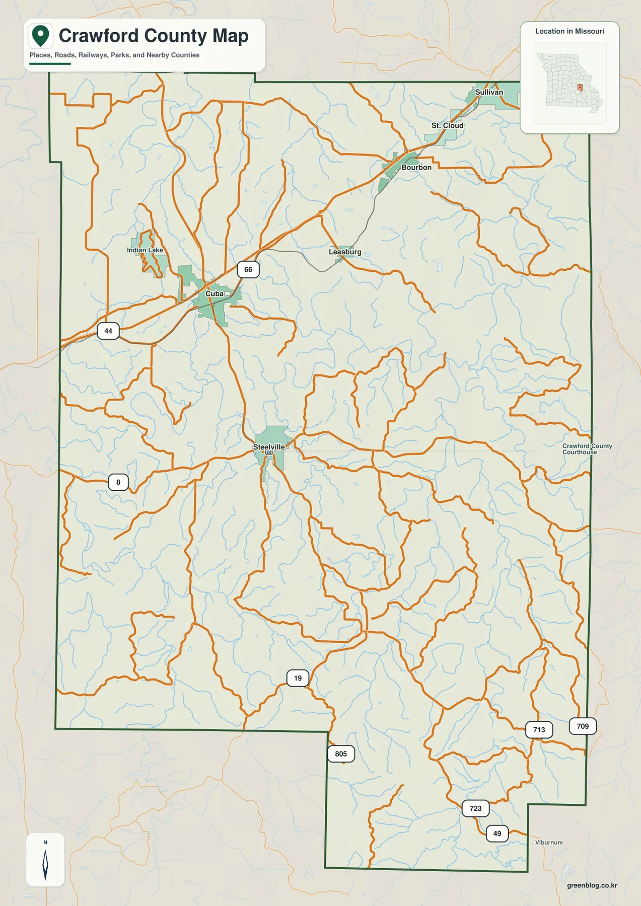
I-44, Route 66, and the Cuba–Bourbon corridor
Cuba is one of the easiest anchors on the general map. I-44 enters from the west, passes the Cuba area, and continues northeast toward Bourbon and Sullivan. A Route 66 marker appears along the same northern corridor, giving readers a familiar historic-road reference in addition to the modern interstate. Leasburg lies southeast of that highway line, while Steelville is farther south, so the county’s northern communities do not form one continuous urban strip.
Crawford County’s official website describes Interstate 44 as the county’s major thoroughfare and places the county roughly 80 miles southwest of St. Louis. That description matches the map’s strongest transportation feature: a long east-west route across the northern part of the county. Once a reader leaves that corridor, roads become smaller and more curved, especially toward the center and south where the terrain is much more deeply dissected.
Steelville as the central county reference
Steelville is the county seat and a useful reference for the middle of Crawford County. Route 8 runs across this part of the map, while Route 19 provides a strong north-south line through Steelville and into the rugged southern interior. The official county history page notes that Steelville was laid out as the county seat in 1836. On the map, its position is also practical because it separates the highway-oriented north from the more winding road pattern to the south.
West of Steelville, Route 8 heads toward the Phelps County side, while roads east of town branch toward the Courtois Creek and eastern Ozark country. Route 19 continues south through increasingly broken terrain. Farther down the map, additional route shields such as 49, 723, and 805 appear among the hills. These roads are useful location markers, but the map should be treated as a county reference rather than a source for current closures, travel times, or turn-by-turn navigation.
Where the six ranked communities sit
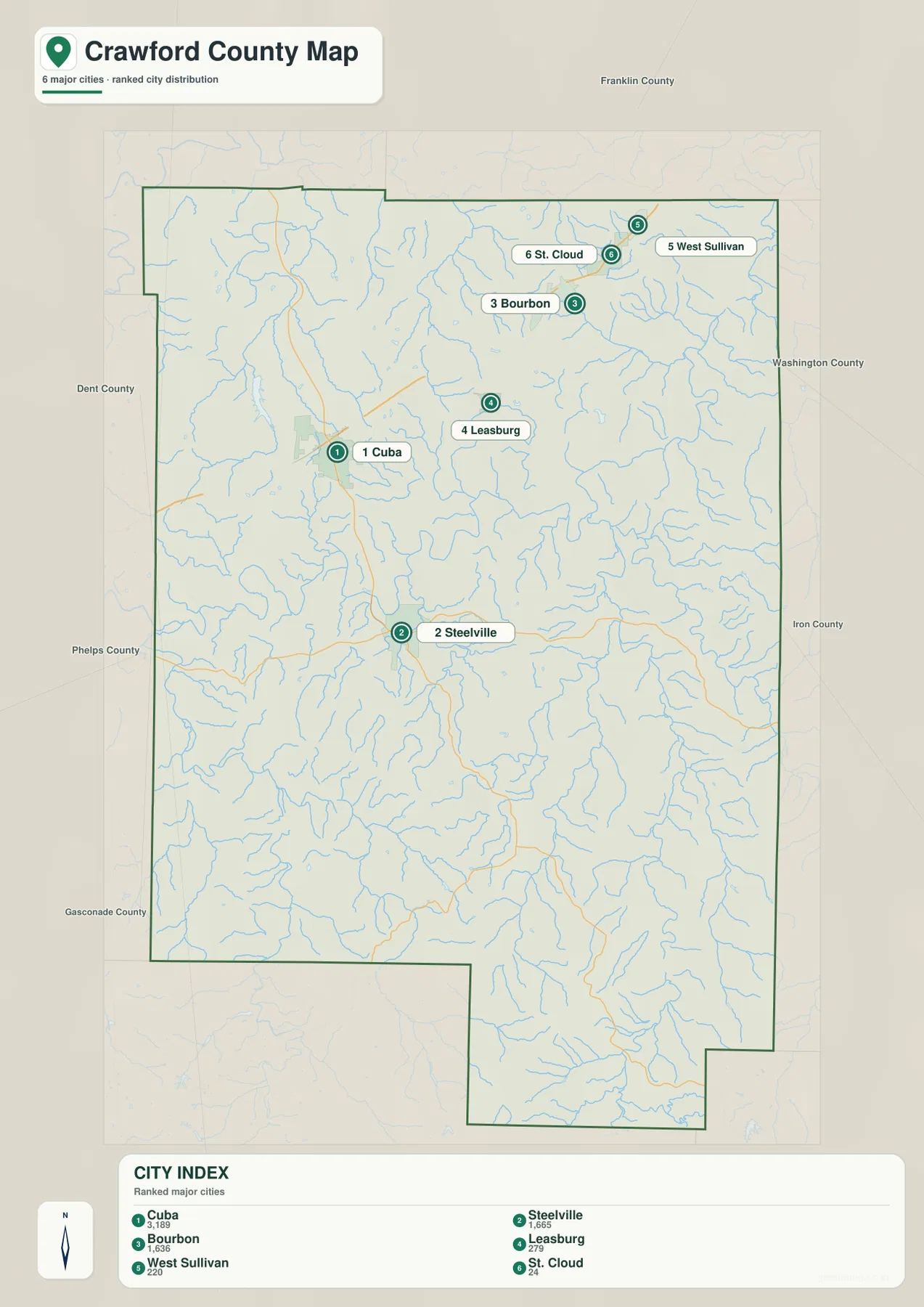
The city distribution map ranks six major communities: Cuba first, Steelville second, Bourbon third, Leasburg fourth, West Sullivan fifth, and St. Cloud sixth. The numbers are a compact way to identify the mapped communities; they are not road distances or travel-time rankings. Cuba occupies the northwestern portion of the settled corridor, Steelville sits distinctly farther south, and Bourbon is northeast of Cuba. Leasburg is between the highway corridor and the interior hills.
West Sullivan and St. Cloud are close to the Franklin County side in the northeast. Their position, together with Bourbon and Leasburg, creates a visible concentration of ranked communities in the northern half of Crawford County. By contrast, the large southern portion has none of the six ranked city markers. That does not mean the south is empty, but it does make the map useful for seeing how the county’s larger named communities are weighted toward the north and center.
The Meramec River across the county interior
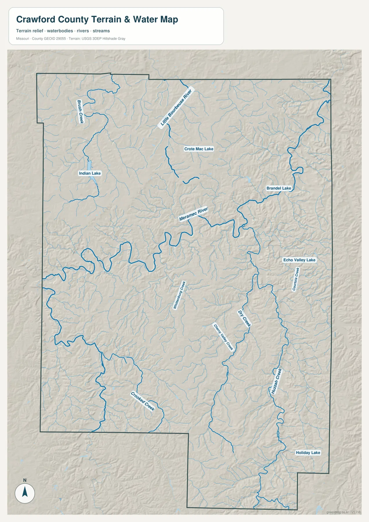
The Meramec River is the dominant water feature on the terrain-and-water map. It enters from the west, makes several broad bends through the central part of the county, and continues toward the east. Its valley forms a long low corridor that is easy to match with the green tones on the elevation layer. Smaller streams feed the river from both north and south, revealing a much more intricate landscape than the road layer alone can show.
North of the Meramec, the Little Bourbeuse River and Brush Creek are labeled among a dense network of smaller tributaries. To the east and southeast, Courtois Creek, Dry Creek, and Hinman Creek stand out as longer named channels. Crooked Creek and Cherryville Creek add more detail in the southern interior. The water map is intended for geographic reference; it should not be used as a flood-hazard determination, property-boundary source, or navigation chart.
Lakes and smaller streams as local landmarks
Several smaller water bodies are labeled as well, including Indian Lake, Brandel Lake, Echo Valley Lake, and Holiday Lake. Indian Lake is particularly easy to relate to the road map because it lies near the Cuba side of the county. Brandel Lake and Echo Valley Lake provide useful landmarks farther east, where the hills and drainage lines become harder to distinguish from one another on a simple road map.
A practical way to read the water layer is to start with the Meramec River and then work outward. The Little Bourbeuse River identifies the north-central drainage, Courtois Creek helps orient the eastern interior, and Crooked Creek helps with the south. This hierarchy keeps the many thin blue tributaries from becoming overwhelming. It also makes it easier to connect named natural areas with the valleys visible on the shaded terrain base.
Relief from 175 to 421 meters
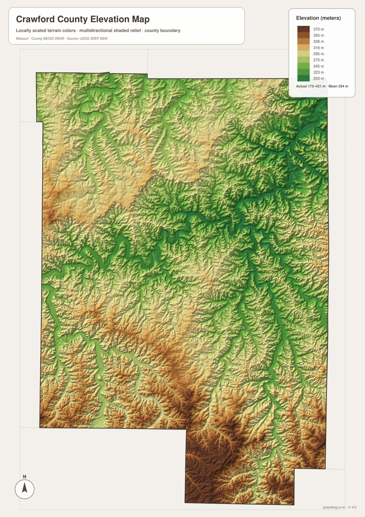
The elevation map shows an actual county range of about 175 to 421 meters, with a mean near 284 meters. The lowest ground follows the Meramec River and other larger stream valleys, where green colors trace long, branching corridors. Higher areas appear in yellow, tan, and brown. The southern and southeastern portions contain some of the most extensive high ground, creating a sharp visual contrast with the river valleys in the central part of the county.
Crawford County is not shaped like a single flat plateau. Narrow ridges are repeatedly cut by creeks, and the shaded relief makes those small changes visible across nearly the entire map. South of Steelville, high ridges and deeply incised valleys become especially prominent. Comparing that surface with the road map helps explain why many routes bend through the Ozark landscape instead of following long straight lines across the county.
Huzzah, Courtois, and the eastern Ozark country
The eastern and southeastern side of Crawford County contains some of the county’s best-known rugged river country. The Missouri Department of Conservation describes Huzzah Conservation Area as a Crawford County landscape of forested hills, the Meramec River, Huzzah Creek, and Courtois Creek. Courtois Creek is labeled on the supplied water map, and its valley provides a useful geographic reference for this part of the county.
Onondaga Cave State Park near Leasburg offers another real-world connection between the mapped rivers and the Ozark terrain. Missouri State Parks highlights both the cave system and the Vilander Bluff Natural Area overlooking the Meramec River. Those details help explain why the map’s river valleys and steep relief matter beyond cartography. For park boundaries, trails, access points, or temporary closures, however, the current park and conservation-area maps are the better sources.
Reading roads, water, and elevation together
A useful map-reading exercise is to start at Cuba on the general map and trace the county south toward Steelville. The city map shows how the two communities occupy different parts of the county, the water layer reveals the creeks and the Meramec system between them, and the elevation layer adds the surrounding ridges. Following the same places through each layer turns a collection of labels into a clearer picture of how the county is organized.
The same method works on the east side. Bourbon and Leasburg are easiest to locate from the road network, but Courtois Creek and the Meramec River provide better references for the surrounding terrain. In the south, Route 19 and the smaller route shields become more meaningful when viewed beside the elevation map’s high ridges and narrow green valleys. Because all four views use the same county outline, switching between them is straightforward.
Using the high-resolution JPG files
The download ZIP contains high-resolution JPG versions of the general county map, ranked communities map, terrain-and-water map, and elevation map. They are better suited than the WebP previews for enlarging labels, printing a reference sheet, preparing a classroom handout, or keeping an offline county reference. The files are not survey products and do not replace current navigation, flood warnings, parcel records, or engineering-grade elevation data.
For community names and numbered roads, begin with the general map and city distribution map. The terrain-and-water map is the better choice when the question involves the Meramec River, named creeks, or lakes. The elevation layer is most useful for comparing low valleys with the higher southern Ozark country. Keeping the four files together makes it easy to move between topics without losing the common Crawford County boundary.
Frequently Asked Questions
What is the county seat of Crawford County, Missouri?
Steelville is the county seat. Crawford County’s official history page states that Steelville was laid out as the county seat in 1836, and the supplied county map shows it near the intersection of Routes 8 and 19 in the central part of the county.
Do the numbers on the city map show driving distance?
No. They rank six major mapped communities: Cuba, Steelville, Bourbon, Leasburg, West Sullivan, and St. Cloud. The numbers do not represent mileage or travel time, so current road directions should come from a navigation or transportation source.
What elevation range is shown for Crawford County?
The elevation map shows an actual range of about 175 to 421 meters and a mean near 284 meters. Lower elevations follow the Meramec River and larger creek valleys, while much of the southern and southeastern interior rises into higher Ozark ridges.
Map File Information
Download the map files associated with this page for reference, printing, and compatible visual projects.
- Included Files: Use only the versions confirmed in the article and supplied images
- File Type: Use the confirmed download contents
- Intended Use: Printing, education, presentations, and map-based projects
Related Maps
Sources and references
- Crawford County, Missouri – About – official county background, I-44, establishment, and Steelville information
- Missouri Department of Conservation – Huzzah Conservation Area – Meramec River, Huzzah and Courtois creek country, and rugged Ozark terrain
- Missouri State Parks – Onondaga Cave State Park – cave, bluff, and Meramec River context near Leasburg
- U.S. Census Bureau TIGER/Line Shapefiles – county boundaries and road data
- USGS National Hydrography – rivers, streams, and water features
- USGS 3D Elevation Program – elevation data
Green Map creates custom-edited map images using open geographic data sources such as geoBoundaries, Natural Earth, OpenStreetMap, and government open data. These maps are edited visual materials, not raw data files, and are provided for education, documents, presentations, and graphic reference.