Winona County follows the Mississippi River through southeastern Minnesota, but the county is much more than a narrow river strip. Winona and Goodview occupy low ground close to the river, while Lewiston and St. Charles sit farther inland among broad uplands and deeply cut valleys. Rollingstone and Stockton provide smaller reference points between those areas. This page separates roads and settlements, city distribution, waterways, and elevation into four views, and the high-resolution JPG originals can be downloaded together in the ZIP box below. High-resolution map files are available for download in the section below.
The most distinctive feature is the abrupt change between the Mississippi River lowlands and the interior ridge country. Near Winona, the terrain drops toward the river and backwaters. A short distance inland, steep-sided valleys and narrow ridges appear around Rollingstone Creek, the Whitewater River system, Garvin Brook, and many smaller streams. The elevation map reinforces that contrast with a range from about 192 to 416 meters and a county mean near 329 meters.
Table of Contents
Winona links the Mississippi corridor to U.S. 14 and the interior
Winona is the easiest place to begin on the general map. The city lies beside the Mississippi River, with Goodview immediately to the west. U.S. 61 follows the river corridor through the eastern part of the county, while U.S. 14 leaves the Winona area and heads inland toward Stockton and Lewiston. Minnesota 43 runs south from Winona into the interior. Together, those routes explain how the county’s largest city connects a low river setting with higher inland communities.
Continuing west on U.S. 14 brings Stockton first and Lewiston farther inland. Minnesota 248 crosses the northern interior between the Altura and Rollingstone areas, and Minnesota 74 serves the northwestern side near Elba. South of the main east–west road, Minnesota 43 and Minnesota 76 extend through a landscape that is broken by numerous stream valleys. The roads are therefore less grid-like than they might appear at first glance; many bends reflect the shape of the terrain.
At the southeastern end, U.S. 61 continues along the Mississippi toward Dakota and La Crescent. I-90 is also marked in the broader road network and serves the southern part of the region. The general map is useful for identifying the county boundary, communities, and major route directions, but it is not a live navigation product. Current construction, closures, and driving conditions should be checked with transportation services before a trip.
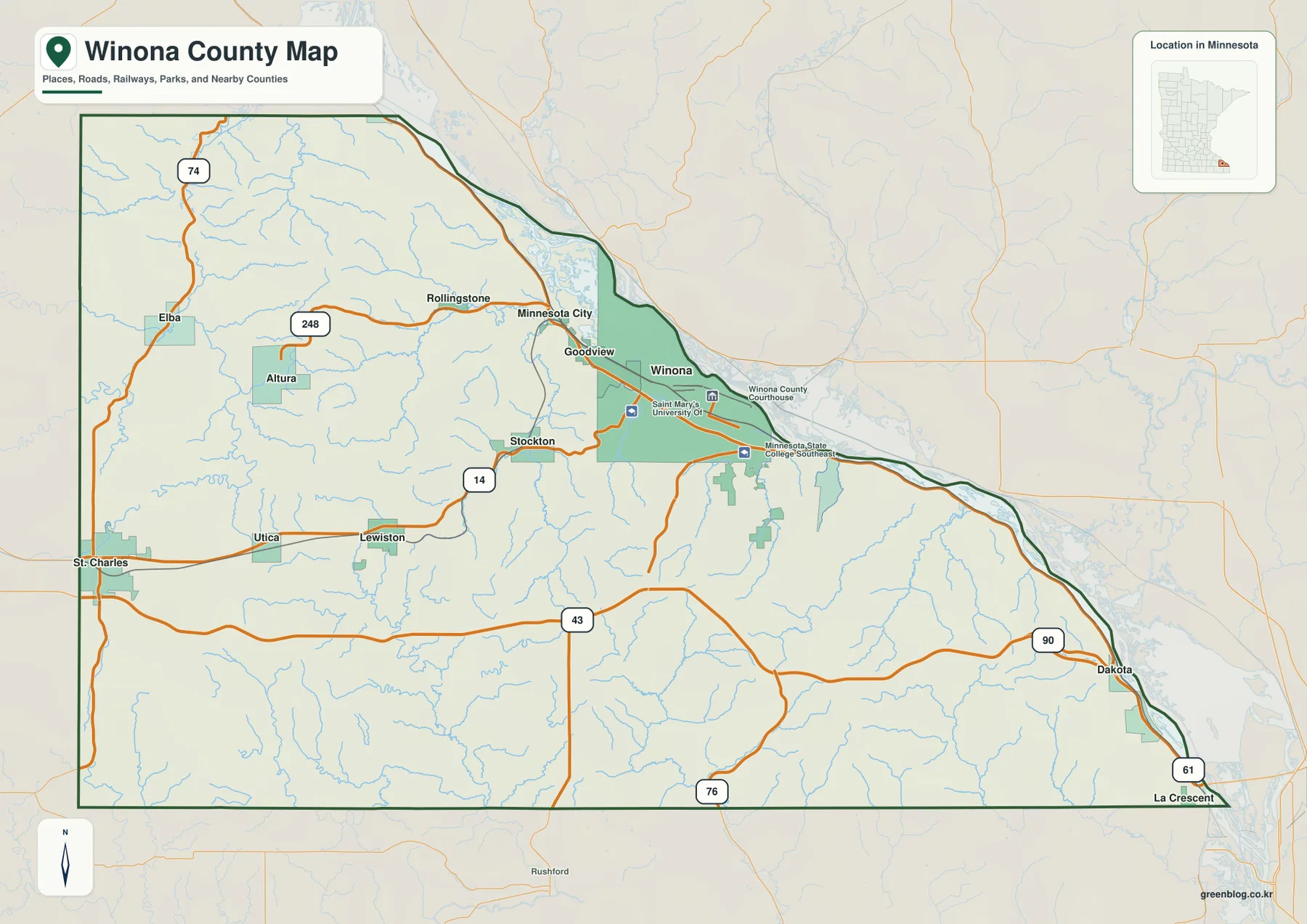
The county outline itself is a clue to the landscape. The northeastern and eastern edge bends with the Mississippi River, while the southern and western sides are straighter. Settlement follows that geography. Winona and Goodview occupy the broad river-side lowland; St. Charles, Lewiston, and Altura are more widely spaced inland. As a result, eastern Winona County looks concentrated around one major city and the river, while the western half appears more open and rural.
Six highlighted cities show a strong Winona-centered pattern
The city map highlights six communities with reference values in its CITY INDEX: Winona 26,009, Goodview 4,103, St. Charles 4,037, Lewiston 1,613, Stockton 811, and Rollingstone 620. These figures are useful for comparing the relative size of the places shown on this particular map. They should not be treated as a replacement for a current official population table when the latest Census estimate or count is needed.
Winona stands apart from the other five communities in both size and position. Goodview sits immediately west of Winona in the same broad river-side area, and Rollingstone lies farther northwest in a narrow valley setting. Stockton and Lewiston extend the urban reference westward along the U.S. 14 corridor. St. Charles, near the western side of the county, forms the most distant major point in this group.
The distribution is important because it is not a simple chain of equally spaced towns. The Winona–Goodview area is concentrated along the Mississippi, while the smaller inland cities are separated by ridges, farms, and stream valleys. Stockton works as a middle reference between Winona and Lewiston, and Rollingstone occupies a different valley north of that line. The map is most useful for showing relative positions rather than road distance.
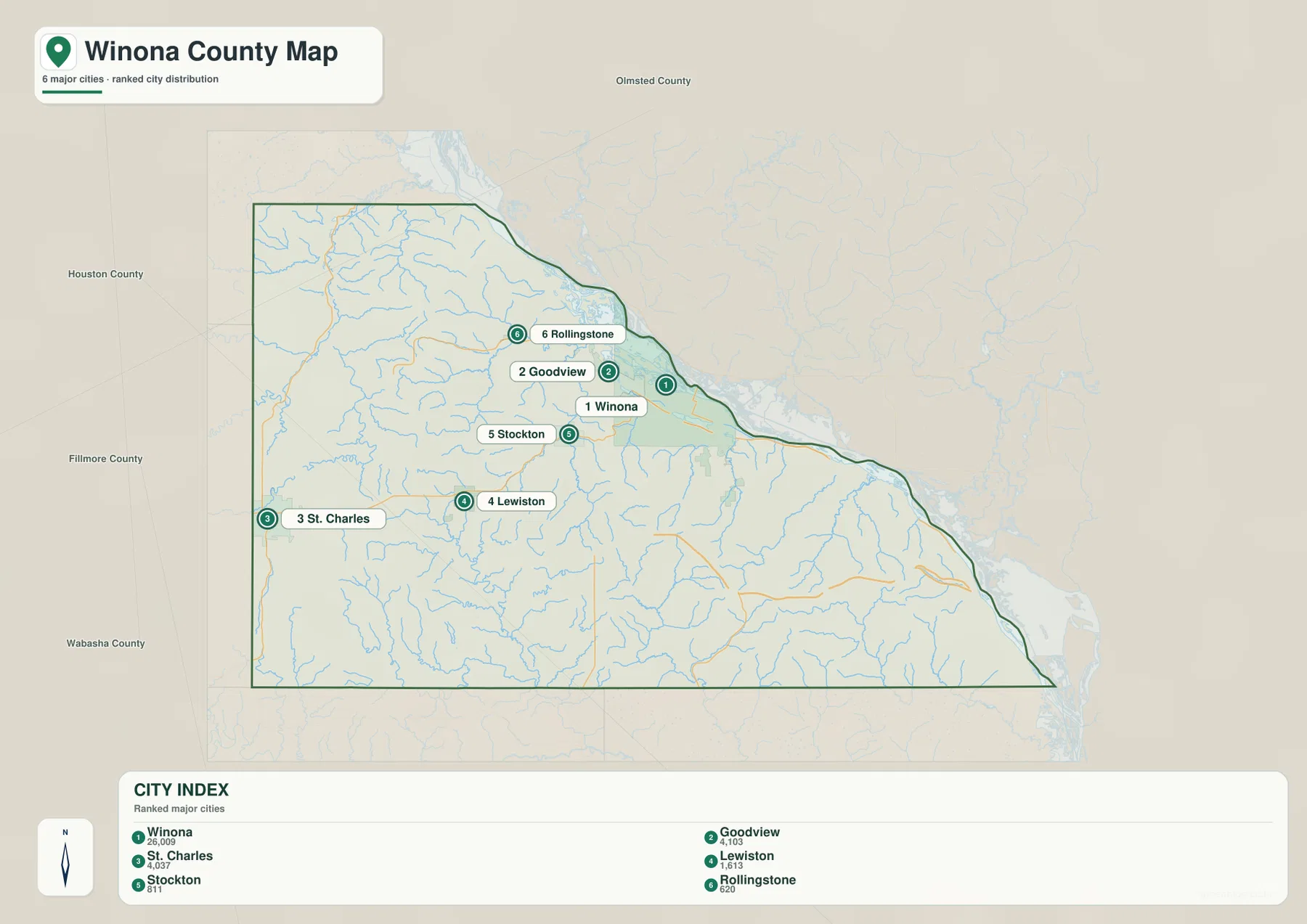
Because the city view omits many roads and smaller places, it should be paired with the general map when planning actual travel. A short straight-line gap on the city map can involve a more complicated route once ridges and valleys are considered. The simplified view is best for understanding where the six highlighted communities sit within the county and how strongly the settlement pattern is weighted toward Winona.
Mississippi backwaters meet the Whitewater and creek valleys
The Mississippi River dominates the northeastern edge of the water map. Around Winona, the river broadens into channels, backwaters, and low-lying water areas. Lake Winona and Lake Goodview are labeled close to the city, and Lake Onalaska appears farther southeast beyond the county edge. This river-side water landscape contrasts with the narrow, branching streams that cut the interior uplands.
In the northwestern interior, the Whitewater River and South Fork Whitewater River run through sharply defined valleys. Rollingstone Creek follows another valley toward the Mississippi, and Garvin Brook appears west of Winona. These streams are much smaller than the Mississippi but are especially useful for reading the terrain because their courses trace some of the deepest cuts through the uplands.
Farther south, Rush Creek, Money Creek, Golden Creek, Pine Creek, and Trout Run are among the named waterways visible on the map. Many smaller tributaries connect to them. Rather than one broad drainage corridor, the southern half contains repeated narrow valleys that divide the higher ground into ridges. That branching pattern is one reason the terrain map looks so textured even where the road map appears relatively open.
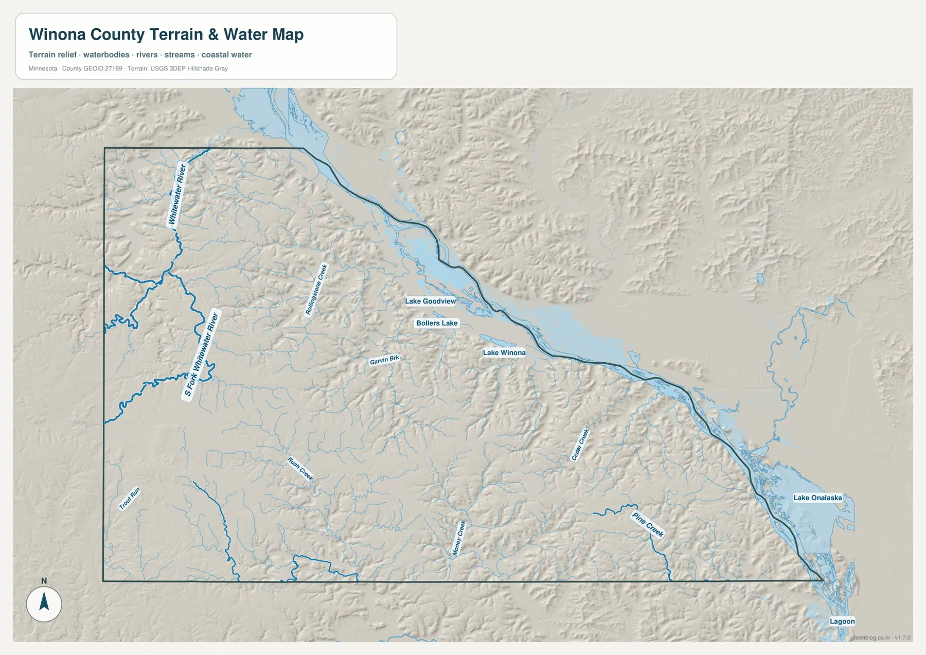
This water map is intended for geographic orientation, not for flood-risk, water-depth, water-quality, or boating decisions. Mississippi River levels and backwater conditions can change, and specialized official sources are required for safety or property questions. For ordinary map reading, a useful sequence is to locate Winona and Lake Winona first, then trace Rollingstone Creek and the Whitewater River system into the higher interior.
A 192–416 meter range creates dramatic relief near the river
The elevation legend gives an actual range of about 192 to 416 meters and a mean near 329 meters. The lowest green band follows the Mississippi River and includes the broad lowland around Winona. Moving inland, the colors shift rapidly through lighter greens and yellows into tan and dark brown. This quick change shows that high ground rises close to the river rather than gradually over a long distance.
West and northwest of Winona, narrow green valleys repeatedly cut through higher brown terrain. The Whitewater River system and Rollingstone Creek occupy some of these lower corridors, while steep ridges rise on both sides. The same pattern continues southeast along the Mississippi edge: the river plain remains low, but the interior is broken into a dense network of elevated ridges and tributary valleys.
Large parts of the south-central and southwestern interior rise above 350 meters, and the highest areas approach 416 meters. The Mississippi and major stream valleys can fall near the 200-meter range. A vertical difference of more than 200 meters within one county is substantial, and it explains why the shaded relief has such strong contrast. Winona County is therefore not a gently sloping plain; it is a deeply dissected upland beside a major river.
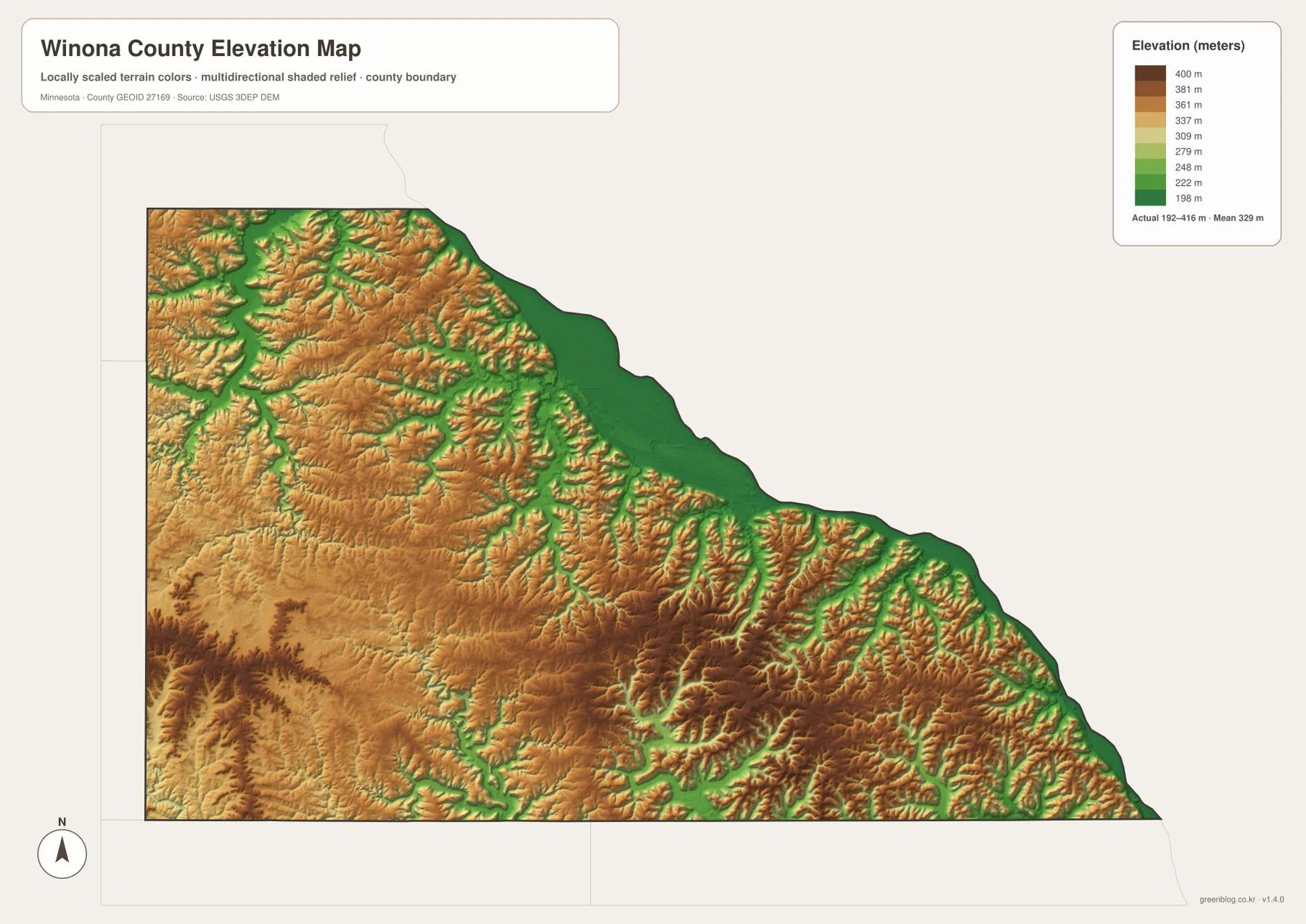
The elevation surface is generalized for county-scale comparison. It should not be used to determine the exact height of a parcel, road grade, building site, or drainage structure. Those uses require source elevation data, field checks, and surveying where appropriate. For general readers, the image is most helpful for understanding why Winona occupies a low river setting while the country around Lewiston, St. Charles, and the interior creeks is much higher.
A practical sequence for reading all four Winona County views
Start with Winona and the Mississippi River on the general map. Add Goodview just west of the city, then follow U.S. 14 inland through Stockton to Lewiston. Place St. Charles farther west and Rollingstone northwest of Winona. Once those reference points are fixed, the county’s long river edge and wider inland half become much easier to understand.
Next, compare the water map. Locate Lake Winona, then trace Rollingstone Creek, Garvin Brook, the Whitewater River system, and smaller southern creeks. The same locations on the elevation map appear as low green corridors surrounded by tan and brown ridges. Matching water and relief reveals the county’s defining relationship: streams have cut deep valleys through high ground on their way toward the Mississippi.
Use the general map for roads, named places, and the county boundary. The city map is best for comparing the six highlighted communities without extra detail. Choose the water map for rivers, creeks, and lakes, and the elevation map for the 192–416 meter relief and ridge pattern. Keeping the four roles separate makes each image easier to read for printing, classwork, presentations, or personal reference.
Frequently Asked Questions
Where is Winona within the county?
Winona lies on low ground beside the Mississippi River in the northeastern part of the county. Goodview is immediately west, U.S. 61 follows the river corridor, and U.S. 14 heads inland toward Stockton and Lewiston. The general and elevation maps together show the city’s river-side setting clearly.
What elevation range is shown for Winona County?
The elevation legend reports an actual range of about 192 to 416 meters and a mean near 329 meters. The Mississippi River corridor is the lowest part of the map, while interior ridges rise well above 350 meters and some areas approach the upper end of the range.
Which inland waterways are useful landmarks?
The Whitewater River and South Fork Whitewater River are prominent in the northwestern interior. Rollingstone Creek and Garvin Brook provide additional references near Winona, while Rush Creek, Money Creek, Golden Creek, Pine Creek, and Trout Run help trace the southern valley network.
Map File Information
The ZIP contains the high-resolution JPG originals of the Winona County general map, city map, water map, and elevation map shown on this page.
- Included Files: 4 high-resolution JPG maps
Related Maps
Sources and references
- U.S. Census Bureau TIGER/Line Shapefiles — county boundaries and geographic reference data
- USGS National Hydrography — rivers, streams, and water features
- USGS 3D Elevation Program — elevation and terrain reference data
Green Map creates custom-edited map images using open geographic data sources such as geoBoundaries, Natural Earth, OpenStreetMap, and government open data. These maps are edited visual materials, not raw data files, and are provided for education, documents, presentations, and graphic reference.