Redwood County sits in southwestern Minnesota, and its maps become much easier to read once two reference points are established: Redwood Falls near the northeastern side and the U.S. 14 communities along the south. Between them, the Redwood River crosses the county toward Lake Redwood and the Minnesota River, while the Cottonwood River follows a separate course across the southern portion. Wabasso, Morgan, Walnut Grove, Lamberton, Belview, and several smaller communities are spread across a broad rural landscape rather than packed into one continuous urban area.
This page brings together a general county map, a ranked six-city map, a terrain-and-water map, and an elevation map. The WebP versions can be viewed in the article, and the original 3638×2572-pixel JPG files are also available together in a downloadable ZIP. That makes the set useful for a printed reference, classroom handout, presentation, or a closer look at roads, rivers, settlements, and terrain without relying on a single crowded image.
Table of Contents
Start at Redwood Falls to understand the county outline and road network
Redwood Falls lies near the northeastern side of the county, where Minnesota Highway 19 crosses from west to east and U.S. Highway 71 turns south. Highway 67 runs southeast toward Morgan, while Highway 68 crosses the west-central part of the county through the Lucan and Wabasso area. Farther south, U.S. Highway 14 provides another strong reference line through Walnut Grove, Revere, Lamberton, and the Sanborn area. These roads make it possible to place most of the named communities without treating Redwood Falls as if it were in the geographic center.
The county boundary itself is distinctive. A northern projection contains Belview and Delhi, then the upper edge bends southeast along the Minnesota River. The southeastern side steps inward before the boundary reaches the southern tier. Neighbor labels around the map include Lyon, Yellow Medicine, Cottonwood, Renville, Brown, Murray, and Nicollet counties, giving enough regional context to see how Redwood County fits into the southwestern Minnesota county pattern.
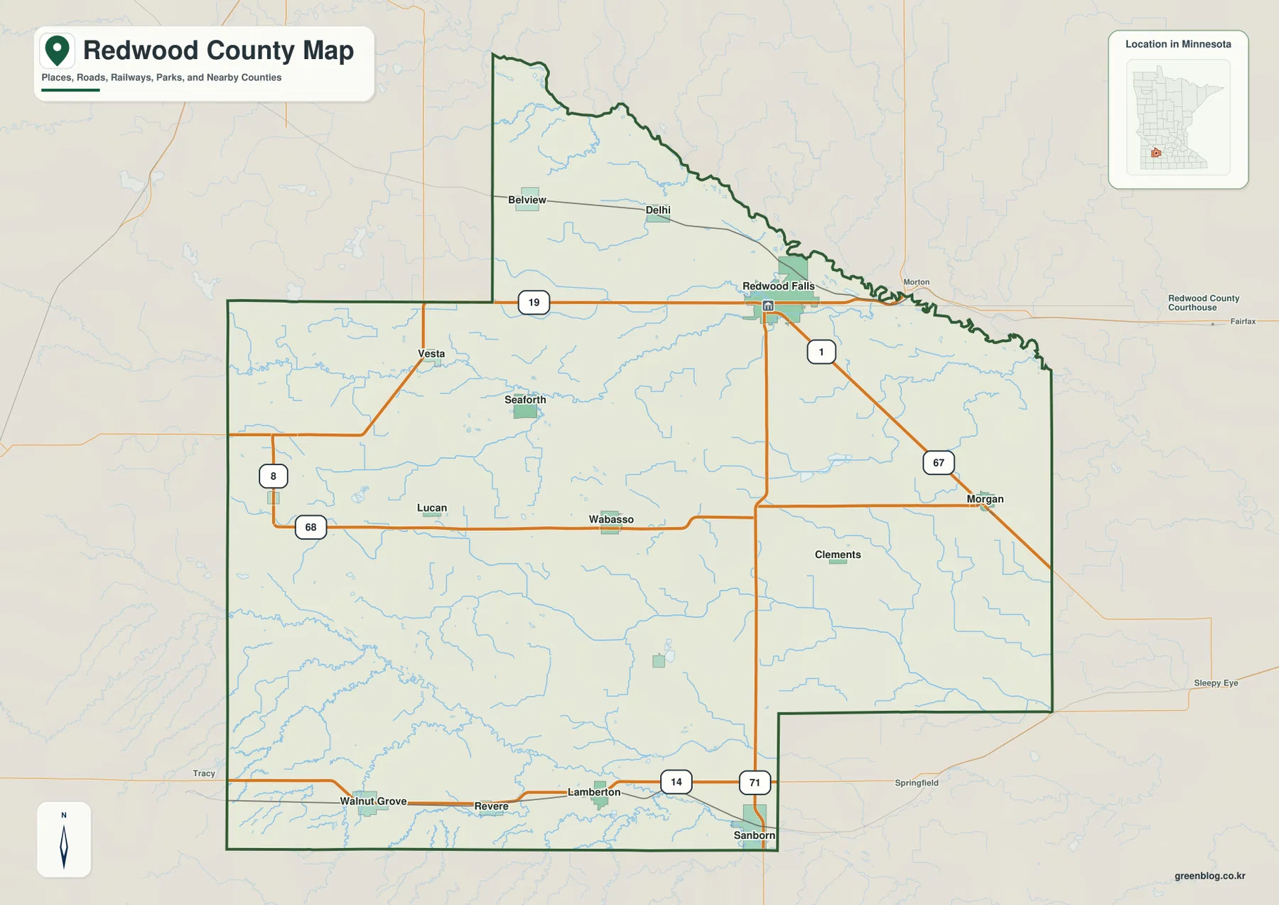
Smaller communities fill in the spaces between those routes. Vesta and Seaforth lie west of the county center, Lucan is farther southwest, and Clements sits east of the central area. The road map is therefore useful not just for finding the largest city but for seeing how a network of small communities relates to the main state and U.S. highways. It also shows why the south can feel like a separate travel band from the Redwood Falls area: U.S. 14 runs across the bottom while Highway 19 carries traffic through the north.
The orange road lines are a geographic reference, not a live navigation layer. They do not indicate current closures, lane counts, traffic volumes, construction schedules, or detours. For trip planning, current transportation sources remain necessary. For orientation, however, the combination of road numbers, community names, and the county boundary gives a clear first view of where the major places are located.
The six-city view separates Redwood Falls from the smaller centers
The ranked city map selects six communities: Redwood Falls, Morgan, Lamberton, Walnut Grove, Wabasso, and Belview. The displayed values are 5,068 for Redwood Falls, 925 for Morgan, 917 for Lamberton, 808 for Walnut Grove, 603 for Wabasso, and 362 for Belview. These numbers are the values shown by the city index used on this map. They should not be interpreted as mileage, driving time, municipal land area, or a measurement between city markers.
Redwood Falls is ranked first and is positioned near the northeastern edge. Morgan occupies the eastern side, Wabasso sits west of center, and Belview is in the northern projection. Walnut Grove and Lamberton form the southern pair near U.S. 14. Looking only at those six points reveals a useful contrast: one prominent center in the northeast and a set of smaller places distributed across the west, east, north, and south rather than clustered around Redwood Falls.
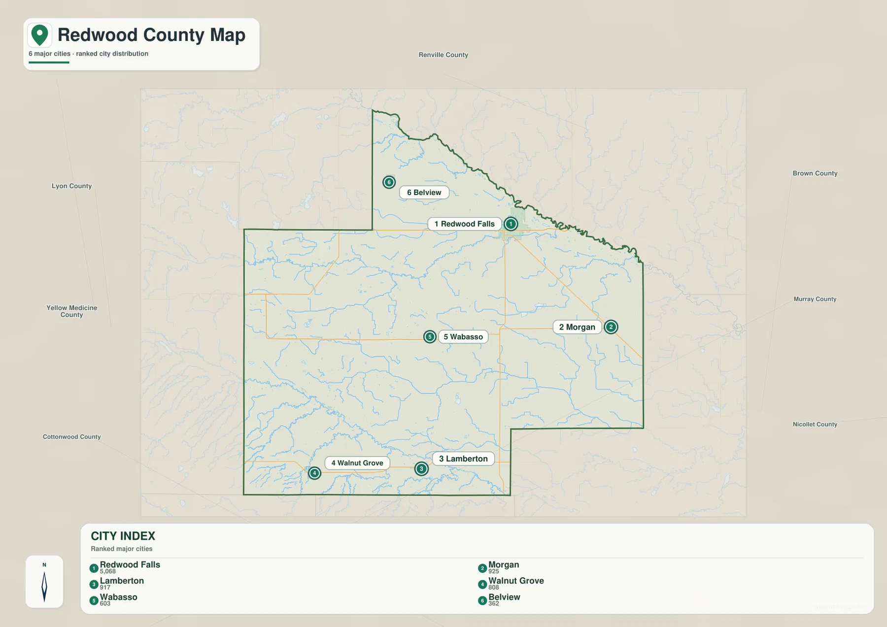
The simplified city image is deliberately selective. Delhi, Vesta, Seaforth, Lucan, Clements, Revere, and Sanborn appear on the general map but are not part of the six-city ranking. That makes the city version cleaner for comparing selected centers, while the general county map remains better when smaller communities and road relationships matter. Switching between the two prevents the city index from being mistaken for a complete settlement map.
Three river corridors organize the county from north to south
The Minnesota River is the dominant water feature along the northeastern boundary. The Redwood River enters from the west, crosses the central portion of the county, and reaches Lake Redwood before continuing toward the Redwood Falls area and the Minnesota River valley. This relationship is more obvious on the terrain-and-water map than on the road map because the river channels and the broad valley edge are visually emphasized instead of competing with highway labels.
The southern half follows a different set of waterways. The Cottonwood River crosses the south, while Sleepy Eye Creek and Gales Lake appear toward the southwest. Plum Creek, Pell Creek, and Dutch Charley Creek are also labeled in the southern section. Near the middle of the county, Daubs Lake and Willow Lake provide additional reference points, and the eastern side includes Wabasha Creek and Judicial Ditch No. 30. Judicial Ditch No. 36 is marked farther west, showing that many smaller channels occupy the land between the major rivers.
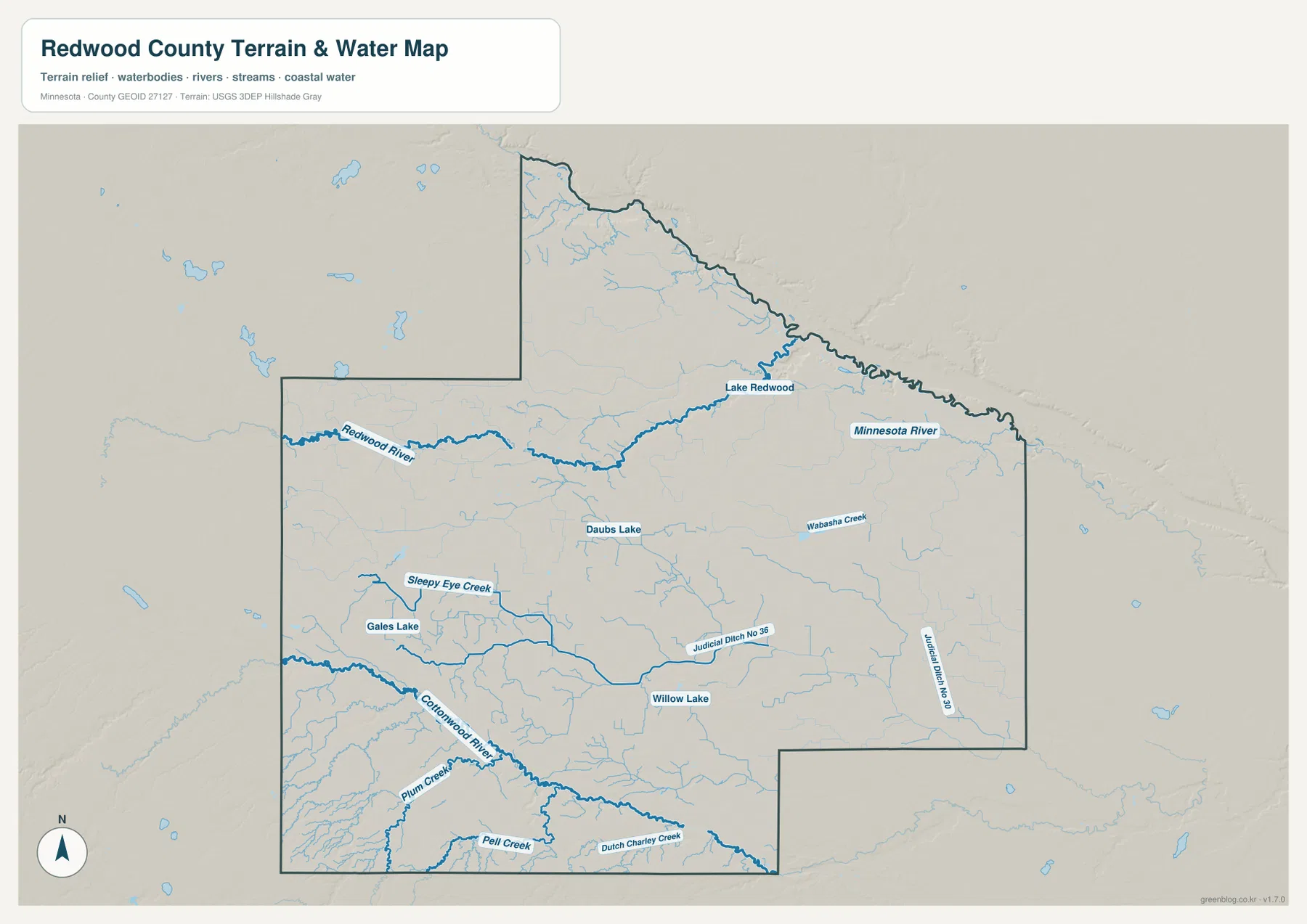
The Redwood and Cottonwood rivers both cross broad portions of the county, but they serve different parts of the landscape. The Redwood River is closely tied to the route toward Redwood Falls and Lake Redwood, whereas the Cottonwood River stays farther south, below the U.S. 14 communities. This is useful when comparing Walnut Grove or Lamberton with Redwood Falls: the cities belong to different road corridors, and they also sit near different river valleys.
The map should be used for location and geographic context rather than for conclusions about water conditions. A blue line does not indicate navigability, flood probability, water quality, depth, or legal drainage rights. Those questions require current specialized sources. For a county overview, the map is most helpful when tracing the Redwood River to Lake Redwood and the Minnesota River, then comparing that route with the separate Cottonwood River corridor to the south.
Elevation rises toward the southwest and falls into the Minnesota River valley
The elevation map shows an overall range of about 246 to 443 meters and a displayed mean of roughly 327 meters. The warmest brown tones are concentrated in the southwest, while much of the central and western county appears in intermediate yellow-green and light-green shades. Redwood County is not mountainous, yet the map makes a broad change in height visible across a landscape that can look comparatively uniform on a road map.
The lowest terrain follows the Minnesota River along the northeastern edge. A lower corridor also reaches westward along the Redwood River toward Lake Redwood, so the Redwood Falls area sits near the meeting of two visibly low river-valley zones. The Cottonwood River produces another lower band across the south, although its surrounding terrain is generally higher than the Minnesota River valley, especially toward the southwest corner.
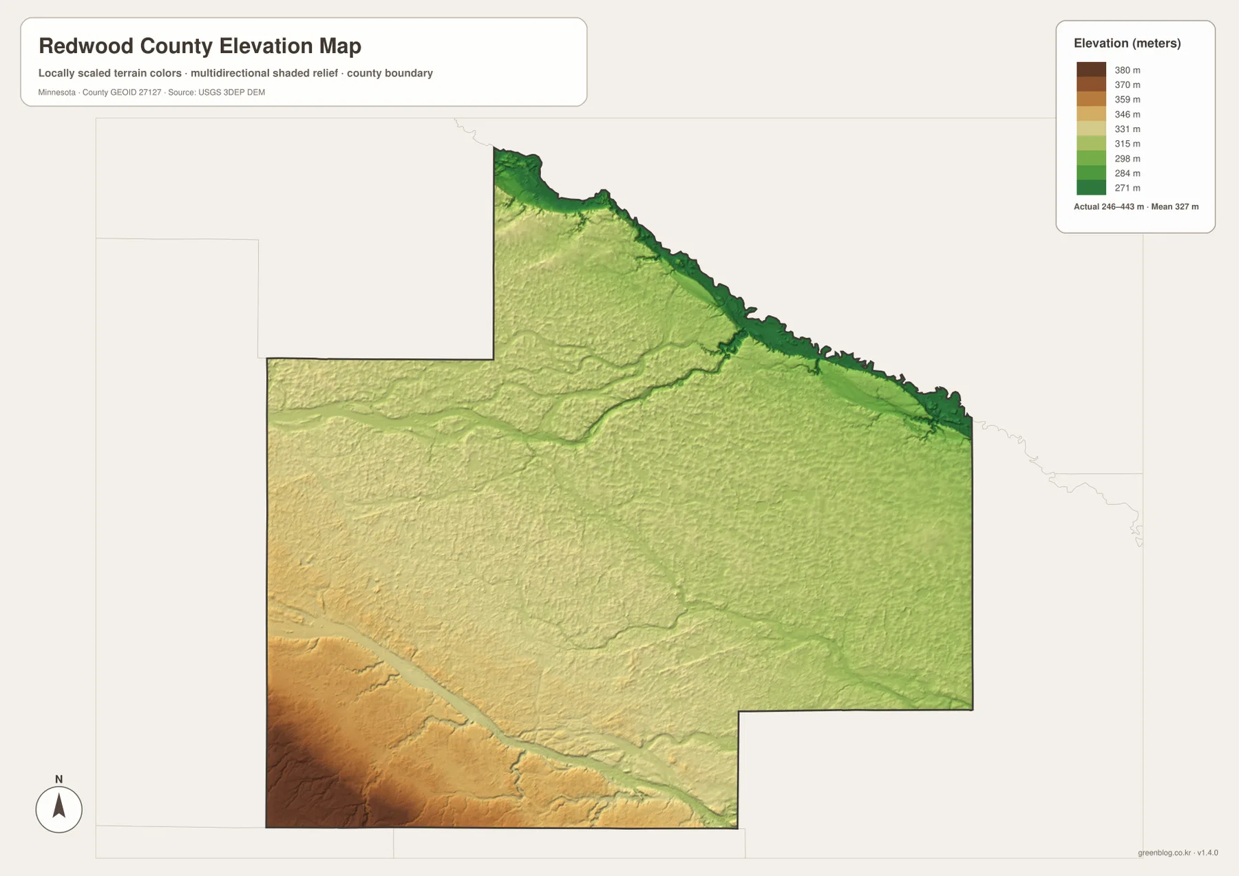
The colors are best read as a county-scale comparison. The displayed high and low values do not provide the surveyed elevation of an individual road, field, bridge, building, or property corner. Exact engineering, parcel, or construction work requires more detailed elevation or survey data. For regional orientation, however, the map clearly explains why the Minnesota River edge looks lower than the southwest and why the Redwood and Cottonwood river courses appear as lower paths through surrounding land.
Use Redwood Falls and Walnut Grove as anchors when switching between maps
Redwood Falls is the easiest place to follow through all four images. On the general map it is the road center where Highway 19 and U.S. 71 meet. On the ranked city map it carries the largest displayed value. The terrain-and-water view places it near Lake Redwood, the Redwood River, and the Minnesota River valley, while the elevation colors show that the same northeastern area is lower than much of the county to the southwest. Each map answers a different question without changing the underlying location.
Walnut Grove and Lamberton provide a useful southern comparison. Both are associated with the U.S. 14 corridor, but the Cottonwood River lies farther south, and the elevation map shows warmer colors than those along the northeastern Minnesota River valley. Wabasso and Morgan add a west-to-east comparison across the middle of the county: Wabasso is near Highway 68, while Morgan lies farther east near Highway 67. Following these familiar places from one image to the next makes the differences between roads, settlements, water, and terrain easier to understand.
Choose the general county map when you need the boundary, smaller place names, and major highways together. The city map is better for a clean comparison of the six selected centers. Use the terrain-and-water map for rivers, lakes, and smaller channels, and use the elevation map to compare the higher southwest with the lower river valleys. None of these maps is intended to replace parcel records, flood products, engineering surveys, or live transportation information.
Frequently Asked Questions
Which map is best for seeing Redwood Falls, its roads, and nearby rivers?
Begin with the general map to locate Highway 19, U.S. 71, and Redwood Falls. Then use the terrain-and-water map to add the Redwood River, Lake Redwood, and the Minnesota River valley. The elevation map adds another layer by showing that the northeastern river area is lower than much of the county to the southwest.
Are values such as 5,068 and 925 on the city map distances?
No. They are the displayed values used for the ranked city index and are not straight-line distances, driving distances, travel times, or municipal areas. Actual travel between cities depends on the road network and current conditions, so mileage should be checked with up-to-date navigation or transportation information.
Where are the higher and lower parts of Redwood County?
The southwest contains the highest terrain shown on the map, while the lowest area follows the Minnesota River along the northeastern boundary. Lower corridors are also visible along the Redwood River toward Redwood Falls and along the Cottonwood River in the south, making the river positions easier to understand when compared with the elevation colors.
Map File Information
The ZIP contains the original high-resolution JPG versions of the Redwood County maps shown on this page. The four files are suitable for larger displays, printed references, classroom use, or offline comparison.
- Included Files: Use only the versions confirmed in the article and supplied images
- File Type: Use the confirmed download contents
- Intended Use: Printing, education, presentations, and map-based projects
Related Maps
Sources and References
The article is based on the supplied Redwood County maps and official geographic references. For more detailed boundaries, waterways, elevation data, or current county information, consult the latest material from the sources below.
- Redwood County official website — county government and local information
- U.S. Census Bureau TIGER/Line Shapefiles — official geographic boundary and related data
- USGS National Hydrography — national river, stream, and waterbody information
- USGS 3D Elevation Program — official U.S. elevation data and 3DEP information
Green Map creates custom-edited map images using open geographic data sources such as geoBoundaries, Natural Earth, OpenStreetMap, and government open data. These maps are edited visual materials, not raw data files, and are provided for education, documents, presentations, and graphic reference.