Caddo Parish occupies Louisiana’s northwest corner, with Shreveport dominating the southern urban area and smaller communities such as Blanchard, Greenwood, Vivian, Oil City, and Mooringsport spread across the north and west. This Caddo Parish Map collection shows US 71, US 80, US 171, LA 1, LA 2, Caddo Lake, Black Bayou Lake, and the winding Red River edge that separates much of the parish from Bossier Parish. High-resolution map files are available for download in the section below.
The package includes three map themes only: a general parish map, a city-distribution map, and a terrain-and-water map. High-resolution JPG versions of all three can be downloaded together in one ZIP. Shreveport works as the southern anchor, while Vivian, Oil City, and Mooringsport help organize the lake-and-bayou landscape farther northwest.
Table of Contents
Shreveport’s dense road network gives way to a much more rural north
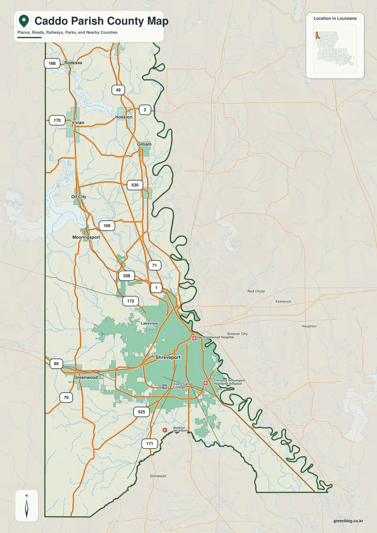
The general map is densest around Shreveport. US 80 enters from the Greenwood side, US 171 continues south, and LA 1, LA 173, and LA 525 provide additional references around the city. Hospital and college labels are concentrated in the same area, making the southern end of the parish visually very different from the rural north.
North of Shreveport, Blanchard provides the first clear settlement reference, while US 71 and LA 1 continue toward the upper parish. Mooringsport lies farther west, with Oil City to the north. LA 169, LA 530, and LA 538 help organize that area, where road spacing widens and streams and low-water features become more prominent.
Vivian is one of the clearest northwestern communities. LA 170 and the US 71 corridor provide convenient orientation, while Hosston, Gilliam, and Rodessa continue toward the northern end. Rodessa lies close to the Louisiana state-line corner and LA 168, making it a useful reference for the top of the parish.
The eastern boundary is not a straight survey line. It follows the winding Red River side opposite Bossier Parish, and Shreveport itself extends along that river corridor. The map is designed for geographic orientation rather than live navigation, traffic conditions, construction, speed limits, or private access.
Six city markers show the contrast between Shreveport and the northwestern towns
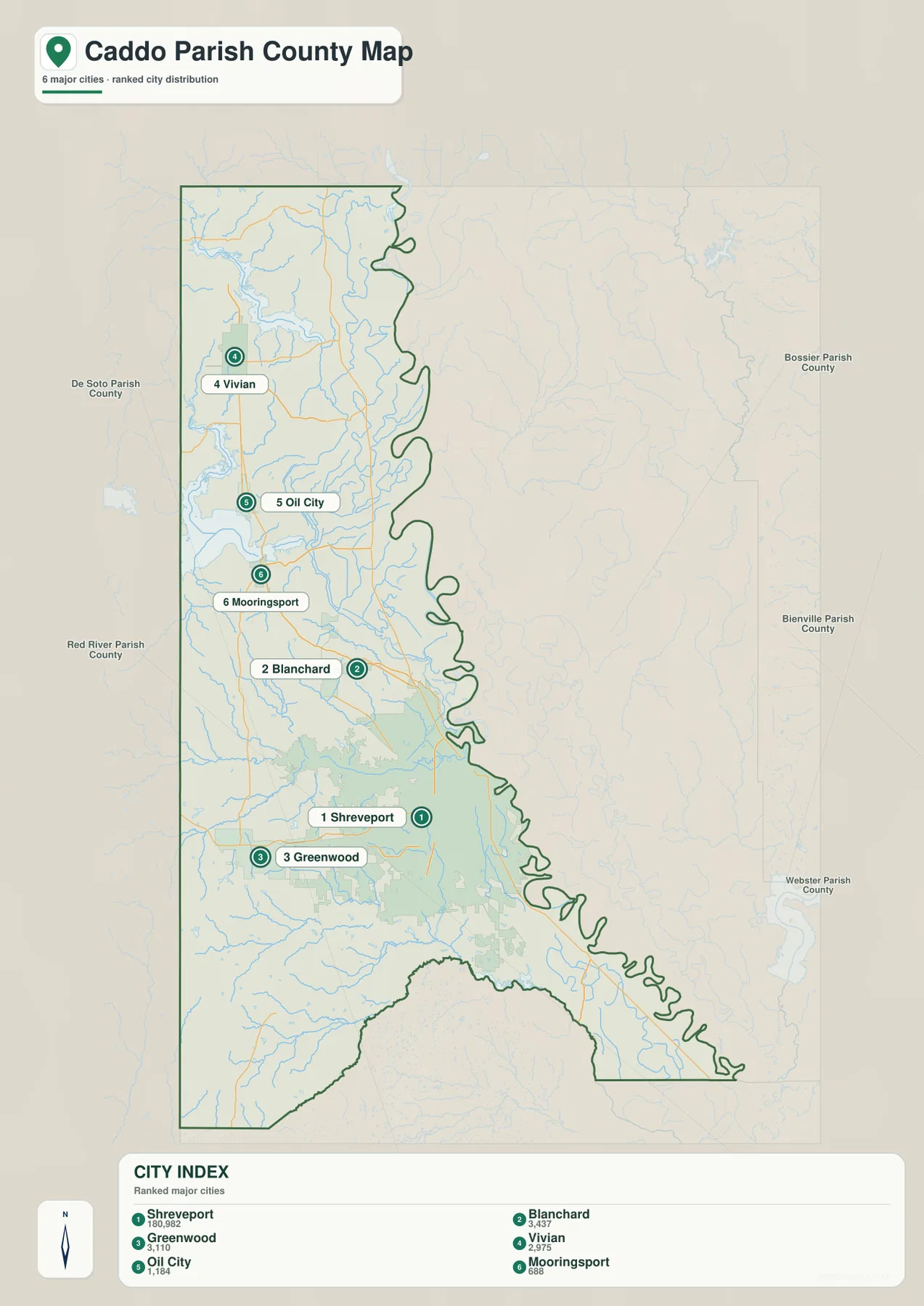
The city-distribution map makes the size contrast immediately obvious. Shreveport is the dominant city reference, while Blanchard and Greenwood sit nearby on the edge of the larger urban area. Vivian, Oil City, and Mooringsport are much farther northwest, creating a broad separation between the metropolitan south and the smaller communities around Caddo Lake.
Louisiana’s official Caddo Parish profile identifies Shreveport as the parish seat and city. It lists Blanchard, Greenwood, Oil City, and Vivian as towns, while Gilliam, Hosston, Mooringsport, Rodessa, and several other places are villages. The Parish of Caddo administration is also based in Shreveport, matching the city’s dominant role on the map.
Bossier Parish lies east across much of the Red River boundary, with Webster and Bienville Parishes farther east and southeast. Red River and De Soto Parishes are south and southwest. The western side reaches the Texas boundary, and the north approaches Arkansas, placing Caddo Parish at the extreme northwest corner of Louisiana.
The population figures printed in the city index belong to the source snapshot used to create the map and should not be treated as current official totals. Recent population comparisons should use the U.S. Census Bureau. The value of this map is the relative placement of the six settlement references, not the age-sensitive numbers beside them.
Caddo Lake and Black Bayou Lake dominate the northwestern water landscape
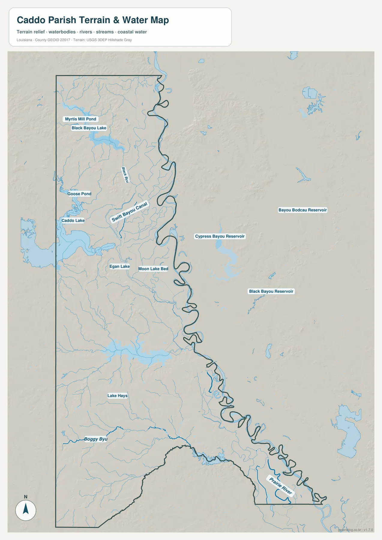
Caddo Lake is the strongest water feature in the northwest. It spreads along the Louisiana–Texas side near Mooringsport and Oil City, with Goose Pond and many smaller channels nearby. Black Bayou Lake and Myrtis Mill Pond sit farther north, while Black Bayou extends south through the same broad wetland area.
Swift Bayou Canal lies east of Black Bayou, and Egan Lake and Moon Lake Bed provide additional references in the central-northern interior. These features help explain why the road network between Oil City, Mooringsport, and Vivian is less regular than the streets around Shreveport. In this part of the parish, water is often the better orientation tool.
Lake Hays appears closer to the Shreveport side, while Boggy Bayou runs through the southwestern interior. The eastern boundary follows the Red River corridor toward Bossier Parish, producing a long series of bends rather than a straight line. Small channels and low areas near that boundary give the southeastern edge an especially irregular shape.
Cypress Bayou Reservoir and Black Bayou Reservoir appear east of the parish boundary on the map and should be treated as Bossier Parish references rather than Caddo Parish water bodies. The terrain-and-water file is also not a flood-insurance map, depth chart, navigation product, legal shoreline record, or parcel survey. Current flood, boating, and property questions require specialized agency data.
Shreveport, Caddo Lake, and the Red River edge show three different parish settings
Shreveport is the parish’s strongest road and civic center. US 80, US 171, LA 1, LA 173, and LA 525 cluster around the city, and both Louisiana’s official parish profile and the Parish of Caddo place the parish government in Shreveport. Roads and urban features are the easiest way to orient yourself in the south.
The Oil City–Mooringsport–Vivian side works differently. Caddo Lake, Black Bayou Lake, Black Bayou, and Swift Bayou Canal become more important than dense streets. Communities are farther apart, and the water map is often more useful than the road map for understanding why routes bend and where the lowland areas lie.
The eastern edge offers a third setting. The Red River controls the boundary opposite Bossier Parish, with Shreveport extending along the same river corridor farther south. Comparing these three areas—the urban south, the lake-rich northwest, and the winding eastern river boundary—makes the overall geography of Caddo Parish much easier to understand.
Choose the Caddo Parish file by the detail you need
The general map is the best starting point for communities, numbered roads, and the parish outline. The city map is cleaner when the six major settlement references are the main concern. The terrain-and-water map is the strongest choice for Caddo Lake, Black Bayou Lake, Black Bayou, Swift Bayou Canal, and the smaller lakes and bayous farther south.
- General map: Use it for Shreveport, Greenwood, Blanchard, Vivian, Oil City, Mooringsport, Hosston, Gilliam, Rodessa, US 71, US 80, US 171, LA 1, LA 2, LA 49, LA 168, LA 169, LA 170, LA 173, LA 525, LA 530, and LA 538.
- City map: Use it to compare Shreveport, Blanchard, Greenwood, Vivian, Oil City, and Mooringsport and to see the directions of Bossier, Bienville, Webster, Red River, and De Soto Parishes.
- Terrain and water map: Use it for Caddo Lake, Black Bayou Lake, Myrtis Mill Pond, Goose Pond, Black Bayou, Swift Bayou Canal, Egan Lake, Moon Lake Bed, Lake Hays, and Boggy Bayou.
Each original JPG measures 2572 × 3638 pixels in portrait orientation, preserving more small road and waterway labels than the web previews. Keeping the original aspect ratio is recommended for printing. When using all three files, start with Shreveport and Vivian, then compare the Caddo Lake side with the Red River boundary.
Frequently Asked Questions
Which map is best for Shreveport, Vivian, and US 71?
The general parish map is the best choice because it combines Shreveport, Blanchard, Greenwood, Vivian, Oil City, Mooringsport, US 71, US 80, US 171, LA 1, LA 169, LA 170, and LA 173 in one view.
Where can I see Caddo Lake and Black Bayou Lake most clearly?
The terrain-and-water map shows Caddo Lake, Black Bayou Lake, Myrtis Mill Pond, Goose Pond, Black Bayou, Swift Bayou Canal, Egan Lake, Moon Lake Bed, Lake Hays, and Boggy Bayou. It is a geographic reference rather than a flood, depth, navigation, or legal-boundary map.
Are the city-map population figures current?
No. The figures beside Shreveport, Blanchard, Greenwood, Vivian, Oil City, and Mooringsport belong to the source snapshot used for the map. Current population totals and rankings should be checked with the U.S. Census Bureau.
Map File Information
The ZIP contains high-resolution JPG versions of the Caddo Parish general map, city-distribution map, and terrain-and-water map. Use the previews to check Shreveport, Vivian, Blanchard, the main road network, Caddo Lake, Black Bayou Lake, and the Red River boundary before opening the original files.
- Included Files: Use only the versions confirmed in the article and supplied images
- File Type: Use the confirmed download contents
- Intended Use: Printing, education, presentations, and map-based projects
Related Maps
Sources and references
The geographic discussion is based primarily on the supplied Caddo Parish maps, with official parish and Shreveport pages plus federal boundary and hydrography sources used for context.
- Parish of Caddo – Administration — official parish government, location, and administrative information.
- Louisiana.gov – Caddo Parish — official parish profile, parish seat, and municipality list.
- City of Shreveport official website — official city information and services.
- U.S. Census Bureau TIGER/Line Shapefiles — official geographic boundary and road data.
- USGS National Hydrography — federal hydrography background for lakes, rivers, bayous, and waterways.
Green Map creates custom-edited map images using open geographic data sources such as geoBoundaries, Natural Earth, OpenStreetMap, and government open data. These maps are edited visual materials, not raw data files, and are provided for education, documents, presentations, and graphic reference.