Ogemaw County occupies a quiet part of northeastern Michigan’s Lower Peninsula where settlement, roads, lakes, and wooded uplands are spread over a broad area rather than packed into one continuous urban corridor. West Branch is the easiest place to orient yourself because I-75/US-23 and M-55 meet nearby, but the county quickly changes character as the map moves toward Rose City, Lupton, Prescott, and the many small lakes farther east. The A3 JPG maps used in this article are also available together as a single ZIP download for readers who want full-size files.
The county makes more sense when its roads are read together with water and elevation. Major travel is concentrated around West Branch, while the Rifle River system and lake country become more prominent toward the central and eastern side. The north and northwest rise into noticeably higher ground, whereas much of the east and southeast sits lower. Those contrasts explain why a road map, a city-connection map, a water map, and an elevation map each reveal a different part of the same county story.
Table of Contents
West Branch provides the clearest starting point for reading the county road pattern
West Branch lies toward the southwestern side of Ogemaw County rather than at its geometric center. I-75/US-23 passes the city and carries the strongest long-distance north-south movement visible on the map. M-55 crosses the county from west to east and meets that highway corridor near West Branch, creating the most obvious junction in the county. Once that crossing is located, the rest of the road network becomes easier to place because M-33 and other routes can be read in relation to it rather than as isolated lines.
The settlement pattern is loose. Rose City appears north of West Branch, Lupton lies farther to the east, and Prescott sits close to the southeastern side. Skidway Lake forms another recognizable place near the southern part of the county. Large spaces remain between those names, and those spaces are filled by local roads, woods, streams, and lakes rather than dense suburban development. That is why Ogemaw County is easier to understand through a combination of roads and landscape than through city labels alone.
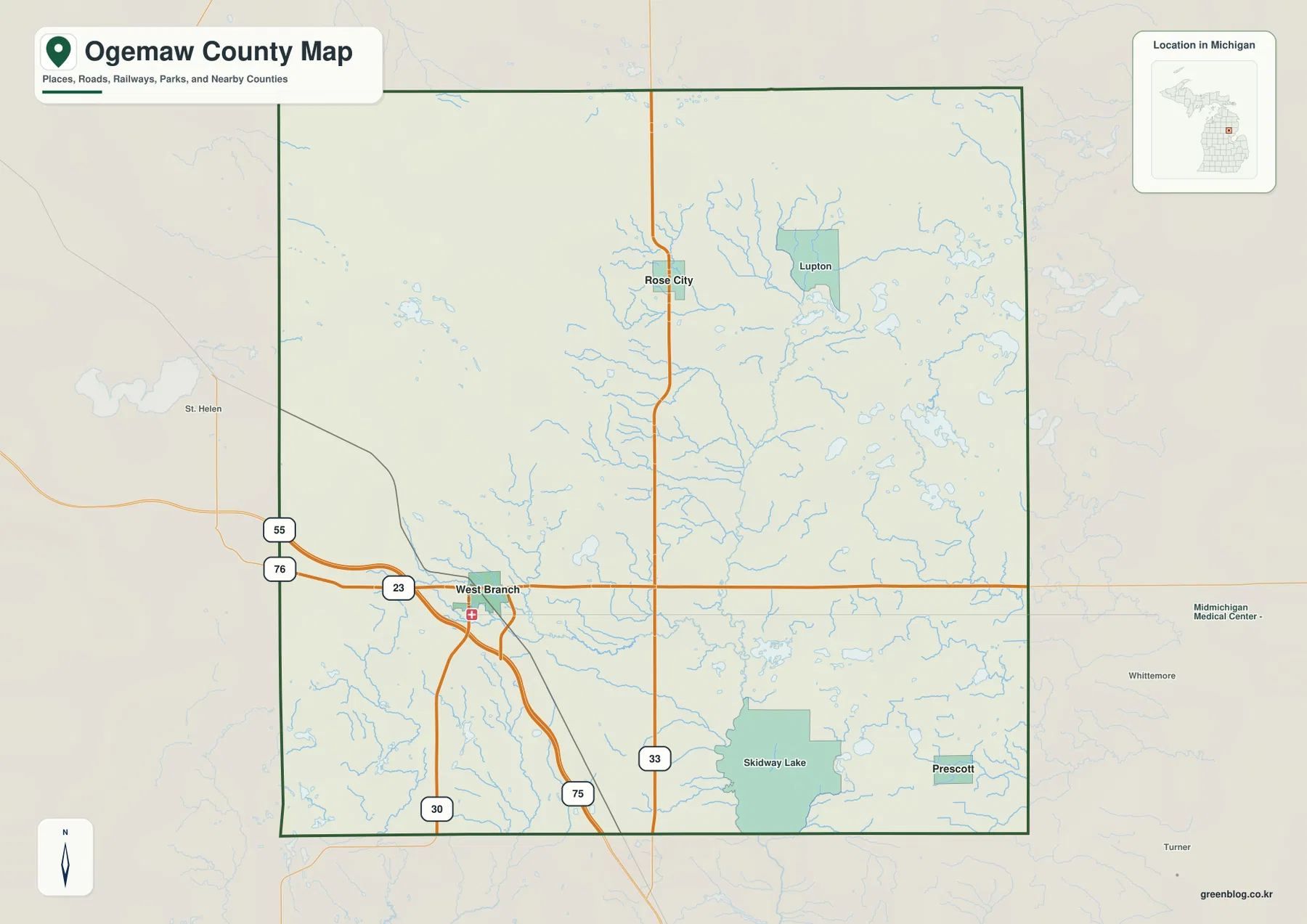
The surrounding county names also give useful context. Roads leaving Ogemaw County connect toward Roscommon County on the west and Iosco County on the east, while other neighboring counties frame the northern and southern edges. Those labels help explain where the county sits within the Lower Peninsula, but they should not be used as a substitute for parcel or legal-boundary records. Property lines, jurisdiction questions, and survey work require the appropriate local or state source.
Rose City and Prescott show the wide spacing between the county’s main communities
The city-connection map strips away most of the detail and compares three places directly. West Branch is the reference point, with Rose City shown about 12 miles to the north and Prescott about 16 miles to the southeast. The labels represent straight-line distances between the mapped points, not the mileage a driver would record on the road. Real travel is longer because vehicles follow the road network, turns, and local routing rather than the direct connector drawn on the map.
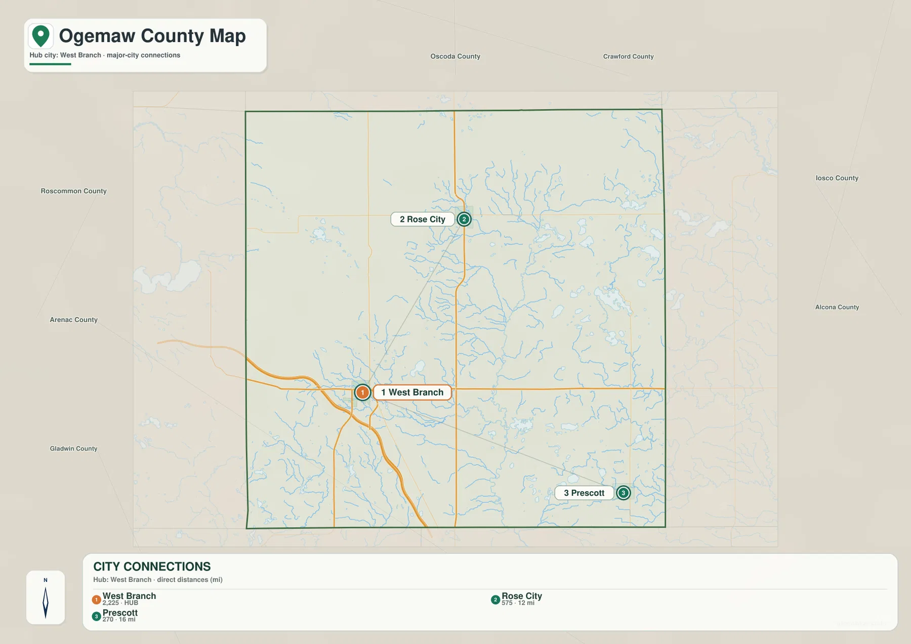
That simple geometry says a great deal about the county. West Branch functions as the stronger transportation center, Rose City is tied to the northern part of the county, and Prescott marks a southeastern focus. When Lupton and Skidway Lake are added back from the general map, the county reads as a collection of separated communities rather than a single built-up cluster. The city map is therefore best for quick spatial comparison, while the general map is better when the actual highways and local connections matter.
Rifle River country is a network of streams and lakes rather than one isolated waterway
The water map is anchored by the Rifle River system. The main river crosses the central part of the county, and the West Branch Rifle River extends the pattern toward the south. Houghton Creek enters the picture in the north, while the Au Gres River and Silver River help define drainage on the southeastern side. Smaller tributaries join those larger channels from several directions, giving the county a branching water pattern that is much easier to see on the hydrology-focused map than on the general county map.
The lakes reinforce that impression. Lake Ogemaw is an important reference in the south-central area, while Sage Lake and George Lake help identify the eastern lake country. Clear Lake and Rifle Lake add water features on the western and southwestern side. Instead of forming one large lake district with a sharp boundary, these waters are woven through the county among roads, woods, and rolling ground. Reading them as part of the river network avoids turning the map into a list of unrelated lake names.
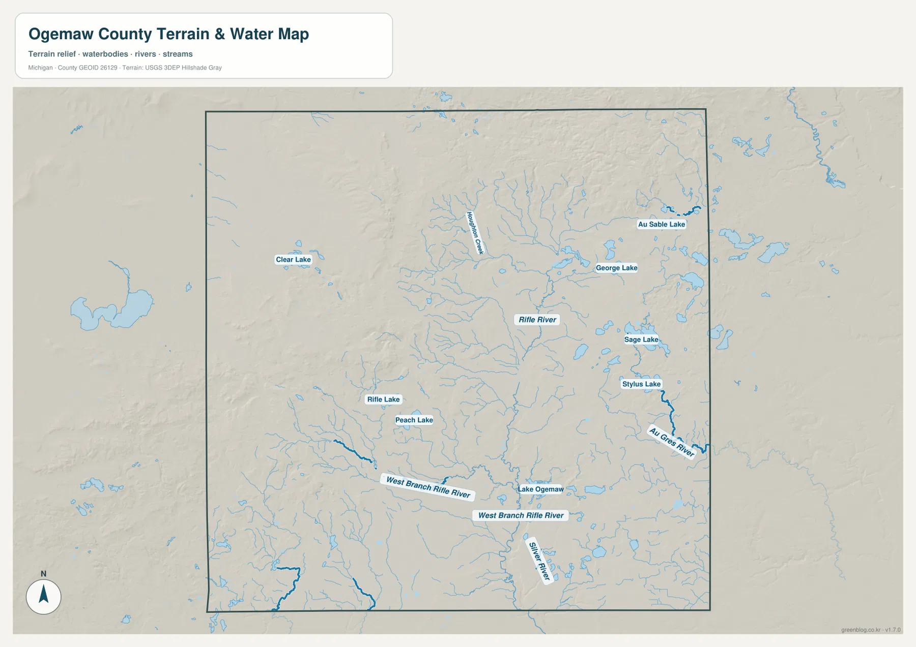
This map is intended for geographic reference, not for flood prediction or navigation. A blue line does not by itself describe channel depth, seasonal flow, or boating conditions, and the map does not replace current rules for fishing, launches, or protected areas. It is most useful for understanding where named waters sit relative to towns and higher ground before consulting more specialized information for a specific outdoor activity or safety decision.
Northern uplands create a strong contrast with the lower east and southeast
Elevation changes are one of the most distinctive features in the set. The northwestern and northern parts of Ogemaw County appear in the higher brown and yellow classes, where rolling uplands occupy a broad area. Colors become lower toward the central and eastern sections, and much of the east and southeast is shown in greener tones. The transition is not a single ridge or cliff; it is a county-wide shift from higher rolling terrain into lower country toward the eastern side.
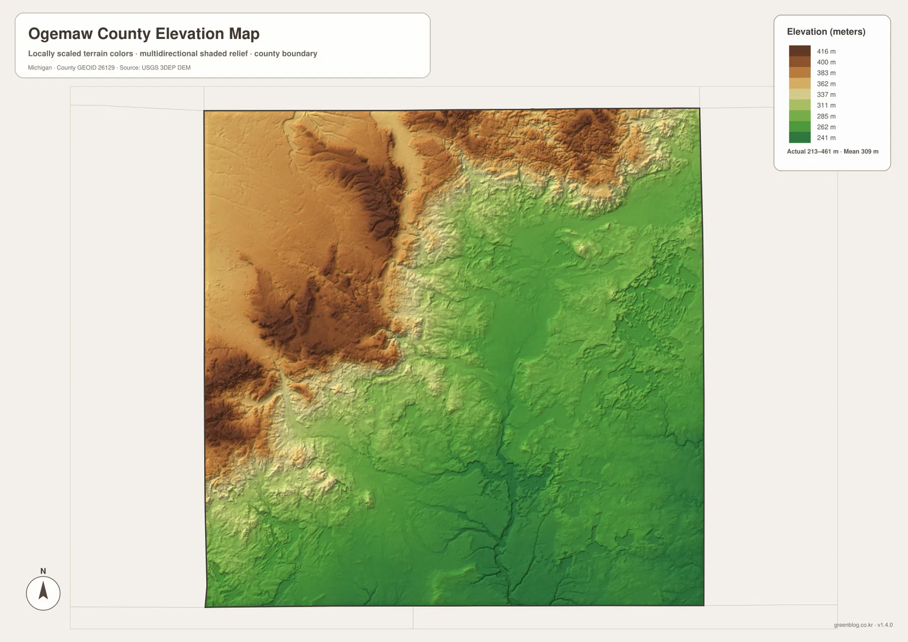
The map reports an actual county elevation range of roughly 213 to 461 meters with a mean near 309 meters. Those values are suitable for comparing broad areas, not for assigning an exact elevation to a house, road shoulder, or building site. When the elevation map is compared with the water map, the river network becomes easier to interpret because many tributaries follow the general movement from higher ground toward lower terrain. That comparison adds geographic context without turning the map into a survey product.
Low elevation should also not be treated as a direct synonym for flood risk. Flooding depends on river stage, drainage, soils, infrastructure, and official floodplain boundaries in addition to elevation. The shaded surface is best used for regional orientation, recreation planning, and explaining why the northern part of the county feels more rolling than the lower eastern side.
Roads and landscape divide the county into noticeably different local settings
West Branch feels different from the communities farther north and east because the transportation network is more concentrated there. The I-75/US-23 and M-55 junction gives the city a regional access role that Rose City, Lupton, and Prescott do not share in the same way. North of West Branch, rising terrain and wooded land become more important. Eastward, streams and lakes appear more frequently. Near the southeast, the lower surface and dispersed settlements create another setting again. These are gradual changes, but the four maps make them easy to compare.
Local recreation reflects the same geography. Visitor information for the West Branch area highlights places such as Rifle River Recreation Area and Ogemaw Hills Pathway. The first connects naturally with the river-and-lake pattern on the water map, while the second makes sense in the context of the higher northern terrain. The maps do not provide trail conditions or seasonal operating details, so anyone planning a visit should still check current local information before leaving.
Choose the map that matches the question before adding more detail
For general orientation, the county map is the best first choice because it keeps the main settlements, highways, water features, and boundary in one view. The city map is better when the task is simply to compare West Branch with Rose City and Prescott. The water map becomes the priority for Rifle River, Lake Ogemaw, tributaries, and lake locations, while the elevation map gives the clearest view of the higher north and lower southeast. Starting with the most relevant map makes the information easier to explain and reduces the temptation to force every detail into one image.
The download archive contains the full-resolution JPG versions of the county, city-connection, water, and elevation maps used above. Each file is prepared at 3638 × 2572 pixels in landscape A3 proportions. They work well as reference images for classroom material, presentations, trip notes, and personal printing, although small labels should always be checked at the intended print size. Legal boundaries, engineering design, emergency planning, and surveying require the authoritative source data rather than these general reference maps.
Frequently Asked Questions
Are the 12-mile and 16-mile labels from West Branch driving distances?
No. The city-connection map uses straight-line distances from West Branch to Rose City and Prescott. A driver follows the road network, so actual mileage and travel time will normally be greater and will depend on the selected route. Use the connector map to compare relative direction and spacing, then check a current routing service for a real trip.
Which map is best for following the Rifle River and Lake Ogemaw together?
The water map is the best choice because it places the Rifle River, West Branch Rifle River, Lake Ogemaw, tributaries, and several other lakes on the same terrain background. It is a geographic reference map rather than a flood, depth, navigation, or boating-regulation map, so specialized activities still require current information from the relevant agencies.
Where does the highest ground appear in Ogemaw County?
The elevation map shows the broadest high ground in the north and northwest. Terrain generally becomes lower toward the east and southeast. The mapped county range is about 213 to 461 meters, with an average near 309 meters. Those numbers describe the county-scale surface and should not be used as survey-grade elevations for an individual property or road.
Map File Information
Download the high-resolution JPG maps used on this Ogemaw County page together in one ZIP file.
- Included Files: county map, city-connection map, water map, elevation map
- File Type: ZIP containing 4 JPG files
Related Maps
Sources and References
- Ogemaw County official website — county government and official local information
- West Branch Visitors Bureau local attractions — Rifle River Recreation Area, Ogemaw Hills Pathway, and local outdoor information
- Library of Michigan Ogemaw County Guide — county history and research references
- U.S. Census Bureau TIGER/Line Shapefiles — county boundary and geographic data
- USGS National Hydrography — rivers, streams, lakes, and hydrographic data
- USGS 3D Elevation Program — elevation data
Green Map creates custom-edited map images using open geographic data sources such as geoBoundaries, Natural Earth, OpenStreetMap, and government open data. These maps are edited visual materials, not raw data files, and are provided for education, documents, presentations, and graphic reference.