Ontonagon County occupies a broad piece of Michigan’s western Upper Peninsula where the Lake Superior shoreline, the Porcupine Mountains, long forested interiors, and the branching Ontonagon River system all meet. The village of Ontonagon sits on the northern shore near the river mouth, while White Pine lies to the west and Ewen and Bruce Crossing anchor the southern interior. This page explains the places, roads, rivers, lakes, and elevation patterns visible on the supplied maps, and the same A3 high-resolution JPG map files can be downloaded together in one ZIP archive.
The county is especially useful for comparing coast, mountain, and river-valley geography in one view. Low terrain follows Lake Superior and the main river valleys, while much higher ground rises in the western Porcupine Mountains and across parts of the southern interior. On the road map, M-38, M-26, M-28, and US-45 provide simple reference lines for locating Ontonagon, Greenland, Rockland, Ewen, and Bruce Crossing. The city-index graphic is intentionally much simpler and highlights only Ontonagon, so it should be read together with the full county map rather than as a complete list of communities.
Table of Contents
Start with the Lake Superior shore at Ontonagon, then follow the main routes south
The full county map gives Ontonagon the clearest northern reference point. The village sits along Lake Superior close to the mouth of the Ontonagon River, and it is also the county seat. M-38 runs inland from the Ontonagon area toward the east, while M-26 appears around Rockland and Greenland farther inland. In the southern part of the county, Bruce Crossing is easy to recognize because US-45 and M-28 meet there, creating a useful road reference between the Lake Superior shore and the deeper interior of the Upper Peninsula.
White Pine is shown west of Ontonagon, closer to the rugged terrain that leads toward the Porcupine Mountains. Ewen appears in the south-central area not far from Bruce Crossing, and the county boundary bends around several large blocks rather than forming a simple rectangle. Neighboring areas in Gogebic, Houghton, Iron, and Baraga counties appear outside the dark county outline, which helps place Ontonagon County within the broader western Upper Peninsula without confusing nearby communities with places inside the boundary.
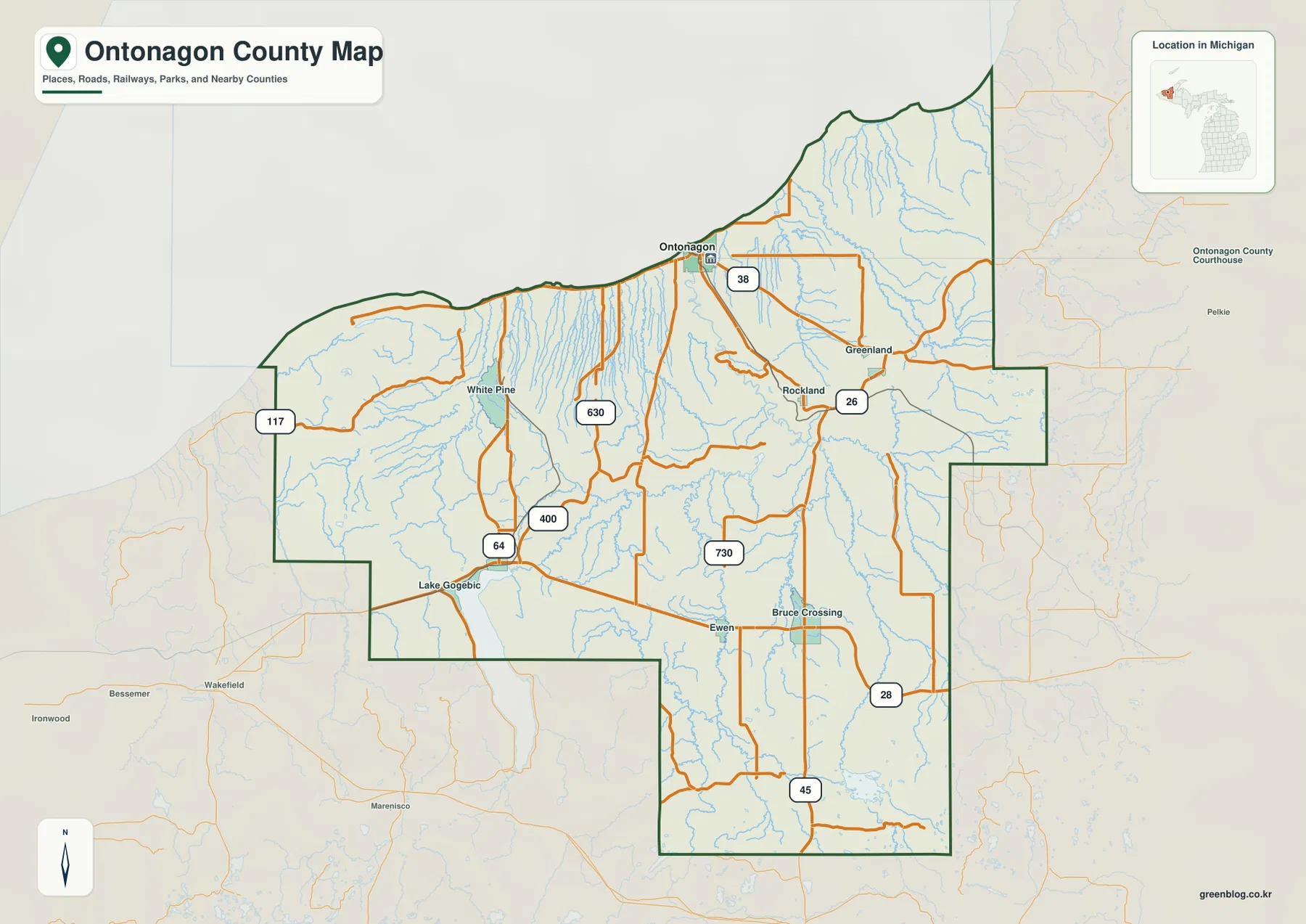
The road pattern reflects the county’s large size and rugged terrain. M-38 is the clearest eastward route from Ontonagon, M-26 links communities around Rockland and Greenland, M-28 crosses the southern interior, and US-45 provides a strong north-south reference through Bruce Crossing. Western local roads have to work around mountains, river valleys, and the Lake Gogebic area, so the network is less regular than a grid. The map is useful for orientation, but it does not show live construction, winter closures, or current driving conditions.
The county outline is also important because water and terrain continue beyond it. Lake Gogebic extends southward into neighboring territory, and roads near the western and southern edges connect with communities outside Ontonagon County. For legal property boundaries, road jurisdiction, or parcel research, the general map should not replace official records. Ontonagon County maintains a GIS resource for land information, and its own notice explains that such mapping is a general guide rather than a land survey.
The city index isolates Ontonagon instead of drawing a network of city-to-city distances
The city-index map contains one ranked place: Ontonagon. Unlike county graphics that connect several major cities with straight lines, this map has no connector lines and no straight-line distance labels. Its purpose is to make the principal settlement easy to locate on a simplified background. White Pine, Greenland, Rockland, Ewen, and Bruce Crossing still appear on the full county map, so the single-place index should not be interpreted as evidence that those communities are absent from the county.
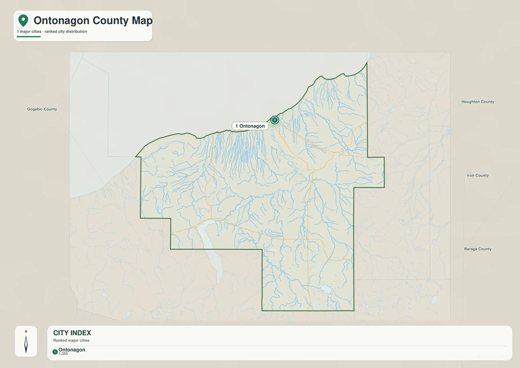
Ontonagon County’s official website identifies Ontonagon as a village, and the county courthouse is located there. On the broader map, its setting near Lake Superior, the Ontonagon River, and the start of M-38 makes it a natural place from which to describe the rest of the county. White Pine lies west toward the Porcupine Mountains, Rockland and Greenland lie inland to the east, and Bruce Crossing provides a second strong reference much farther south at the US-45 and M-28 junction.
The simplified index works well when a presentation or worksheet needs one unmistakable anchor without the visual weight of minor roads and streams. It is less useful for explaining travel between communities because no route or distance information is encoded in it. For that purpose, the county map is the better choice. Using the two together keeps the settlement pattern clear: one graphic emphasizes the main village, while the other preserves the wider set of communities and roads.
The Ontonagon River branches across the interior while mountain streams cut toward Lake Superior
The terrain-and-water map is dominated by the Ontonagon River system. The West Branch Ontonagon River approaches from the west, while the South Branch and Middle Branch Ontonagon River rise through the southern interior and feed the larger drainage. Victoria Reservoir is marked near this river network, adding a broad water feature among the long branching channels. Farther north, the main Ontonagon River continues toward Lake Superior, where the low river corridor reaches the coast near the village.
The western side has a different pattern. Big Iron River and Presque Isle River descend through the rough ground around the Porcupine Mountains, and Lake of the Clouds occupies a high inland basin near the western uplands. The map also shows the northern part of Lake Gogebic and Bingham Bay near the southwest, while Flintsteel River reaches the Lake Superior side farther east. These features make clear that the county is not organized around only one river; several separate watersheds cross the mountains and forest before reaching larger lakes or river systems.
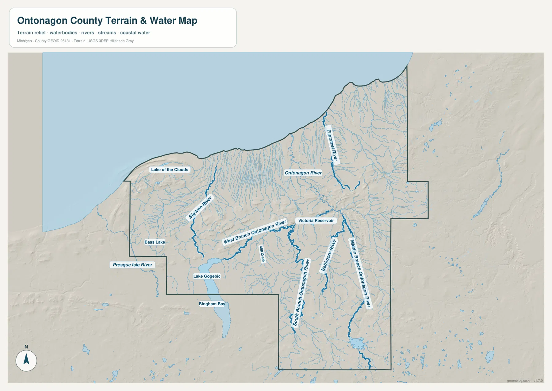
Comparing this map with the elevation layer helps explain why the channels look so different. The western mountains and southern uplands feed narrow valleys, while the central Ontonagon River branches occupy lower corridors that cut through the interior. Along Lake Superior, many streams complete a relatively short descent from higher ground to the shoreline. The relationship is especially visible around the Porcupine Mountains, where the steep terrain stands close to the lake and the watercourses follow pronounced valleys.
This is a geographic reference map rather than a flood, depth, navigation, or access map. Blue lines should not be read as exact channel widths, and the graphic does not show seasonal flow, ice safety, private access rules, or current water conditions. Anyone planning fishing, paddling, waterfall visits, or winter travel should check current information from Michigan DNR and local agencies. For regional explanation, however, the map is effective at showing which rivers belong to the Ontonagon system and which western streams descend independently through the mountains.
Elevation rises sharply from the Lake Superior coast into the Porcupine Mountains
The elevation map shows one of the strongest terrain contrasts in the Michigan county series. Green shades follow much of the Lake Superior shore and the major river valleys, while dark browns mark much higher ground in the western Porcupine Mountains. The color change happens quickly near the western shoreline, making the mountain front easy to recognize. Lower green corridors also branch inland along the Ontonagon River and its tributaries, cutting through higher yellow and brown surfaces.
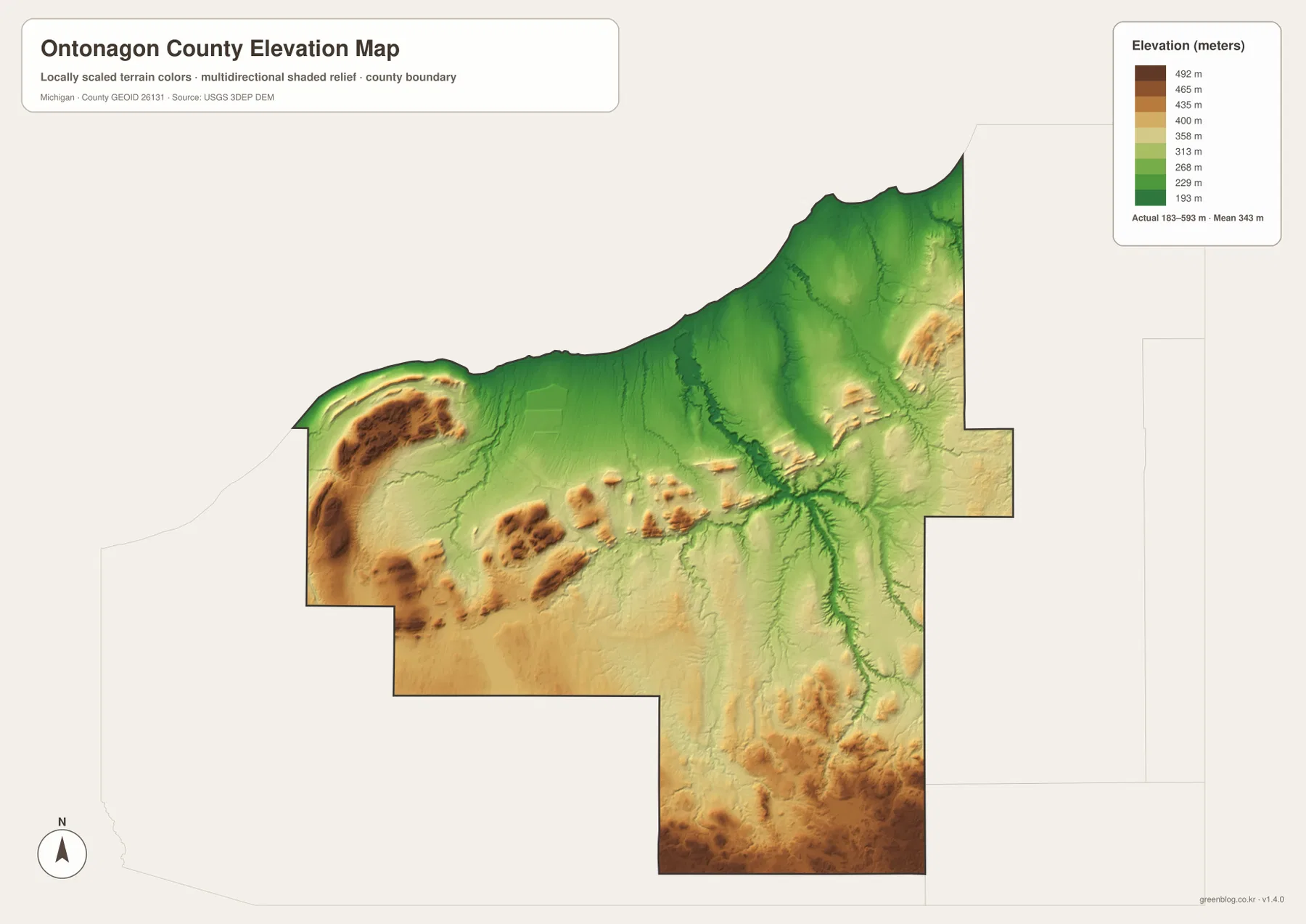
The legend uses representative color bands from about 193 to 492 meters, while the map separately reports an actual surface range of roughly 183 to 593 meters and a mean near 343 meters. Those numbers are most useful as county-scale context, not as survey elevations for a particular address. Brown patches also appear in the southern interior, showing that the county’s higher terrain is not confined to the Porcupine Mountains. The central river valleys remain lower and form a branching green pattern through the surrounding uplands.
Michigan DNR describes the Porcupine Mountains as rising abruptly from Lake Superior, with a long escarpment and Lake of the Clouds on the inland side. That description matches the sharp color transition visible in the western part of the elevation map. At the same time, the county contains extensive lower land around Ontonagon, the river corridors, and the lakeshore, so it should not be described as uniformly mountainous. The value of the elevation map is the contrast between these landscapes rather than any single high point.
The generalized elevation surface is appropriate for regional orientation, classroom work, and explanations of terrain. It should not be used for engineering design, drainage calculations, flood determinations, road-grade measurement, or legal surveying. Those tasks require original USGS elevation data, detailed contours, and often field measurements. For ordinary map reading, the layer clearly shows why the western landscape feels much more rugged than the low Lake Superior shore and the broad river valleys farther east.
Porcupine Mountains and Lake of the Clouds give the western county a distinct geographic identity
Porcupine Mountains Wilderness State Park occupies a large part of the western landscape and extends into neighboring Gogebic County. Michigan DNR describes the area as a major wilderness of old-growth forest, rivers, waterfalls, long hiking routes, and Lake Superior views. On the supplied maps, its geography is recognizable even without a park boundary overlay: the high western relief, Lake of the Clouds, Presque Isle River, Big Iron River, and the nearby Lake Superior shore form a tightly connected group of features unlike the broader river valleys farther east.
Looking east from the mountains, the terrain drops toward White Pine and the Lake Superior shore, then opens into the Ontonagon River drainage. Looking south, the map approaches Lake Gogebic before rising again across the interior. This sequence explains why a simple road map does not fully describe the county. Roads, lakes, valleys, and high ground influence one another, and a route that appears short on a small overview may cross very different terrain once it leaves the shore or a river valley.
Seasonal conditions matter in this part of the Upper Peninsula. Michigan DNR notes that some roads in Porcupine Mountains Wilderness State Park close to regular vehicles during winter and may function as snowmobile routes until conditions allow reopening. The maps on this page are therefore best treated as geographic references rather than live access guides. Before a hike, scenic drive, or winter trip, check the park’s current road, trail, and facility notices in addition to using the static map.
Choose the map that matches the question: roads, settlements, water, or relief
For a general overview, the county map carries the most information in one frame. It shows Ontonagon, White Pine, Greenland, Rockland, Ewen, Bruce Crossing, the county boundary, Lake Superior, and major routes such as M-38, M-26, M-28, and US-45. The city index is better when the only goal is to emphasize Ontonagon on an otherwise uncluttered county outline. Because it contains no distance connectors, it should not be used for travel-time or city-to-city distance comparisons.
The water map is the strongest choice for explaining the Ontonagon River branches, Lake of the Clouds, Victoria Reservoir, Big Iron River, Presque Isle River, and Lake Gogebic. The elevation map adds the missing vertical dimension by separating the low shore and valleys from the Porcupine Mountains and other high interior ground. In a report or lesson, pairing the water and elevation maps is especially useful because the river valleys line up clearly with lower terrain.
The downloadable ZIP contains the original JPG versions of the county map, city-index map, terrain-and-water map, and elevation map used in this article. Each image is supplied at 2572 × 3638 pixels for A3 portrait printing. They can support classroom material, regional overviews, presentations, or personal reference printing. If small stream names and road labels need to remain readable, check the print scaling before producing a reduced-size copy. Legal boundaries, emergency response, navigation, flood analysis, and engineering work require the appropriate official datasets instead.
Frequently Asked Questions
Which map is best for locating the Porcupine Mountains and Lake of the Clouds?
Use the county map first for the broad road-and-place context, then compare the water and elevation maps. Lake of the Clouds appears within the high western terrain of the Porcupine Mountains, near Big Iron River and Presque Isle River. The elevation layer makes the sharp rise above Lake Superior especially clear. For current park-road or trail access, use Michigan DNR’s latest park information because seasonal closures are not shown on these static maps.
Why does the city-index map show only Ontonagon?
The city index is a simplified ranking graphic and highlights only the principal settlement. It is not a complete community map. White Pine, Greenland, Rockland, Ewen, and Bruce Crossing are visible on the full county map. There are also no connector lines or straight-line distance values on this version, so the index should not be interpreted as a distance chart.
What is the clearest elevation pattern in Ontonagon County?
The Lake Superior shore and major river valleys are relatively low, while the western Porcupine Mountains and parts of the southern interior rise much higher. The elevation layer reports an overall surface range of roughly 183 to 593 meters. Those values are useful for county-scale comparison but not for parcel-level surveying, engineering, or flood determinations, which require more detailed official data.
Map File Information
Download the high-resolution JPG maps used on this page as one ZIP file for Ontonagon County.
- Included Files: county map, city map, water map, elevation map
- File Type: ZIP containing 4 JPG files
Related Maps
Sources and references
- Ontonagon County – Village of Ontonagon — official local information for the village and county-seat area
- Michigan DNR – Porcupine Mountains — official description of the mountains, Lake of the Clouds, forest, and escarpment
- Michigan DNR – Porcupine Mountains Wilderness State Park — current park location, road, and seasonal access information
- U.S. Census Bureau – TIGER/Line Shapefiles — county-boundary and base-geography reference
- U.S. Geological Survey – National Hydrography — river, stream, and lake reference data
- U.S. Geological Survey – 3D Elevation Program — elevation and terrain reference data
Green Map creates custom-edited map images using open geographic data sources such as geoBoundaries, Natural Earth, OpenStreetMap, and government open data. These maps are edited visual materials, not raw data files, and are provided for education, documents, presentations, and graphic reference.