Osceola County lies in the west-central part of Michigan’s Lower Peninsula, where Reed City and Evart form a recognizable southern corridor while Marion, Tustin, and Le Roy sit farther apart across the interior. US-10, US-131, M-66, and M-115 give the county a simple road framework, but the waterways and relief make the landscape more varied than the road map first suggests. This page explains the places, rivers, lakes, and elevation changes shown on the supplied maps, and the original A3-size JPG map files can be downloaded together in one ZIP archive.
The county contains several distinct drainage areas rather than one dominant river crossing every community. Pine River and East Branch Pine River stand out in the northwest, the Middle Branch River system occupies much of the east, and the Muskegon River appears across the southern interior. Rose Lake, Hicks Lake, Strawberry Lake, Big Lake, and other smaller water bodies break up the uplands between those channels. The elevation layer adds another useful contrast: high terrain is concentrated in the north-central and central parts of the county, while lower ground is more common along the eastern and southern river valleys.
Table of Contents
US-10 links Reed City and Evart across the southern part of the county
On the general county map, Reed City is the easiest western reference point. It sits close to the county’s southwest corner, where US-131 runs north-south and US-10 continues east across the lower part of Osceola County. Following US-10 leads toward Hersey and then Evart, creating the clearest chain of settlements on the map. East of Evart, the road reaches the M-66 corridor, which continues north toward Marion. Once those three major routes are located, the positions of Le Roy, Tustin, and the smaller local roads become much easier to understand.
Reed City, Hersey, and Evart are relatively close to one another compared with the communities farther north. Tustin and Le Roy occupy the western interior, while Marion sits near the northeastern side of the county. M-115 cuts diagonally through the northeast and approaches the M-66 corridor, giving that part of the map a different road pattern from the straighter US-10 route in the south. Labels outside the county boundary, including nearby communities such as McBain and Barryton, provide additional context without changing the focus of the map.
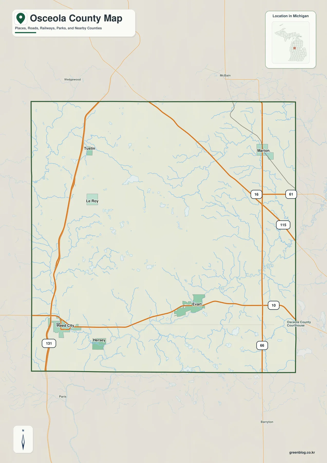
The road layout also explains why a county-wide view is more useful than a simple list of communities. Reed City has quick access to the north-south US-131 corridor, Evart is centered on the east-west US-10 route, and Marion is better oriented by M-66 and the diagonal M-115 corridor. The northern interior contains fewer large road labels and wider gaps between named places. The map is useful for geographic orientation, but it does not show live traffic, construction, winter closures, or every local road, so current transportation information should be checked separately before driving.
The county boundary is fairly regular, yet settlement is not evenly distributed inside it. The southern towns are arranged along a strong east-west route, while the western and northeastern communities are separated by larger rural spaces. That contrast becomes important when the city index is viewed beside the county map. One image emphasizes roads and boundaries; the other strips away much of that detail so the six ranked places are easier to compare. Neither should be treated as a parcel map or a legal boundary survey.
The city index spreads six named communities from Reed City to Marion and Tustin
The city-index map ranks six places and shows their distribution without drawing distance connectors between them. Reed City is marked first and Evart second, followed by Marion, Hersey, Tustin, and Le Roy. Because there are no connecting lines or mileage labels, this version is not a straight-line distance chart. Its strength is visual separation: Reed City and Hersey occupy the southwest, Evart lies farther east across the southern half, Marion is isolated in the northeast, and Tustin and Le Roy sit in the western interior.
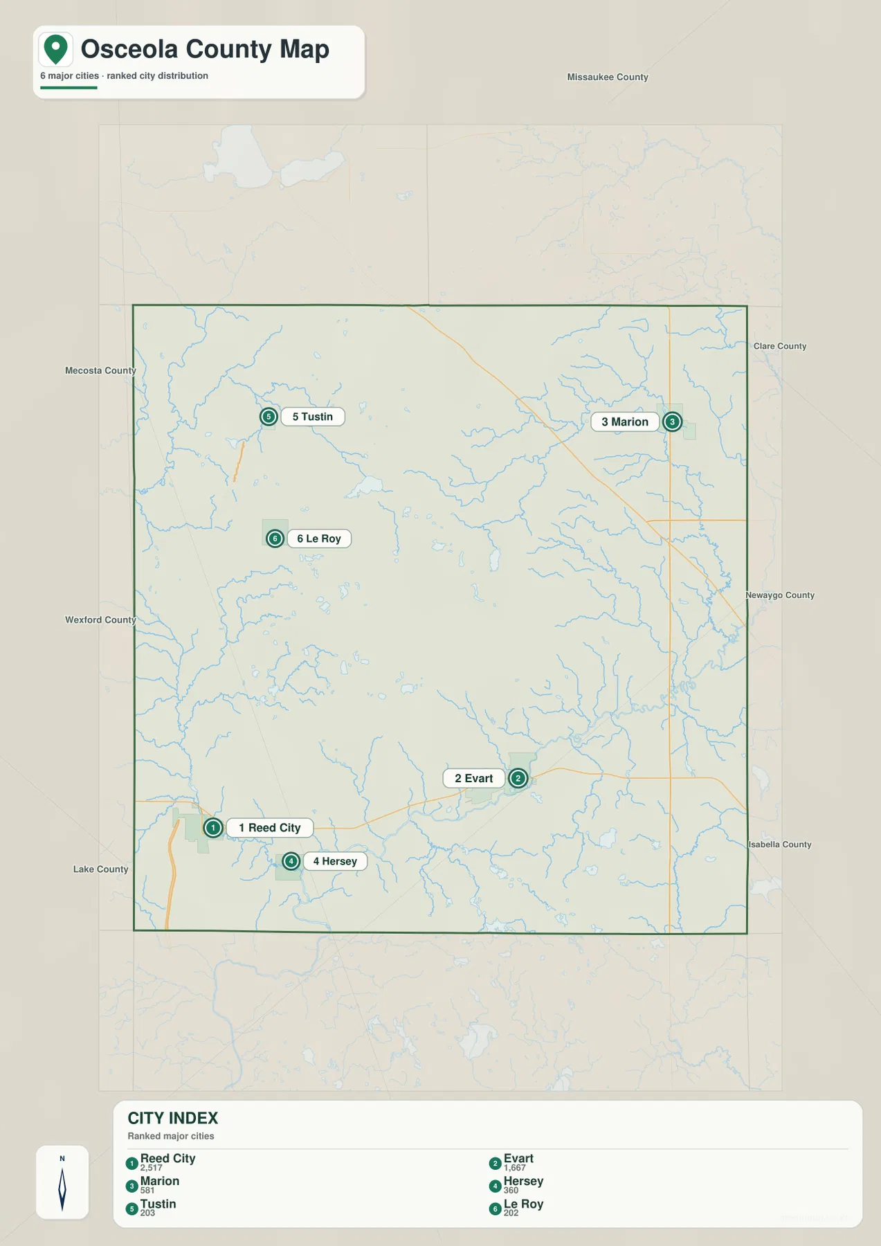
The Library of Michigan lists Evart, Reed City, Hersey, LeRoy, Marion, and Tustin among Osceola County’s cities and villages. That list closely matches the six names selected for the index, although the map’s phrase “major cities” should not be read as a statement that every place has the same municipal classification. For general geographic reading, the distinction is less important than the distribution. For administrative questions, mailing addresses, or local government services, the appropriate municipal or county source should be used instead.
The index is especially helpful when explaining how concentrated the southern part of the county is compared with the north. Reed City, Hersey, and Evart form a broad southern grouping, while Tustin and Le Roy sit farther inland to the northwest and Marion stands by itself near the eastern side. A reader who starts with the index can then return to the county map and attach each place to a road: US-10 for Reed City and Evart, US-131 for the western side, and M-66 for the route toward Marion.
Pine River and the Middle Branch system divide the northwest and east into different watersheds
The terrain-and-water map gives the northwest a strong identity through Pine River. East Branch Pine River joins the larger channel near the upper-left portion of the county, and numerous smaller streams feed the same area. This drainage is close to the western interior where Tustin and Le Roy appear on the general map. Rather than running across the entire county, Pine River serves as the major water reference for the northwest, while other parts of Osceola County belong to different river systems.
In the east, Middle Branch River and West Branch of Middle Branch River wind through a dense network of tributaries. This is the most intricate stream pattern on the supplied water map and is especially relevant to the area around Marion and the eastern county line. Rose Lake lies closer to the center-north, while Hicks Lake appears farther east. The combination of rivers, small tributaries, and scattered lakes makes the eastern half look very different from the broader Pine River channel in the northwest.
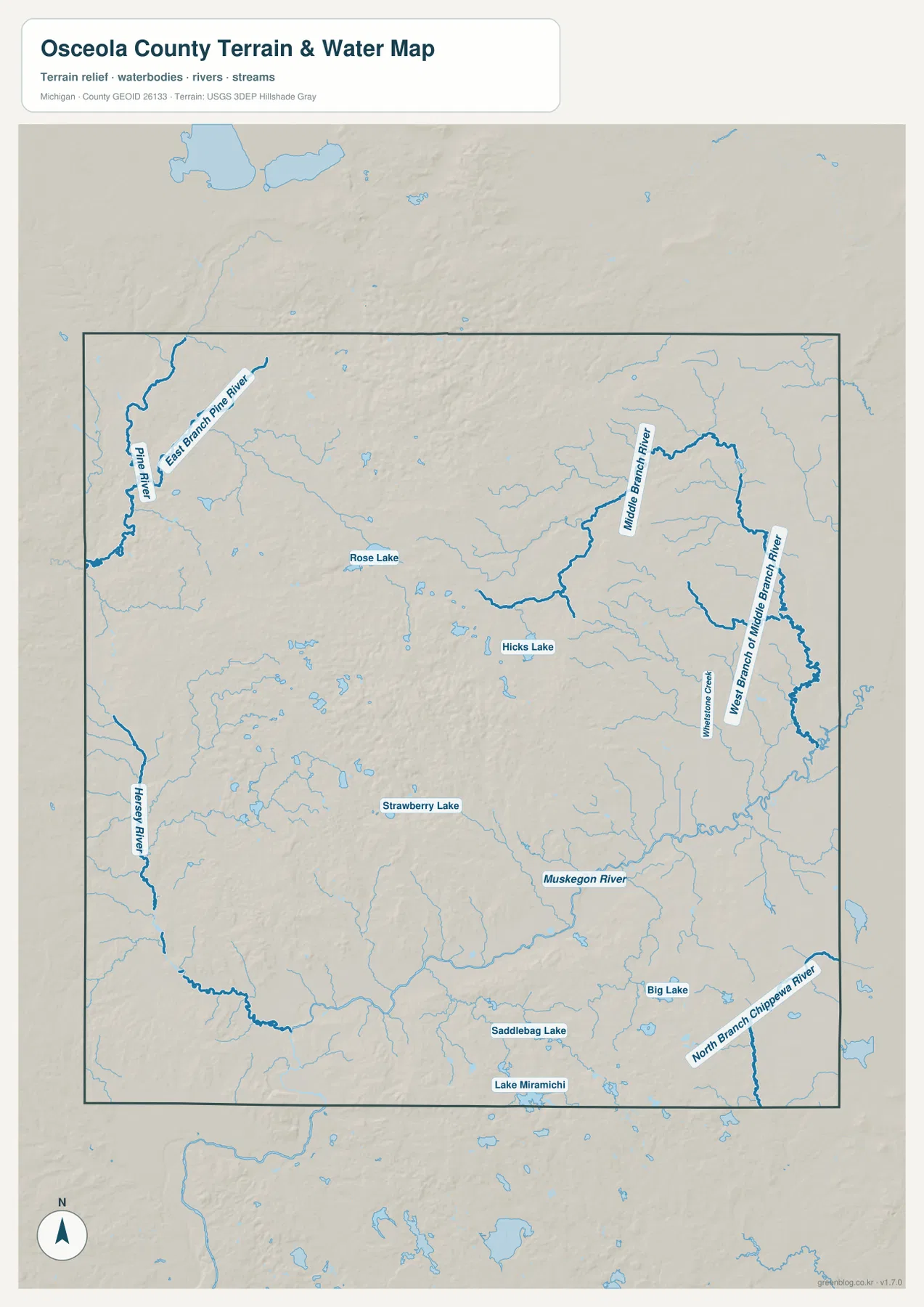
South of the county’s central uplands, the Muskegon River provides another major reference. Hersey River is shown toward the west and southwest, while North Branch Chippewa River appears in the southeast. Strawberry Lake, Saddlebag Lake, Lake Miramichi, and Big Lake add several recognizable water bodies across the southern half. Taken together, these features show why no single river can describe Osceola County’s hydrography. The county sits across several drainage areas, and the small lakes are useful landmarks between the larger channels.
The county’s own Parks Department connects two of those lakes to public recreation. Rose Lake Park is located on Rose Lake, and Crittenden Park is located on Big Lake. The official parks page also notes nearby trail connections, which gives the mapped water bodies a practical local context beyond their names. The water map itself is still a general reference. It does not provide flood zones, water depth, navigable channels, private-property access, current launch conditions, or water-quality advisories.
High north-central ridges contrast with the lower Muskegon River corridor
The elevation map has one of the clearest terrain contrasts in this part of the county series. Dark brown high ground dominates the north-central area, with another substantial elevated zone in the center. Moving east or south from those uplands, the colors shift through tan and yellow into greener low ground. A long lower band follows the southern river corridor, while the eastern side is generally lower than the prominent ridge system farther northwest. These patterns help explain the many short tributaries visible on the water map.
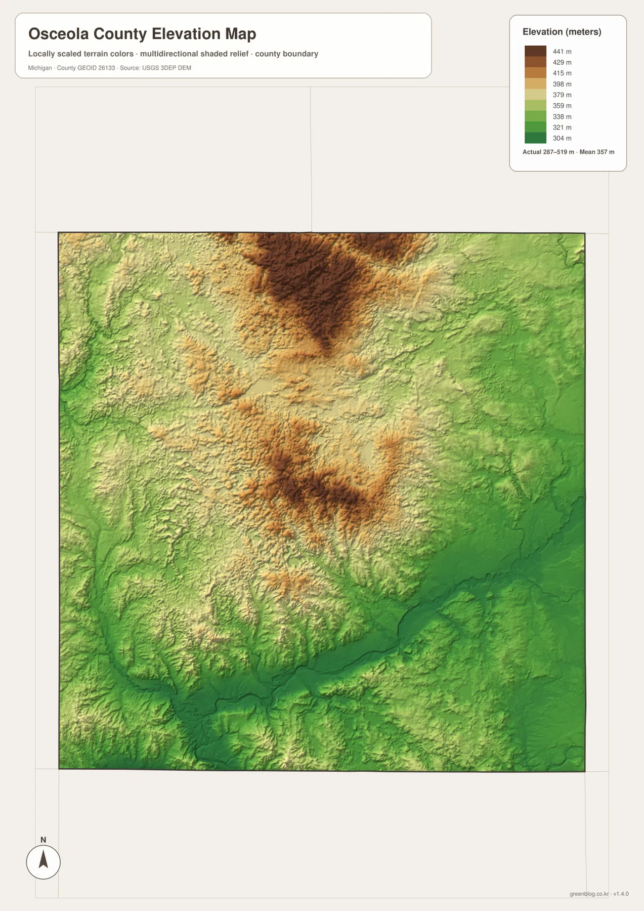
The legend uses representative elevation colors from about 304 to 441 meters, while the map separately reports an actual surface range of roughly 287 to 519 meters and a mean near 357 meters. The difference matters: the top color band is not the county’s absolute maximum. The colors are grouped to make broad terrain changes readable, while the printed actual range summarizes the full elevation surface. For county-scale interpretation, the strongest message is the concentration of higher ground in the north-central interior and lower land along the main river corridors.
Comparing the elevation and water maps helps connect shape with drainage. The Muskegon River runs through a lower southern corridor, and the eastern branches also occupy greener valleys relative to the high interior. Small lakes occur in and around the rolling terrain rather than forming one large lake district. The north-central ridge is separated from the lower eastern side by gradual transitions and stream-cut valleys. This gives Osceola County a rolling interior character that is easy to miss on a road-only map.
The elevation image is a generalized county reference, not a survey or engineering surface. It should not be used to determine the exact elevation of a house, road grade, drainage design, flood status, or construction site. Those tasks require original USGS elevation data, detailed contours, and sometimes field measurements. For a classroom map, regional description, or comparison between uplands and river valleys, however, the color bands make the county’s relief much easier to explain.
Rose Lake and Big Lake connect the mapped landscape with county parks and trails
The smaller lakes deserve attention because they are useful local landmarks between the larger rivers. Rose Lake sits north of the county’s center, Hicks Lake lies farther east, and Strawberry Lake appears in the south-central interior. Saddlebag Lake and Lake Miramichi are closer to the southern edge, while Big Lake is positioned in the southeast. Their names help orient parts of the county where the road map carries fewer large settlement labels. They also show that local recreation and settlement are tied to many modest inland lakes, not just to the major river corridors.
Osceola County Parks identifies Rose Lake Park on Rose Lake and Crittenden Park on Big Lake. The department notes that both parks are lakefront facilities and places Rose Lake Park near the White Pine Trail and Crittenden Park near the Pere Marquette State Trail. Those official descriptions provide a useful bridge between the static water map and places people may actually visit. Park boundaries and complete trail alignments are not drawn on the supplied county maps, so anyone planning a visit should use the county’s current park maps and operating information as well.
Different parts of the county are easiest to understand with different reference points. For Reed City and Evart, begin with US-10 and the Muskegon River corridor. For Marion, the M-66 road and the eastern Middle Branch drainage are more useful. Tustin and Le Roy make more sense when placed beside US-131 and the northwest Pine River system. This is one reason the map set works best as a group: roads identify travel corridors, water names valleys and lake districts, and elevation explains why those valleys and uplands differ.
Match the map to the question instead of forcing every detail into one view
The general county map carries the broadest mix of information, including major settlements, county boundaries, and the main state and federal highways. The city index is cleaner when the task is simply to compare the locations of Reed City, Evart, Marion, Hersey, Tustin, and Le Roy. The water map is the better reference for Pine River, the Middle Branch system, the Muskegon River, and the named lakes. The elevation map adds vertical context by separating the high interior ridges from the lower eastern and southern valleys.
For Osceola County, the ZIP bundles the four source JPGs behind the page: the road-and-place county map, ranked community index, terrain-and-water map, and elevation layer. Every image is 2572 × 3638 pixels in A3 portrait proportions. That resolution preserves labels such as M-115, Pine River, and the smaller named lakes better than a screenshot when the maps are placed in class handouts, county profiles, or printed reference sheets. Check the final print scale if those smaller labels matter.
The Osceola County sheets are broad-reference maps, not substitutes for parcel records, emergency routing, flood studies, or site engineering. Property work should return to the appropriate local record, county boundaries can be checked against Census TIGER/Line data, rivers and lakes against USGS National Hydrography, and precise height work against USGS 3D Elevation Program data. For ordinary regional explanation the four views are intentionally simple; decisions that depend on current conditions or exact measurements need the original agency data.
Frequently Asked Questions
Which map best shows the relationship between Reed City and Evart?
Start with the general county map. Reed City and Evart both sit along US-10 in the southern part of Osceola County, with Hersey between the broader western and eastern parts of that corridor. US-131 passes near Reed City, while M-66 becomes important east of Evart. The city index also highlights Reed City and Evart as the first two ranked places, but it omits much of the road detail.
Does the city index provide distances between the six ranked communities?
No. This city-index version shows Reed City, Evart, Marion, Hersey, Tustin, and Le Roy with rank markers, but it has no connector lines and no mileage values. It should be read as a distribution graphic rather than a distance chart. Use a current routing service when driving distance or travel time is needed.
What terrain contrast is most visible on the Osceola County elevation map?
The strongest contrast is between the high north-central and central uplands and the lower eastern and southern valleys. The map reports an actual elevation surface of roughly 287 to 519 meters, with a mean near 357 meters. Those figures are appropriate for county-scale comparison, not parcel surveying or engineering work. Pairing the elevation layer with the water map makes the lower Muskegon River and eastern stream corridors especially easy to recognize.
Map File Information
Get the Osceola County JPG set in one ZIP, including the road-and-place, community-index, water, and elevation views shown above.
- Included Files: county map, city map, water map, elevation map
- File Type: ZIP containing 4 JPG files
Related Maps
Sources and references
- Osceola County, Michigan — official county information and local government reference
- Osceola County Parks — official information for Rose Lake Park, Crittenden Park, and nearby trails
- Library of Michigan – Osceola County — county history, townships, cities, and villages
- U.S. Census Bureau – TIGER/Line Shapefiles — county boundary and base-geography reference
- U.S. Geological Survey – National Hydrography — river, stream, and lake reference data
- U.S. Geological Survey – 3D Elevation Program — elevation and terrain reference data
Green Map creates custom-edited map images using open geographic data sources such as geoBoundaries, Natural Earth, OpenStreetMap, and government open data. These maps are edited visual materials, not raw data files, and are provided for education, documents, presentations, and graphic reference.