Newaygo County sits in the western interior of Michigan’s Lower Peninsula, where Fremont, Newaygo, White Cloud, and Grant form a loose network of small communities rather than one dominant urban center. M-37 provides the clearest north-south reference, while M-82, M-20, and M-120 help connect the western and eastern parts of the county. The maps on this page also show a strong natural contrast between the Muskegon River corridor in the south and higher uplands toward the east and northeast. The same maps are available as high-resolution A3 JPG files in a downloadable ZIP archive.
The county becomes easier to understand when roads and water are considered together. Newaygo lies close to the Muskegon River, White Cloud is farther north along M-37, Fremont sits to the west, and Grant is near the southern edge of the county. Farther north, branches of the Pere Marquette River drain a different part of the landscape, while the White River system crosses the middle of the county. This combination of dispersed towns, wooded country, lakes, river valleys, and higher interior terrain gives Newaygo County a geography that changes noticeably from one part of the map to another.
Table of Contents
Fremont, Newaygo, White Cloud, and Grant anchor different parts of the county
The main county map highlights four especially useful reference places: White Cloud, Fremont, Newaygo, and Grant. White Cloud is slightly north of the county’s midpoint near the meeting of M-37 and M-20. Newaygo is farther south near the Muskegon River and the junction of M-37 and M-82. Grant continues south along M-37 near the county line, while Fremont is offset to the west. Their spacing makes it clear that the county’s principal communities are distributed across several corridors instead of forming a single compact metropolitan area.
Fremont is a useful starting point for understanding the western side. From there, Newaygo and White Cloud are both to the east, but they are reached through different road relationships. Newaygo and Grant line up more naturally along M-37, and White Cloud sits on the same north-south highway farther north. Thinking of M-37 as the central vertical reference and Fremont as a western community makes the overall arrangement easier to remember. The county map then adds streams, small lakes, and surrounding roads that explain why travel is not always as simple as a straight line between towns.
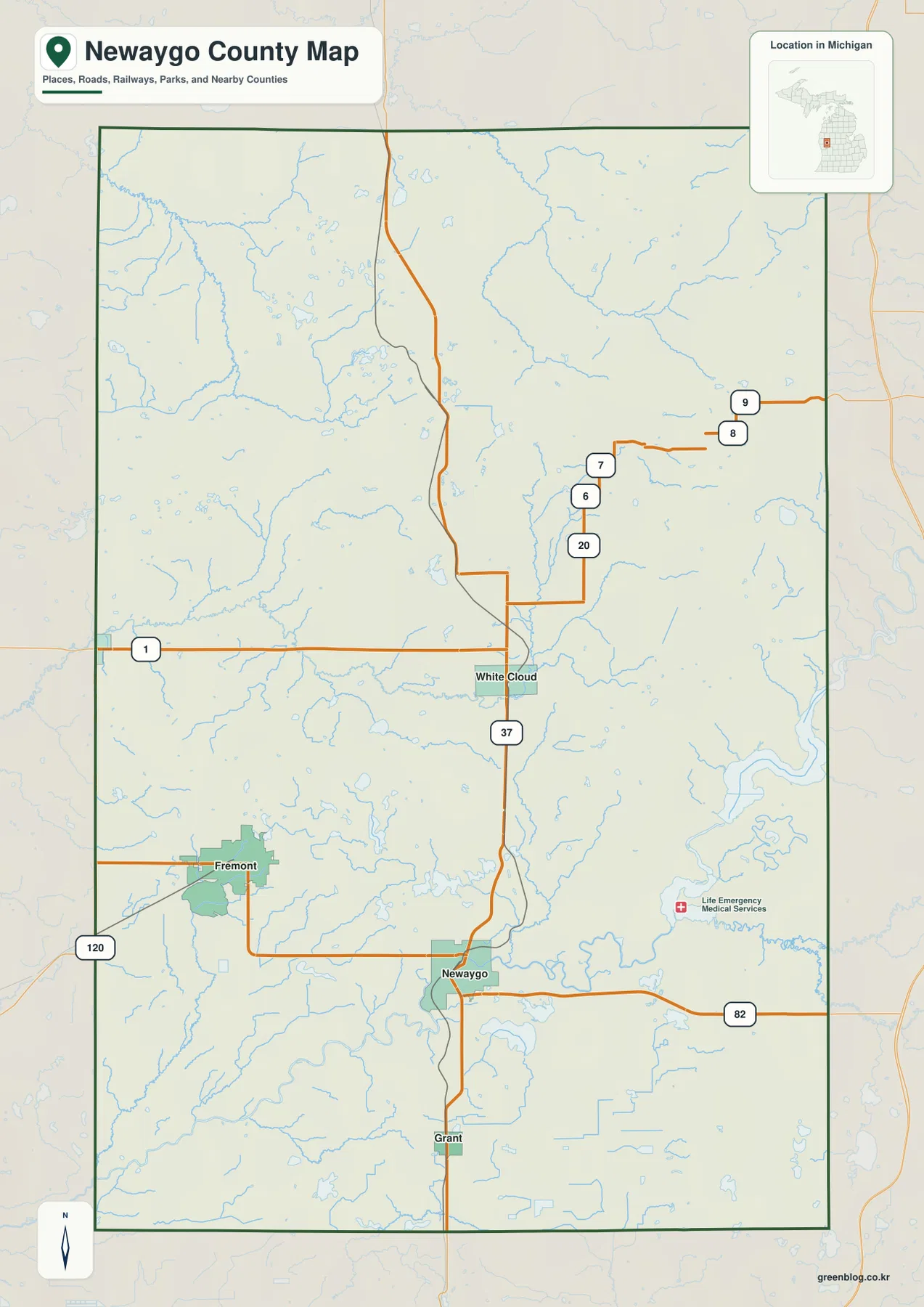
This map is most useful when towns, roads, and water need to be understood together. The Muskegon River bends through the southeastern part of the county, while many smaller streams and lakes appear around White Cloud and Fremont. The background also extends beyond the county boundary enough to provide directional context for neighboring areas. It is not a parcel map or a legal boundary survey, however. Anyone who needs exact property lines, road rights-of-way, or legally authoritative boundaries should use the appropriate county or state land records rather than a countywide reference map.
M-37 provides the simplest road reference from Grant to White Cloud
M-37 is the most obvious north-south road on the county map. Entering from the south, it passes Grant, continues through Newaygo, and reaches White Cloud before heading toward the northern county line. That single route establishes the order of three important communities. M-82 crosses the southern part of the county through Newaygo and continues eastward, while M-20 provides an east-west reference near White Cloud. Together, those routes make the central road pattern easier to explain than a long list of smaller numbered roads.
M-120 appears along the western side and helps orient the Fremont area toward communities beyond the county. Several additional numbered local roads are visible in the north and northeast, but they do not need to be treated as major statewide corridors to understand the map. The purpose of this page is to show where towns, rivers, and broad travel directions relate to one another. Actual driving conditions can change because of construction, seasonal closures, bridge work, or local restrictions, so current navigation and transportation sources should be consulted before a trip.
Newaygo is especially important as a road-and-river reference because M-37 and M-82 meet near a major bend of the Muskegon River. A short straight-line separation on a county map does not always translate into a short drive when roads must follow valleys or cross water at limited points. The same caution applies in the more rural northern and eastern parts of the county. The main map works well for countywide orientation, but turn-by-turn travel should always rely on a current road map or navigation service.
The city-connections map uses Fremont as a hub for straight-line comparisons
The city-connections map places Fremont at the hub and links it to Newaygo, White Cloud, Grant, and Hesperia. Those connectors represent straight-line distances in miles, not road mileage and not suggested driving routes. That distinction matters because Newaygo County contains winding rivers, lakes, and a road network that does not always follow the shortest line between two communities. The graphic is best used to compare general direction and separation from Fremont, while a navigation map is better for estimating travel time.
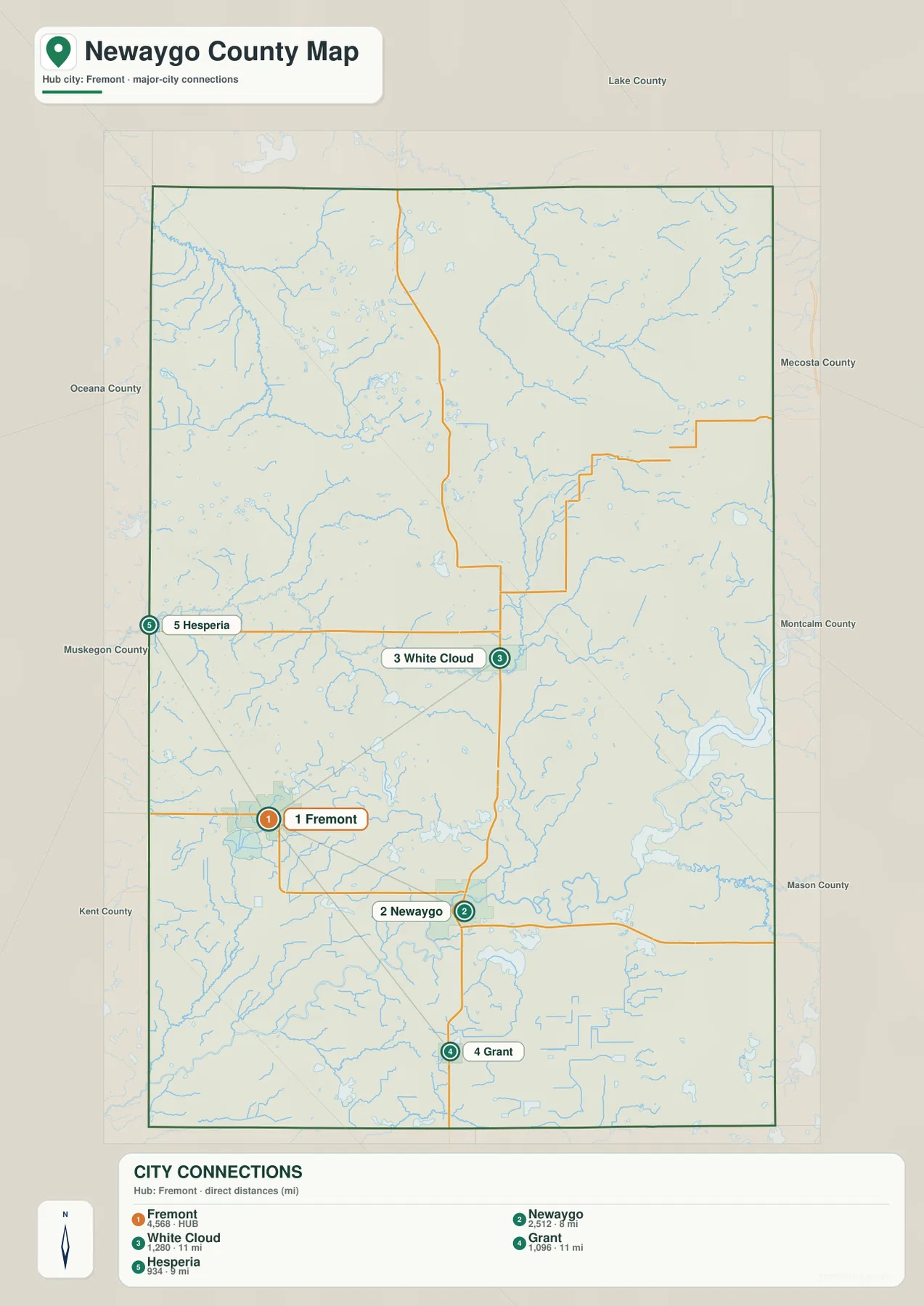
On this simplified map, White Cloud is northeast of Fremont, Newaygo is southeast, Grant is farther south, and Hesperia sits near the northwest side of the county. The lines make it obvious that Fremont is not in the geographic center of every major community; instead, it provides a western point from which the other selected places spread in several directions. This is useful for a classroom graphic, presentation, or quick orientation because it removes much of the small-road detail that can distract from the settlement pattern.
The city graphic should be used with the main map rather than as a replacement for it. The county map explains why Newaygo and Grant relate closely to the M-37 corridor, while Fremont is connected through a different set of roads. It also shows the Muskegon River near Newaygo and the dense network of small streams and lakes throughout the county. When the subject is simply where the principal towns are, the city map is cleaner. When the subject includes roads, water, or surrounding communities, the main county map provides the needed context.
Three major river systems divide the county’s water geography
The water map is dominated in the southeast by the Muskegon River. The river enters the county from the east, bends through a broad low corridor, and expands into Hardy Dam Pond and Croton Dam Pond. The Little Muskegon River joins the system near the Croton area. This large river-and-impoundment complex is one of the clearest geographic features in Newaygo County, and it helps explain why the community of Newaygo and several recreation sites are closely associated with the southern river corridor.
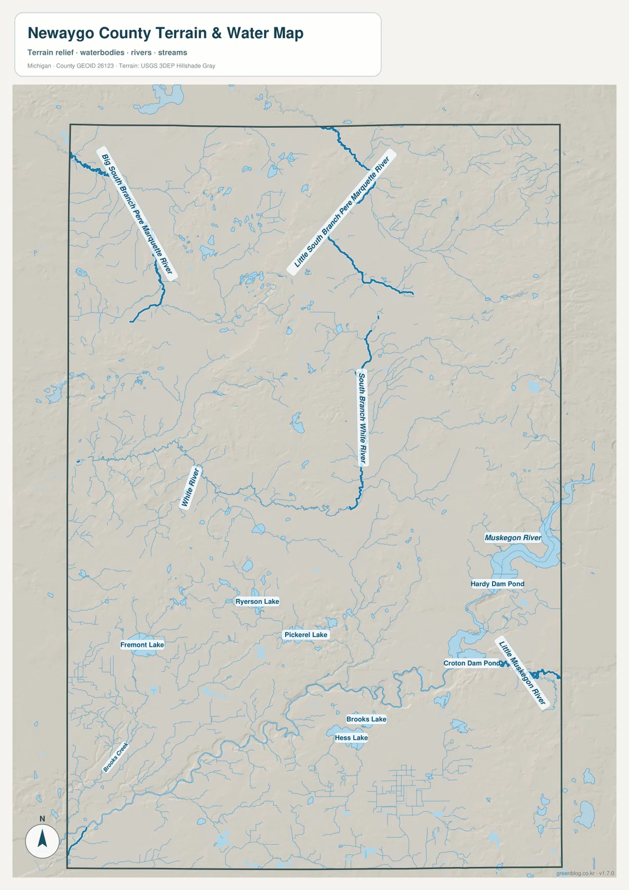
Farther north, the South Branch White River runs through the middle of the county and connects with the White River system toward the west. The northern part of Newaygo County is different again: the Big South Branch Pere Marquette River appears in the northwest, while the Little South Branch Pere Marquette River crosses the north-central area. Seeing those names on one map makes it clear that the county does not drain toward only one river. Different parts of the landscape feed the Muskegon, White, and Pere Marquette systems.
Several lakes provide local reference points. Fremont Lake is next to Fremont, Ryerson Lake and Pickerel Lake are farther east, and Brooks Lake and Hess Lake lie south of Newaygo. The official Newaygo County website describes more than 230 natural lakes and more than 350 miles of rivers and streams within the county. Not every small waterbody can be labeled on a county-scale graphic, but the concentration of blue lines and lake shapes on the map supports the broader picture of a heavily watered landscape.
This map is a geographic reference, not a flood, boating, fishing-regulation, or dam-operations product. It does not show water depth, current speed, launch conditions, private-property boundaries, or changing reservoir levels. That limitation is especially important around Hardy Dam Pond and Croton Dam Pond, where water management and recreation conditions can change. For safety-sensitive decisions, use current information from the responsible agencies. For regional explanation, however, the map is very effective at showing how lakes, tributaries, and the main river corridors fit together.
Low Muskegon River terrain contrasts with higher eastern and northeastern uplands
The elevation map adds a different layer to the county story. Darker greens mark lower terrain across much of the south and along the Muskegon River corridor. Moving east and northeast, the colors shift toward yellow, orange, and brown as the land rises. A broad area near the eastern boundary contains some of the highest terrain on the map, and additional ridges appear through the north-central interior. The west is generally lower, although rolling hills are still visible around Fremont and other interior areas.
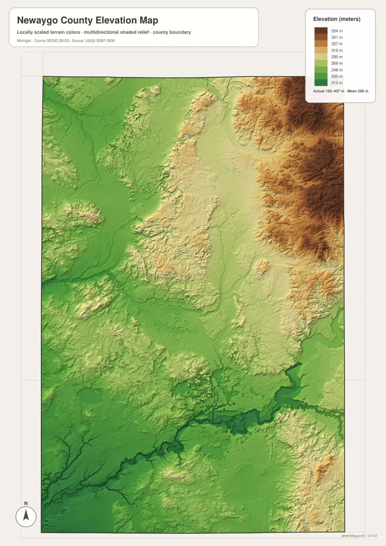
The legend reports an actual elevation range of roughly 183 to 407 meters, with a mean near 266 meters. Those figures are useful for county-scale comparison, but they should not be interpreted as survey elevations for individual properties. The shaded surface is generalized so broad hills and valleys are easy to recognize. It is not suitable for determining building elevations, road grades, drainage engineering, or flood safety. For precision work, use the underlying USGS 3D Elevation Program data or a professional survey appropriate to the site.
Comparing the elevation and water maps explains why the Muskegon River stands out so clearly. The river and its dam ponds occupy a lower band, while many smaller tributaries descend from higher country to the north and east. The White River system and Pere Marquette branches also follow lower channels between rolling uplands. For a geography lesson or regional presentation, placing the water and elevation maps side by side is more informative than showing either one alone because the relationship between valleys, streams, and higher ground becomes visible.
National forest and river recreation give the rural map a practical context
The official county website notes that more than half of Newaygo County lies within the Manistee National Forest. The main county map does not draw every national-forest boundary in detail, but the sparse settlement pattern, many streams, and extensive interior areas fit that broader rural character. The county also highlights the Muskegon River, camping, fishing, hunting, and other outdoor activities as important parts of local recreation. In other words, the map makes more sense when the communities are viewed as places embedded within a large forest-and-water landscape rather than as isolated dots on a road network.
Newaygo County Parks lists Hardy Dam County Marina, Sandy Beach County Park, Ed Henning County Park, Diamond Lake County Park, White Cloud County Park, and several other facilities. Hardy and Croton are especially easy to locate because their large impoundments appear directly on the water map. White Cloud County Park provides a reference in the north-central part of the county, while Fremont Lake helps orient the western community of Fremont. The maps here are useful for getting countywide bearings before a visit, but current hours, reservations, water conditions, parking, and access rules should be checked with the park or managing agency.
For trip planning, the most useful map depends on the purpose. Drivers moving among towns can begin with the county map and use M-37, M-82, and M-20 as anchors. Visitors focused on reservoirs, rivers, or lakes can start with the water map to find the Muskegon River, Hardy Dam Pond, Croton Dam Pond, and the smaller lake groups. Hikers and students interested in terrain can add the elevation map to see how the eastern uplands differ from the lower southern river corridor. Separating those tasks keeps each map readable and avoids forcing too much information into one graphic.
Choose the map according to the question you need to answer
Use the main county map for a broad overview of towns, major roads, waterways, and the county boundary. It is the best single choice when White Cloud, Fremont, Newaygo, Grant, M-37, M-20, and M-82 all need to appear together. Use the city-connections map when the goal is a cleaner comparison of Fremont with Newaygo, White Cloud, Grant, and Hesperia. Remember that its connectors show straight-line distance rather than road mileage, so it should not be presented as a routing diagram.
Choose the water map for river systems, reservoirs, and named lakes. It makes the southeastern Muskegon River system, the White River drainage, and northern Pere Marquette branches much easier to distinguish than the general map does. Choose the elevation map for topographic contrast, especially the lower Muskegon River valley and the higher eastern and northeastern interior. In a report or presentation, a useful sequence is to begin with the county map, move to the city or water map depending on the topic, and finish with elevation when physical terrain matters.
The downloadable originals are 3638 × 2572 pixel JPG files prepared for A3 landscape use. They work well in school projects, regional overviews, presentations, and printed reference sheets. Check scaling and margins before printing so smaller labels remain readable. These files are not legal boundary surveys, parcel maps, emergency navigation products, flood maps, or engineering drawings. When a decision depends on precise location, current conditions, or legal status, consult the responsible government agency and the most recent specialized dataset.
Frequently Asked Questions
Which map is best for comparing Fremont, White Cloud, and Newaygo?
The main county map is the best choice when roads and water need to be included. Fremont is in the west, White Cloud is north-central, and Newaygo is farther south near the Muskegon River, with Grant continuing south along M-37. The city-connections map provides a simpler comparison from Fremont, but its lines represent straight-line distances rather than driving routes. For actual travel, use the county map for orientation and a current navigation service for road mileage and travel time.
Where can I see the Muskegon River, Hardy Dam Pond, and Croton Dam Pond?
The water map shows them most clearly in the southeastern part of Newaygo County. The Muskegon River expands into Hardy Dam Pond and Croton Dam Pond, and the Little Muskegon River joins the system near the Croton area. The same map also labels the White River system, northern Pere Marquette River branches, Fremont Lake, Ryerson Lake, Pickerel Lake, Brooks Lake, and Hess Lake. Reservoir levels, boating conditions, and dam operations should be checked through current agency information rather than this reference map.
What is the strongest terrain contrast on the elevation map?
The clearest contrast is between the lower Muskegon River corridor in the south and higher uplands toward the east and northeast. The map’s legend shows an actual elevation range of about 183 to 407 meters and a mean near 266 meters. Those values are intended for regional comparison. They should not be used as parcel-level survey elevations or as the basis for engineering, construction, drainage, or flood decisions.
Map File Information
Download the high-resolution JPG versions of the Newaygo County maps used on this page in one ZIP archive.
- Included Files: county map, city map, water map, and elevation map
- File Type: ZIP containing 4 JPG files
Related Maps
Sources and references
- Newaygo County official website — county overview, lakes, rivers, forest, and local information
- Newaygo County Parks – Campgrounds — county parks and outdoor recreation around lakes and rivers
- U.S. Census Bureau – TIGER/Line Shapefiles — county boundaries and base geography
- U.S. Geological Survey – National Hydrography — rivers, streams, and waterbody reference data
- U.S. Geological Survey – 3D Elevation Program — elevation and terrain reference data
Green Map creates custom-edited map images using open geographic data sources such as geoBoundaries, Natural Earth, OpenStreetMap, and government open data. These maps are edited visual materials, not raw data files, and are provided for education, documents, presentations, and graphic reference.