Muskegon County sits on the eastern shore of Lake Michigan, where a concentrated lakeshore urban area meets broad river valleys and a more rural interior. Muskegon, Norton Shores, Muskegon Heights, and North Muskegon cluster around Muskegon Lake, while Whitehall and Montague form a second northern focus near White Lake. Farther inland, places such as Twin Lake, Wolf Lake, Fruitport, Ravenna, and Casnovia help show how far the county extends away from the shore. The maps on this page cover county boundaries, major places and roads, water features, and elevation, and the same maps are available as high-resolution A3 JPG files in a downloadable ZIP archive.
The county is easiest to understand by starting with its water. The Muskegon River approaches from the east, enters Muskegon Lake, and then reaches Lake Michigan through the Muskegon Channel. In the north, the White River enters White Lake before reaching the Lake Michigan shoreline. These two large lake-and-river systems organize much of the western half of the county, while US-31 provides the most obvious north-south road connection along the populated side of the map. Moving eastward, M-46 and I-96 connect the lakeshore with the interior, where the terrain generally rises and settlements become more widely spaced.
Table of Contents
A Lake Michigan county with an urban shore and a long inland reach
Lake Michigan forms the western edge of Muskegon County. The Archives of Michigan county guide identifies Oceana County to the north, Newaygo County to the northeast, Kent County to the east, and Ottawa County to the south. The boundary is not a simple rectangle. The eastern side reaches toward Casnovia in a long projection, while the western side follows the Great Lake shoreline. That shape matters when reading the map because a place near downtown Muskegon can be much closer to Lake Michigan than to communities near the county’s eastern edge.
The county map makes the contrast clear. Muskegon, Muskegon Heights, Norton Shores, and North Muskegon occupy a compact area near Muskegon Lake and the Lake Michigan coast. Whitehall and Montague are farther north at White Lake, while Twin Lake and Lakewood Club sit inland between the two lake-centered areas. Wolf Lake appears east of Muskegon along the M-46 corridor, and Fruitport, Ravenna, and Casnovia mark the southern and eastern parts of the county. Those place names turn what might look like a broad blank interior on a statewide map into a set of recognizable local reference points.
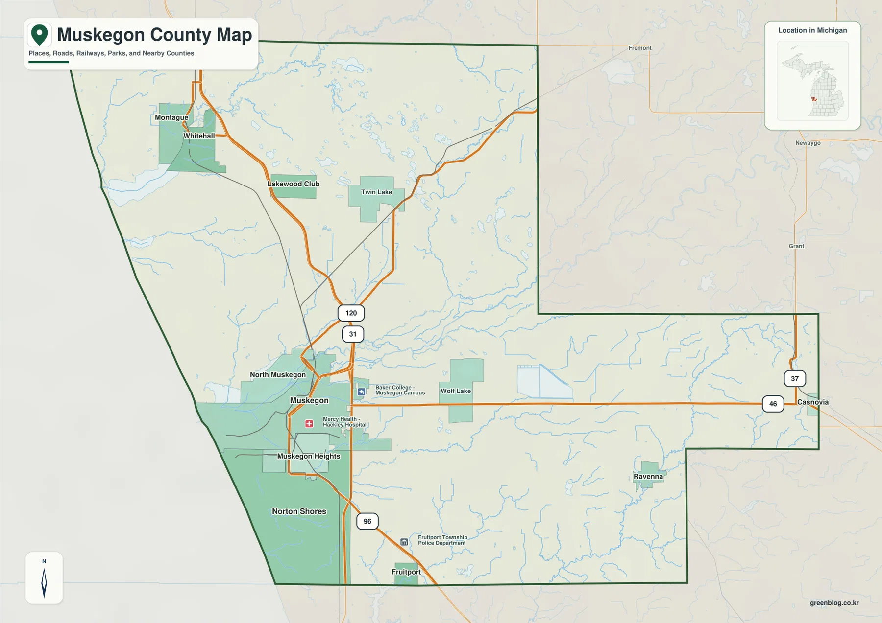
The map also helps distinguish the city of Muskegon from the larger county that shares its name. The city occupies only part of the southwestern lakeshore area, while the county stretches north to White Lake and east toward the Kent County line. North Muskegon is separated from central Muskegon by Muskegon Lake, and Norton Shores extends south and southwest toward the Lake Michigan shoreline. Reading the shoreline, the inland lakes, and the roads together is much more useful than relying on city names alone.
US-31, I-96, M-46, M-120, and M-37 provide the road framework
US-31 is the strongest north-south reference line on the county map. It passes through the western side of the county, linking the Muskegon-Norton Shores area with Whitehall and the communities farther north. Because most of the county’s larger cities are near this corridor, finding US-31 first is a practical way to orient the rest of the map. It also shows how the two main lakeshore settlement groups, Muskegon around Muskegon Lake and Whitehall-Montague around White Lake, fit into the same western travel corridor.
I-96 begins in the Muskegon area and runs southeast toward the interior. Muskegon County’s official economic development page highlights I-96 as one of the county’s major access routes, and the map shows why: it carries traffic away from the Lake Michigan side toward the Grand Rapids region. M-46 serves a different purpose by crossing the county east-west from the Muskegon area through Wolf Lake toward Casnovia. Together, I-96 and M-46 make the county’s eastern reach easier to understand because they connect the dense western urban area with places that are much farther from the coast.
M-120 branches northeast from the Muskegon area toward Twin Lake and the northeastern interior, while M-37 appears near the eastern side around Casnovia. The map is useful for regional orientation, but it should not replace a current navigation service for driving. Interchanges, temporary construction, winter conditions, and local road restrictions can change. For classroom work, regional planning notes, or a printed county overview, however, these roads provide a simple framework: US-31 for the western north-south corridor, M-46 for the central east-west crossing, I-96 for the southeast regional connection, and M-120 and M-37 for access into the northern and eastern interior.
The city index reveals how strongly population centers favor the western lakeshore
The city index map ranks six major cities. Muskegon is first, followed by Norton Shores, Muskegon Heights, Roosevelt Park, North Muskegon, and Whitehall. Five of the six are packed into the Muskegon Lake-Lake Michigan area, while Whitehall stands apart in the north near White Lake. The pattern is visually strong even without using the population figures printed in the index: most of the ranked urban places occupy a small part of the county’s total land area.
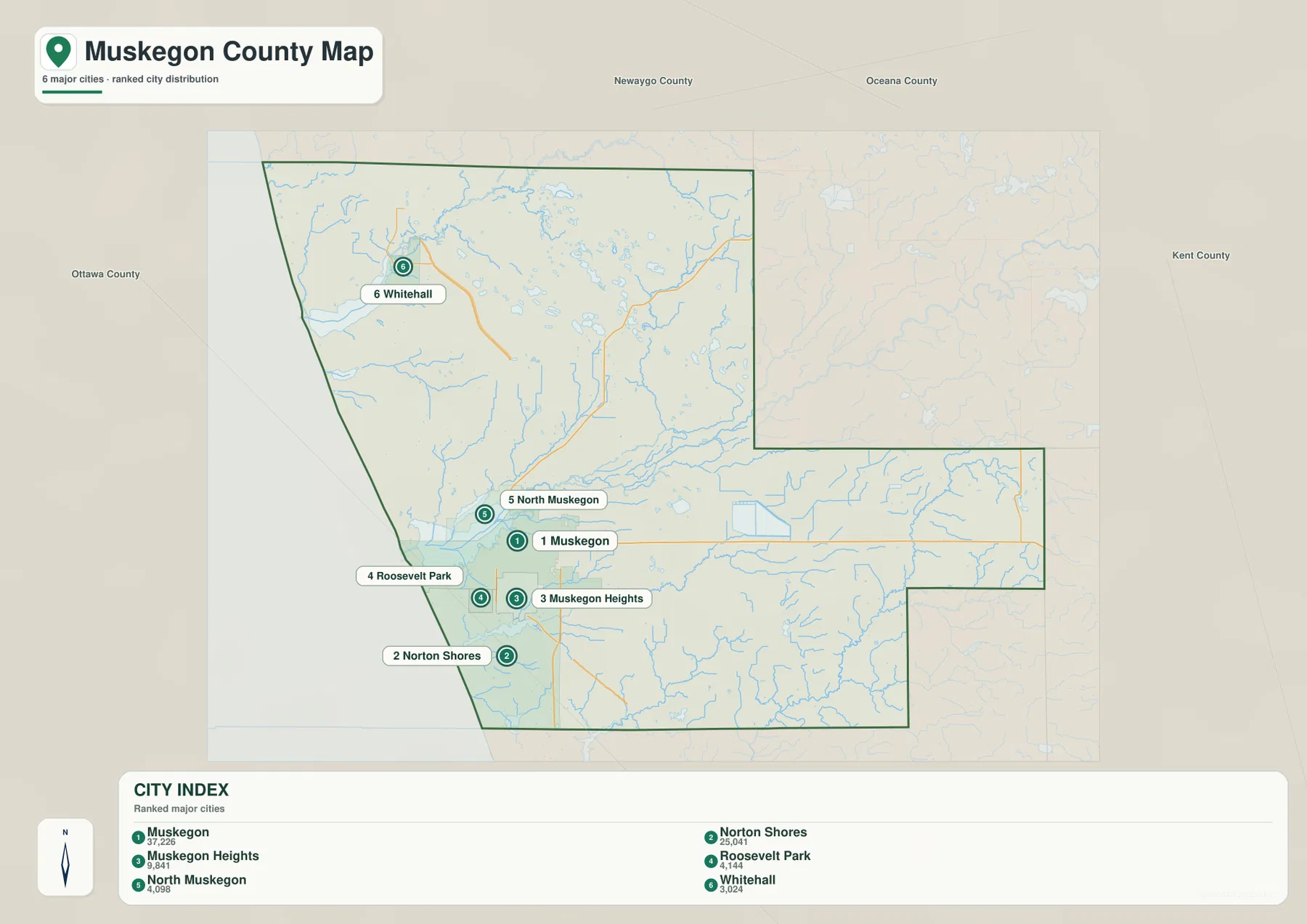
This index is not a complete settlement map. Montague, Twin Lake, Wolf Lake, Fruitport, Ravenna, Casnovia, and other named places appear on the broader county map but are not all part of the ranked city list. The difference is useful rather than contradictory. Use the city index when the question is where the principal incorporated urban places are concentrated, and use the county map when the goal is to understand the full spread of communities, roads, parks, and county edges.
Water helps explain the city pattern. Muskegon and North Muskegon face different sides of Muskegon Lake. Norton Shores extends toward the Lake Michigan coast and Mona Lake, while Whitehall occupies the southern side of White Lake opposite Montague. These are not isolated blue features placed behind the cities; they are major geographic anchors. A reader who first identifies Muskegon Lake and White Lake can usually make sense of the city distribution much faster than someone who begins with the county boundary alone.
Muskegon River, White River, and a chain of coastal lakes define the water map
The Muskegon River is the dominant inland river shown on the water map. It enters the county from the east, runs west through the central part of the county, and reaches Muskegon Lake near the urban area. A North Channel of the Muskegon River is also labeled close to the lake. Muskegon Lake then connects to Lake Michigan through the channel at the western shore. This sequence is one of the county’s most important geographic relationships because it links the interior river system directly with a large inland lake, the city, the port area, and the Great Lake.
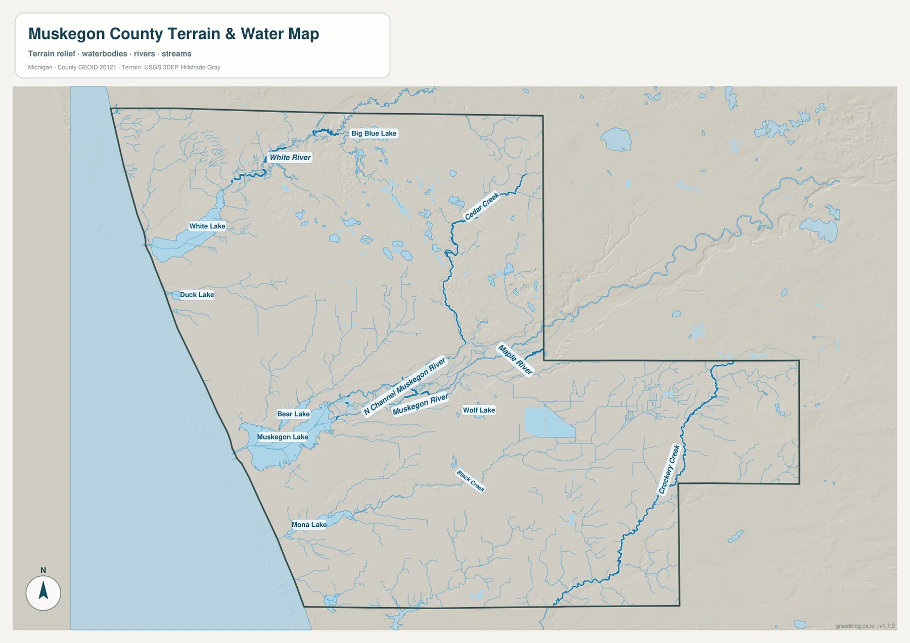
In the north, the White River flows into White Lake. Big Blue Lake appears farther inland, while Duck Lake lies along the Lake Michigan side south of White Lake. Farther south, Bear Lake sits just inland from Muskegon Lake, and Mona Lake lies below the main Muskegon urban area. Wolf Lake is farther inland near the M-46 corridor. Seeing these lakes together is useful because the county is not organized around a single body of water; instead, several lake and river systems create different local landscapes along the coast and inland.
Smaller streams fill in the eastern half of the picture. Cedar Creek is prominent in the north-central to northeastern interior, Maple River is labeled near the Muskegon River system, Crockery Creek runs through the southeastern portion, and Black Creek appears south of the Muskegon urban area. The map is intended for geographic reference, not for floodplain decisions, boating navigation, water depth, fishing regulations, or property boundaries. Those uses require current agency products from sources such as the USGS, FEMA, Michigan DNR, or local authorities.
Elevation rises away from the broad lowlands, with dunes adding relief near the coast
The elevation map changes the emphasis from names and roads to landform. Green areas dominate much of the Muskegon Lake and Muskegon River lowland, while warmer colors become more common toward the eastern and southeastern interior. The highest-looking terrain on the map is concentrated near the county’s eastern edge and in several interior ridges. The Lake Michigan shore is generally low, yet it is not uniformly flat: raised dune belts appear close behind parts of the coast, especially in the northwest and around the Muskegon lakeshore.
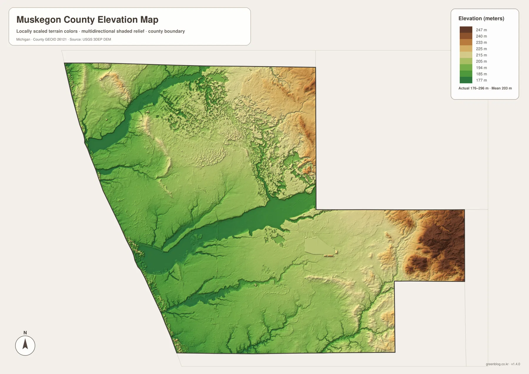
The map notes an actual elevation range of about 176 to 296 meters and a mean near 203 meters. Those numbers are useful for county-scale comparison, but they are not parcel-level survey measurements. A shaded-relief map generalizes the surface so that hills, valleys, and broad changes are easy to see. It should not be used to determine a building pad elevation, road grade, drainage design, or flood safety. For that kind of work, use survey-grade information or the underlying elevation data available through the USGS 3D Elevation Program.
Comparing the elevation and water maps reveals why the Muskegon River corridor stands out. The river and Muskegon Lake occupy a broad lower zone, while many tributaries descend from higher ground to the east. White River and White Lake also sit within a lower northern corridor. Along Lake Michigan, the rapid shift from shoreline lowland to dune ridges can occur over a much shorter distance. That combination of broad river valleys, coastal dunes, and higher inland terrain gives Muskegon County more topographic variety than a simple shoreline map would suggest.
Pere Marquette Park and the Lakeshore Trail connect the map to everyday recreation
At the western end of Muskegon Lake, the map’s lake-channel-shore relationship corresponds to one of the county’s best-known public waterfront areas. The City of Muskegon describes Pere Marquette Charter Park as a Lake Michigan beach bordered on the north by the Muskegon Channel. Nearby Lake Michigan Park and Kruse Park continue the public shoreline and dune landscape. These places give a real-world example of what the elevation map hints at: sandy beach lies close to steep or wooded dunes, while the channel links the inland lake to Lake Michigan.
The city also describes the Muskegon Lakeshore Trail as an approximately 12-mile paved route following the shoreline of Muskegon Lake and connecting parks, the channel area, and other waterfront destinations. The county map is not a trail map, but it provides useful orientation before a visit by showing where Muskegon Lake, the city, North Muskegon, and the Lake Michigan shore sit relative to one another. Trail access points, parking, closures, and seasonal conditions should always be checked on the current city or park website.
Visit Muskegon, the county visitor bureau, emphasizes the county’s Lake Michigan beaches, state parks, multi-use trails, and water recreation. Those attractions are spread over more than the central city, so the broad county view is helpful when deciding whether a trip will focus on Muskegon Lake, White Lake, a Lake Michigan beach, or inland recreation. The maps here are background geography rather than a complete tourism directory, but they make it much easier to understand how the major recreation areas relate to the county’s cities, highways, and water systems.
Choose the map that matches the question you are trying to answer
For a general county overview, start with the county map. It is the best choice when you need Muskegon, Norton Shores, Whitehall, Fruitport, Ravenna, Casnovia, US-31, I-96, M-46, M-120, and M-37 in the same frame. It also gives enough surrounding context to show where the county meets its neighbors. The city index is better for a simpler graphic focused on the ranked urban places, especially the dense Muskegon-area cluster and Whitehall in the north.
Use the water map when rivers, lakes, or drainage relationships are the main subject. It is especially effective for explaining how Muskegon River reaches Muskegon Lake, how White River reaches White Lake, and where Mona Lake, Duck Lake, Bear Lake, Wolf Lake, and smaller streams fit into the county. Use the elevation map when the goal is to contrast the low lakeshore and river corridors with higher inland terrain. In a presentation, placing the county map first and then switching to water and elevation creates a clear progression from human geography to physical geography.
The downloadable originals are 3638 × 2572 pixel JPG files prepared for an A3 landscape layout. They can be inserted into reports, presentations, and classroom material, or printed as reference sheets. Before printing, check margins and scaling so labels remain legible. These maps are not legal boundary surveys, parcel maps, emergency navigation products, flood maps, or engineering drawings. When a decision depends on precise location or current conditions, consult the responsible government agency and the most recent specialized dataset.
Frequently Asked Questions
Which map is best for comparing Muskegon, Norton Shores, and Whitehall?
Use the main county map when you want those places together with roads and surrounding communities. Muskegon and Norton Shores are in the western lakeshore urban cluster, while Whitehall is farther north near White Lake along the US-31 corridor. The city index also includes all three, but the county map adds Montague, Twin Lake, Fruitport, Ravenna, Casnovia, and the major highway network, so it provides more context for countywide orientation.
How do the Muskegon River and White River connect to Lake Michigan?
The Muskegon River flows into Muskegon Lake, which reaches Lake Michigan through the Muskegon Channel. Farther north, the White River flows into White Lake before that lake connects with the Lake Michigan shore. The water map shows both systems along with Mona Lake, Duck Lake, Bear Lake, Wolf Lake, and several tributaries, making it the most useful map for explaining the county’s river-and-lake geography.
What is the clearest terrain difference on the elevation map?
The broad Muskegon Lake and Muskegon River lowlands are generally lower, while higher terrain becomes more common toward the eastern and southeastern interior. Coastal dune ridges also create local relief close to Lake Michigan. The map reports an actual elevation range of about 176 to 296 meters and a mean near 203 meters, but it is intended for regional comparison rather than parcel-level surveying, engineering, or flood decisions.
Map File Information
Download the high-resolution JPG versions of the Muskegon County maps used on this page in one ZIP archive.
- Included Files: county map, city map, water map, and elevation map
- File Type: ZIP containing 4 JPG files
Related Maps
Sources and references
- Muskegon County official website — county government and regional information
- Archives of Michigan – Muskegon County Guide — adjacent counties, organization date, and archival background
- City of Muskegon – Pere Marquette Charter Park and Muskegon Lakeshore Trail — Lake Michigan beach and Muskegon Lake trail context
- Visit Muskegon — county beaches, parks, trails, and outdoor recreation
- U.S. Census Bureau – TIGER/Line Shapefiles — county boundaries, roads, and base geography
- U.S. Geological Survey – National Hydrography and 3D Elevation Program — water and elevation reference data
Green Map creates custom-edited map images using open geographic data sources such as geoBoundaries, Natural Earth, OpenStreetMap, and government open data. These maps are edited visual materials, not raw data files, and are provided for education, documents, presentations, and graphic reference.