Montmorency County sits in the forested interior of northeastern Michigan’s Lower Peninsula, where small communities are separated by long stretches of woods, lakes, and streams. Atlanta, the county seat, is the easiest place to use as a reference point; Hillman lies near the eastern edge, while Lewiston anchors the southwest. M-32 ties those communities together from west to east, and M-33 approaches Atlanta from the south. The maps on this page show those relationships from several angles, and the same map set is available as high-resolution A3 JPG files in a downloadable ZIP.
A quick way to understand the county is to start with roads and settlements, then add the waterways and relief. The general county map shows Atlanta, Hillman, Lewiston, Canada Creek Ranch, M-32, M-33, and a network of numbered county roads. The water map separates the Thunder Bay River system in the central and eastern part of the county from the Black River system in the northwest. The elevation map adds another layer, showing higher ground in the southwest and lower river valleys toward the east.
Table of Contents
Start with Atlanta and the M-32 corridor
Montmorency County is bordered by Presque Isle County to the north, Alpena County to the east, Oscoda County to the south, and Otsego County to the west. It does not reach the Lake Huron shoreline, but it occupies the inland part of northeastern Lower Michigan just west of the Alpena area. Looking west connects the county to the Gaylord and Otsego County side of northern Michigan, while looking east leads toward the Lake Huron region.
Atlanta is near the middle of the county and serves as the county seat. On the general map, it appears along M-32 near the northern end of M-33, making it a practical reference point for both east-west and north-south orientation. Hillman is farther east near the Alpena County line, and Lewiston is set well to the southwest. Canada Creek Ranch appears in the northwest, giving the map another recognizable place name outside the three best-known community centers.
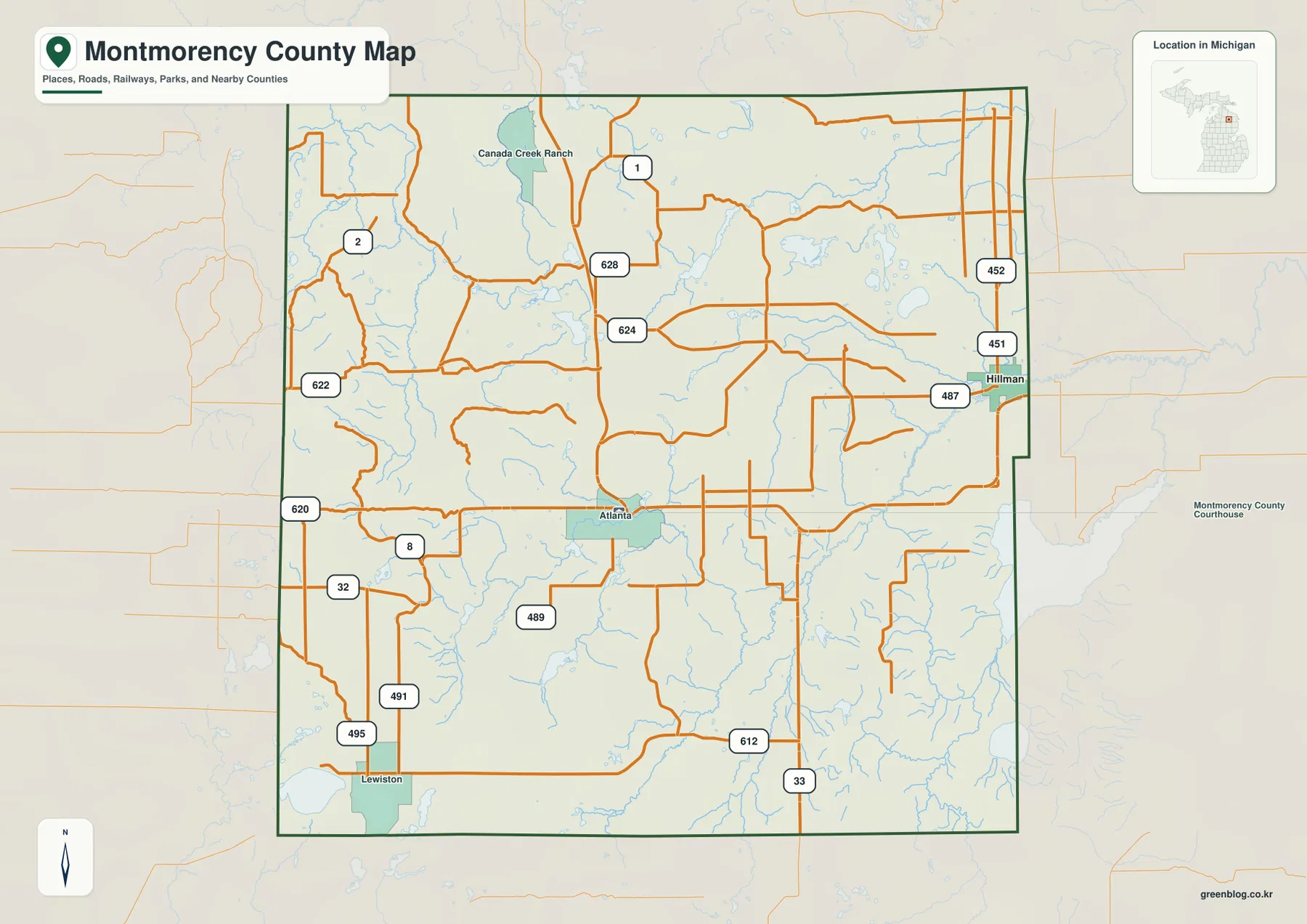
The map also labels county roads such as 620, 622, 624, 628, 451, 452, 487, 489, 491, 495, and 612. These routes make more sense after M-32 and M-33 are located first. M-32 gives the clearest east-west reference across the southern half of the county, while the local roads branch toward lakes, wooded areas, and smaller destinations. Near Hillman, several roads continue toward the eastern county line; around Lewiston, the road pattern opens toward Otsego and Oscoda counties.
Hillman and Lewiston help define opposite sides of the county
Montmorency County is not organized around one large urban center. Atlanta provides the administrative center, but Hillman and Lewiston are important geographic reference points because they sit on different sides of the county. Hillman lies close to the eastern boundary and is reached from Atlanta along the M-32 corridor. Lewiston is near the southwestern corner, where the county approaches both Otsego County and Oscoda County. Thinking of the three communities as separate points across a broad forested area makes the county’s scale easier to understand.
That pattern is consistent with the county’s sparse settlement. Roads and waterways cover much of the map, but there is no continuous band of urban development between the named communities. Large undeveloped areas separate the settlements, and many smaller roads serve lakes, forest properties, recreational land, and rural residences. For a school presentation or regional overview, it is usually clearer to explain Atlanta as the central reference, Hillman as the eastern community, and Lewiston as the southwestern community rather than simply listing their names.
Why the city-index map singles out Hillman
The city-index map has a narrower purpose than the general county map. It identifies Hillman as the single ranked major city in this particular index and repeats that name in the CITY INDEX panel. That does not mean Atlanta or Lewiston are absent from Montmorency County. Both appear on the general county map. The index image should be read as a selected-city view produced from a specific ranking rule, not as a complete inventory of every community in the county.
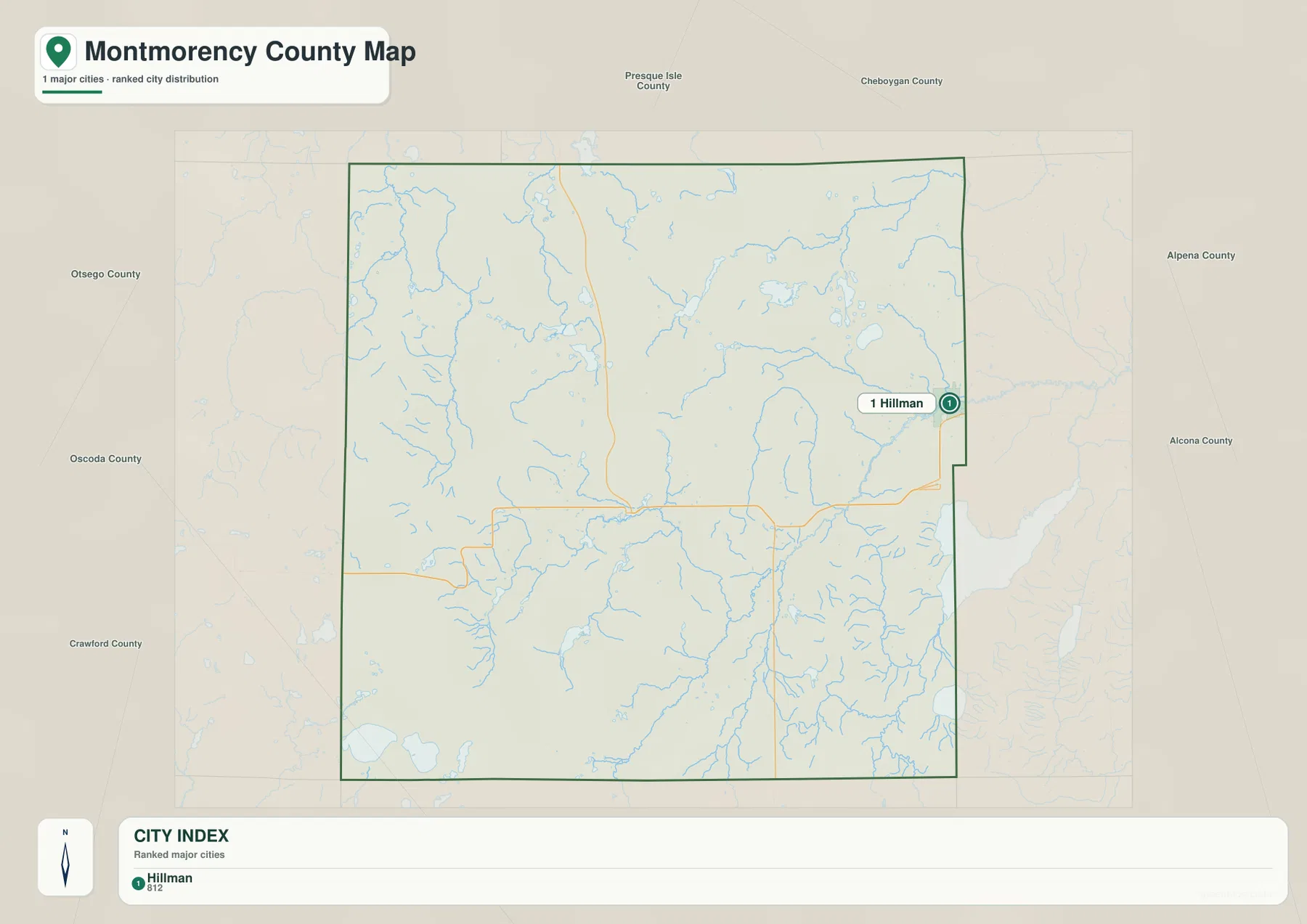
Hillman appears very close to the Alpena County line, which makes its eastern position immediately clear. The county outline, surrounding county labels, roads, and streams remain visible around the city marker, so the image is useful when Hillman itself is the subject. When the goal is to compare Hillman with Atlanta and Lewiston, however, the general county map is the better choice because all three communities are labeled there.
The Thunder Bay and Black River systems divide the water story
The terrain and water map shows that Montmorency County contains several distinct river branches rather than one simple drainage line. Thunder Bay River crosses the central-southern part of the county and continues eastward. North Branch Thunder Bay River runs across the northeast, while Upper South Branch Thunder Bay River follows the southeastern side near the county boundary. Numerous smaller tributaries connect to those rivers and fill the eastern half of the map with a dense network of streams.
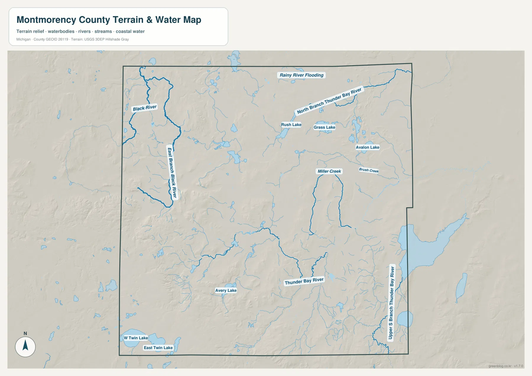
The northwest has a different set of named waterways. Black River and East Branch Black River stand out there, clearly separated from the Thunder Bay branches farther east and south. The map also labels Rush Lake, Grass Lake, Avalon Lake, Avery Lake, West Twin Lake, and East Twin Lake. Miller Creek and Brush Creek are among the smaller named streams in the eastern half, and Rainy River Flooding is labeled near the north-central part of the county.
These names help explain why water is such a noticeable part of the county landscape even though Montmorency County has no Great Lakes shoreline. The county’s own information emphasizes its many lakes and reservoirs, while the map shows how those water bodies are scattered among forests and river valleys. This image is intended for regional reference, not for flood-risk decisions, water depth, boating navigation, property boundaries, or fishing regulations. Those questions require current information from agencies such as Michigan DNR, FEMA, or USGS.
Higher hills in the southwest give way to lower eastern valleys
The elevation map removes most road and place-name detail so the land surface becomes easier to compare. Brown and tan colors are concentrated in the southwest and parts of the west, while greener colors spread across the central and eastern portions. Smaller ridges appear in the northwest as well, but the broadest high ground is toward the southwestern side of the county. In the east, the terrain drops into lower valleys associated with the Thunder Bay River branches.
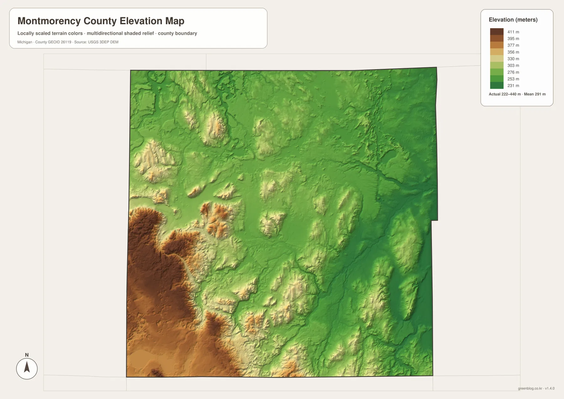
The legend shows an actual elevation range of roughly 222 to 440 meters, with a mean near 291 meters. Montmorency County is not a mountain county, yet that range is large enough to create a clear visual contrast between the higher inland hills and the lower river corridors. Comparing the elevation image with the water map makes the relationship easier to see: the major eastern river branches occupy lower ground, while higher ridges rise between and west of them.
This elevation image is useful for county-scale comparison, but it is not survey data for an individual parcel. It should not be used to determine a building elevation, road grade, drainage design, or site-specific flood exposure. Projects that depend on precise height measurements should use surveyed information or the underlying USGS 3D Elevation Program data appropriate to the task.
Forests and elk are part of the Atlanta-area identity
The wide spaces between communities are not simply blank areas on the map. Montmorency County’s own materials describe the county as heavily forested, with older local information commonly citing forest cover of about 86 percent. That description matches the overall character visible in the map set: the developed places are relatively small, while wooded land, waterways, and rural roads dominate the spaces between Atlanta, Hillman, Lewiston, and the county boundaries.
Atlanta is also strongly associated with Michigan’s elk range. Michigan DNR identifies portions of Montmorency County, along with southern Cheboygan and Otsego counties, as part of the core range for the state’s free-ranging elk herd. The Atlanta Chamber of Commerce promotes the community as the “Elk Capital of Michigan.” These maps do not show live elk locations, but they are useful for understanding the location of Atlanta and the surrounding forest before consulting DNR’s current viewing guidance and access information.
Rainy River Flooding and other named water and forest areas also reflect the county’s outdoor character. Anyone planning a trip should still check current rules for state-managed land, seasonal road conditions, private-property boundaries, and wildlife areas. A county reference map can show where a road or stream lies, but it cannot tell whether a seasonal route is currently passable or whether a particular parcel is open to public access.
Choose the map that matches the question
For a general county overview, the base map is the most useful single image because it combines communities, roads, county boundaries, and nearby counties. It works well when the question is where Atlanta, Hillman, and Lewiston are located or how M-32 and M-33 fit into the county. The city-index map is much more focused; it is best when Hillman itself needs to be highlighted without the full set of settlement labels.
For rivers, tributaries, and lakes, the terrain and water map is the clearer choice. It makes the separation between the Thunder Bay River branches and the Black River system easy to see and labels several lakes that are less prominent on the road-oriented image. The elevation map is better for explaining why the southwest looks different from the eastern river country, because the color scale emphasizes the difference between higher hills and lower valleys.
The downloadable archive contains A3 landscape JPG versions of the county map, city-index map, terrain-and-water map, and elevation map. Each source image is 3638 × 2572 pixels, giving enough resolution for classroom work, presentations, and many print uses. You can use a full map as a regional reference or crop a portion when the topic is one road, river, or community. For legal boundaries, emergency routing, flood hazards, land ownership, or engineering decisions, use the responsible agency’s current official map in addition to this general-reference set.
Frequently Asked Questions
Which map should I use to see Atlanta, Hillman, and Lewiston together?
Use the general county map. It labels Atlanta near the center, Hillman close to the eastern boundary, and Lewiston in the southwest while also showing M-32 and M-33. The city-index image highlights only Hillman, so it is not intended to be a complete settlement map.
Can the Thunder Bay River and Black River systems be compared on one map?
Yes. The terrain and water map shows Thunder Bay River, North Branch Thunder Bay River, and Upper South Branch Thunder Bay River together with Black River and East Branch Black River. It also labels several lakes and smaller streams, making it the best image in this set for comparing waterways across the county.
What is the main terrain difference visible on the elevation map?
The southwest and parts of the west are generally higher, while the eastern side contains lower river valleys. The legend indicates an overall range of about 222 to 440 meters. The map is appropriate for regional terrain comparison, not for parcel-level elevation or engineering measurements.
Map File Information
Download the A3 high-resolution JPG versions of the Montmorency County maps shown on this page in one ZIP file.
- Included Files: County map, city map, water map, elevation map
- File Type: ZIP containing 4 JPG files
Related Maps
Sources and references
- Montmorency County official website — county background and local geographic information
- Atlanta Chamber of Commerce — Atlanta, outdoor recreation, and local elk information
- Michigan DNR – Elk Viewing — Michigan elk range and viewing guidance
- Michigan DNR – State Game/Wildlife Areas — state-managed wildlife areas
- U.S. Census Bureau – TIGER/Line Shapefiles — county boundaries and road geography
- USGS National Hydrography and USGS 3D Elevation Program — hydrography and elevation reference data
Green Map creates custom-edited map images using open geographic data sources such as geoBoundaries, Natural Earth, OpenStreetMap, and government open data. These maps are edited visual materials, not raw data files, and are provided for education, documents, presentations, and graphic reference.