Montcalm County sits in the west-central part of Michigan’s Lower Peninsula, where a group of small cities and rural communities are linked by state highways, the Flat River, scattered inland lakes, and gently rolling terrain. Greenville anchors the southwest, Stanton occupies a central position as the county seat, Edmore and Lakeview serve the northern part of the county, and Howard City lies close to US-131 on the west. This page uses the supplied county, city, water, and elevation maps to explain those relationships in practical terms. High-resolution JPG versions of the same maps are also available in one downloadable ZIP for printing, classroom work, reports, and presentations.
The county boundary has a stepped shape rather than a simple rectangle, with the southwestern section set farther east than the upper western edge. That outline matters when comparing Greenville with Howard City or when following roads toward Kent, Newaygo, Ionia, and Clinton counties. The northern half also appears more strongly rolling on the elevation map, while lower green terrain becomes more common toward the southeast. Looking at the road, water, and relief maps together makes Montcalm County much easier to understand than relying on a single state-scale map.
Table of Contents
Placing Greenville and Stanton within Montcalm County
Montcalm County is bordered by Mecosta County to the north, Isabella County to the northeast, Gratiot County to the east, Clinton County to the southeast, Ionia County to the south, Kent County to the southwest, and Newaygo County to the west. In broader Michigan geography, the county occupies an inland position northeast of Grand Rapids and northwest of Lansing. Unlike a Great Lakes shoreline county, there is no single water body that defines its edge. Instead, small cities, farms, forested areas, lakes, rivers, and state highways create a network of local centers.
Stanton is the administrative reference point near the middle of the county. An official Montcalm County financial report notes that the county was incorporated in 1850 and identifies the City of Stanton as the county seat. M-66 passes through Stanton and continues south toward Sheridan and Carson City, while the same corridor connects northward toward McBride and Edmore. Greenville, farther southwest, is the most visually prominent urban area on the overview map and sits where M-57 and M-91 provide convenient reference lines for orientation.
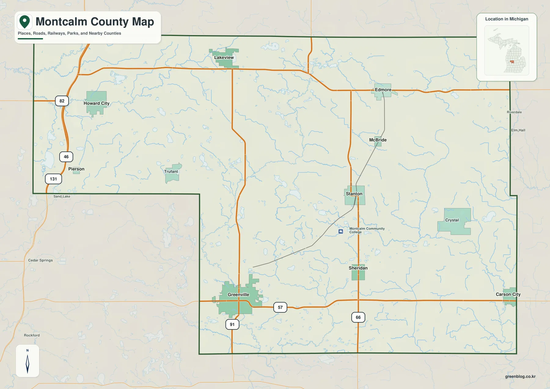
Greenville appears in the southwest, Stanton near the center, Edmore in the northeast, and Howard City in the northwestern part of the county. Lakeview sits across the northern tier, while Carson City is close to the southeastern edge. Smaller communities such as Sheridan, McBride, Crystal, Pierson, and Trufant help fill in the spaces between those better-known centers. The pattern makes it clear that Montcalm County is not organized around one dominant downtown. Different parts of the county connect to different roads and neighboring counties, which is important when planning travel or explaining local geography.
A useful way to learn the map is to locate Greenville and Stanton first, then add Edmore, Howard City, Lakeview, and Carson City. Greenville is easy to find by M-57 and M-91, while Stanton is strongly associated with M-66. From those two anchors, the remaining communities fall into place without requiring the reader to memorize every township or local road. This approach also works well in a classroom or presentation because it gives the audience a small set of recognizable reference points before introducing more detailed water and terrain information.
How M-57, M-66, M-91, and US-131 organize travel
M-57 is one of the clearest east-west routes across the southern part of Montcalm County. It passes through Greenville and continues toward the eastern side of the county, making it a practical line for comparing southwestern and southeastern communities. M-91 runs north from Greenville, while M-66 passes through Stanton and Sheridan on a separate north-south alignment. Because those roads do not all converge at one central interchange, travel within the county often depends on which local center is the starting point.
US-131 runs close to the western side of the county and is especially important for Howard City and Pierson. It provides a fast north-south connection toward the Grand Rapids area and farther north through the Lower Peninsula. M-82 meets the US-131 area near Howard City, giving the northwestern corner another recognizable route. Across the northern tier, M-46 provides an east-west connection through the Lakeview and Edmore area. Together, these highways form a useful framework for reading the county before turning to smaller local roads.
The overview also shows portions of the rail network, including lines around Stanton, McBride, and Edmore. Those lines add context to the county’s transportation geography even when the main purpose of the map is road orientation. The map should not be treated as a live navigation service, however. Construction, closures, route restrictions, and travel times can change. For an actual trip, use current transportation information and navigation tools, while using this map to understand the larger arrangement of communities and corridors.
A distributed group of cities rather than one single center
The city map highlights Greenville, Howard City, Edmore, Stanton, Carson City, and Lakeview with numbered markers. The numbers are best understood as a visual index for locating the communities, not as a travel sequence or administrative ranking. Greenville forms the largest urban area shown in the southwest, while Stanton occupies the central administrative position. Edmore and Lakeview help define the northern half, Howard City ties the west to US-131, and Carson City marks the southeastern side near the Clinton and Gratiot county directions.
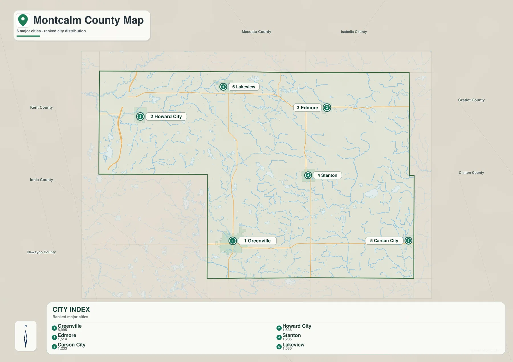
The contrast between Greenville and Stanton is particularly useful. Stanton is the county seat, but Greenville is a larger commercial and transportation center. The two communities are connected through the southern and central road network rather than occupying one continuous urban area. Between them are rural landscapes, smaller settlements, and the Sidney area near Montcalm Community College. That separation is typical of a largely rural Michigan county where public services, shopping, schools, recreation, and employment are spread among several communities instead of concentrated in one metropolitan core.
For a report, it can be helpful to explain each city in relation to a neighboring county as well as to Stanton. Howard City sits closer to the Newaygo and Kent directions, Edmore is closer to the Isabella and Gratiot sides, and Carson City lies toward Clinton and Ionia counties. Lakeview occupies the north-central area, while Greenville remains the key southwestern reference point. This method shows how Montcalm County participates in several surrounding regional networks rather than pointing only inward toward the county seat.
Flat River, inland lakes, and a dense network of smaller streams
The Flat River is one of the most important natural features for understanding Montcalm County. On the water map it passes through the central and southwestern part of the county and is closely associated with the Greenville area. The northwestern corner contains the Little Muskegon River and Handy Creek, while Tamarack Creek and Tamarack Lake appear across the northern section. To the east, the Pine River and Fish Creek stand out, and smaller waterways such as Dickerson Creek and Prairie Creek add detail to the central and southern drainage network.
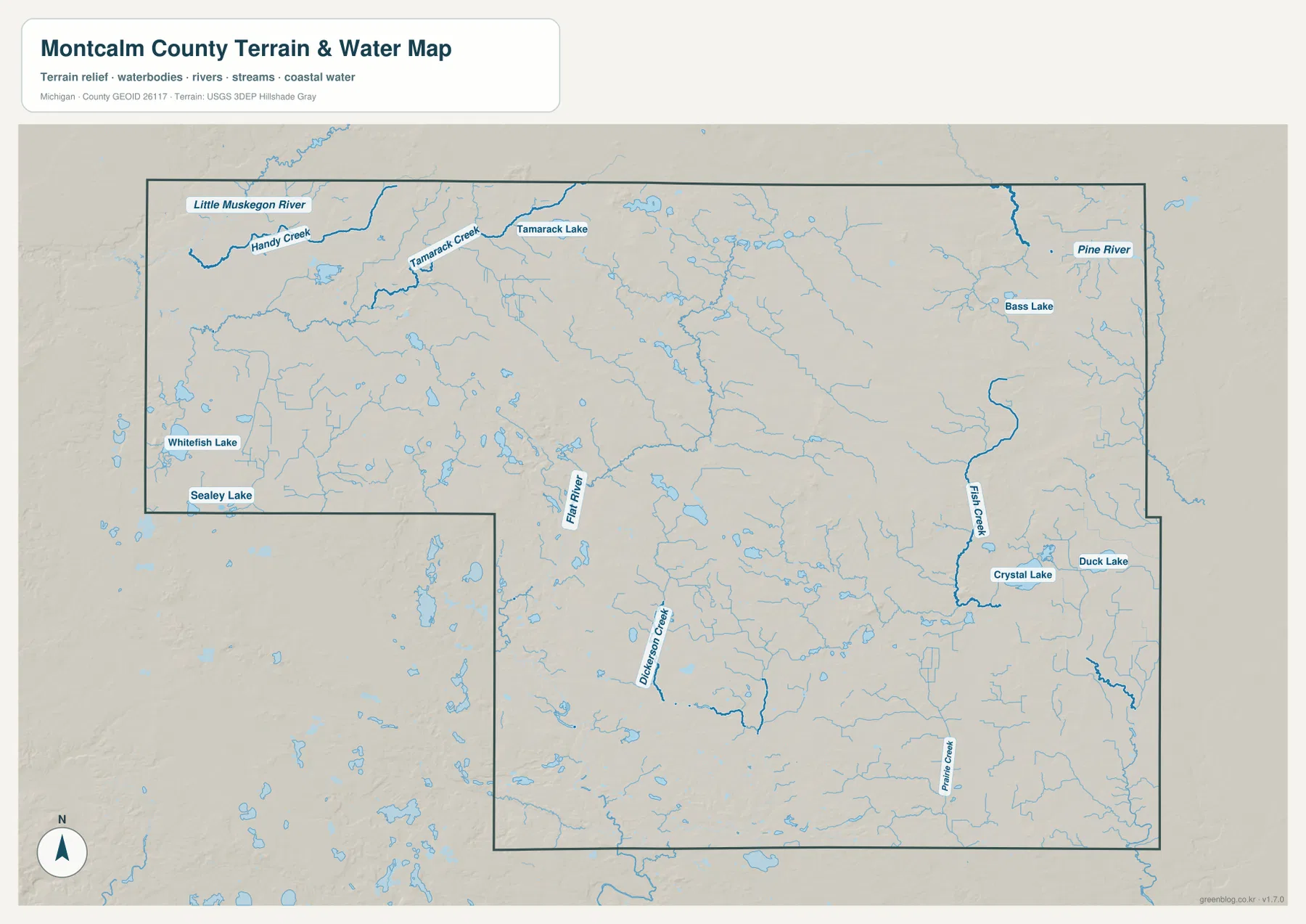
Montcalm County also contains many small lakes rather than one dominant inland lake. Whitefish Lake and Seeley Lake are labeled in the western section, Tamarack Lake appears in the north, Bass Lake is shown in the northeast, and Crystal Lake and Duck Lake are located farther east. The map therefore presents a landscape where rivers, creeks, ponds, and lakes are distributed across the county. This helps explain why outdoor recreation is spread among several communities instead of being focused around one shoreline destination.
The county’s own parks information reinforces that relationship between water and recreation. McCarthy Park north of Greenville has frontage on the Flat River, and Carl Paepke Flat River Nature Park also provides riverfront trails. Krampe Park near Howard City is associated with Winfield Lake, while Schmeid Park and Camp Ford Lincoln near Lakeview are tied to Towline Lake. These locations are not substitutes for a detailed recreation map, but they provide useful local context for understanding why rivers and lakes matter to residents and visitors.
This water image is a county-scale reference rather than a flood, boating, depth, or parcel map. It can show where named rivers, creeks, and lakes sit in relation to one another, but it should not be used to determine flood risk, legal access, water depth, shoreline ownership, or current water quality. Those questions require the appropriate official datasets. For general geography, classroom use, and regional orientation, however, the map makes the county’s water network much easier to see than a road-focused map alone.
Higher northern uplands and lower terrain toward the southeast
The elevation map reveals a stronger terrain contrast than the road map suggests. Brown and tan shades dominate much of the northern and northeastern half, indicating higher rolling ground, while green shades become more widespread toward the south and especially the southeast. The map legend notes an actual elevation range of roughly 211 to 337 meters, with a mean near 270 meters. Montcalm County is not mountainous, but the difference is large enough to create visible ridges, low areas, and drainage routes across the landscape.
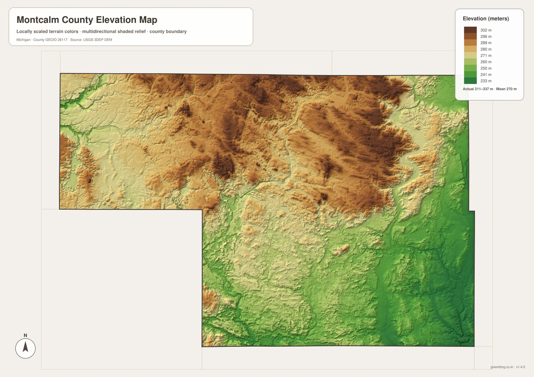
Comparing the elevation and water maps helps explain the county more clearly. Small streams begin within and between higher areas, then follow lower ground toward larger channels. The Flat River occupies part of that lower network through the central and southwestern county, while Fish Creek and Pine River relate to the eastern side. Because the relief is rolling rather than dramatic, the differences can be difficult to recognize from ordinary road lines. Shaded terrain makes those subtle changes visible without requiring a technical contour map.
Greenville and Stanton sit within intermediate terrain compared with the higher northern uplands and lower southeastern areas. The western side also contains a mixture of gentle ridges and lower surfaces rather than one continuous slope. That variation is useful when explaining why roads, creeks, and settlement patterns do not follow a perfectly regular grid. It also makes the county visually different from very flat agricultural counties farther south and from the more rugged northern parts of Michigan.
The shaded surface is intended for regional comparison, not property-level decisions. Precise site elevation, drainage design, construction, flood analysis, and parcel questions require survey-grade or authoritative project data. For general geographic explanation, the map is valuable because it shows where the county becomes higher or lower and allows those landforms to be compared with cities and waterways on the other maps.
Parks and trails add practical visitor context
Visitors looking beyond the road network can use the county’s parks and trails as additional geographic reference points. Montcalm County lists McCarthy Park and Carl Paepke Flat River Nature Park along the Flat River, Krampe Park near Howard City and Winfield Lake, and lake-oriented facilities near Lakeview. These sites show how recreation is distributed across the same water-rich landscape visible on the hydrography map. Picnic areas, walking trails, boat access, and overnight facilities differ by park, so the county’s current information should be checked before a trip.
Trail connections are also useful for understanding the county at a human scale. Michigan DNR information for the Fred Meijer White Pine Trail State Park describes a long north-south route that passes through communities including Howard City. The Fred Meijer Heartland Trail is associated with the Greenville-Stanton-Edmore corridor, while Greenville also has local Flat River trails that connect parks and riverfront areas. These nonmotorized routes provide a different perspective from state highways because they link towns through former rail corridors, natural areas, and local recreation spaces.
A map page should still separate geographic orientation from current visitor logistics. Park hours, reservations, trail surfaces, closures, and construction can change by season and year. Use the county map to decide which part of Montcalm County you are interested in, then check the official county or Michigan DNR page for the latest operating information. This keeps the map useful as a stable reference while avoiding the mistake of treating it as a live tourism schedule.
Choosing the right Montcalm County map for a project
The county overview is the best starting point when roads, communities, boundaries, and general orientation all matter. It works well for a report introducing Montcalm County, a classroom worksheet about west-central Michigan, or a presentation that needs to place Greenville and Stanton in relation to the surrounding counties. Because recognizable highways and community labels are already included, the overview usually needs less annotation than the more specialized maps.
The city map is clearer when the main question is where major communities sit relative to one another. The water map should be used for the Flat River, Little Muskegon River, Pine River, Fish Creek, and inland lakes, while the elevation map is the best choice for comparing the higher northern terrain with the lower southeast. Selecting the specialized map that matches the topic keeps a printed page or slide easier to read and avoids crowding too many layers into one graphic.
The downloadable JPG files are prepared at 3638 × 2572 pixels for A3 landscape use. They can be printed directly, inserted into a report, or cropped to focus on one town, river, or section of terrain. A useful teaching sequence is to begin with the overview, compare the six-city distribution, move to rivers and lakes, and finish with relief. That order takes the reader from familiar human features to the natural geography underneath them.
Frequently Asked Questions
Which places are the best starting points for reading a Montcalm County map?
Start with Greenville in the southwest and Stanton near the center. Greenville is easy to locate where M-57 and M-91 meet, while Stanton sits on M-66 and serves as the county seat. Once those two anchors are in place, add Lakeview and Edmore to the north, Howard City near US-131 to the west, and Carson City toward the southeast. This is faster than trying to memorize every small community at once.
Which map is best for the Flat River and Montcalm County lakes?
The water map is the clearest choice. It highlights the Flat River, Little Muskegon River, Pine River, Fish Creek, Tamarack Creek, and several named lakes such as Whitefish Lake, Tamarack Lake, Crystal Lake, and Duck Lake. If you also need to explain nearby cities or highways, pair the water map with the county overview rather than trying to add every road to the hydrography image.
Can the elevation map be used for flood, engineering, or property decisions?
No. The elevation image is a county-scale reference for comparing broad terrain differences, especially the higher northern uplands and lower southeastern areas. It is not a substitute for a property survey, engineering-grade elevation model, flood insurance map, or parcel record. Use the map for geographic context, then consult the appropriate official source when a decision depends on exact elevation, ownership, drainage, or flood risk.
Map File Information
Download the high-resolution JPG versions of the Montcalm County maps shown on this page in one ZIP archive.
- Included Files: county map, city map, water map, and elevation map
- File Type: ZIP containing four JPG images
Related Maps
Sources and references
- Montcalm County – 2021 Audit for incorporation and county-seat context
- Montcalm County – Parks for county parks along the Flat River and local lakes
- Michigan DNR – Fred Meijer White Pine Trail State Park for the state trail corridor through Howard City
- U.S. Census Bureau – TIGER/Line Shapefiles for county and transportation boundary reference
- U.S. Geological Survey – National Hydrography for rivers and water features
- U.S. Geological Survey – 3D Elevation Program for elevation reference
Green Map creates custom-edited map images using open geographic data sources such as geoBoundaries, Natural Earth, OpenStreetMap, and government open data. These maps are edited visual materials, not raw data files, and are provided for education, documents, presentations, and graphic reference.