Henderson County occupies a distinctive stretch of western Kentucky where broad bends of the Ohio River shape the northern and western edge of the county. Henderson is the dominant riverfront city, while Corydon and Robards sit farther south in the interior. The maps on this page combine county boundaries, roads, the main settlement points, named waterways, and an actual elevation range of about 104 to 176 meters. High-resolution JPG versions are available in the ZIP download below.
The county is easiest to orient by finding Henderson and the Ohio River first. The river swings around the northern side of the city and creates another large loop along the western part of the county. South of Henderson, road corridors become more useful than the river for locating Corydon, Robards, Anthoston, and the rural interior. Comparing the road map with the water and elevation layers shows why the river margins look broad and low while the interior is broken into modest ridges and creek valleys.
Table of Contents
Henderson anchors the county just south of a major Ohio River bend
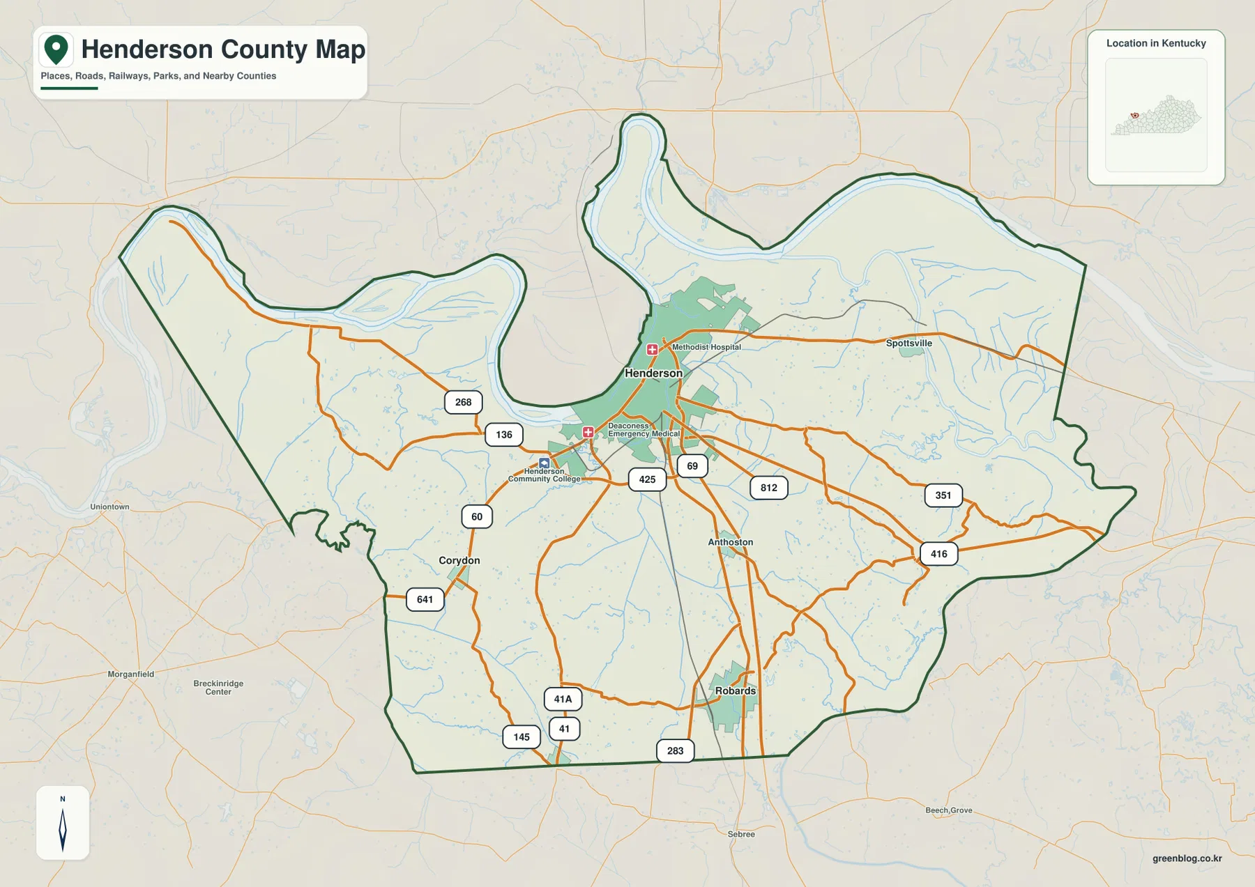
Henderson is the strongest reference point on the general county map. The built-up area sits directly below the Ohio River, and labels for Deaconess Henderson Hospital and Henderson Community College reinforce the concentration of activity around the city. U.S. 60, the U.S. 41 corridor, KY 136, KY 268, KY 425, and KY 812 provide clear road references around the urban area and connect it with the rest of the county.
Spotsville appears east of Henderson, while Anthoston and Robards are farther south and southeast. Corydon lies southwest of the city near U.S. 60 and U.S. 641. The county boundary is unusually easy to recognize because the Ohio River creates wide outward bulges on the west and north. Rather than thinking of Henderson County as a simple rectangle, it is more accurate to picture a riverfront city near the top with two large river bends wrapped around a broader interior.
Corydon and Robards split the southern interior into two useful reference areas
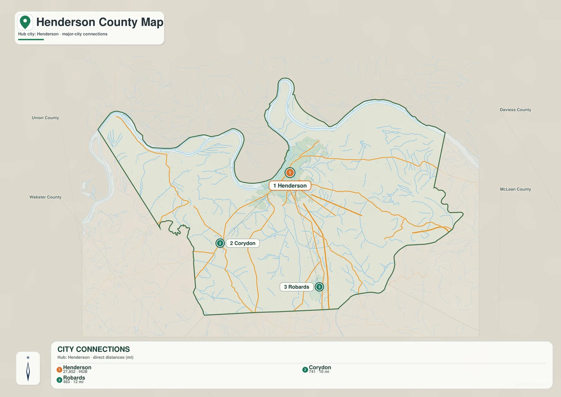
The city-connections map uses Henderson as the hub and highlights Corydon and Robards as the other principal city points. It shows Corydon at about 10 miles from Henderson and Robards at about 12 miles. These are straight-line distances between mapped points, not driving distances, so actual road mileage depends on the route and the exact starting location within each community.
Corydon lies southwest of Henderson and is easiest to place with U.S. 60 and U.S. 641 nearby. Robards is southeast of Henderson and closer to the north-south U.S. 41 corridor. Their positions show that the county’s main settlement pattern is not a single straight chain: Henderson occupies the riverfront, while the two smaller centers branch into different parts of the southern interior.
The simplified city map removes many smaller roads and facility labels, which makes the three-place geometry clearer. Once that layout is familiar, the detailed county map can be used to add U.S. 60, U.S. 41, U.S. 641, KY 283, KY 145, and other local roads. This two-step approach is particularly useful when explaining the county to someone who does not already know western Kentucky.
The Ohio and Green rivers frame a county filled with sloughs, creeks, and ponds
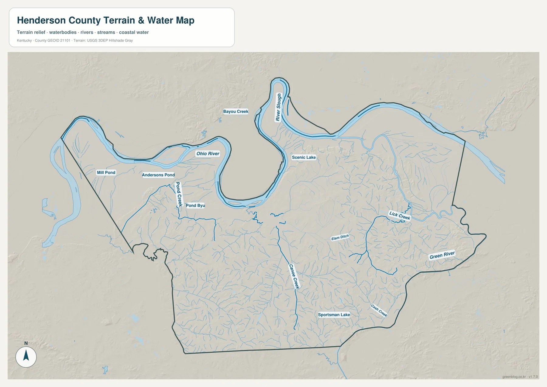
The terrain-and-water map is dominated by the Ohio River along the north and west. Near Henderson, River Slough occupies the inside of the large northern bend, with Bayou Creek and Scenic Lake nearby. Farther west, Mill Pond, Andersons Pond, and Pond Creek mark a low-water landscape inside the broad riverfront section of the county.
The Green River appears along the eastern and southeastern edge of the county, with Lick Creek feeding through that side of the map. Canoe Creek runs through the south-central interior, while Elam Ditch, Cash Creek, and Sportsman Lake provide additional local references. Together these waterways show that the space between the two large rivers is not uniformly flat; it is divided by a dense network of smaller drainage corridors and low areas.
Henderson County’s official site provides local government context, while Kentucky State Parks describes the wetlands and floodplain forest associated with John James Audubon State Park in Henderson. Those references fit the river-and-wetland character visible on the supplied map. The map itself is a static geographic reference, however, and should not be used as a flood-hazard map, live river-stage source, navigation chart, or legal parcel product.
A 104–176 m elevation range separates broad river lowlands from gentle interior ridges
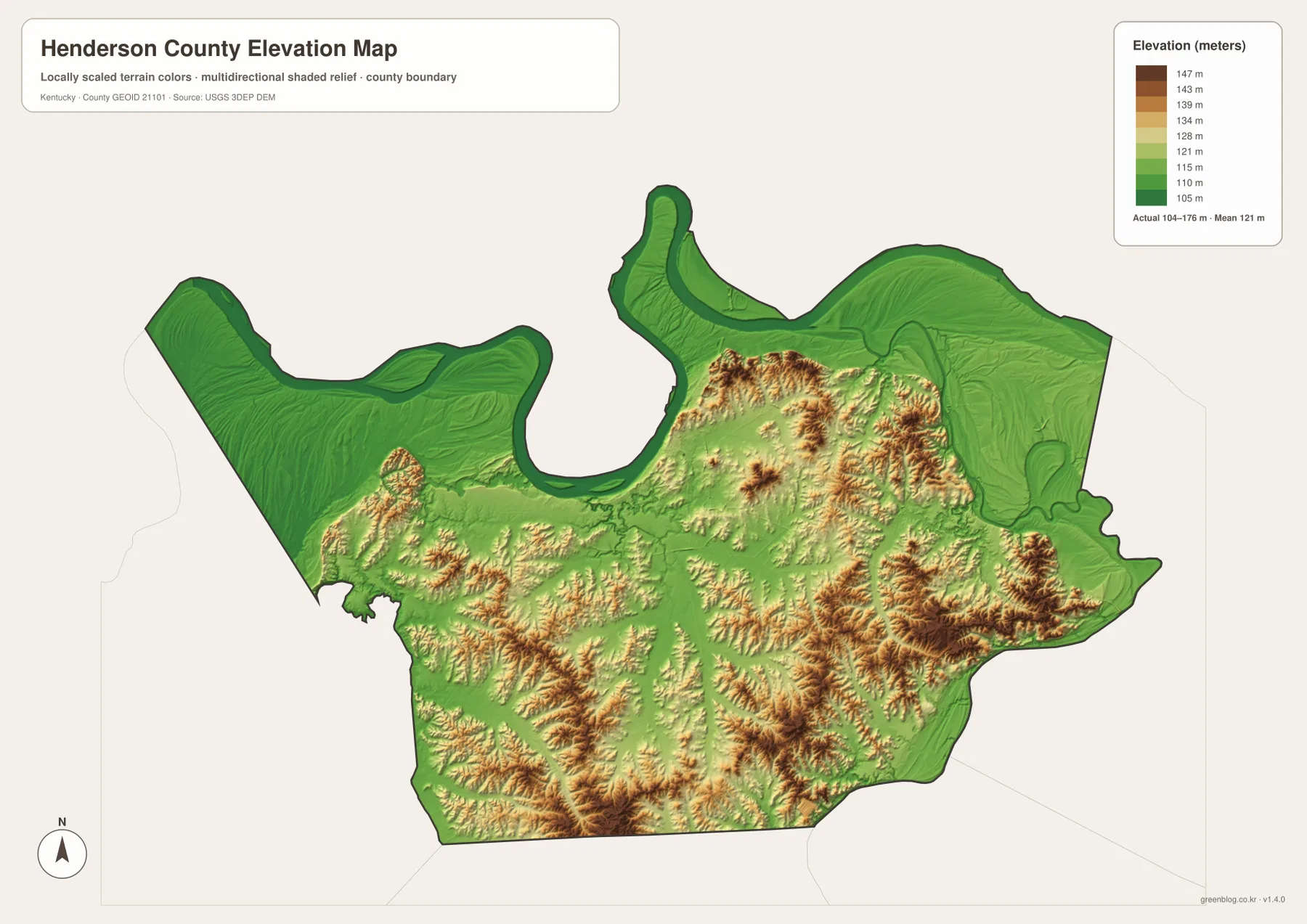
The elevation map reports an actual range of about 104 to 176 meters, with a mean of 121 meters. That is a relatively modest range compared with eastern Kentucky mountain counties, but the color pattern still makes the major landform difference easy to recognize. The broadest low green areas follow the Ohio River, especially the northern bend and western riverfront, while somewhat higher terrain becomes more common toward the interior.
Low ground also extends along the Green River side of the county and into narrow creek corridors. In contrast, the south-central and southeastern interior contains a tighter pattern of short ridges and shallow valleys. Several of the higher brown and tan areas appear away from the two major rivers, showing how quickly the landscape changes after leaving the floodplain and larger drainage corridors.
This surface is intended for county-scale comparison rather than property-level measurement. It can help explain why the Ohio River bends occupy broad low areas and why Canoe Creek or Lick Creek follows lower ground, but it is not survey-grade elevation data for construction or engineering. For general orientation, the elevation layer works best beside the water map because many low corridors line up with named waterways.
Use the river bends for Henderson and the highway network for the southern towns
For Henderson and the northern part of the county, the general map and water map are the most informative pair. The city sits immediately below the Ohio River bend, so the river outline provides a strong landmark before individual road numbers are considered. U.S. 60 and the U.S. 41 corridor can then be added to connect the riverfront with Spotsville and the inland road network.
For Corydon and Robards, start with the city-connections map to establish their relative positions south of Henderson, then switch to the general map for road detail. Corydon aligns with U.S. 60 and U.S. 641, while Robards is closer to U.S. 41 and the southeastern road network. The elevation map adds another layer of context by showing that these inland routes cross rolling ground rather than a single uninterrupted river plain.
Choose the Henderson County file that matches the geographic question
The general county map is the best choice when boundaries, roads, city labels, and nearby context need to appear together. The city-connections map is cleaner when the main question is how Henderson, Corydon, and Robards relate to one another. Use the terrain-and-water map for the Ohio River, Green River, named creeks, ponds, and sloughs, and use the elevation map when the contrast between river lowlands and the interior ridges matters most.
For printing, classroom work, local presentations, or a larger display, the ZIP below contains the original high-resolution JPG versions. Because the four files emphasize different information, pairing the road map with the water map or the water map with the elevation layer often gives a clearer picture than relying on one map alone.
Frequently Asked Questions
Where is Henderson on the county map?
Henderson is in the north-central part of the county immediately south of the Ohio River. The large river bend above the city and the U.S. 60/U.S. 41 road network make it the easiest place to identify on the general map.
Are the 10-mile and 12-mile city connections driving distances?
No. The city-connections map shows straight-line distances from Henderson: about 10 miles to Corydon and about 12 miles to Robards. Driving mileage can be longer and should be checked with current road or navigation information.
Where is the lowest terrain in Henderson County?
The lowest colors on the elevation map are concentrated along the Ohio River and other major lowland corridors, including parts of the Green River side. The map reports an actual range of about 104–176 meters and a mean of 121 meters, with somewhat higher rolling terrain across much of the interior.
Map File Information
Download high-resolution JPG versions of the Henderson County general map, city-connections map, terrain-and-water map, and elevation map.
- Included Files: county map, city map, terrain-and-water map, elevation map
Related Maps
Sources and References
Local government and community information is available from the Henderson County official website and the City of Henderson official website. Natural and wetland context near Henderson can be checked through the Kentucky State Parks page for John James Audubon State Park.
Administrative boundaries can be checked with U.S. Census Bureau TIGER/Line, waterways with USGS National Hydrography, and elevation data with the USGS 3D Elevation Program. These maps are static reference products and should not replace current legal boundaries, flood information, navigation data, parcel records, or survey and engineering measurements.
Green Map creates custom-edited map images using open geographic data sources such as geoBoundaries, Natural Earth, OpenStreetMap, and government open data. These maps are edited visual materials, not raw data files, and are provided for education, documents, presentations, and graphic reference.