Kalkaska County in northern Michigan is easy to orient around the community of Kalkaska, where M-72, US-131, and M-66 converge before heading toward different parts of the county. Rapid City and South Boardman provide western and southwestern references, while Manistee Lake and Bear Lake help distinguish the eastern half. The road map looks relatively simple, but the water and elevation views reveal a much more varied landscape of rivers, lakes, low valleys, and high ridges. High-resolution map files are available for download in the section below.
This page separates those features into four useful views: a general county map, a ranked-city map, a terrain-and-water map, and an elevation map. High-resolution JPG versions of the same themes can be downloaded in a ZIP file for larger viewing or printing. The descriptions below focus on what can be verified from the supplied maps and distinguish general geographic reference from uses that require current flood data, navigation rules, parcel records, or survey-grade elevations.
Table of Contents
Kalkaska anchors the road network where M-72, US-131, and M-66 meet
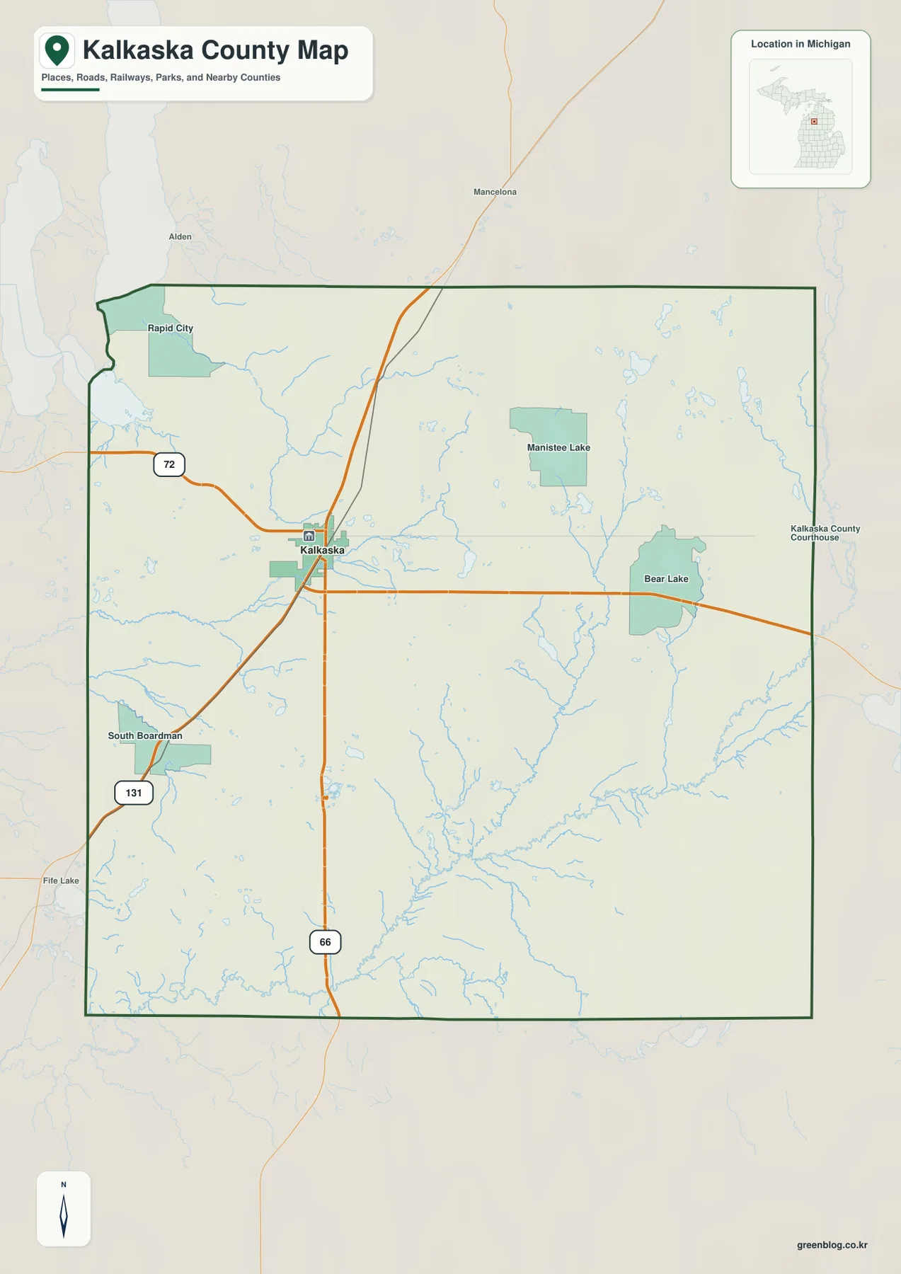
The clearest starting point on the general county map is Kalkaska. It sits slightly west of the county’s center, at a junction where M-72 runs east-west, US-131 approaches from the north and continues toward the southwest, and M-66 extends south. Because several major routes meet in the same area, a reader can use Kalkaska as the main reference before looking for smaller communities, lakes, or rural roads. The county does not have the dense road pattern of a large metropolitan area, so these few highways provide a particularly useful orientation framework.
West of Kalkaska, M-72 leads toward Rapid City, which appears near the northwestern side of the county. US-131 heads southwest toward South Boardman, another useful landmark close to the western edge. Eastward, M-72 reaches the Bear Lake area, while Manistee Lake lies northeast of Kalkaska. The two lake names are separated on the map and should not be treated as one location. Their positions are especially useful when a destination is described by a lake or township name rather than by a major highway.
Several places outside the county boundary also appear as context, including Mancelona to the north, Alden to the northwest, and Fife Lake to the southwest. Those labels help show how Kalkaska County fits among nearby communities even when the destination itself lies beyond the boundary. The map is intended to show relative position and the major road framework. For current construction, closures, legal access, or turn-by-turn routing, travelers should still use current transportation information rather than relying on this static reference map alone.
The ranked-city view identifies Kalkaska as the single indexed major city
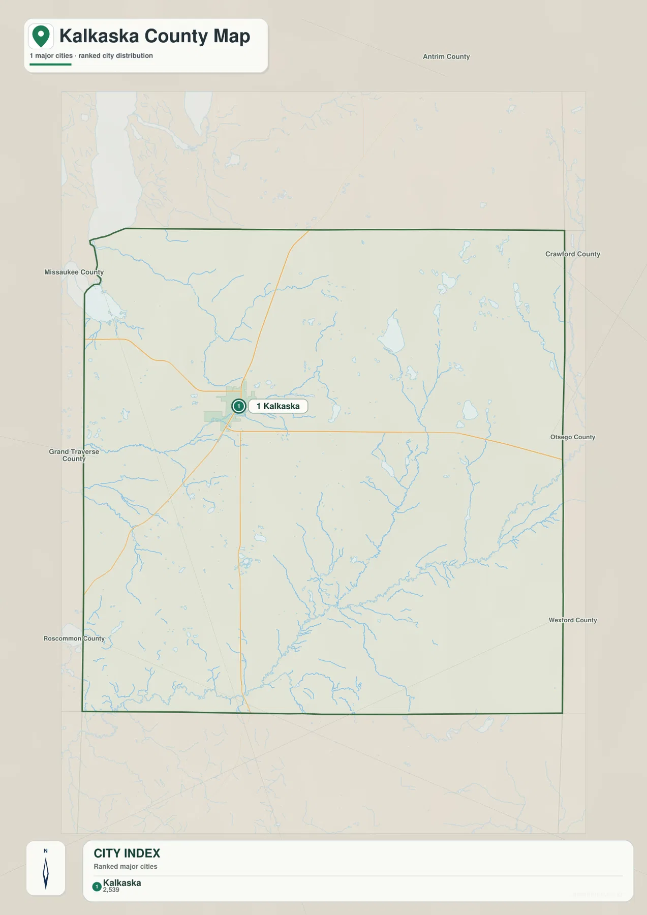
The city distribution map contains one ranked major place: Kalkaska. The comparison value printed in the city index is 2,539. That figure should be understood as the value used to build this map rather than as a current population estimate. Readers who need the latest official population count or estimate should consult current U.S. Census Bureau data. For map-reading purposes, the more important information is Kalkaska’s position within the county and its relationship to the surrounding county boundaries.
Kalkaska lies somewhat west of the county’s midpoint, close to the major road junction seen on the general map. Neighboring county labels provide a second level of orientation: Antrim County is to the north, Crawford and Otsego counties are on the eastern side, Wexford and Roscommon counties are toward the south and southeast, and Grand Traverse and Missaukee counties lie to the west and southwest. This wider frame is useful when following a route that crosses a county line or when comparing Kalkaska’s location with other northern Michigan communities.
Because only one ranked city is shown, the map has no city-to-city connector lines and no straight-line distance comparisons. It should therefore not be interpreted as a distance network. Its role is to locate Kalkaska clearly inside the boundary and show the surrounding county directions. To find Rapid City, South Boardman, Bear Lake, or Manistee Lake, the general county map is the better companion because it includes more settlements and the major highway network.
Rapid River, Boardman headwaters, and the Manistee system divide the county into several water regions
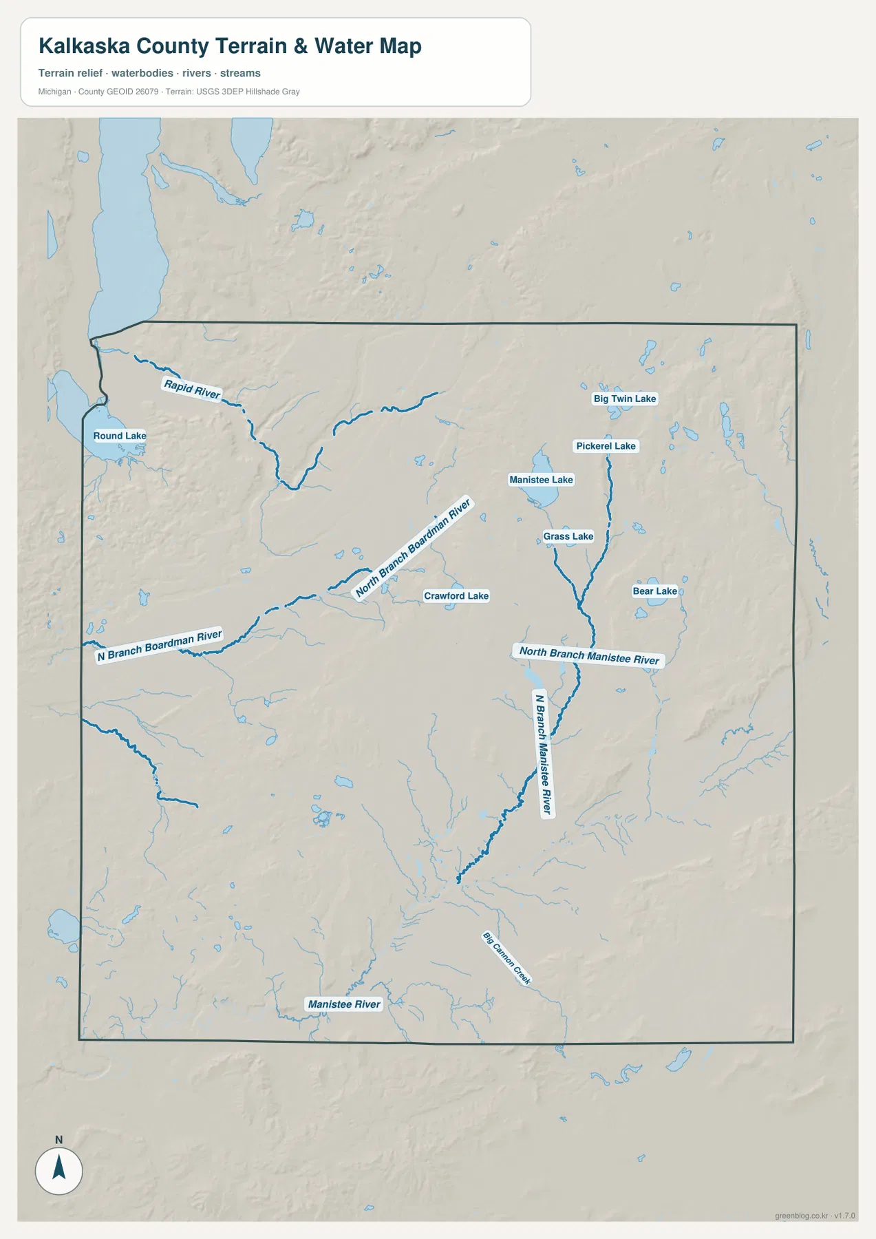
The terrain-and-water map gives the northwest a distinct identity through the Rapid River. The river bends across the low northwestern part of the county, and Round Lake is marked near the western boundary. When the water map is compared with the general road map, the Rapid City side of the county becomes easier to recognize because the river provides a natural landmark in addition to the highway. Numerous smaller tributaries also appear, showing that the northwest is not simply an open plain around one road corridor.
Across the central-western portion, the North Branch Boardman River runs generally from west toward the interior. It has a winding course and receives smaller streams along the way. Crawford Lake is labeled near the center, providing another compact water landmark. The northeastern portion contains a different group of lakes, including Manistee Lake, Grass Lake, Pickerel Lake, and Big Twin Lake. These water bodies are separated from one another across higher terrain rather than forming a single continuous lake basin.
The North Branch Manistee River is the most prominent named drainage in the east-central part of the map. It runs southward between the lake-rich northeast and the broader southern half of the county, eventually connecting with the Manistee River system shown farther south. Bear Lake lies east of the branch, while Grass Lake is farther north. Big Cannon Creek appears in the southeast, adding another reference for a part of the county that has fewer named communities on the general road map.
This water map is intended for geographic orientation, not for flood risk, boating access, fishing regulations, or property rights. Stream levels, navigability, public access, and local rules can change or require more detailed information. Kalkaska County has many named inland lakes, so visitors interested in recreation should check Michigan Department of Natural Resources resources for the specific lake they plan to use. The map is most useful for distinguishing the major river branches and locating the more prominent lakes relative to one another.
An actual elevation range of about 179 to 446 meters separates the low northwest from the high northeast
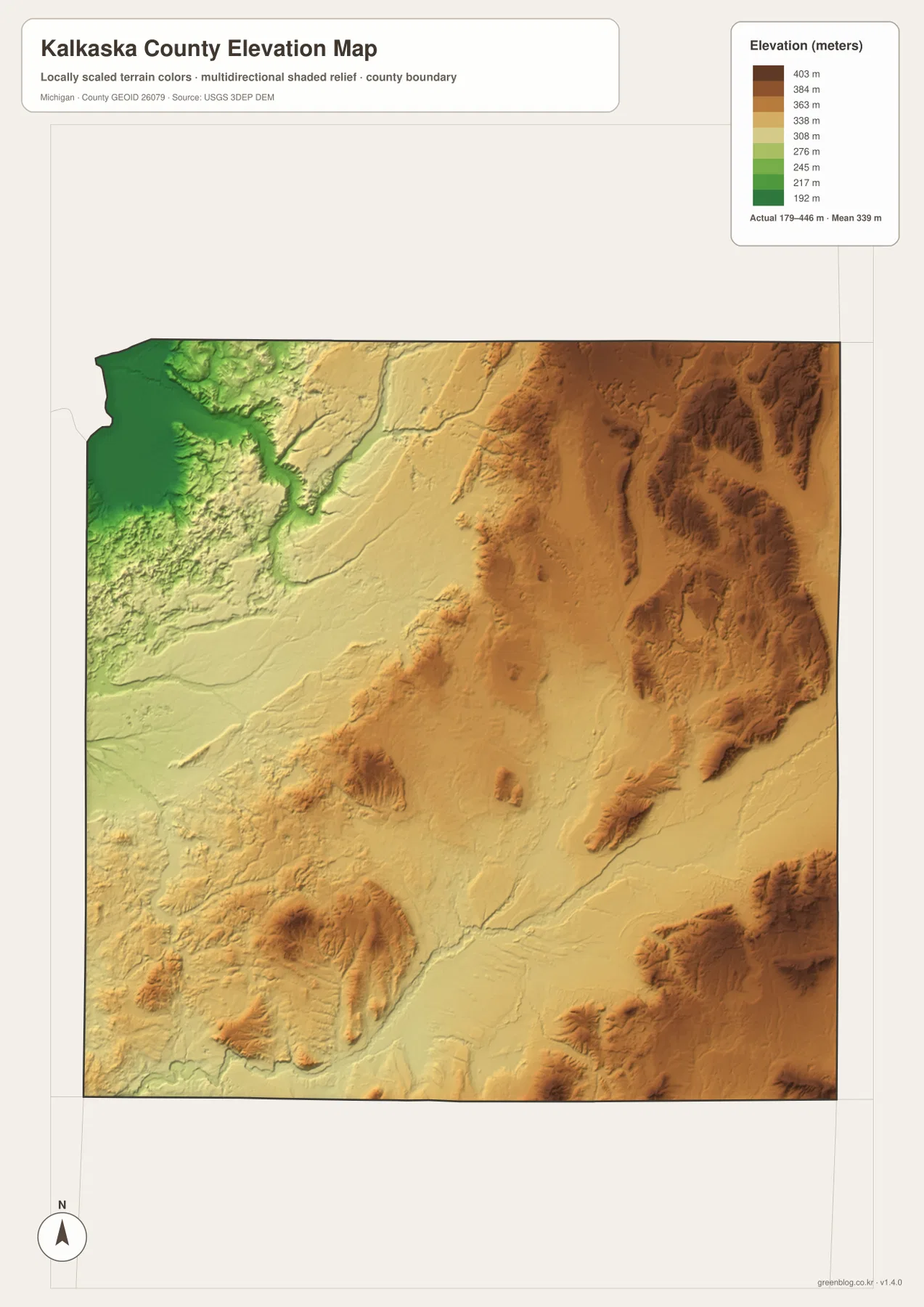
The elevation map states an actual county range of about 179 to 446 meters and a mean elevation of about 339 meters. Green shades represent lower ground, while yellow, tan, and brown represent progressively higher terrain. The strongest contrast is visible across the northern half. The northwest corner is deep green and clearly lower than most of the county, while the northeast and eastern edge rise into broad brown uplands with several elongated ridges.
The low northwestern terrain corresponds broadly with the Rapid River side of the county. Moving east from that area, the colors change from green through pale yellow before reaching the much higher brown terrain of the northeast. The eastern uplands are not one smooth plateau; shaded relief reveals a sequence of ridges and valleys, especially near the eastern boundary. This pattern explains why the county can contain both relatively low river terrain and much higher interior hills within a modest geographic distance.
Southwestern and south-central Kalkaska County are mostly represented by middle-elevation yellows, interrupted by isolated darker hills. The southeast also includes substantial high ground and several strong ridges. Comparing the elevation map with the water map helps show how river branches occupy lower corridors between uplands. The North Branch Manistee River area, for example, runs through terrain where lower valleys sit close to noticeably higher ridges.
The 179- and 446-meter values summarize the actual range shown for the county as a whole. They are not measurements for a specific road, parcel, building, or trail point, and the shaded relief should not be treated as engineering-grade slope data. Construction, drainage design, detailed grading, or other precision work requires original USGS elevation data or professional surveying. For general geographic understanding, the map is well suited to comparing the low northwest with the high northeast and the mixed uplands farther south.
Combining roads, rivers, lakes, and relief makes rural locations easier to narrow down
For a road or address search, begin with the general county map. Find Kalkaska first, then use M-72 as the east-west reference, US-131 for the north and southwest, and M-66 for the south. From there, Rapid City, South Boardman, Manistee Lake, and Bear Lake help narrow the destination to a smaller part of the county. If the trip continues beyond the county line, the neighboring-county labels on the ranked-city view provide a useful regional frame.
For a lake or river reference, the terrain-and-water map is more direct. Rapid River identifies the northwest, the North Branch Boardman River identifies much of the central-western drainage, and the North Branch Manistee River provides a strong north-south reference in the east-central area. Manistee Lake, Grass Lake, Pickerel Lake, Big Twin Lake, Bear Lake, and Crawford Lake can then be used to distinguish smaller areas where the road network alone may not provide an obvious landmark.
The elevation view adds useful context when the character of the terrain matters. The green northwest, high brown northeast, and mixed southern uplands show that Kalkaska County is not uniformly flat. After locating a river or lake, checking the elevation map can show whether it lies in a low corridor or near higher ridges. The WebP images in the article are optimized for browser viewing, while the downloadable high-resolution JPG files are better for enlarging small labels or producing a printed reference sheet.
Each view answers a different question. The general map is best for roads and communities, the ranked-city map for Kalkaska’s position and neighboring county directions, the water map for rivers and lakes, and the elevation map for relief. Using two maps together often gives the clearest result. Around Rapid City, for example, the road map establishes the community’s northwest position, the water map adds the Rapid River, and the elevation map shows why that area stands out as one of the county’s lowest zones.
Frequently Asked Questions
Where is Kalkaska within Kalkaska County?
Kalkaska sits slightly west of the county’s center at the junction of M-72, US-131, and M-66. M-72 leads toward Rapid City to the west and the Bear Lake area to the east, while US-131 heads southwest toward South Boardman. Because several major roads meet there, Kalkaska is the easiest starting point for orienting the rest of the county.
Which rivers and lakes stand out on the Kalkaska County water map?
Prominent waterways include Rapid River, North Branch Boardman River, North Branch Manistee River, and the Manistee River. Labeled lakes include Round Lake, Manistee Lake, Crawford Lake, Grass Lake, Pickerel Lake, Big Twin Lake, and Bear Lake. The map is a geographic reference and should not be used by itself for flood, navigation, access, or fishing-regulation decisions.
What is included in the downloadable ZIP?
The ZIP contains four high-resolution JPG files: a general county map, ranked-city map, terrain-and-water map, and elevation map. Each image is 2572×3638 px, making it more suitable than the browser image for close zooming or printing. The elevation view is not survey-grade, and the water view is not a flood or navigation product.
Map File Information
Download the map files associated with this page for reference, printing, and compatible visual projects.
- Included Files: Use only the versions confirmed in the article and supplied images
- File Type: Use the confirmed download contents
- Intended Use: Printing, education, presentations, and map-based projects
Related Maps
Sources and references
Use the following official and public-agency resources for additional information about Kalkaska County and for authoritative boundary, water, and elevation data. The maps on this page are designed for county-scale geographic reference. Legal boundaries, current water conditions, engineering elevations, and other precision uses should be checked against the latest source data from the responsible agency.
- Kalkaska County official website – county government and local services
- Library of Michigan: Kalkaska County Guide – county history and community background
- Michigan DNR Kalkaska County Inland Lake Maps – inland lake reference material
- U.S. Census Bureau TIGER/Line Shapefiles – county boundary and geographic data
- USGS National Hydrography – rivers, streams, lakes, and hydrographic data
- USGS 3D Elevation Program – elevation data
Green Map creates custom-edited map images using open geographic data sources such as geoBoundaries, Natural Earth, OpenStreetMap, and government open data. These maps are edited visual materials, not raw data files, and are provided for education, documents, presentations, and graphic reference.