Vernon Parish in west-central Louisiana is organized around Leesville, New Llano, and the large Fort Johnson North and South areas near the center. Anacoco, Hornbeck, Simpson, Rosepine, and Pitkin are spread across a much broader landscape of hills, creeks, lakes, and rural roads. U.S. 171, LA 28, and LA 117 provide the clearest transportation references around Leesville, while the outer parish is better understood through smaller highways and waterways. The matching high-resolution JPG files for the maps on this page can also be downloaded together in a ZIP. High-resolution map files are available for download in the section below.
Leesville is the parish seat. Louisiana’s official Vernon Parish profile identifies Leesville as the seat, while Vernon Parish Tourism describes the area through its hills, creeks and bayous, prairies, and pinelands. The supplied maps reflect that mix closely: Leesville and Fort Johnson form the most developed central zone, while the north, east, and west contain far more streams, lakes, and open rural land. Starting with Leesville and then placing New Llano, Anacoco, Rosepine, Simpson, and Pitkin provides a simple orientation for the whole parish.
Table of Contents
Leesville and New Llano form the central U.S. 171 settlement corridor
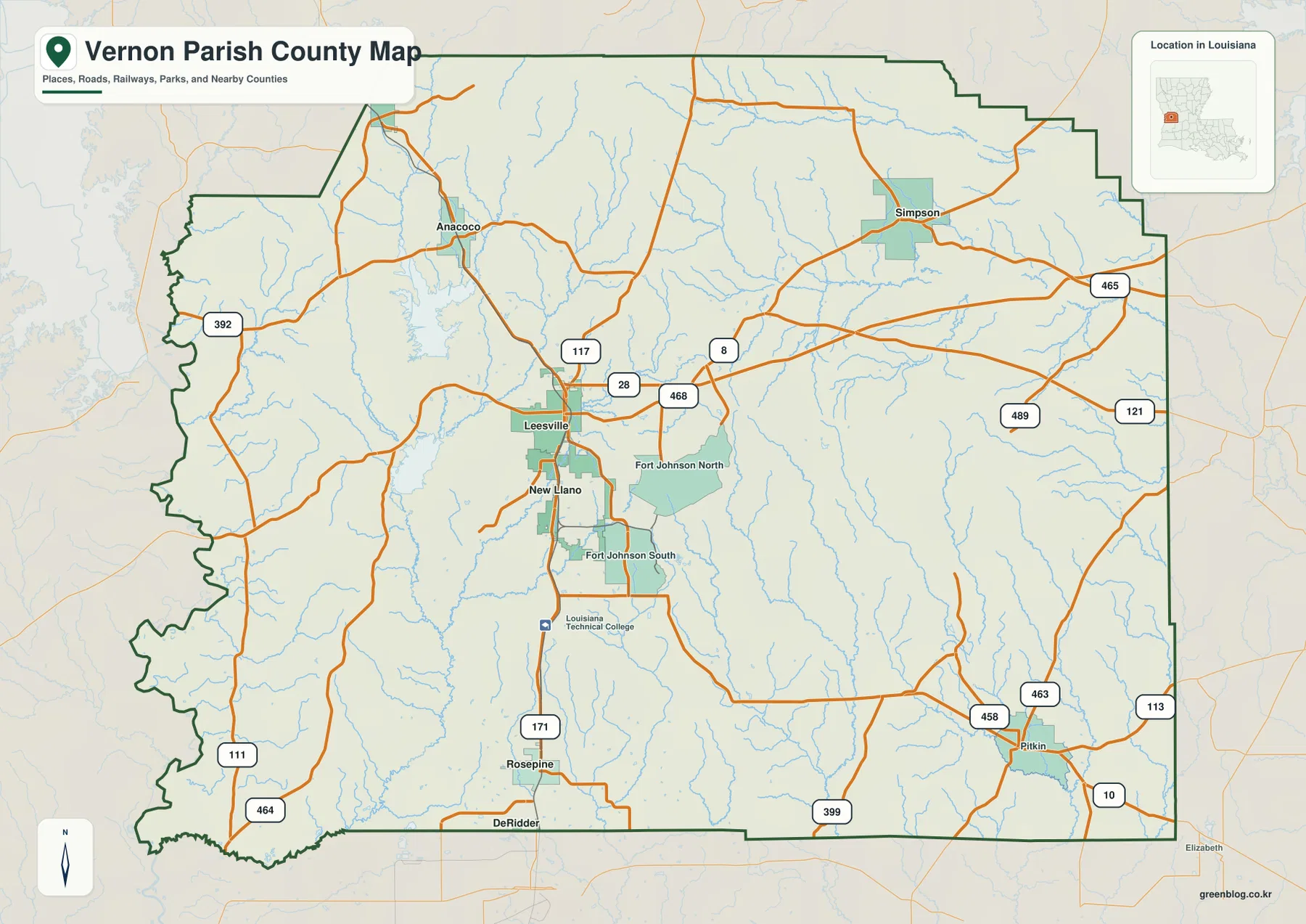
The general map places Leesville in the central-western portion of the parish, with U.S. 171 running north-south through the developed area. LA 28 crosses east-west, and LA 117 approaches from the Anacoco side to the north. Those three routes provide the simplest first framework, while New Llano sits immediately south of Leesville within the same concentrated settlement corridor.
LA 468 and LA 8 extend east of Leesville, and U.S. 171 continues south toward Rosepine and DeRidder. New Llano is closely associated with the nearby Fort Johnson area, so roads and developed land are denser here than in most of the outer parish. Vernon Parish is therefore less a collection of equal-size towns and more a strong Leesville–New Llano center surrounded by smaller communities.
Fort Johnson North and South create a large land reference southeast of Leesville
The supplied map labels Fort Johnson North and Fort Johnson South across a broad area southeast of Leesville. Moving east from New Llano quickly brings the map into the installation area, where roads curve around larger tracts instead of following the tighter street pattern of a small city. The contrast helps explain why the central parish looks much more complex than its rural edges.
LA 468 and LA 8 lead east from the Leesville side toward Simpson, while LA 399 and LA 458–463 help connect the southeast toward Pitkin. Once outside the central developed area, settlements become farther apart and streams become more numerous. Fort Johnson therefore works as more than a place label; it is a major spatial reference separating the Leesville corridor from the broad eastern countryside.
Anacoco and Hornbeck mark the lake-rich northwest
Anacoco lies north of Leesville and is easy to locate from LA 117 and the surrounding local-road network. Vernon Lake and Anacoco Lake appear nearby to the west, while the much larger Toledo Bend Reservoir lies farther toward the Texas side. This combination of a small community and several large water references makes Anacoco especially useful for understanding northwestern Vernon Parish.
Hornbeck appears near the northwestern boundary on the ranked city map, although its developed footprint is small on the detailed county view. LA 392 and the irregular western boundary provide useful orientation nearby, and numerous creeks cross the surrounding countryside. Compared with the Leesville center, the northwest is noticeably less road-dense and much more defined by water and rolling terrain.
Simpson and Pitkin provide eastern anchors across a stream-filled landscape
Simpson sits in the northeastern part of the parish near LA 8 and routes approaching from the north. LA 465 continues across the eastern side, while LA 489, LA 121, and LA 113 help organize the broader rural area farther south and east. Large settlement labels become scarce here, but small streams are abundant.
Pitkin lies near the southeastern edge where LA 10, LA 113, LA 458, and LA 463 meet. Elizabeth appears just beyond the southern boundary and provides wider regional context toward Allen Parish. Using Simpson as a northeast reference and Pitkin as a southeast reference makes the eastern half easier to understand despite its sparse settlement pattern.
The ranked city index compares six selected communities across the parish
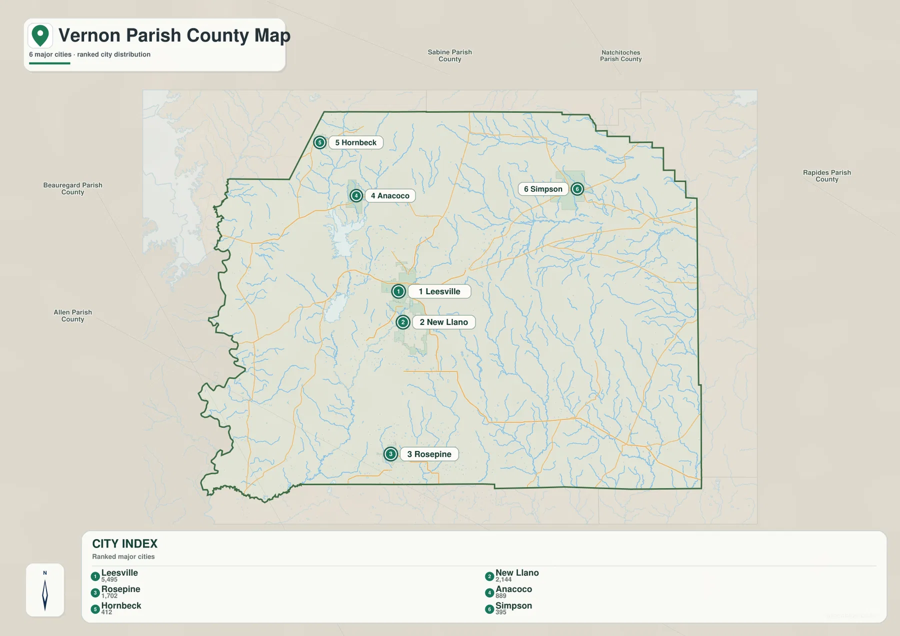
The city-index graphic ranks Leesville number 1, New Llano 2, Rosepine 3, Anacoco 4, Hornbeck 5, and Simpson 6. These numbers are rankings, not straight-line or driving distances from Leesville. Leesville and New Llano are close together near the center, Rosepine lies to the south, Anacoco and Hornbeck are northwest, and Simpson sits to the northeast.
Pitkin is important on the detailed parish map but is not included in the six-place index. The city graphic is therefore best used as a simplified view of selected settlement positions rather than a complete community list. For actual road connections, Fort Johnson, and smaller place labels, the general map provides much more context.
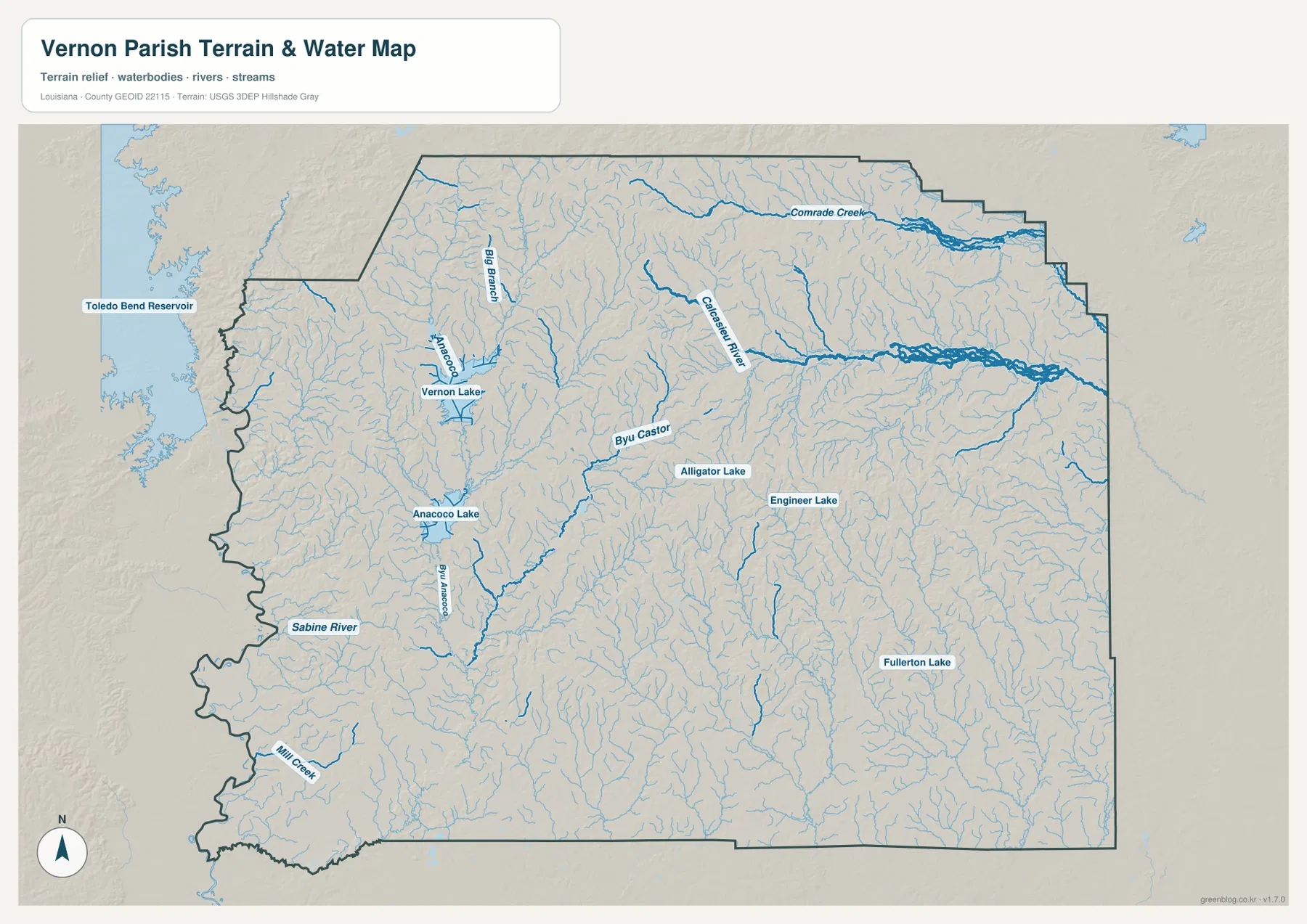
Anacoco Lake and Vernon Lake make the northwestern water pattern easy to recognize
The terrain-and-water map gives the northwest several strong water references. Anacoco Lake and Vernon Lake are both clearly labeled, and Bayou Anacoco extends south from the lake area. Toledo Bend Reservoir appears beyond the western edge, reinforcing the parish’s position close to the Sabine River–Toledo Bend system.
Sabine River appears along the southwestern boundary, with Mill Creek nearby farther south. The boundary bends repeatedly in this area rather than following a simple straight line. Taken together, the lakes, river, and creeks make western Vernon Parish feel very different from the developed Leesville–New Llano corridor.
Calcasieu River and Comrade Creek organize the eastern hills and drainages
Comrade Creek is one of the strongest named channels across the northeast, while Calcasieu River curves through the central-eastern section. Numerous unnamed tributaries branch around both waterways, making the water map much denser than the road view. The pattern also highlights the rolling relief and stream-cut terrain visible across the eastern parish.
Bayou Castor and Alligator Lake appear near the center, Engineer Lake farther east, and Fullerton Lake in the southeast. Big Branch provides another named drainage in the northwest. Vernon Parish Tourism describes the area as a mix of hills, creeks and bayous, prairies, and pinelands, and the supplied terrain-and-water map makes that varied landscape easy to recognize.
Separating the Leesville center from the outer lake-and-stream country simplifies the map
A practical first pass begins with Leesville and New Llano, then uses U.S. 171, LA 28, and LA 117 to establish direction. Add Anacoco to the north, Rosepine to the south, Simpson to the northeast, and Pitkin to the southeast. Fort Johnson North and South occupy a large area just southeast of Leesville and are useful for understanding why the central map is much busier than the outer parish.
For water features, separate Anacoco Lake, Vernon Lake, and Sabine River on the west from Calcasieu River and Comrade Creek on the east. The general map is best for communities and roads, the city index for the six ranked places, and the terrain-and-water map for streams, lakes, and the rolling landscape. The three views together make the contrast between the central settlement corridor and the rural outer parish much clearer.
High-resolution JPG files preserve smaller roads, creeks, and lake labels
The downloadable ZIP contains the original JPG files corresponding to the three previews on this page: the general parish map, the ranked city map, and the terrain-and-water map. Each original image is 3638 by 2572 pixels, providing more room to inspect route numbers, community names, small tributaries, and lake labels than the web preview. The larger format is especially useful around Fort Johnson and the dense stream network across the east.
Choose the general map when Leesville, New Llano, Fort Johnson, and the main roads need to appear together. Use the city index for a quick comparison of the six selected communities. The water map is the better choice for Calcasieu River, Anacoco Lake, Vernon Lake, Sabine River, and the many creeks and smaller lakes. These are general reference maps rather than legal boundary, survey, flood-risk, or real-time navigation products.
Frequently Asked Questions
What is the parish seat of Vernon Parish?
Leesville is the parish seat. Louisiana’s official parish profile identifies Leesville as the seat, and the supplied map also makes it the clearest urban and road center around U.S. 171, LA 28, and LA 117. New Llano and Fort Johnson lie immediately south and southeast.
Do the numbers 1 through 6 on the city map show distance from Leesville?
No. They are rankings for Leesville, New Llano, Rosepine, Anacoco, Hornbeck, and Simpson, not straight-line or driving distances. Actual travel mileage and time should be checked with the general road map and current navigation information.
Can the Calcasieu River and Anacoco Lake map be used for flood or boating decisions?
No. It is a general geographic reference showing Calcasieu River, Sabine River, Anacoco Lake, Vernon Lake, and nearby streams and lakes. It does not provide flood-zone classifications, water depth, navigability, dam or water-control condition, or legal property boundaries.
Map File Information
The ZIP contains the original high-resolution JPG files corresponding to the general parish map, ranked city map, and terrain-and-water map shown on this page.
- Included Files: parish map JPG, ranked city map JPG, terrain-and-water map JPG
Related Maps
Sources and references
For parish-seat information, see the Louisiana.gov Vernon Parish Profile. Local landscape and visitor context are available from the Vernon Parish Tourism Commission. Current road and place context is available from the Louisiana DOTD Vernon Parish Official Map. General boundary data are documented by the U.S. Census Bureau TIGER/Line Shapefiles, and national water-feature data are documented through USGS National Hydrography.
Green Map creates custom-edited map images using open geographic data sources such as geoBoundaries, Natural Earth, OpenStreetMap, and government open data. These maps are edited visual materials, not raw data files, and are provided for education, documents, presentations, and graphic reference.