St. Mary’s County forms the long southern Maryland peninsula between the Patuxent River, Chesapeake Bay, and the Potomac River. Leonardtown anchors the central interior, Charlotte Hall and Mechanicsville mark the north, California and Lexington Park form a busy east-central settlement area, and Callaway, Piney Point, St. George Island, and the Point Lookout direction define the coastal south. Creeks and bays cut deeply into both sides of the county, leaving a landscape of gentle uplands, low shorelines, and narrow peninsulas. This page explains the settlements, roads, waterways, and elevation pattern visible on the supplied maps, and matching high-resolution JPG files are available together in a downloadable ZIP archive.
St. Mary’s County Government is based in Leonardtown, and county planning material identifies Leonardtown as the county seat and the county’s incorporated municipality. The general map also labels large unincorporated communities such as California, Lexington Park, Mechanicsville, and Charlotte Hall, so the administrative map and the everyday settlement pattern are not the same thing. Reading those communities against MD 5, MD 235, the Patuxent River, and the southern coastal waters gives a much clearer view of how the county works.
Table of Contents
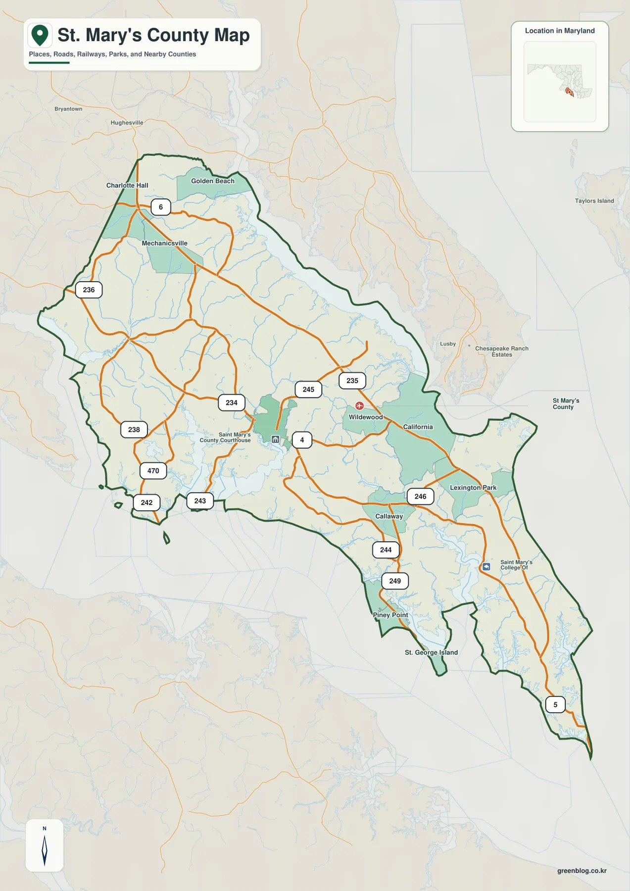
Leonardtown organizes the central road network around MD 5, MD 245, and MD 243
Leonardtown is the clearest central reference on the general map. MD 5 provides the main north-south route, while MD 245 branches toward the northeast and MD 243 reaches toward the southwestern waterfront. The St. Mary’s County Courthouse label appears nearby, reinforcing Leonardtown’s role as the administrative center.
Mechanicsville lies north of Leonardtown, with Charlotte Hall and Golden Beach farther north. MD 5 and MD 235 are the most useful large-road references through this part of the county, while MD 6 crosses near Charlotte Hall. MD 236 and MD 238 help orient the northwestern rural side toward the Charles County boundary.
West of the center, MD 234 reaches toward the Chaptico-St. Clement Bay side, while MD 470 and MD 242 provide additional western coastal connections. This part of the county is characterized less by a continuous city belt than by farms, scattered communities, and numerous creek valleys. The road pattern becomes easier to understand when compared with the water and elevation maps.
Because St. Mary’s County is long and roads branch in several directions, MD 5 is a useful backbone for orientation. The map is not a live traffic product, however, and does not show construction, closures, flooding, or current travel time. Actual trips should use current Maryland transportation information and a navigation service.
California and Lexington Park create a second major settlement focus along MD 235
California and Lexington Park sit close together in the east-central county. MD 235 runs diagonally through this area, while MD 246 provides a local connection into Lexington Park. The Patuxent River and Chesapeake-facing shoreline are much closer here than they are around Leonardtown, and settlement labels are denser than in the rural north and west.
St. Mary’s College of Maryland appears farther south, and MD 5 continues toward the narrow lower peninsula. Around Callaway, MD 244 and MD 249 branch toward Piney Point and the western shore. St. George Island provides a particularly clear geographic reference where land becomes narrow and tidal waterways nearly surround the road corridor.
Maryland DNR describes Point Lookout State Park at the county’s southern tip as a peninsula between Chesapeake Bay and the Potomac River. The general map shows MD 5 continuing all the way toward that tip. This makes the road a useful link between the central settlement corridor and one of the county’s most water-dominated landscapes.
Straight-line proximity can be misleading in the southern county because bays, creeks, and narrow peninsulas interrupt direct movement. The static road map is useful for direction and regional context, while exact driving distance and current conditions should come from a current routing service.
The City Index contains only Leonardtown, so it should be read narrowly
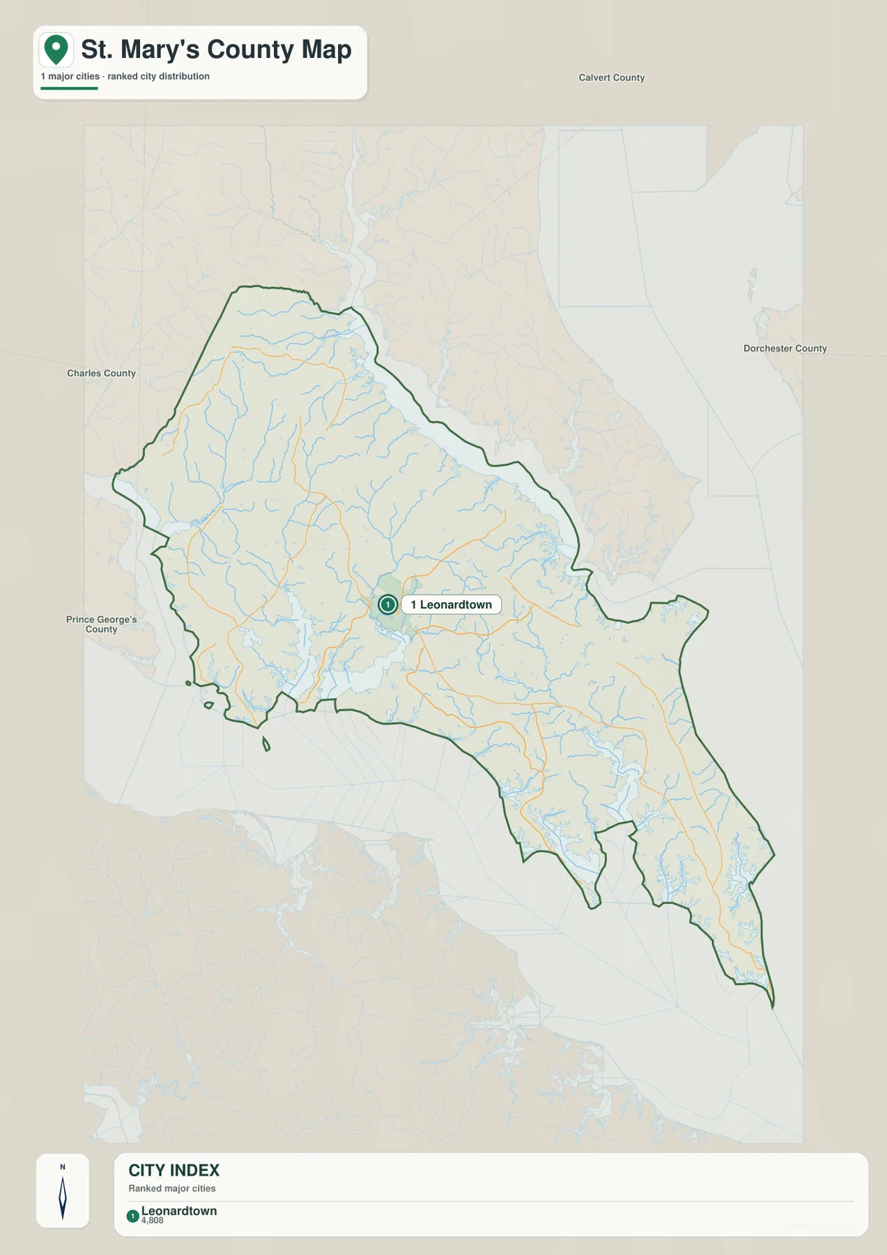
The City Index ranks only Leonardtown and prints the value 4,808 beneath the marker. No reference year or statistical definition is shown, so the figure should not be presented as a current population count. Current population information should come from the latest U.S. Census Bureau or local official data.
A single marker does not mean Leonardtown is the county’s only important settlement area. The general map clearly shows California, Lexington Park, Mechanicsville, Charlotte Hall, Golden Beach, and other communities. The City Index is simply a selected ranked-city view, while the broader map is necessary for understanding where people and roads are concentrated.
Leonardtown does have special administrative importance because St. Mary’s County Government is centered there and county material identifies it as the county seat. In that sense, the single City Index marker is meaningful, but it should not be mistaken for a complete settlement hierarchy.
No connector line or mileage value is printed to Lexington Park, Charlotte Hall, Piney Point, or any other place. The City Index should therefore be used only for Leonardtown’s relative location. Use the full county map and current routing information for travel between communities.
Patuxent River, Breton Bay, and St. Marys River carve the peninsula into distinct coastal sections
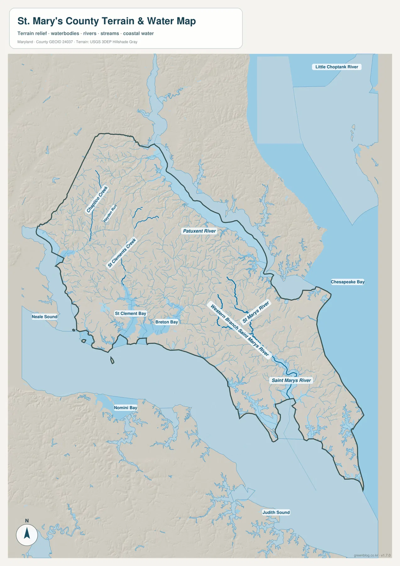
Patuxent River is one of the largest water features along the northeastern and eastern county boundary. It separates St. Mary’s County from the Calvert side before opening toward Chesapeake Bay. St. Mary’s County environmental planning specifically addresses wetlands, waterways, the Chesapeake Bay, and participation in the Patuxent River Commission, showing how central these water resources are to local land planning.
Chaptico Creek and the Wicomico system appear in the northwest, while St. Clements Creek reaches toward St. Clement Bay in the west-central county. Breton Bay cuts inland southwest of Leonardtown and creates a broad low-water corridor close to the county seat. Together, these waterways break up the interior and explain many of the bends in local roads.
St. Marys River and Western Branch St. Marys River are the strongest named streams in the south-central county. They extend through the St. Mary’s College area toward the coast and divide the lower peninsula into narrow ridges and tidal valleys. Around St. George Island, St. Clement Bay and other broad waters become even more dominant.
At Point Lookout, Maryland DNR places the southern tip between Chesapeake Bay and the Potomac River. The terrain-water map is a geographic overview rather than a flood map, tide chart, navigation chart, depth source, or legal water-boundary product. Boating, flood, and safety decisions require current NOAA, FEMA, USGS, Maryland, and local information.
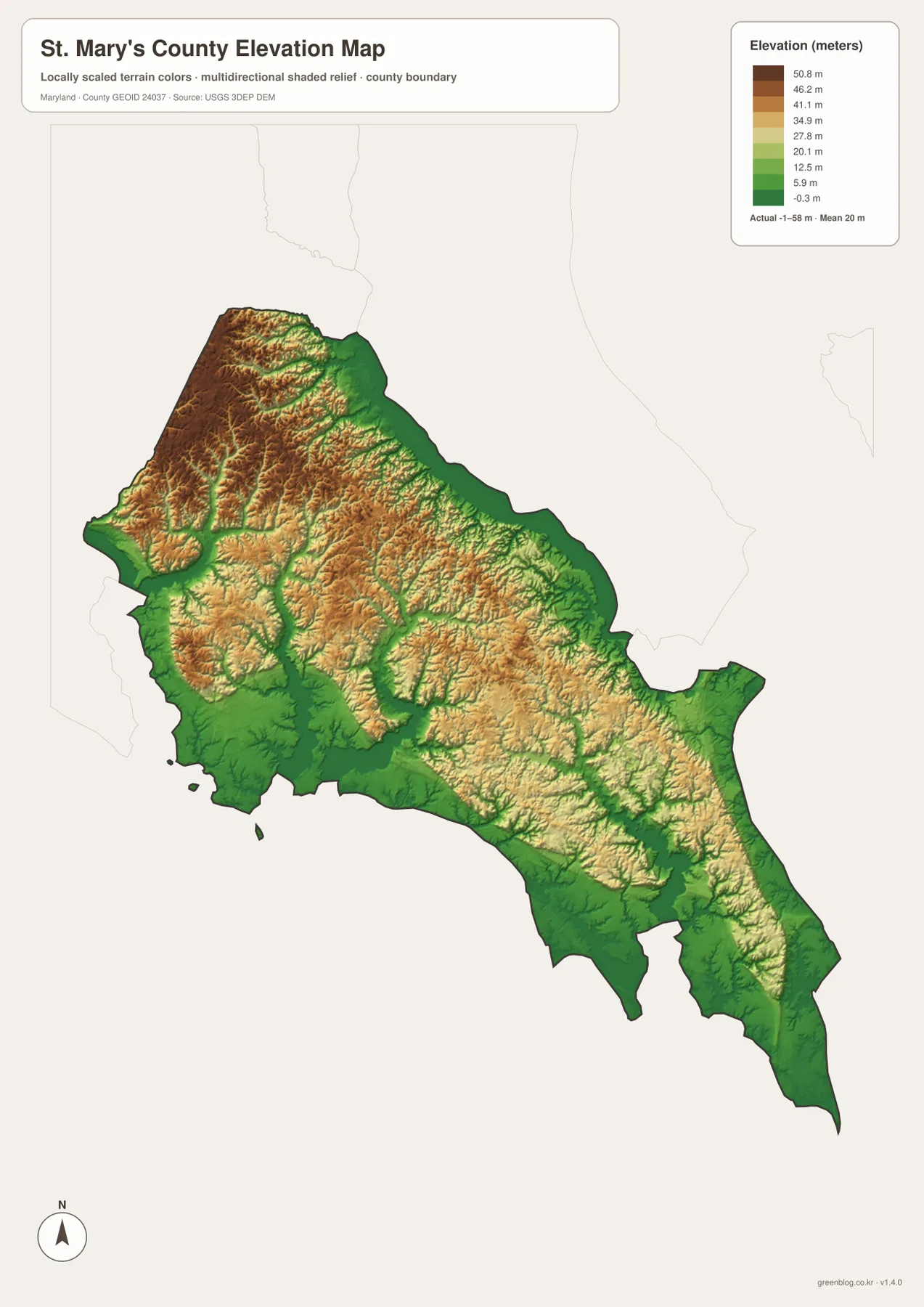
The highest uplands lie in the northwest, while river and bay shorelines drop toward sea level
The elevation graphic reports an actual data range from -1 to 58 meters and a mean elevation of 20 meters. St. Mary’s County is a Coastal Plain county without mountain terrain, but the relative relief is still easy to see. Higher tan and brown uplands dominate the northwest and much of the interior, while green lowlands follow the Patuxent River, Chesapeake shoreline, bays, and creek valleys.
The Charlotte Hall-Mechanicsville side contains the broadest high terrain on this rendering. Chaptico Creek and numerous smaller tributaries cut lower green corridors into those uplands. Similar ridge-and-valley patterns continue west and north of Leonardtown, even though the absolute elevations remain modest.
California and Lexington Park descend toward the Patuxent side, while Breton Bay and St. Clement Bay create broad lowlands closer to Leonardtown’s western coast. South of Callaway, low terrain becomes even more extensive toward Piney Point, St. George Island, and the Point Lookout peninsula. The water map and elevation colors align closely in these coastal sections.
The -1 to 58 meter range is the overall dataset range printed on the supplied image, not an exact road, building, or parcel elevation. Engineering, surveying, drainage design, and flood-risk work require detailed USGS elevation information, professional measurements, and current FEMA or local flood products. Elevation color alone cannot establish flood exposure.
Separate the northern rural roads, Lexington Park corridor, and southern peninsula for easier map use
The general county map is the best starting point for Charlotte Hall, Mechanicsville, Leonardtown, MD 5, MD 235, and MD 245. California and Lexington Park form the most obvious east-central settlement cluster, while Callaway, Piney Point, St. George Island, and Point Lookout define the lower peninsula. The one-place City Index is useful only for Leonardtown, so the water and elevation views become especially important when the goal is to understand the wider county.
Greenwell State Park gives a useful example of the Patuxent side: Maryland DNR describes a 596-acre park directly on the river in St. Mary’s County. Point Lookout State Park provides the opposite southern reference at the Chesapeake-Potomac tip. Together they illustrate how one county contains both an inland-river shoreline and a long exposed southern peninsula.
The downloadable originals are JPG files measuring 2572 × 3638 pixels each. They work well in full-page documents and can be enlarged around Leonardtown, Lexington Park, Piney Point, St. Marys River, or other areas for classroom material, presentations, and personal reference. Enlargement does not add live traffic, parcel boundaries, flood zones, water depth, tides, or survey-grade elevation, so specialized decisions should always use current official data.
Frequently Asked Questions
What is the county seat of St. Mary’s County, Maryland?
Leonardtown is the county seat. St. Mary’s County Government is based there, and the general map shows the courthouse and several state roads clustered around the central settlement.
Why does the City Index show only Leonardtown?
The index is a selected ranked-city graphic, not a complete settlement map. California, Lexington Park, Mechanicsville, Charlotte Hall, and other important communities appear on the general county map even though they are absent from the single-marker City Index.
Can the -1 to 58 meter elevation range be used for surveying or flood decisions?
No. It is the overall data range printed on the supplied elevation graphic and is useful only for broad geographic comparison. Precise property elevation should come from authoritative USGS or professional survey data, and flood decisions should rely on current FEMA and local information.
Map File Information
The ZIP archive contains high-resolution JPG maps of St. Mary's County matching the map themes described on this page.
- Included Files: county and major roads map, City Index map, terrain and water map, elevation map
- Printable Size: 2572 × 3638 pixels each
- File Type: JPG
Related Maps
Sources and References
- St. Mary’s County Government – Commissioners of St. Mary’s County
- Maryland DNR – Point Lookout State Park
- Maryland DNR – Greenwell State Park
- U.S. Census Bureau – TIGER/Line Shapefiles
- USGS – National Hydrography
- USGS – 3D Elevation Program
Green Map creates custom-edited map images using open geographic data sources such as geoBoundaries, Natural Earth, OpenStreetMap, and government open data. These maps are edited visual materials, not raw data files, and are provided for education, documents, presentations, and graphic reference.