Talbot County occupies a deeply indented part of Maryland’s Eastern Shore, with Easton in the interior, St. Michaels and Tilghman Island toward the western bays, Oxford on the Tred Avon side, Trappe along the southern U.S. 50 corridor, and Cordova in the northeast. Chesapeake Bay and Eastern Bay shape the west, while the Tred Avon and Choptank rivers cut into the southern county. The result is a landscape where low farmland, creek valleys, narrow peninsulas, and tidal shoreline sit close together. This page explains the settlements, roads, waterways, and elevation differences shown on the supplied maps, and matching high-resolution JPG files are available together in a downloadable ZIP archive.
Talbot County Government identifies five incorporated towns—Easton, Oxford, Queen Anne, St. Michaels, and Trappe—and county history material identifies Easton as the county seat. The county’s official site also notes more than 600 miles of shoreline, which helps explain why western and southern Talbot look so much more fragmented by water than the inland northeast. The general map adds Cordova and Tilghman Island as useful geographic references beyond the incorporated-town list.
Table of Contents
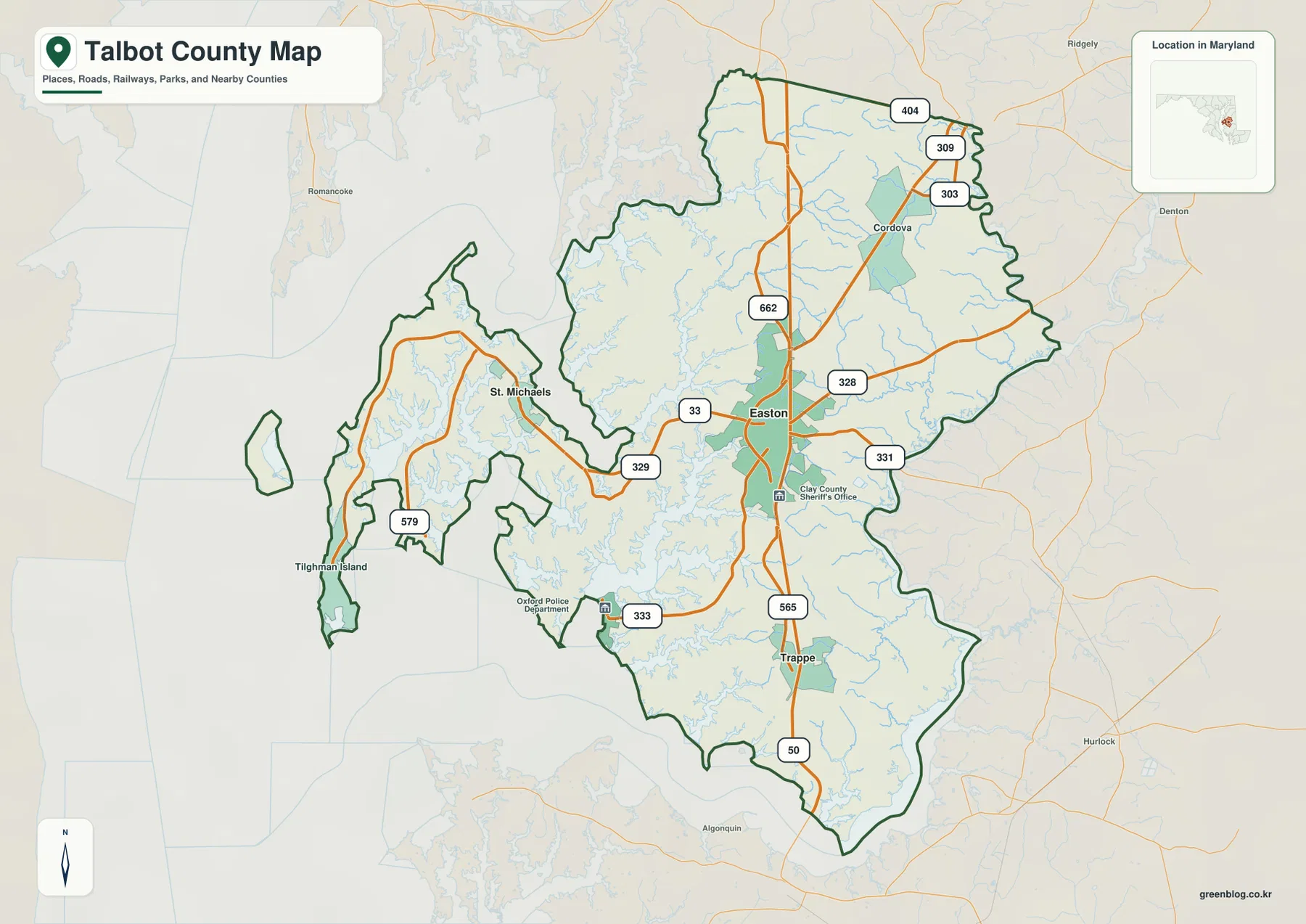
Easton organizes the central road network around U.S. 50 and several state routes
Easton is the clearest orientation point on the general county map. U.S. 50 passes through the center, MD 33 reaches west toward St. Michaels, MD 328 heads east toward Caroline County, and MD 331 serves the southeastern interior. The Talbot County Sheriff’s Office label south of town reinforces the concentration of administrative and transportation activity around Easton.
MD 662 continues north from the Easton area, and farther north U.S. 50 meets the broader MD 404, MD 309, and MD 303 network. Cordova sits in the northeastern interior, surrounded by farmland, small creeks, and widely spaced local roads. Compared with Easton, this part of the county is much less concentrated and reads as a rural landscape first.
Trappe appears south of Easton close to U.S. 50 and MD 565. The highway provides a relatively direct inland connection, but areas west and southwest of Trappe are increasingly interrupted by tidal creeks and peninsulas. Oxford, in particular, sits in a setting where the Tred Avon River matters as much as the road network.
This county map is a geographic reference rather than a live traffic service. Construction, incidents, closures, and flooding are not shown. Use current Maryland transportation information and navigation tools for actual travel, and use the map here to understand which towns sit near the major corridors.
St. Michaels and Tilghman Island reveal the county’s bay-facing side
MD 33 leads west from Easton toward St. Michaels, one of the most recognizable towns on the bay side. Small creeks and inlets become far more frequent around the town than they are in the interior. The road then continues through a narrowing peninsula toward the Tilghman Island area, where MD 579 provides a local road reference.
The land between St. Michaels and Tilghman Island is repeatedly cut by tidal water. That makes the road pattern more curved and constrained than the open farm roads around Cordova and Easton. Straight-line distance can therefore be misleading, especially when two points sit on opposite sides of a creek or bay.
Eastern Bay and Chesapeake Bay dominate the western background. Their shoreline is irregular, with many narrow points and creek mouths extending inland. This gives Talbot County a strong maritime geography even where the road map is dominated by rural land.
Talbot County’s official site describes more than 600 miles of shoreline. The figure does not replace a detailed coastal survey, but it provides useful context for the amount of water visible around St. Michaels, Tilghman Island, Oxford, and the western peninsulas. Boating, depth, and tidal decisions still require dedicated current marine information.
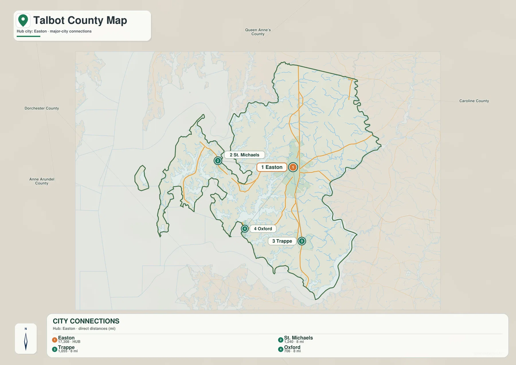
Easton is 8 direct miles from St. Michaels, Trappe, and Oxford on the City Connections map
The City Connections graphic uses Easton as its hub and links it with St. Michaels, Trappe, and Oxford. It prints the values 17,308 for Easton, 1,240 for St. Michaels, 1,055 for Trappe, and 706 for Oxford. Because the graphic provides no reference year or statistical definition, those values should not be presented as current population counts. Current figures should come from the latest U.S. Census Bureau or town sources.
The mileage labels are explicitly described as direct distances. St. Michaels is shown 8 miles from Easton, Trappe 8 miles, and Oxford 8 miles. The matching numbers do not mean the towns occupy the same route: St. Michaels lies west, Trappe south, and Oxford southwest. These are straight-line measurements rather than driving mileage.
Road travel differs sharply among the three directions. St. Michaels follows the MD 33 corridor, Trappe sits close to U.S. 50, and Oxford lies among Tred Avon River branches and tidal creeks. The same 8-mile direct distance can therefore produce different road mileage and travel time.
The graphic is useful for quick orientation around Easton, but it does not include Cordova, Tilghman Island, or Queen Anne. The full county map remains the better source for the broader settlement pattern and actual road choices.
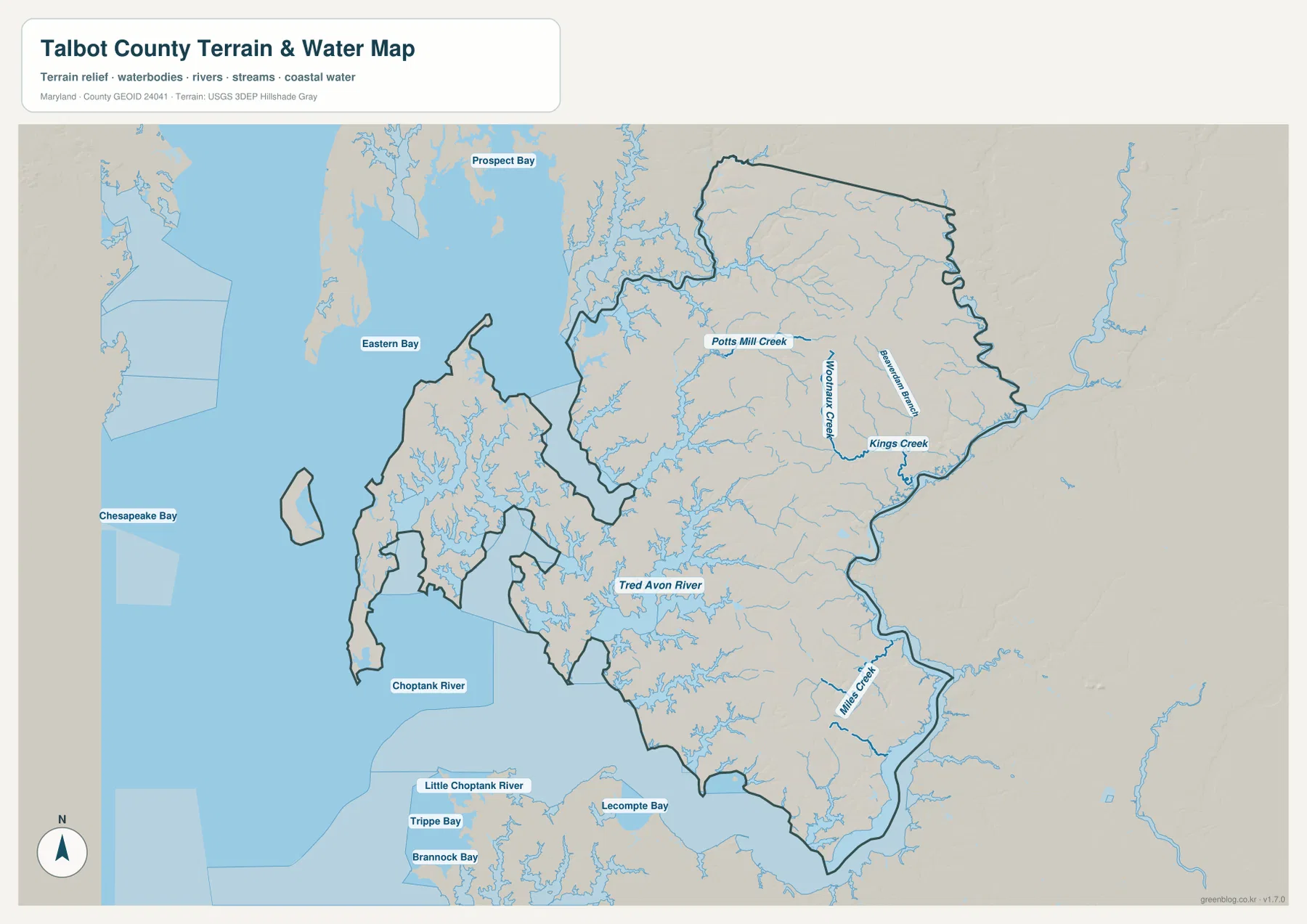
Tred Avon River and Choptank River divide the south while Chesapeake and Eastern bays surround the west
Chesapeake Bay and Eastern Bay provide the largest western water context. Around St. Michaels and Tilghman Island, the shoreline is deeply cut by creeks and small bays. Toward Oxford, Tred Avon River becomes the dominant named waterway and reaches far inland toward the Easton side.
Tred Avon River is the key southwestern river on the supplied map. Oxford sits directly on its shoreline, with numerous tributary creeks branching into the nearby peninsulas. Farther south and east, Choptank River forms a much broader water boundary toward Dorchester County.
Potts Mill Creek and Kings Creek are clearly labeled in the northeastern interior. They are much smaller than the bays and main rivers, but their valleys divide the farmland around the Cordova-Easton side. Those small drainage lines also explain many of the lower green corridors visible on the elevation map.
Little Choptank River, Trippe Bay, Brannock Bay, and Lecompte Bay appear outside the county as regional reference points to the south. The terrain-water map is not a flood map, depth chart, tide forecast, navigation chart, or legal water-boundary product, so specialized coastal decisions require current NOAA, FEMA, USGS, Maryland, and local information.
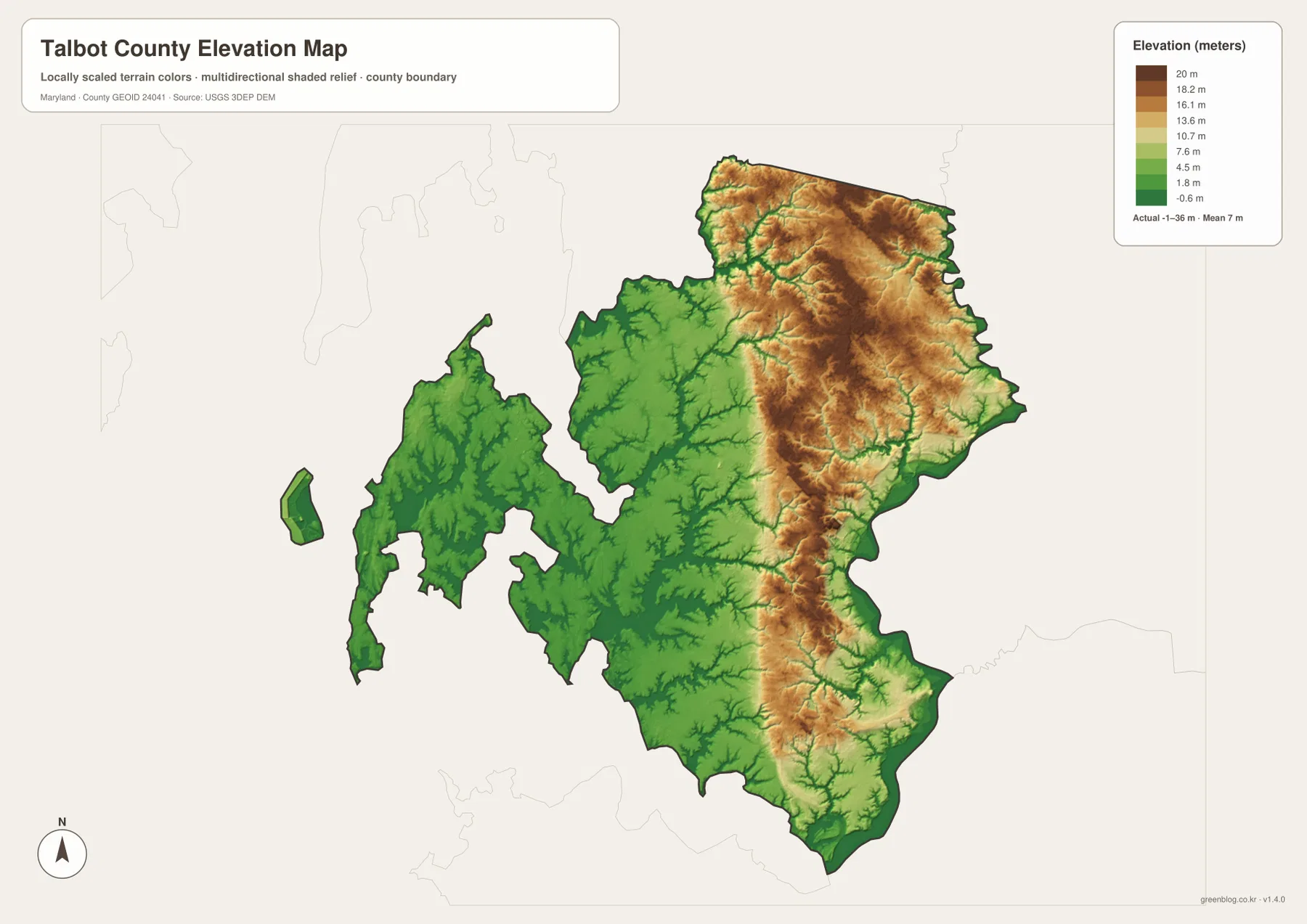
The northeast stands higher than the St. Michaels, Oxford, and bay-side lowlands
The elevation graphic reports an actual data range from -1 to 36 meters and a mean elevation of 7 meters. Talbot County is very low by statewide standards, but the surface is not uniform. Higher tan and brown terrain is concentrated across much of the northeastern and east-central interior, while broad green lowlands dominate the western peninsulas and southern river margins.
The Cordova side and the interior northeast contain the broadest relatively high terrain. Potts Mill Creek, Kings Creek, and smaller tributaries cut green low corridors through those uplands. With a maximum dataset value of only 36 meters, these are gentle Coastal Plain rises rather than hills in the mountainous sense.
St. Michaels, Tilghman Island, and Oxford sit in much lower coastal settings. Tred Avon River and the shoreline around Eastern Bay are surrounded by green terrain, and the Choptank boundary is similarly low. Comparing the elevation colors with the water map shows how closely the lowest land follows river and creek valleys.
The -1 to 36 meter range is the overall data range printed on the supplied elevation map, not the exact elevation of a road, building, or property. Engineering, surveying, drainage design, and flood-risk work require detailed USGS elevation information, professional measurements, and current FEMA or local flood products.
Use Easton for road orientation and the western peninsulas for Talbot County’s coastal character
The general county map is the best starting point for Easton, Cordova, Trappe, U.S. 50, MD 328, and MD 331. St. Michaels, Tilghman Island, MD 33, and MD 579 explain the western coastal corridor, while Oxford makes the most sense when viewed together with Tred Avon River. The City Connections view is useful for the three 8-mile direct-distance comparisons, and the water and elevation maps reveal why the western and southern county is so much more fragmented by low coastal terrain.
Wye Oak State Park provides a useful inland example. Maryland DNR places the 29-acre park in Talbot County at Wye Mills on MD 662, about a mile from the U.S. 50 and MD 404 intersection, and notes that part of the park protects the stream valley behind the historic Wye Oak site. It connects the northern road network with the small-stream terrain visible on the maps.
The downloadable originals are JPG files measuring 3638 × 2572 pixels each. They work well in landscape documents and can be enlarged around Easton, St. Michaels, Oxford, Tred Avon River, or other areas for classroom material, presentations, and personal reference. Enlargement does not add live traffic, parcel boundaries, flood zones, water depth, tides, or survey-grade elevation, so specialized decisions should always use current official data.
Frequently Asked Questions
What is the county seat of Talbot County, Maryland?
Easton is the county seat. Talbot County history material identifies Easton as the county seat, and the general map shows it as the central road and administrative reference along U.S. 50.
Are the 8-mile labels from Easton to St. Michaels, Trappe, and Oxford driving distances?
No. The City Connections graphic labels them as direct distances. St. Michaels, Trappe, and Oxford lie in different directions and use different road corridors, so actual driving mileage and travel time can vary.
Can the -1 to 36 meter elevation range be used for flood or survey decisions?
No. It is the overall elevation data range printed on the supplied graphic. Precise property elevation requires authoritative USGS or professional survey data, while flood decisions should rely on current FEMA and local flood information.
Map File Information
The ZIP archive contains high-resolution JPG maps of Talbot County matching the map themes described on this page.
- Included Files: county and major roads map, City Connections map, terrain and water map, elevation map
- Printable Size: 3638 × 2572 pixels each
- File Type: JPG
Related Maps
Sources and References
- Talbot County Government – About Us
- Talbot County Government – Our History
- Maryland DNR – Wye Oak State Park
- U.S. Census Bureau – TIGER/Line Shapefiles
- USGS – National Hydrography
- USGS – 3D Elevation Program
Green Map creates custom-edited map images using open geographic data sources such as geoBoundaries, Natural Earth, OpenStreetMap, and government open data. These maps are edited visual materials, not raw data files, and are provided for education, documents, presentations, and graphic reference.