Calvert County forms a long, narrow peninsula in southern Maryland between the Patuxent River and Chesapeake Bay. Its main north-south sequence runs from Dunkirk through Huntingtown and Prince Frederick to Lusby and Solomons, while Chesapeake Beach and North Beach form a separate northeastern shoreline cluster. This page follows the roads, communities, streams, coastal water, and elevation shown in the supplied maps, and the matching high-resolution JPG map files can be downloaded together in a ZIP archive.
The official Calvert County profile describes the county as a peninsula bounded by Chesapeake Bay on the east and the Patuxent River on the west, with Prince Frederick serving as the county seat. The same county source identifies North Beach and Chesapeake Beach as the two incorporated towns. That distinction is visible in the maps: Prince Frederick occupies the central interior, while the two towns sit together on the northeastern Bay shore.
Table of Contents
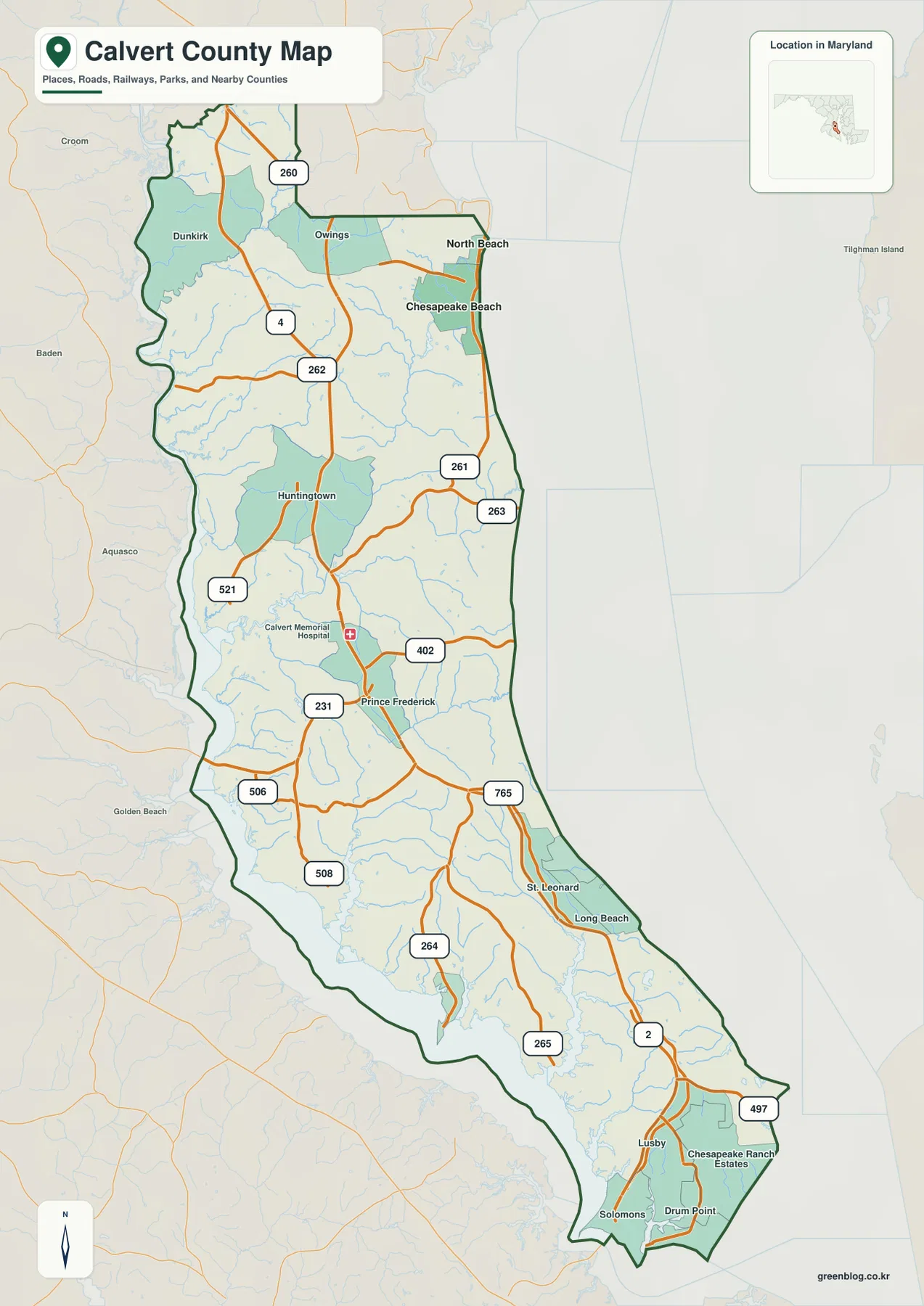
MD 4 follows the county’s long spine from Dunkirk toward Solomons
MD 4 is the easiest road to use as a first reference because it follows the length of Calvert County. It enters the northern part near Dunkirk and Owings, passes Huntingtown and Prince Frederick, and continues south toward Lusby and Solomons. The county is narrow enough that many smaller creeks reach either the Patuxent River or Chesapeake Bay within a relatively short distance of this central corridor, so the road also provides a useful dividing line between the two shoreline systems.
Prince Frederick sits near the middle of the county and works well as a geographic anchor. MD 231 leads toward the Patuxent side, while MD 402 runs toward the Chesapeake side. Farther south, St. Leonard and Long Beach appear before the map reaches Lusby, where MD 2 and MD 497 become visible. Solomons, Drum Point, and Chesapeake Ranch Estates then provide the strongest labels around the lower end of the peninsula.
The northeastern road pattern has a different focus. MD 260 connects the northern interior with the Chesapeake Beach area, and MD 261 follows the Bay side through the North Beach-Chesapeake Beach corridor. MD 263 reaches the coast farther south, while MD 262 crosses the upper interior. These shorter east-west routes are important in a county where the main highway runs lengthwise but many communities sit close to one of the two shorelines.
Several numbered roads also serve the Patuxent-facing side, including MD 521, 506, 508, 264, and 265. They do not form one continuous countywide route like MD 4, but they help place the western communities, creek valleys, and river-facing areas. The overview is intended for geographic orientation rather than live navigation; current construction, congestion, and route restrictions should be checked with Maryland transportation information and a navigation service.
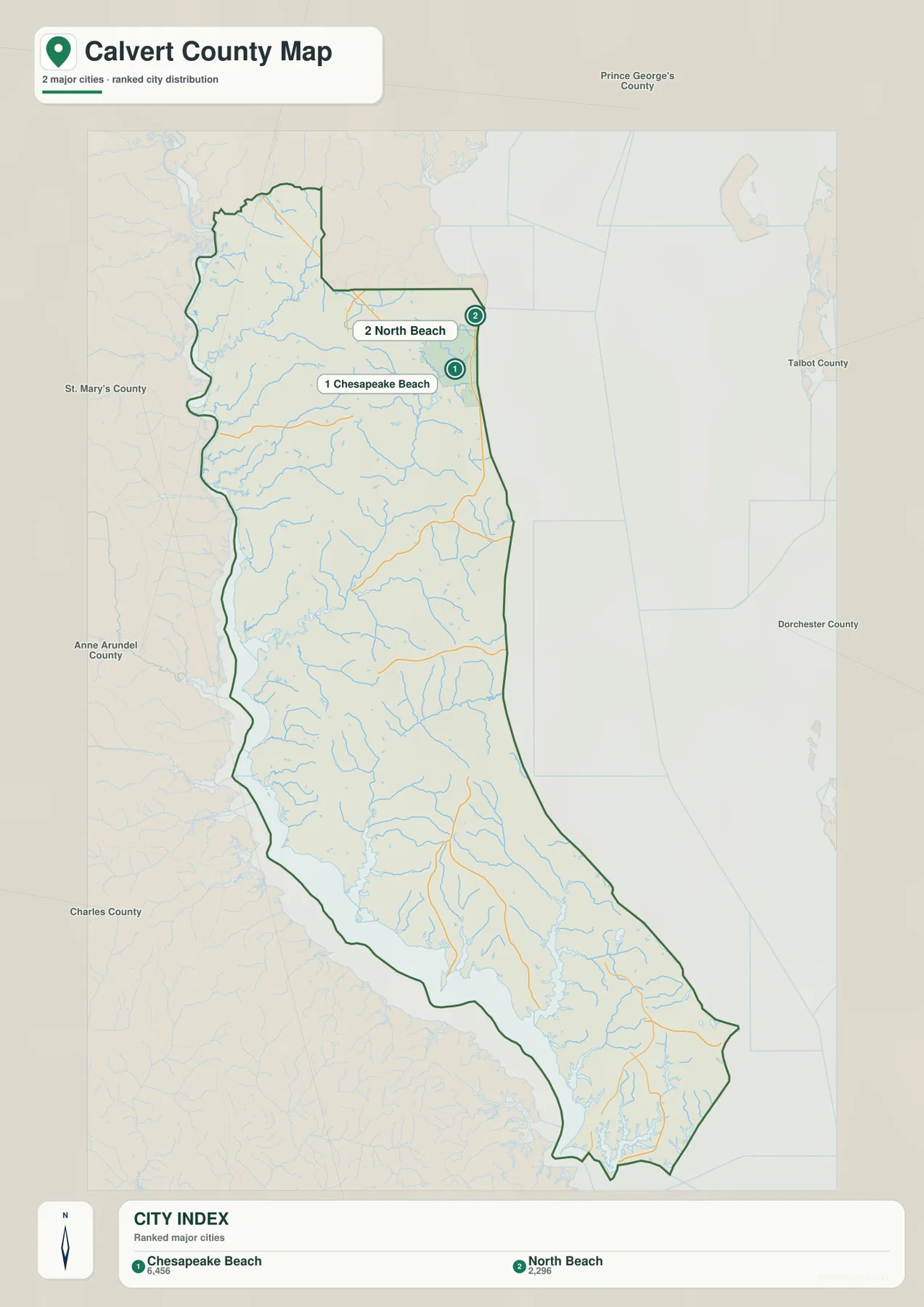
Chesapeake Beach and North Beach form the county’s two-town coastal cluster
The City Index ranks only Chesapeake Beach and North Beach. Its lower panel prints 6,456 for Chesapeake Beach and 2,296 for North Beach, but the graphic does not state the reference year or statistical definition. Those values should therefore be treated only as figures printed on the supplied index, not as current population counts. Current population data should be taken from the latest U.S. Census Bureau source.
Their geographic relationship is much more useful than the printed numbers. Chesapeake Beach sits slightly south of North Beach, and both towns are concentrated on the northeastern Chesapeake Bay shoreline rather than in the middle or southern end of Calvert County. The official county profile identifies exactly these two places as the county’s incorporated towns, so the map provides a clean picture of where the formal town governments are located.
Prince Frederick does not appear in the ranked city index even though it is the county seat. Huntingtown, Dunkirk, Lusby, and Solomons also remain unranked despite their importance as map references. The graphic is therefore not a complete hierarchy of Calvert County communities. It is best used as a simplified view of the two incorporated towns, while the general county map supplies the broader settlement and road context.
No connector lines or mileage labels are included on this City Index. It cannot be used to estimate driving distance between the two towns or from Prince Frederick to the Bay shore. For trip planning, the general road map and a current routing service are the appropriate tools; the City Index is primarily a location and distribution graphic.
A central divide sends short creeks toward the Patuxent River or Chesapeake Bay
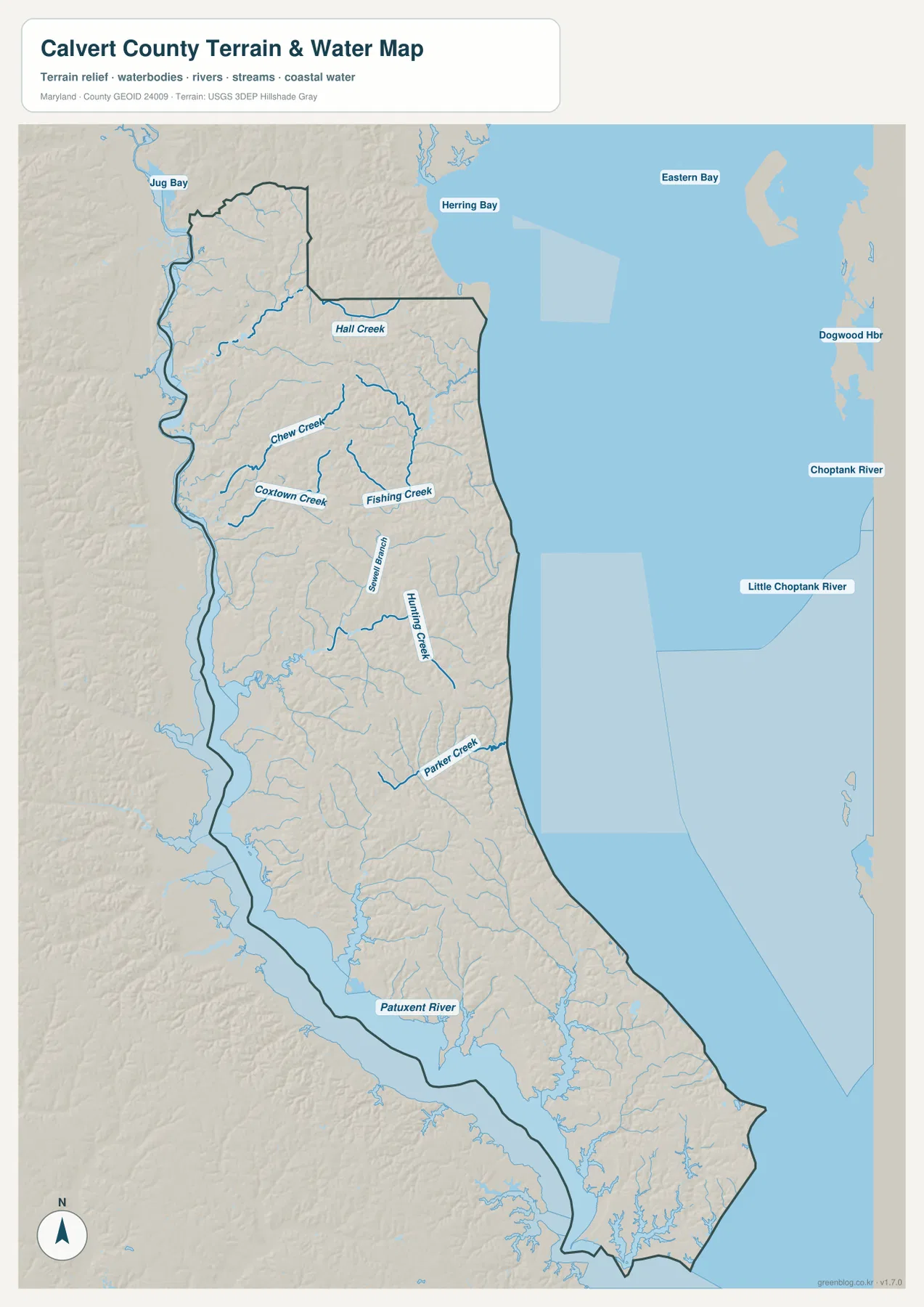
The terrain-water map makes the peninsula’s drainage pattern especially clear. The Patuxent River runs along the western side, while Chesapeake Bay occupies the entire eastern edge. Between them is a higher central belt, and short streams descend from that interior toward one coast or the other. The official county profile describes the same broad pattern, noting that a central upland forms a divide between drainage toward the Bay and drainage toward the Patuxent.
In the north, Hall Creek heads toward the Chesapeake side, while Chew Creek and Coxtown Creek occupy the Patuxent-facing side. Fishing Creek is another prominent northeastern drainage. Farther south, Swamp Branch and Hunting Creek run through the middle of the peninsula before the map reaches Parker Creek closer to the Bay. The names are useful because they show that Calvert County is not organized around one large central river; many relatively short watersheds split away from the county’s interior spine.
The water geometry becomes even more obvious toward the south. Patuxent River embayments and smaller tributaries cut deeply into the western shoreline, while the eastern boundary stays exposed to the open Chesapeake. Near Solomons, the peninsula narrows and the two major water bodies come much closer together. Jug Bay appears beyond the northwestern edge, and Herring Bay lies outside the northeastern side, helping place Calvert County within the larger Chesapeake system.
The Chesapeake shore is also known for the Calvert Cliffs. Maryland’s Department of Natural Resources says the cliffs extend for roughly 24 miles along the county’s Bay shoreline, and Calvert Cliffs State Park near Lusby is one of the best-known places associated with that terrain. The supplied water map is not a flood map, erosion model, or nautical chart, however. It does not provide channel depth, tides, active cliff hazards, or flood probability, so safety and navigation decisions require current specialized agency data.
Elevation stays modest but repeatedly rises along the county’s interior ridges
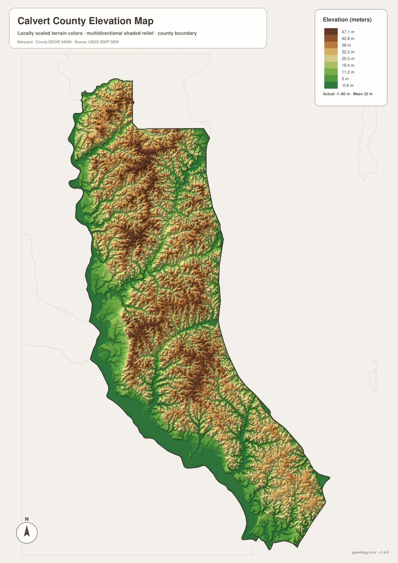
The elevation map reports an actual county range from -1 to 60 meters and a mean elevation of 22 meters. Although those figures are low compared with mountain counties, the locally scaled colors reveal substantial small-scale relief. Browns and tan shades trace higher interior ridges, while greens occupy many creek valleys and the low margins along the Patuxent River and Chesapeake Bay.
The northern landscape around Dunkirk and Owings already shows the pattern: ridges remain higher between stream valleys, and lower green corridors extend toward both shorelines. Similar relief continues around Huntingtown and Prince Frederick, where the interior is broken into many narrow uplands rather than one flat plateau. Comparing the water map makes the pattern intuitive because Hall Creek, Fishing Creek, and Hunting Creek follow lower ground between the ridges.
South of Prince Frederick, the peninsula narrows and low shoreline terrain occupies a larger share of the map around Lusby and Solomons. The county profile describes the Chesapeake side as having steep cliffs in places, while the Patuxent side slopes more gradually toward the river. The elevation image supports that broad contrast without implying that every part of either shoreline has the same slope.
The colored surface is a countywide terrain reference, not a parcel survey. The printed -1 to 60 meter range should not be applied directly to a house, road, construction site, or flood decision. Precise work should use authoritative elevation data such as the USGS 3D Elevation Program, professional survey measurements, and dedicated flood information where appropriate.
Finding Prince Frederick, Solomons, and the two northeastern towns quickly
For roads and community locations, begin with MD 4 and use Prince Frederick as the central anchor. Huntingtown and Dunkirk lie to the north, while St. Leonard, Lusby, and Solomons continue south. Chesapeake Beach and North Beach are easier to locate separately on the northeastern side around MD 260 and MD 261. The Patuxent-facing secondary roads, including MD 231, 521, 506, 508, 264, and 265, help organize the western side of the peninsula.
For natural geography, start with the Patuxent River and Chesapeake Bay, then add Hall Creek, Chew Creek, Fishing Creek, Hunting Creek, and Parker Creek to see how drainage divides across the narrow county. If elevation is the main question, compare the brown interior ridges with the greener shoreline and creek valleys. Moving between the road, water, and elevation views explains why Calvert County can look simple in outline while containing a dense network of small ridges and watersheds.
The downloadable originals are JPG files measuring 2572 × 3638 pixels each. They can be placed on a full document page or enlarged around a particular community, road, creek, or shoreline for classroom material, presentations, and personal reference. Enlarging the images does not add live traffic, parcel boundaries, flood zones, nautical depth, or survey-grade elevation, so specialized decisions should always be checked against current official sources.
Frequently Asked Questions
Which places are the incorporated towns in Calvert County?
The official county profile identifies Chesapeake Beach and North Beach as Calvert County’s two incorporated towns. Both sit together on the northeastern Chesapeake Bay shoreline and both appear on the supplied City Index. Prince Frederick is the county seat, but it is not one of the two ranked towns on that graphic.
Why is MD 4 the most useful road for orienting the Calvert County map?
MD 4 follows much of the county’s long north-south axis, connecting the Dunkirk-Huntingtown area with Prince Frederick and continuing toward Lusby and Solomons. Smaller routes such as MD 260, 261, 231, 402, and 765 then branch toward the two shorelines, making MD 4 a convenient first reference before adding local detail.
Can the -1 to 60 meter elevation range be used for flood or construction decisions?
No. The range summarizes countywide terrain variation and does not replace parcel-level survey measurements or flood-risk products. Use authoritative USGS elevation data or professional surveying for precise elevations, and consult current FEMA and local flood information when flood exposure matters.
Map File Information
The ZIP archive contains high-resolution JPG maps of Calvert County matching the map themes described on this page.
- Included Files: county and major roads map, City Index map, terrain and water map, elevation map
- Printable Size: 2572 × 3638 pixels each
- File Type: JPG
Related Maps
Sources and References
- Calvert County Government – Calvert County Profile
- Maryland Department of Natural Resources – Calvert Cliffs State Park
- U.S. Census Bureau – TIGER/Line Shapefiles
- USGS – National Hydrography
- USGS – 3D Elevation Program
Green Map creates custom-edited map images using open geographic data sources such as geoBoundaries, Natural Earth, OpenStreetMap, and government open data. These maps are edited visual materials, not raw data files, and are provided for education, documents, presentations, and graphic reference.