Orange County is centered on Paoli, with Orleans to the north and the neighboring resort towns of French Lick and West Baden Springs to the west. You can download the high-resolution JPG ZIP directly from this page. The larger originals are useful for reading road shields, creek names, river bends, and elevation shading. This Orange County Indiana Map page combines the Paoli road network with a four-place city-connections view, Lost River and Patoka waterways, and a 142–297 meter relief surface cut by deep valleys and high ridges.
Paoli is the best central reference because State Road 37 runs north–south through the area and U.S. 150 links the county seat with the western side. Indiana’s Orange County page identifies Paoli as the county seat and lists French Lick, Paoli, Orleans, and West Baden Springs among the county’s cities and towns. Orleans provides a simple northern reference, while French Lick and West Baden Springs sit close together in the rugged west. Once those positions are fixed, the eastern and southern rural roads become much easier to place.
The physical-geography views show why Orange County roads twist so often outside Paoli. Lost River occupies a broad low corridor across the northern interior, French Lick Creek and Lick Creek divide the western and central hills, and Patoka River and Patoka Lake define much of the southern water framework. The supplied elevation legend gives an actual range of about 142 to 297 meters and a mean of 208 meters. Low river valleys sit close to steep western and southeastern ridges, producing much stronger relief than the general road map alone suggests.
Table of Contents
Paoli ties the western resort towns to Orleans and the eastern hill roads
Paoli has the clearest central road position on the general map. State Road 37 runs through the town from north to south, while U.S. 150 arrives from the west through the Prospect and West Baden Springs side. Police, hospital, and emergency-related labels near Paoli provide extra visual anchors when the local road network becomes dense. Starting here gives the county a simple east–west and north–south framework.
West of Paoli, West Baden Springs and French Lick form a close pair of developed areas. U.S. 150 approaches the Paoli side through Prospect, U.S. 56 passes the French Lick area, and State Road 145 heads south from the western valley. The roads bend noticeably around the short ridges and creek valleys, so this side of the county looks less like a simple grid than the central Paoli area.
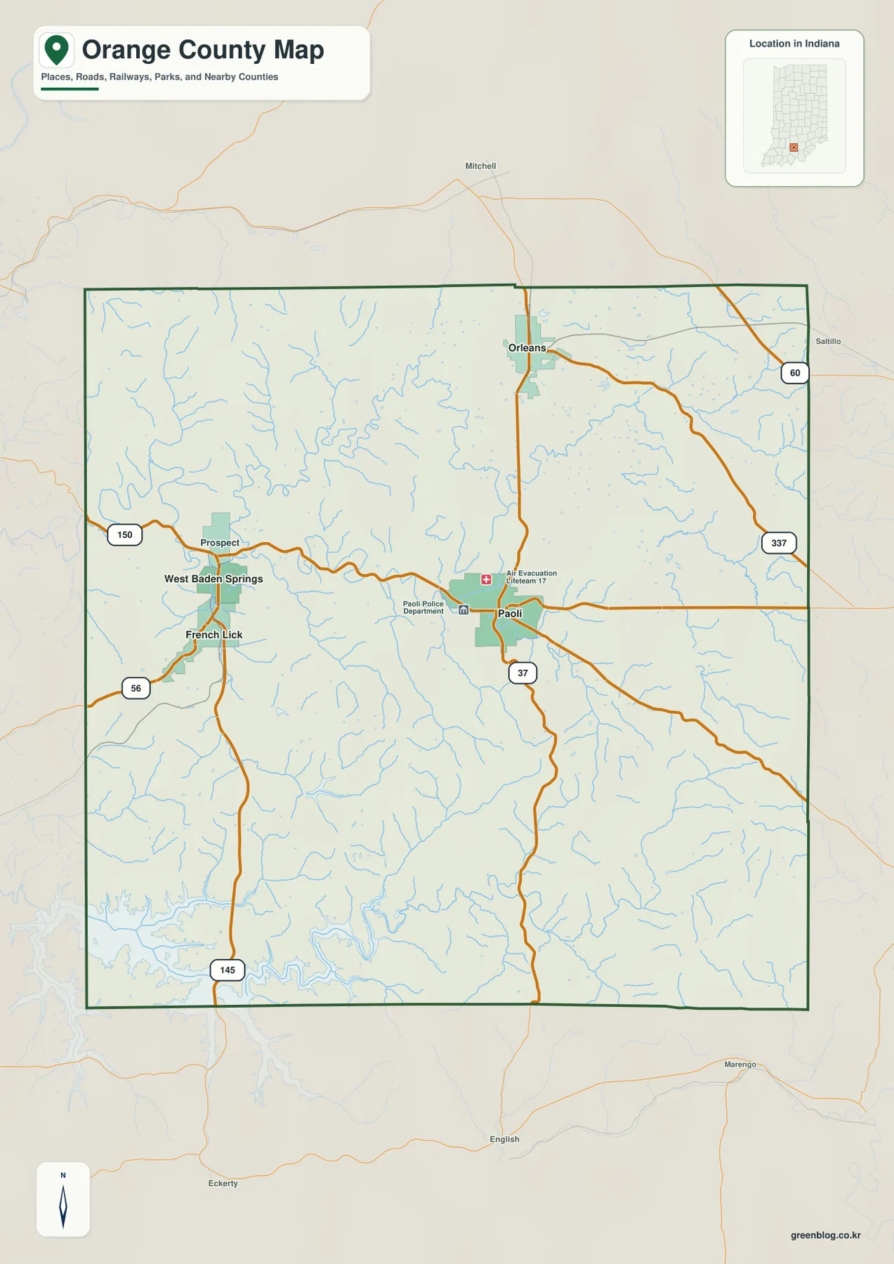
Orleans lies north of Paoli and is the most noticeable developed area in the northern county. State Road 37 connects the two broad locations, while the road network around Orleans continues toward the northeastern edge. Route 60 appears near that side of the county, and State Road 337 provides another curved eastern reference from the Paoli area into the hills.
The southern half has fewer large settlement labels. State Road 37 continues south from Paoli and State Road 145 runs toward the southern boundary from the French Lick side. Near Patoka Lake, roads bend around reservoir arms and creek valleys. The general map is useful for establishing direction here, but the terrain-and-water image explains the southern landscape much more clearly.
The connector map places Orleans, French Lick, and West Baden Springs around Paoli
The supplied city-connections graphic uses Paoli as the hub. The printed index values are 3,125 for Paoli, 2,235 for Orleans, 1,828 for French Lick, and 543 for West Baden Springs. These figures belong to the supplied map edition rather than a live demographic feed. The geographic message is straightforward: Orleans sits about 7 miles north of Paoli, while French Lick and West Baden Springs are each shown about 8 miles to the west.
| Map rank | Place | Value printed on map | Straight-line distance from Paoli | Direction |
|---|---|---|---|---|
| 1 | Paoli | 3,125 | Hub | Central |
| 2 | Orleans | 2,235 | 7 mi | North |
| 3 | French Lick | 1,828 | 8 mi | West |
| 4 | West Baden Springs | 543 | 8 mi | West |
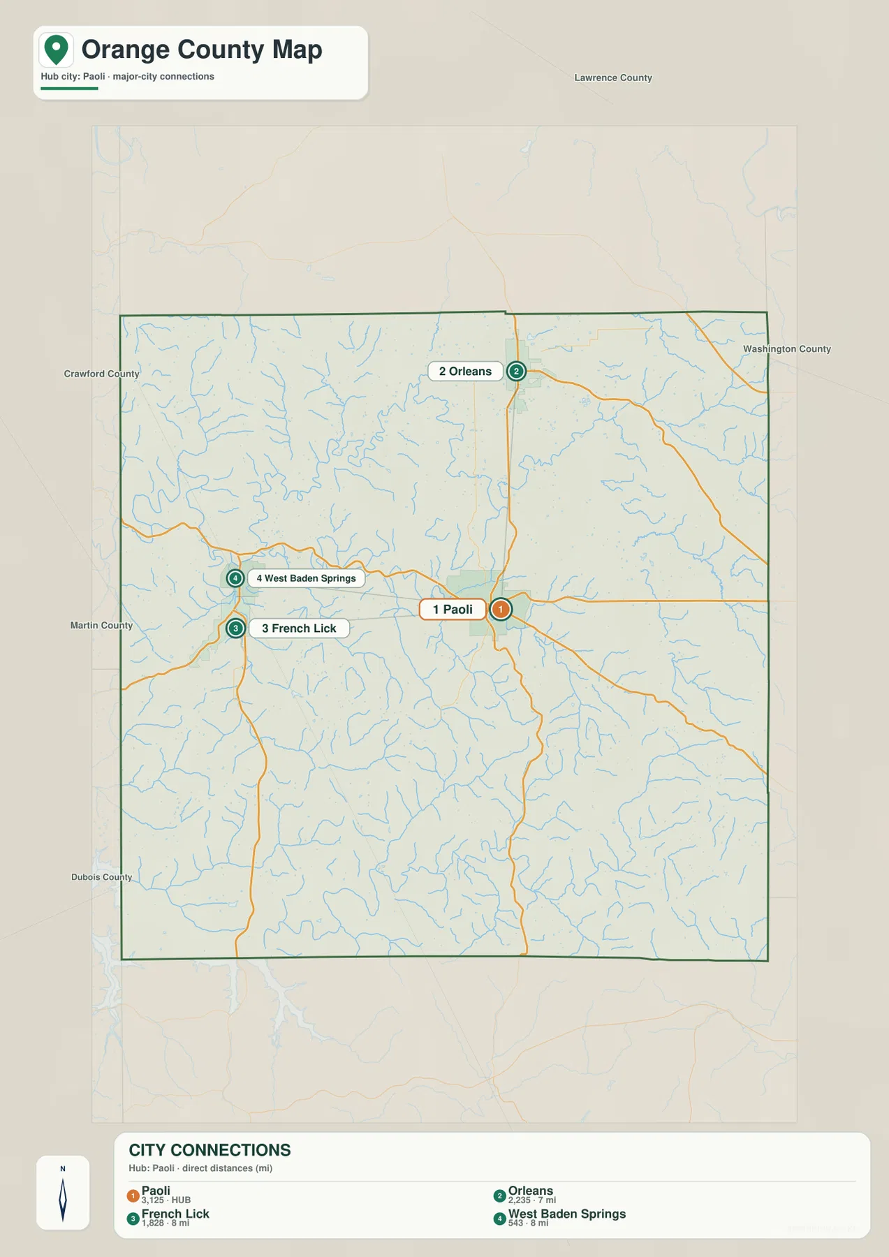
The 7- and 8-mile labels are direct point-to-point distances, not driving mileage. Actual road travel depends on the route and the exact starting and ending locations. Orleans has a fairly direct north–south relationship with Paoli along the State Road 37 side, but the western trip toward French Lick and West Baden Springs follows more curved roads through hill country.
The connector graphic is intentionally limited to four highlighted places. Prospect and the smaller eastern and southern labels belong on the general map rather than this simplified view. Use the connector image for quick spacing and direction, then return to the road map for route details. Present-day population work should use a current official statistical source instead of treating the printed index values as live counts.
Lost River and Patoka waterways cut broad low corridors through the hills
Lost River is the strongest northern water feature on the terrain-and-water map. It winds through the north-central interior in a wide, irregular valley, while South Fork Lost River occupies a separate eastern corridor. Both waterways align with some of the broadest green lowlands on the elevation map and provide a useful way to separate the northern hills into distinct drainage areas.
Lick Creek runs across the central county, with Upper Sulphur Creek and Willow Creek dividing nearby ridges. French Lick Creek forms a strong western valley and continues toward the Tucker Lake area. Simmons Creek and Noel Creek provide eastern references around the South Fork Lost River side. The result is a densely dissected hill landscape rather than one simple main river with only a few tributaries.
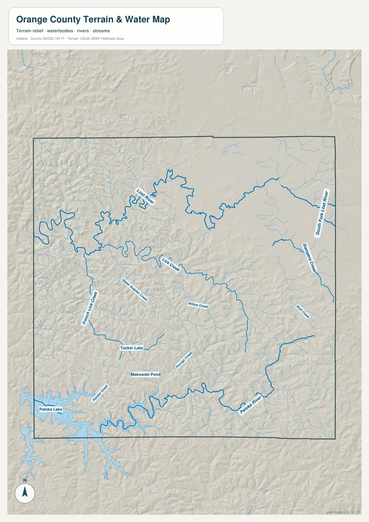
Patoka River crosses the southeastern and southern terrain, while Patoka Lake reaches the southwestern edge of the county. Painter Creek and Youngs Creek create additional southern valleys, and Tucker Lake and Makowski Pond provide small fixed water landmarks. Indiana DNR describes Patoka Lake as an 8,800-acre lake located south of the historic French Lick and West Baden towns, which matches the broad reservoir setting visible along the county’s southwest side.
This Orange County water view is for locating rivers, creeks, lakes, and terrain relationships. For Orange County, flood exposure, current water conditions, navigation rights, ownership questions, and legal stream limits should be checked with the agency source created for that purpose. Those questions require the appropriate current USGS, FEMA, Indiana DNR, or local source.
The 142–297 m relief places Lost River and Patoka Lake below steep western and southeastern ridges
The elevation legend reports an actual Orange County range of about 142 to 297 meters and a mean of 208 meters. Green areas mark lower terrain, while yellow, tan, and brown show increasingly higher ground. The broadest low zones follow Lost River through the north-central county and Patoka Lake in the southwest. Strong ridges rise immediately around many of those valleys.
The northwest contains closely packed, short ridges cut by Lost River tributaries. Around French Lick and West Baden Springs, creek valleys stay low while the surrounding hills rise quickly, creating a sharp topographic contrast over short distances. That terrain helps explain the curved road network on the general map and the compact valley setting of the western towns.
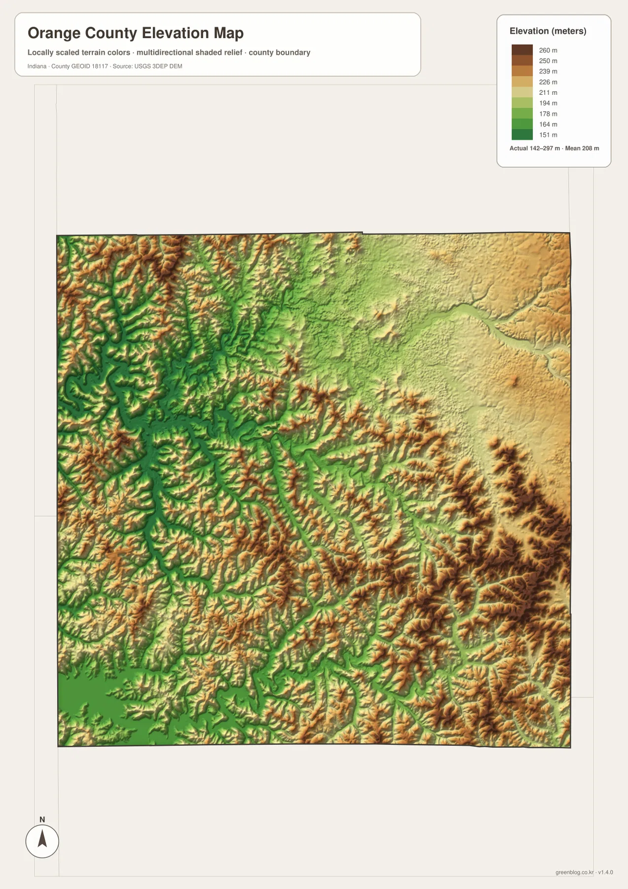
The northeastern interior includes a broad Lost River and South Fork Lost River lowland, but the surface rises away from the channels into yellow and tan uplands. Around Paoli, Lick Creek and smaller tributaries create lower corridors between moderate hills. Farther southeast, the relief grows stronger and the ridge pattern becomes much more closely spaced.
The southeast contains some of the highest terrain on the map. Patoka River and smaller streams cut green valleys into dark tan and brown ridges, while the Patoka Lake side of the southwest remains much lower. Comparing those two southern areas shows why Orange County cannot be summarized as uniformly high or low; broad valleys and strong hills alternate across short distances.
The 142–297 meter range is intended for county-scale terrain comparison. For precise Orange County parcel elevations, building sites, road grades, or drainage design, use original elevation data such as the USGS 3D Elevation Program or measurements from a qualified survey.
Keep Paoli fixed while matching western towns to Lost River valleys and Patoka relief
For settlements and roads, begin with Paoli near State Road 37 and U.S. 150. Move north to Orleans, then west to French Lick and West Baden Springs. State Road 145 provides a useful southern western reference, while Routes 337 and 60 help organize the hill country toward the northeast.
The connector map is best when the goal is to compare Paoli directly with Orleans, French Lick, and West Baden Springs. It shows approximately 7 miles to Orleans and 8 miles to each western town by straight-line distance. Driving mileage will differ because the western routes curve through valleys and ridges.
For physical geography, locate Lost River and Lick Creek first, then add French Lick Creek, South Fork Lost River, Patoka River, and Patoka Lake. Switching to the elevation image at those same positions shows the waterways occupying low green corridors while the northwest and southeast rise sharply. The comparison ties the settlement map to the county’s deep valley-and-ridge landscape.
The WebP images on this page are reduced previews. The Orange County archive contains four original 2572×3638-pixel JPG files covering the general county map, city-connections map, terrain-and-water map, and elevation map. For Orange County, the full-size JPGs are the better choice when you need to print the map or enlarge small road, creek, river, lake, and place labels.
A useful comparison is to keep Paoli fixed as the central reference. Find Orleans, French Lick, and West Baden Springs on the general map, compare their direct spacing on the connector view, move to the water map to locate Lost River and Patoka Lake, and finish on the elevation image by matching the low valleys to the surrounding ridge belts.
Frequently Asked Questions
How far are Orleans, French Lick, and West Baden Springs from Paoli on the connector map?
The supplied graphic places Orleans about 7 miles from Paoli and both French Lick and West Baden Springs about 8 miles away. All three measurements are straight-line distances between mapped place points, not driving mileage, so actual road distances will vary.
Which water features are easiest to recognize?
Lost River and South Fork Lost River are the strongest northern references. Lick Creek and French Lick Creek organize the center and west, while Patoka River and Patoka Lake anchor the southern side. Tucker Lake and Makowski Pond provide smaller landmarks. Use this Orange County water image to locate rivers, creeks, and lakes; it is not a floodplain or legal-boundary map.
Can the 142–297 m elevation range be used for exact site measurements?
No. The elevation image gives a county-wide range with a mean of 208 meters and is intended for comparing river and lake lowlands with surrounding ridges. For parcel-scale elevations, construction grades, roadway design, or drainage work in Orange County, consult original terrain data or a qualified survey.
Map File Information
The Orange County ZIP combines the general road-and-place map, Paoli city-connections map, terrain-and-water map, and elevation map as full-resolution JPG originals.
- File Type: ZIP containing four 2572×3638px JPG files
Related Maps
Sources and References
The article is based primarily on the supplied Orange County map set and asset manifest. The following official sources provide Paoli, county, Patoka Lake, boundary, hydrography, and elevation context.
- IN.gov – Orange County – official county information including Paoli as county seat and French Lick, Paoli, Orleans, and West Baden Springs
- Indiana DNR – Patoka Lake – official information on the 8,800-acre reservoir south of French Lick and West Baden Springs
- U.S. Census Bureau TIGER/Line Shapefiles – boundary reference for Orange County and its place framework
- USGS National Hydrography – reference data for Lost River, creeks, Patoka River, and mapped water features
- USGS 3D Elevation Program – source terrain data for detailed elevation work
Green Map creates custom-edited map images using open geographic data sources such as geoBoundaries, Natural Earth, OpenStreetMap, and government open data.
These maps are edited visual materials, not raw data files, and are provided for education, documents, presentations, and graphic reference.