El Dorado County stretches from the lower Sierra Nevada foothills east of Sacramento to Lake Tahoe and the Nevada state line. Placerville, the county seat, anchors the western slope, with El Dorado Hills, Cameron Park, Diamond Springs, Coloma, Camino, and Pollock Pines spread around the road network west of the high Sierra. Farther east, settlement thins dramatically before Meyers and South Lake Tahoe appear in the Lake Tahoe Basin. The county is therefore best understood as a long transition from foothill communities to mountain river country and a high alpine lake basin.
You can download the original high-resolution A3 JPG files from this El Dorado County Map page in one ZIP. The package contains the county reference map, city-distribution map, and terrain-and-water map. There is no separate elevation map in the supplied package, so descriptions of terrain stay with the actual relief shading, waterways, and official county geographic information.
Table of Contents
Placerville anchors the western slope and US 50 carries the map east
El Dorado County’s official profile identifies Placerville as the county seat. On the reference map it appears in the western interior near the junction of U.S. 50 and Highway 49. Diamond Springs lies just to the south, while Cameron Park and El Dorado Hills extend west toward the Sacramento side. Coloma and Georgetown occupy separate foothill valleys to the northwest.
U.S. 50 is the most useful route for understanding the county from end to end. East of Placerville it passes Camino and Pollock Pines before entering a long stretch of Sierra mountain country and eventually reaching Meyers and South Lake Tahoe. An El Dorado County Highway 50 corridor document describes the route as running beside the South Fork American River for more than thirty miles after it enters Eldorado National Forest, tying the road directly to one of the county’s major river valleys.
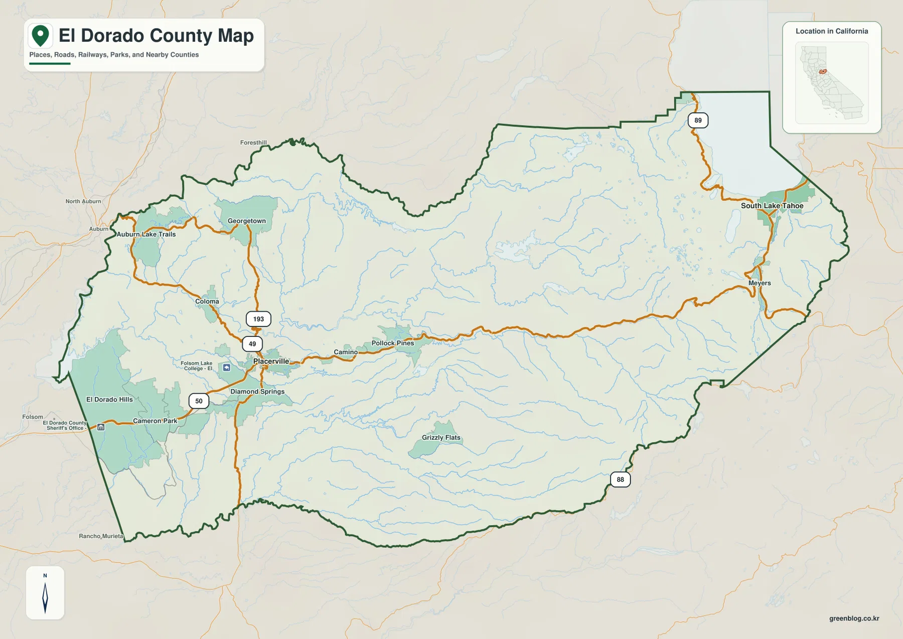
The western end around El Dorado Hills and Cameron Park has a much denser road and settlement pattern than the interior mountains. East of Placerville, development becomes more linear along the highway. Beyond Pollock Pines, large community labels become scarce and the map is dominated by forest, streams, ridges, and the main trans-Sierra road. That change makes U.S. 50 a simple visual guide to the county’s western-slope geography.
Coloma and Highway 49 connect Gold Country history with the American River
Coloma appears northwest of Placerville along Highway 49 and the South Fork American River. California State Parks identifies Marshall Gold Discovery State Historic Park in Coloma as the place where James Marshall discovered gold in 1848, setting off the California Gold Rush. That history gives the small map label unusual importance: Coloma is directly tied to the same river system that cuts across the western slope today.
Highway 49 provides a north–south foothill reference that complements the east–west role of U.S. 50. From the Placerville area it connects toward Coloma and Georgetown to the north, while the Diamond Springs side lies to the south. Roads around these historic foothill communities bend through river valleys and rolling terrain rather than following the straighter pattern found in lower western development.
South Lake Tahoe and Placerville are the county’s two incorporated cities
The supplied city-distribution graphic ranks South Lake Tahoe first at 21,269 and Placerville second at 10,762. Those figures are comparison values printed in the provided image rather than the newest Census estimates. Current demographic work should use an official statistical source.
Their locations are much more important than the ranking alone. Placerville is on the western slope, while South Lake Tahoe sits at the far eastern end in the Lake Tahoe Basin. El Dorado County’s official profile also states that these are the county’s two municipalities, with South Lake Tahoe the larger city and Placerville the county seat. Much of the county’s population lives outside the two incorporated areas, so the broader reference map remains essential for communities such as El Dorado Hills, Cameron Park, Camino, and Pollock Pines.
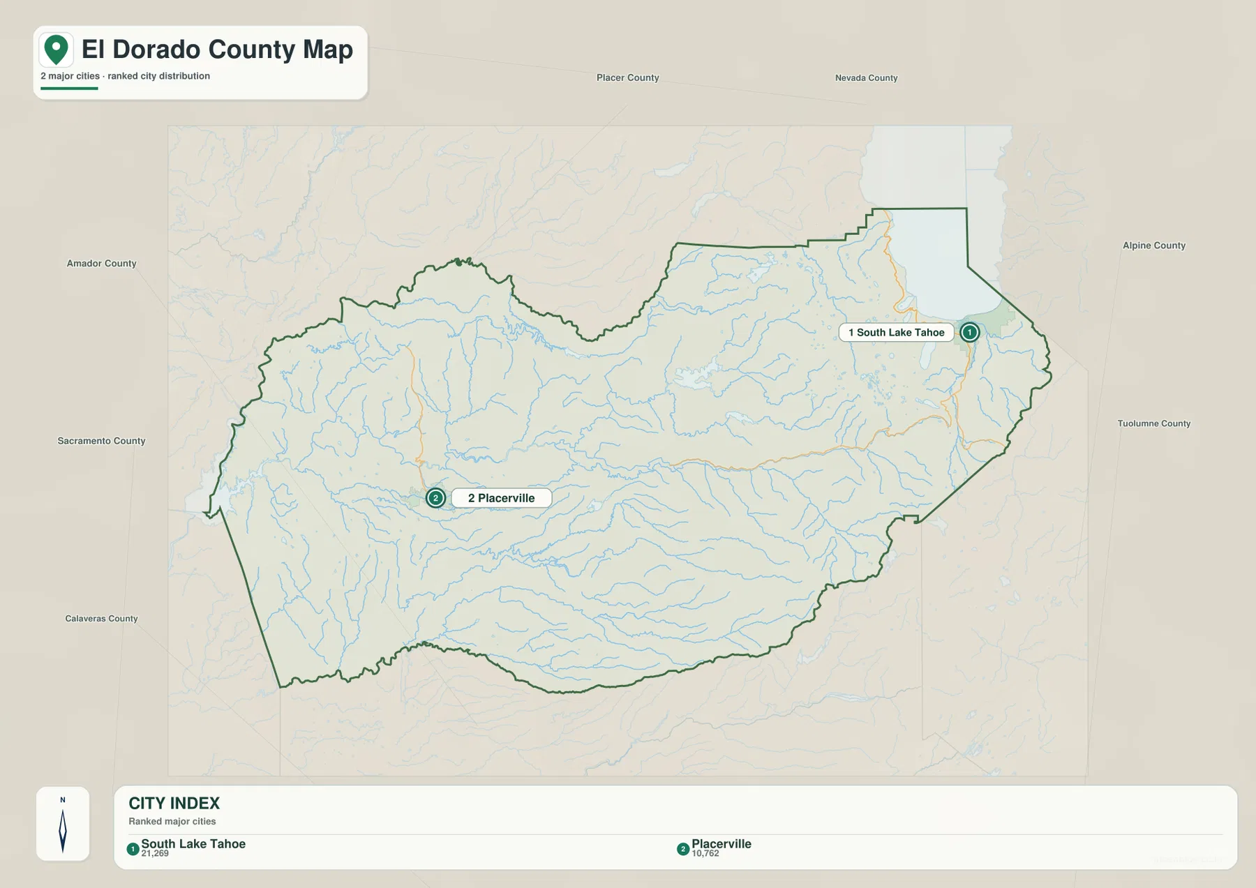
This unusually wide separation gives the city map a clear purpose. It shows that the two municipalities do not form one continuous urban corridor. Placerville belongs to the Sacramento-facing western slope, while South Lake Tahoe belongs to a separate high-mountain basin beyond a long section of sparsely settled Sierra terrain.
The South Fork American River follows a major corridor across the western slope
The South Fork American River is the strongest water reference through the middle of the county. On the terrain map it runs westward from the high Sierra through a long mountain valley, roughly paralleling the U.S. 50 corridor for part of its route. Forebay Lake is labeled along this central drainage, and numerous smaller tributaries descend from surrounding ridges.
El Dorado County Parks manages the South Fork American River from below Chili Bar Dam to the Salmon Falls area and publishes dedicated river maps. The county describes a roughly twenty-mile managed stretch that includes major whitewater sections. That official river presence reinforces what the terrain map shows: the South Fork is not a minor local creek but one of the defining valleys of western El Dorado County.
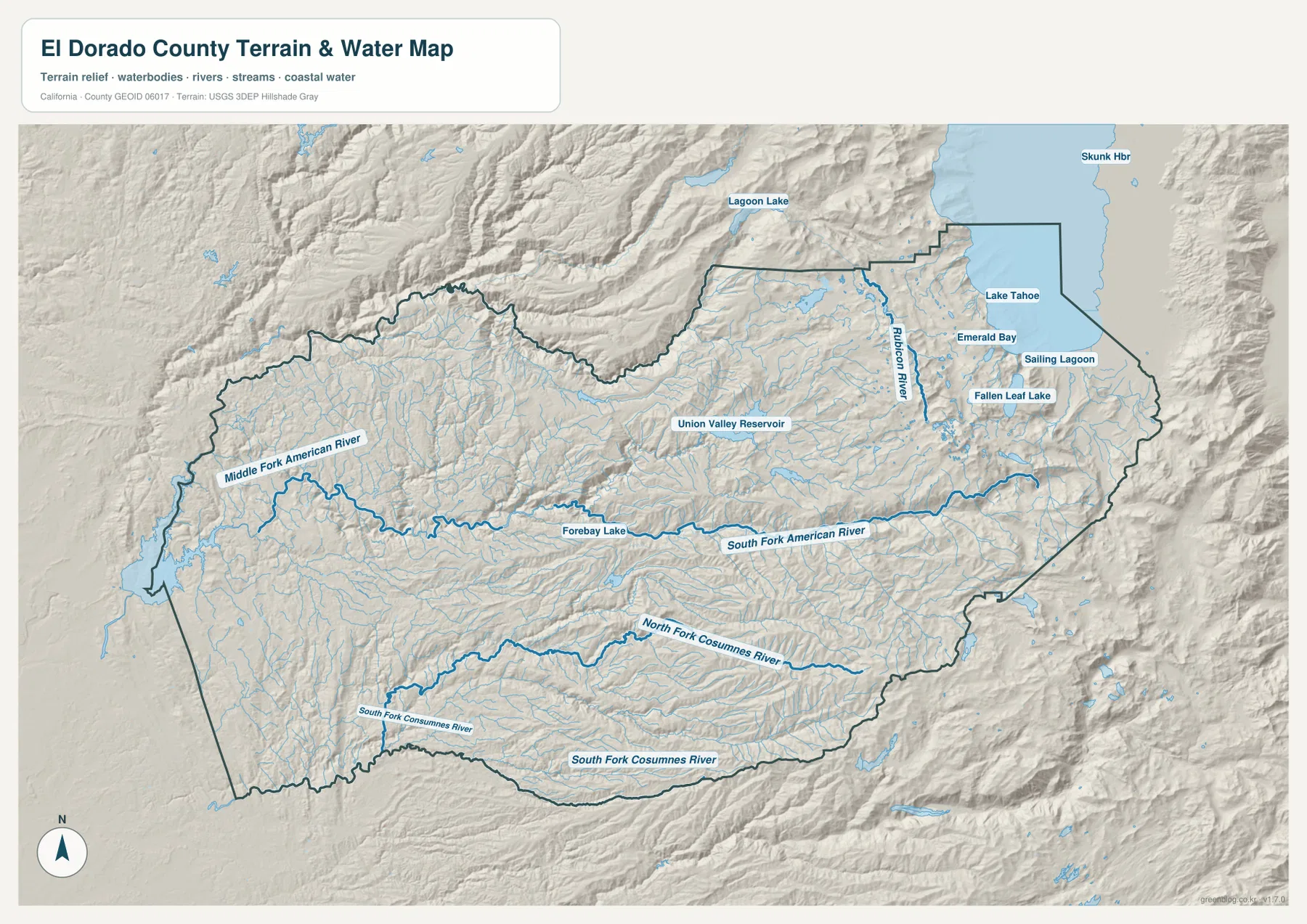
Union Valley Reservoir is another major feature in the north-central mountains. It sits far from the county’s largest developed areas and is surrounded by a dense network of streams and ridges. Comparing the water map with the reference map makes clear how much of central El Dorado County is mountain watershed rather than town-centered landscape.
The Middle Fork American and Cosumnes rivers define separate mountain drainages
North of the South Fork, the Middle Fork American River is labeled across the western and northwestern mountain side. Georgetown and Auburn Lake Trails lie closer to this part of the county than the communities along U.S. 50. The river and its tributaries help divide the northern foothills into a different set of valleys from the central South Fork corridor.
To the south, the North Fork Cosumnes River and South Fork Cosumnes River occupy long drainages below the main American River system. Grizzly Flats lies north of part of this southern watershed, and numerous smaller streams descend toward the Cosumnes forks. Seeing these separate river basins explains why the county’s road network cannot be reduced to a single east–west highway even though U.S. 50 is the most obvious route.
This terrain-and-water image is a county-scale geographic reference rather than a flood-hazard, parcel, rafting-safety, or water-quality map. Use it to locate river valleys, reservoirs, and lake features in relation to communities and roads. Current safety or property decisions require information from the agencies that manage those specific waterways and lands.
The Lake Tahoe Basin forms a distinct eastern part of the county
El Dorado County’s official profile divides the county into two broad geographic zones: the Western Slope and the Lake Tahoe Basin. The supplied maps make that separation easy to see. Placerville, Camino, and Pollock Pines belong to the western-slope settlement pattern; after a long mountain section, Meyers and South Lake Tahoe appear in a separate basin at the eastern end.
Lake Tahoe dominates the eastern water map, with Emerald Bay and Fallen Leaf Lake labeled nearby. The Rubicon River occupies high mountain terrain west of the lake, and many smaller lakes and streams fill the surrounding Sierra. This end of the county has far fewer roads and developed areas than the lower western slope, but much larger mountain and water features.
South Lake Tahoe sits on the south shore of Lake Tahoe, while Meyers lies west of the city near the U.S. 50 and Highway 89 corridor. Highway 89 continues through the Tahoe side, and Highway 88 is labeled near the southern mountain boundary. These roads provide important references in a region where large ridges and lake basins occupy much more space than urban streets.
Relief rises dramatically from the western foothills toward the Sierra crest
There is no separate elevation map in this package, but the terrain shading clearly shows a major increase in ruggedness from west to east. A recent El Dorado County profile describes the Western Slope as beginning with rolling foothills and agricultural land near Sacramento County and rising across the Sierra Nevada toward the high Lake Tahoe Basin. The county’s own geographic division reflects this large physical transition.
El Dorado Hills and Cameron Park occupy comparatively gentle western terrain. East of Placerville, stream valleys and ridges become more closely spaced, and beyond Pollock Pines the U.S. 50 corridor is enclosed by much more rugged mountains. Around Lake Tahoe, steep ridges, large lakes, and dense alpine drainage dominate the map. Precise elevation work requires dedicated USGS elevation data; the supplied relief image is best used for broad visual comparison.
Following US 50 from Placerville is the simplest way to organize the county
A first-time reader can begin at Placerville and follow U.S. 50 in both directions. Westward, Diamond Springs, Cameron Park, and El Dorado Hills lead toward the Sacramento side. Eastward, Camino and Pollock Pines mark the last major western-slope communities before the route enters a long Sierra mountain section and eventually reaches Meyers and South Lake Tahoe.
Next, switch to the terrain map and trace the South Fork American River through the central mountains. The Middle Fork American River and Union Valley Reservoir provide northern reference points, while the Cosumnes forks organize the south. Finally, Lake Tahoe, Emerald Bay, and the Rubicon River make the eastern basin easy to distinguish from the rest of the county.
Choose the file according to whether you need roads, municipalities, or mountain water features
The county reference map is the best starting point for Placerville, El Dorado Hills, Coloma, Pollock Pines, South Lake Tahoe, highways, nearby counties, and the boundary. The city graphic gives a clean comparison of the two incorporated cities. The terrain-and-water image provides the strongest view of the American River system, Union Valley Reservoir, Rubicon River, Lake Tahoe, and the mountain valleys between the western slope and Tahoe Basin.
For teaching or regional explanation, the reference and terrain maps work especially well together. Placerville and Coloma can be connected with Highway 49 and the South Fork American River, while the U.S. 50 corridor illustrates the long climb from the populated western slope into Sierra mountain country. South Lake Tahoe then provides a clear endpoint in a separate lake basin at the Nevada side of the county.
Each downloadable JPG measures 3638 × 2572 pixels and is suitable for A3 landscape printing, enlarging small place labels, or placing a map in a report or classroom handout. Keep the original aspect ratio when resizing so roads, waterways, and the county outline are not distorted. Printer margins vary, so checking one test page before a larger print run is useful.
Frequently Asked Questions
What is the county seat of El Dorado County?
Placerville is the county seat. It lies on the western slope near U.S. 50 and Highway 49 and serves as a practical map reference between the lower foothill communities to the west and the Sierra corridor to the east.
How many incorporated cities are in El Dorado County?
El Dorado County’s official profile identifies two municipalities: Placerville and South Lake Tahoe. The supplied city-distribution map shows the same two cities at opposite ends of the county.
Does this download include a separate elevation map?
No. This package contains the county reference map, city-distribution map, and terrain-and-water map. Relief shading shows the large difference between the western foothills and the Sierra/Lake Tahoe Basin, but no separate numeric elevation map is included.
Map File Information
The ZIP contains the original El Dorado County reference, city-distribution, and terrain-and-water maps as high-resolution JPG files.
- Included Files: County reference map, city-distribution map, terrain-and-water map
- Printable Size: 3638 × 2572 pixels each
- File Type: Three high-resolution JPG files in one ZIP archive
Related Maps
Sources and References
- El Dorado County – About Us – Official information on Placerville, South Lake Tahoe, the Western Slope, and the Lake Tahoe Basin.
- El Dorado County Parks – Rivers – Official county information on the managed South Fork American River corridor.
- El Dorado County Adopted General Plan – Official county planning and map resources for land use and transportation.
- California State Parks – Marshall Gold Discovery State Historic Park – Official background on Coloma and the 1848 gold discovery along the South Fork American River.
- USGS National Hydrography – Official U.S. river, stream, lake, and hydrographic data information.
Green Map creates custom-edited map images using open geographic data sources such as geoBoundaries, Natural Earth, OpenStreetMap, and government open data.
These maps are edited visual materials, not raw data files, and are provided for education, documents, presentations, and graphic reference.