Union County occupies the far southeastern corner of South Dakota, where the county narrows from the Alcester area in the north toward Elk Point, Jefferson, North Sioux City, and Dakota Dunes in the south. Its shape is strongly influenced by water: the Big Sioux River forms the winding eastern edge and the Missouri River bends along the southern end. The supplied maps place those river boundaries beside roads, communities, tributary creeks, and a countywide elevation surface, making it much easier to see how the northern uplands differ from the lower southeastern river country. The same four original A3 high-resolution JPG maps used on this page can be downloaded together from the map file box below.
U.S. Census Bureau QuickFacts lists 16,811 residents in the 2020 Census, 460.76 square miles of land, and a 2020 density of 36.5 people per square mile in Union County. That density helps explain why the map shows a more closely connected set of towns and transportation routes than many larger rural counties farther west in South Dakota. The official Union County website identifies Elk Point as the county seat and describes the area’s long relationship with the Missouri and Big Sioux Rivers. Those facts are useful background for reading a county where both settlement and the boundary itself are closely tied to major river corridors.
Table of Contents
A long county framed by the Big Sioux River on the east and Missouri River on the south
The county is broader in the north and becomes progressively narrower toward its southern end. Alcester is near the north-central area, while Richland appears farther south in the eastern half. Elk Point occupies the middle-southern part of the county, Jefferson lies below it, and North Sioux City and Dakota Dunes are close to the southeastern tip. Burbank is labeled just beyond the western side, helping place the county in relation to nearby communities outside its boundary.
The eastern boundary is easy to recognize because it rarely follows a straight line. Instead, it bends with the Big Sioux River along the South Dakota-Iowa border. The southern edge curves even more broadly around the Missouri River. North Sioux City and Dakota Dunes sit close to the meeting of these two major river corridors, while Alcester is far to the north in a more elevated inland setting. That north-south contrast is one of the most useful ideas to keep in mind when comparing the four supplied maps.
Elk Point’s role as the county seat also makes geographic sense on the general map. It is not at either extreme of the county but lies between the northern communities and the North Sioux City area. Jefferson occupies the next important position farther south, while Richland sits to the north of Elk Point. The sequence of these places emphasizes how strongly Union County is organized along a long north-south corridor.
I-29 connects Elk Point, Jefferson, and North Sioux City while east-west highways cross the interior
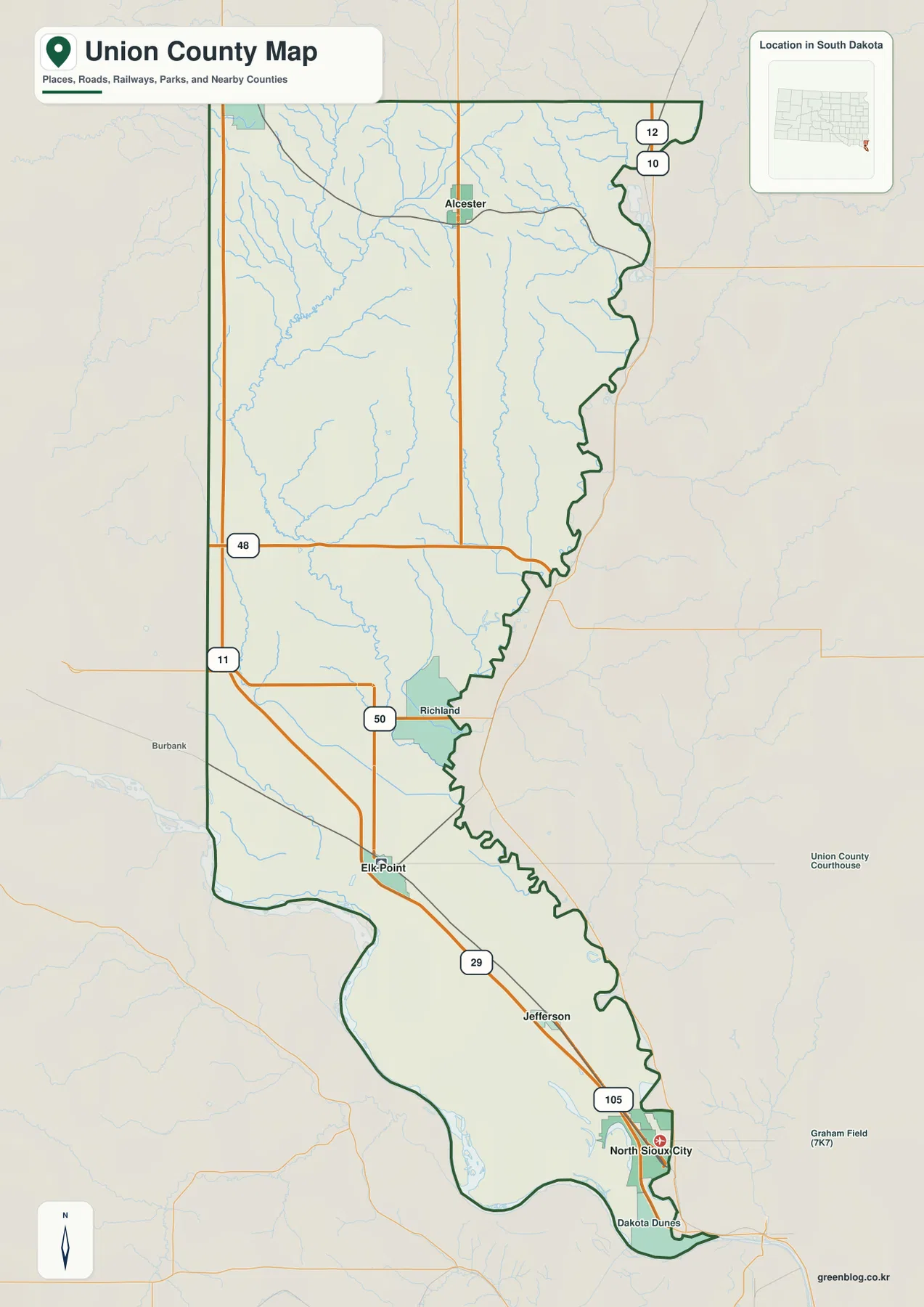
Interstate 29 is the most important road for understanding the southern half of the county. It passes through the Elk Point-Jefferson corridor and continues toward North Sioux City, following the same general north-south direction as the county’s narrow southern section. Near North Sioux City, SD 105 provides another local connection. Farther north, SD 50 crosses the interior near Richland, linking the central county with roads beyond the river-side communities.
SD 48 runs east-west across the middle-northern part of the county, while SD 11 is shown near the western side. Around Alcester, additional north-south roads connect the northern agricultural area with the rest of Union County. These routes create a different pattern from the I-29 corridor: the north has more broadly spaced rural roads, while the south has a stronger linear connection through Elk Point, Jefferson, and North Sioux City.
A railroad line also follows much of the southern corridor, passing through Elk Point and Jefferson toward North Sioux City. Another rail segment is visible near Alcester. The transportation layers therefore reinforce what the settlement pattern already suggests: several of the county’s main communities developed along north-south travel routes. The map is a reference for orientation rather than live navigation, so current road conditions and closures should still be checked with transportation agencies.
Five ranked cities are split between the northwest and the I-29 corridor
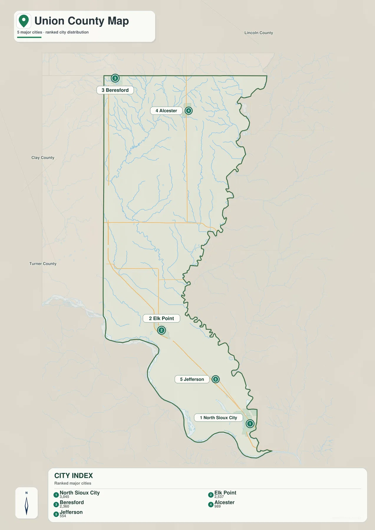
The ranked city layer displays five selected places: North Sioux City at 3,045, Elk Point at 2,537, Beresford at 2,360, Alcester at 989, and Jefferson at 554. These are the values used in the supplied map’s city index and should not automatically be interpreted as the newest population estimates. The layer is most useful for seeing where the selected cities sit in relation to one another.
North Sioux City and Elk Point are both in the southern half, with Jefferson positioned between them along the broader I-29 corridor. Beresford appears at the northwestern county edge, well separated from the southeastern cities, while Alcester lies near the northern interior. The three highest indexed places therefore do not form one compact cluster. Union County has a distinct northern or northwestern group and a more strongly connected southern group.
The city map is deliberately narrower than the general county map. Richland and Dakota Dunes, for example, appear on the broader reference map but are not numbered on this layer. An unnumbered place should not be treated as outside the county or unimportant. Use the city map for a simplified comparison of the five selected communities and the general map when roads, additional settlements, and boundary details matter.
Brule Creek and Union Creek tributaries descend toward the two major river borders
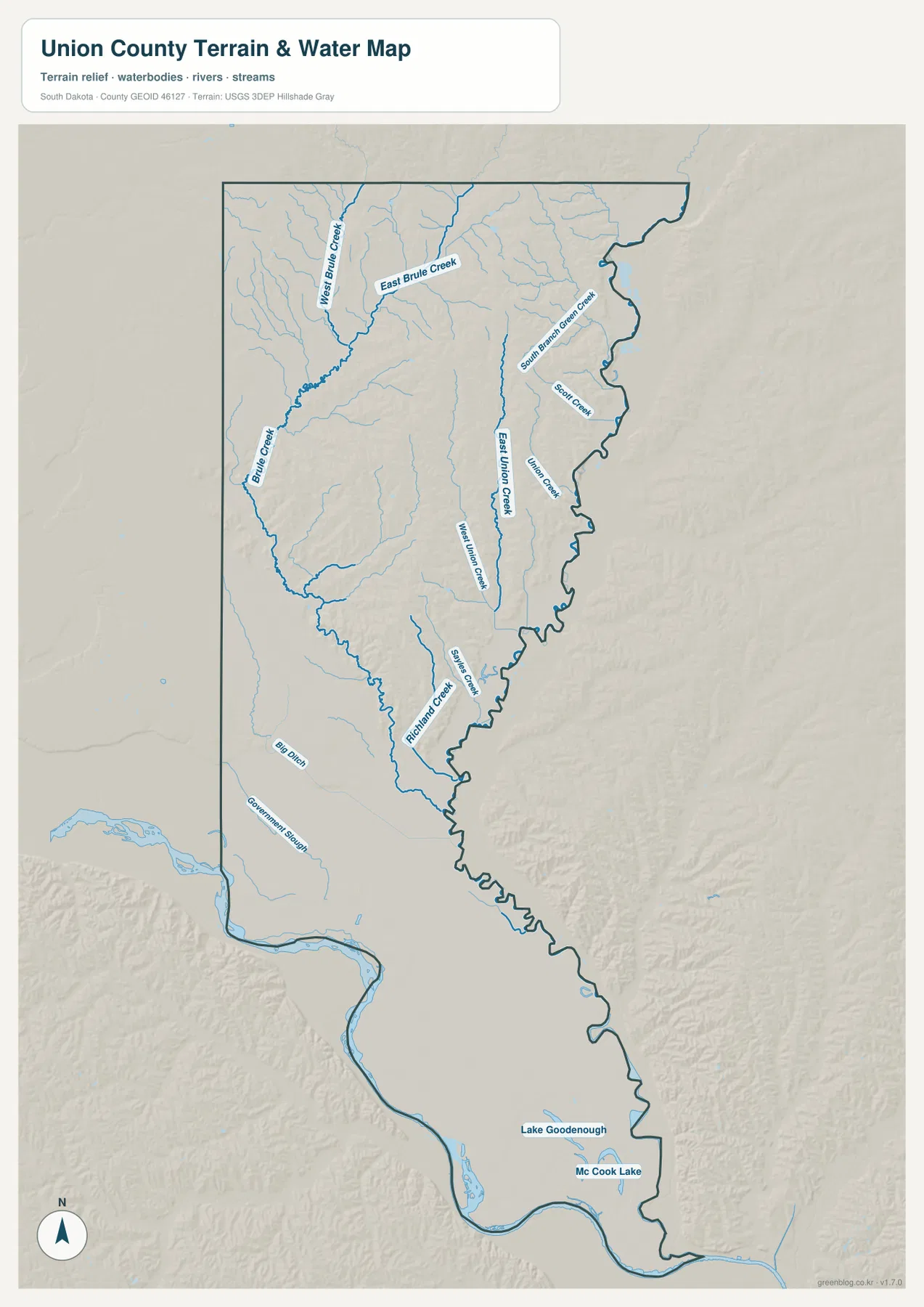
The water map reveals a dense creek network in the northern and central parts of Union County. West Brule Creek and East Brule Creek are labeled in the northwest and feed into the broader Brule Creek system. South Branch Green Creek and Scott Creek appear farther east. In the central-eastern portion, East Union Creek and Union Creek run in long north-south channels, adding a second major group of named tributaries.
Farther south, West Union Creek and Richland Creek continue the pattern of narrow valleys moving toward the lower river country. Big Ditch and Government Slough are labeled in the southwest. Near the southeastern end, Lake Goodenough and McCook Lake provide clear water landmarks close to North Sioux City. The Big Sioux River along the east and Missouri River along the south dominate the outer boundary, while the smaller interior creeks show how water drains through the county toward those lower corridors.
This is a geographic water-reference map, not a flood-hazard or navigation product. It does not provide flood probabilities, current river stages, water quality, property ownership, fishing rules, or legal access. Anyone making a safety or land-use decision near the Big Sioux River, Missouri River, or McCook Lake should use current USGS and relevant state or local information rather than relying on this simplified map alone.
Elevation drops from the northwestern uplands toward the Big Sioux and Missouri lowlands
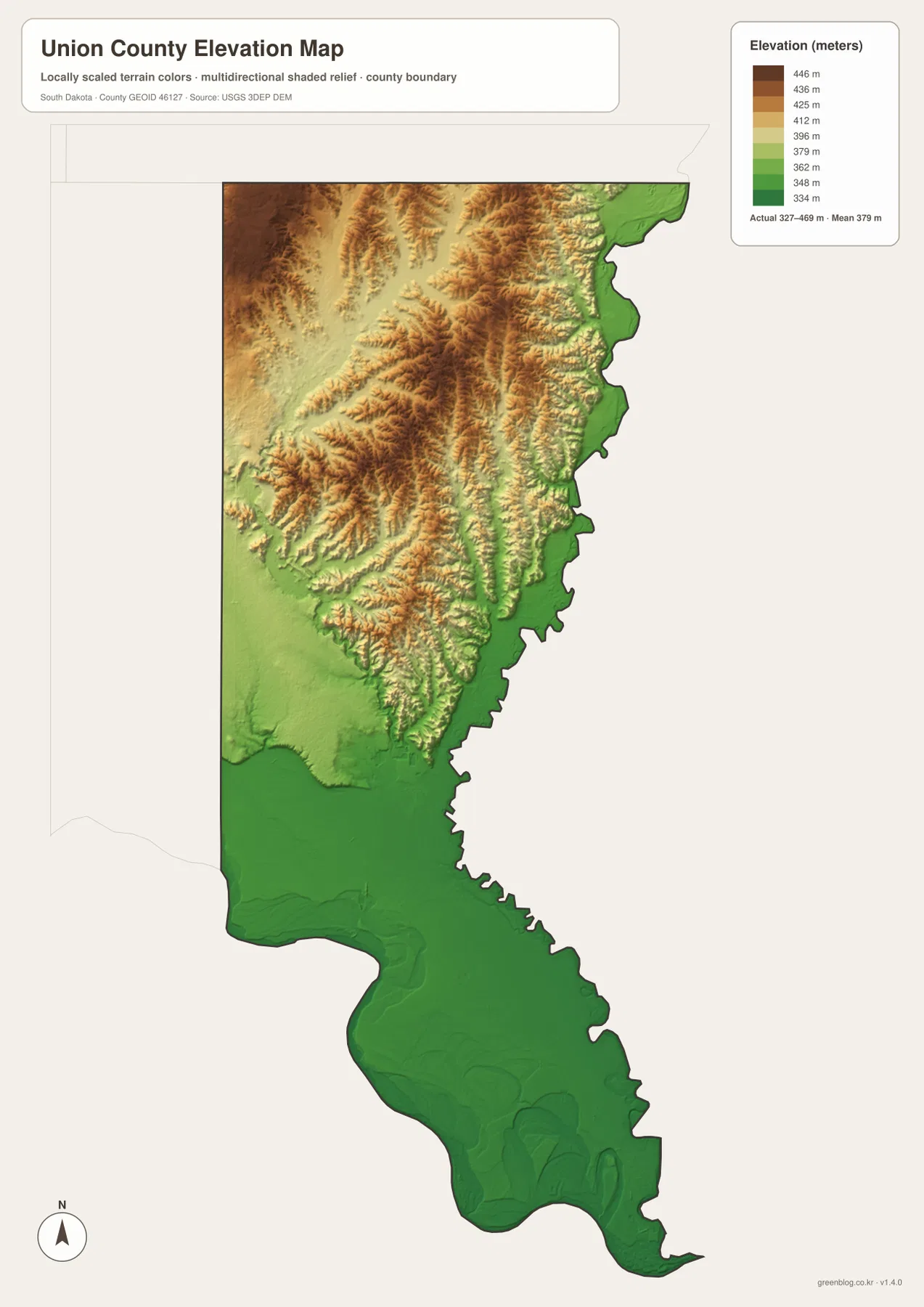
The elevation legend gives an actual mapped range of about 327 to 469 meters, with a mean near 379 meters. The strongest brown tones occupy the northwestern and north-central uplands, where a series of ridges and rolling high areas create much more relief than the southern end of the county. Along the eastern boundary, green colors form a narrow low strip beside the Big Sioux River. The Missouri River corridor in the south is also broadly lower.
Brule Creek and Union Creek valleys cut through the higher northern terrain as narrow green channels. Moving south from Elk Point, the broad brown uplands become less common, and lower green terrain dominates around North Sioux City and Dakota Dunes. This creates a clear physical contrast within a relatively small county: the north and northwest are rolling and elevated, while the southeastern river country is lower and flatter.
The elevation surface is a generalized countywide reference derived from USGS 3DEP data. It is useful for broad comparisons of relief and for explaining why creek valleys and major river borders occupy lower ground, but it is not survey-grade or engineering-grade measurement. Construction, drainage design, levee work, and property-level elevation decisions require original elevation data and site-specific professional measurements.
Choose the road map for orientation and the water or elevation maps for the river landscape
For basic orientation, start with the general county map. It places Alcester, Elk Point, Jefferson, North Sioux City, and the main roads in one frame. The ranked city layer is cleaner when the goal is to compare the five selected places. The water map is the better choice for Brule Creek, Union Creek, Government Slough, and McCook Lake, while the elevation map shows why the northwestern uplands stand well above the Big Sioux and Missouri River corridors.
The WebP images on the page are optimized for quick viewing. The ZIP archive contains the original 2572×3638-pixel JPG versions of the general county map, ranked city map, terrain-and-water map, and elevation map. They are more suitable for A3 printing, zooming into small creek and road labels, classroom materials, presentations, and personal geographic reference. Legal boundaries, surveying, flood safety, and live travel decisions still require current official purpose-specific data.
Frequently Asked Questions
Is Elk Point the county seat of Union County?
Yes. The official Union County website identifies Elk Point as the county seat. On the general map, it also occupies a useful middle position between the northern communities and the North Sioux City area.
Why are the eastern and southern county boundaries so irregular?
The eastern edge follows the Big Sioux River and the southern end follows the Missouri River. Because both rivers curve, the county boundary bends with them rather than forming straight survey lines. Comparing the general and water maps makes this relationship easy to see.
Can the 327–469 meter elevation range be used for surveying?
No. The range is intended for broad countywide comparison. It clearly shows higher northern uplands and lower river corridors, but survey, construction, drainage, or property-level work requires original USGS 3DEP data and professional site measurements.
Map File Information
The archive contains the Union County general map, ranked city map, terrain-and-water map, and elevation map as original high-resolution A3 JPG files.
- Included Files: 4 JPG maps
- Printable Size: 2572×3638 pixels each
- Intended Use: A3 printing, education, presentations, and geographic reference
Related Maps
Sources and References
- Union County, South Dakota: official county overview, Elk Point county-seat information, and local history
- U.S. Census Bureau QuickFacts – Union County, South Dakota: population, land area, and population-density reference
- South Dakota Department of Transportation – Maps: official state and county transportation map resources
- U.S. Census Bureau TIGER/Line Shapefiles: official county boundary and geographic data
- USGS National Hydrography: river, lake, and stream reference data
- USGS 3D Elevation Program: elevation-data reference for the county elevation map
Green Map creates custom-edited map images using open geographic data sources such as geoBoundaries, Natural Earth, OpenStreetMap, and government open data.
These maps are edited visual materials, not raw data files, and are provided for education, documents, presentations, and graphic reference.