The Huerfano County Colorado Land Cover Map shows a strong contrast between broad eastern grassland and the forest-and-shrub mountain country around the Spanish Peaks. Grassland covers 38.60%, shrubland 32.75%, and forest 23.83%, while the largest developed patches remain concentrated near Walsenburg and La Veta.
This article compares current land cover, forest and farmland, impervious surfaces, and mapped differences from 1985 to 2025. Four original JPG maps are packaged in one ZIP near the end of the page for printing, classroom work, presentations, and detailed side-by-side viewing.
Table of Contents
Walsenburg sits where concentrated development meets the eastern grasslands
The east-central portion contains the county’s largest developed cluster. Huerfano County government is based in Walsenburg, and Colorado Parks and Wildlife places Lathrop State Park about three miles west of town. Those verified reference points make this cluster easier to locate on the current and impervious maps.
Outside the settlement area, the red developed class drops away quickly and pale grassland becomes dominant. Thin road-like traces continue across the east, but no broad urban surface spreads across the prairie. This concentration helps explain why developed cover is only 1.90% countywide.
At 38.60%, grassland is the largest 2025 class. It forms the background for much of eastern Huerfano County, interrupted by shrub patches, wetland traces, tiny agricultural areas, and narrow developed lines. The east is open, but it is not a featureless single-color surface.
Wetlands account for 1.85%, much more than the 0.09% water share. Their blue-green pixels often follow narrow drainage-like paths through both grassland and mountain terrain. Those cells provide broad environmental context rather than legal wetland boundaries.
The 2025 map shows the full transition from prairie to Spanish Peaks forest
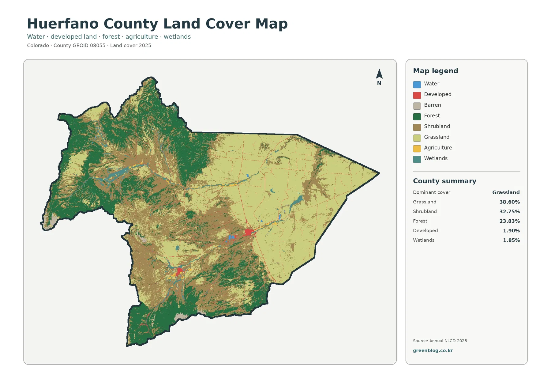
The current map is the best single view for understanding Huerfano County. Pale grassland dominates the east, shrubland expands through the center and foothills, and dark forest becomes much more extensive through the west and southwest.
Shrubland covers 32.75%, nearly as much as grassland. Its broad tan areas occupy much of the transition between open prairie and forested mountains, showing that the western half is not simply continuous forest.
Forest makes up 23.83% and is strongly concentrated toward Spanish Peaks country. Huerfano County’s official website uses that regional identity, which fits the visible difference between western mountain cover and the open eastern side.
Agriculture is only 0.37%. Small yellow or pasture-colored patches appear in limited open areas, but most of the eastern landscape is grassland rather than cropland. That distinction prevents an open-looking surface from being mistaken for a large agricultural district.
La Veta is a mountain-edge settlement with forest and shrubland close by
A second, smaller developed cluster appears south of the Walsenburg area. The Town of La Veta places the community east of La Veta Pass through the Sangre de Cristo Mountains and at the northern opening of the Cuchara River Valley.
That setting is visible in the surrounding cover. Development near La Veta sits much closer to forest and shrubland than the Walsenburg cluster does. Moving west from the town, forest increases quickly; moving east, open grass and shrub cover become more important.
The town’s description mentions ranching as part of local life, but that should not be used to label individual NLCD pixels as farms. Land cover describes surface conditions at raster scale, while ranch boundaries and actual land use require parcel or agricultural data.
Pale openings in the western mountains also represent more than one class. Grassland, shrubland, and barren-looking surfaces can occur next to each other, so the detailed legend remains important when explaining mountain cover.
The simplified map makes the west–east vegetation contrast easier to explain
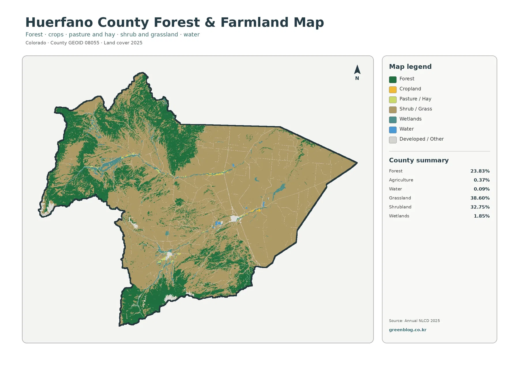
With fewer legend classes, western forest forms a clear dark-green region while shrub-and-grass cover dominates the center and east. Forest is less than one-quarter of the county overall, but its western concentration makes it locally dominant.
Agricultural cover remains minor. Small cropland and pasture colors appear around selected open areas near the settlements and farther east, but they never create a continuous farm belt. The main value of this map is the forest-versus-open-cover comparison.
Walsenburg and La Veta also look different on this simplified layer. Walsenburg is surrounded largely by open grass and shrub cover, while La Veta lies closer to forest. The contrast makes the relationship between settlement and surrounding vegetation easier to explain.
Forest-colored cells should not be treated as public-land or conservation boundaries. Surface cover and administrative ownership are separate datasets, even when both describe the same mountain area.
Martin Lake and Horseshoe Lake provide local water references near Walsenburg
Colorado Parks and Wildlife identifies Martin Lake and Horseshoe Lake at Lathrop State Park just west of Walsenburg. Those named lakes are useful reference points even though open water covers only 0.09% of Huerfano County.
Concentration explains the apparent mismatch between the small percentage and local visibility. A few compact lakes can be meaningful on the map without contributing much to total county area. Tiny water features elsewhere may disappear almost completely at web-preview scale.
Wetlands are much more extensive than open water and often follow narrow valley or drainage patterns. Comparing the water and wetland classes separately gives a more accurate picture of where moisture-related cover appears across both grassland and mountain terrain.
The state-park page and NLCD answer different questions. The park source provides names and recreation context; the raster map provides generalized 2025 surface classes. Keeping those purposes separate prevents a named lake from being confused with the entire water category.
Only a few settlement clusters rise above Huerfano County’s 0.33% mean imperviousness
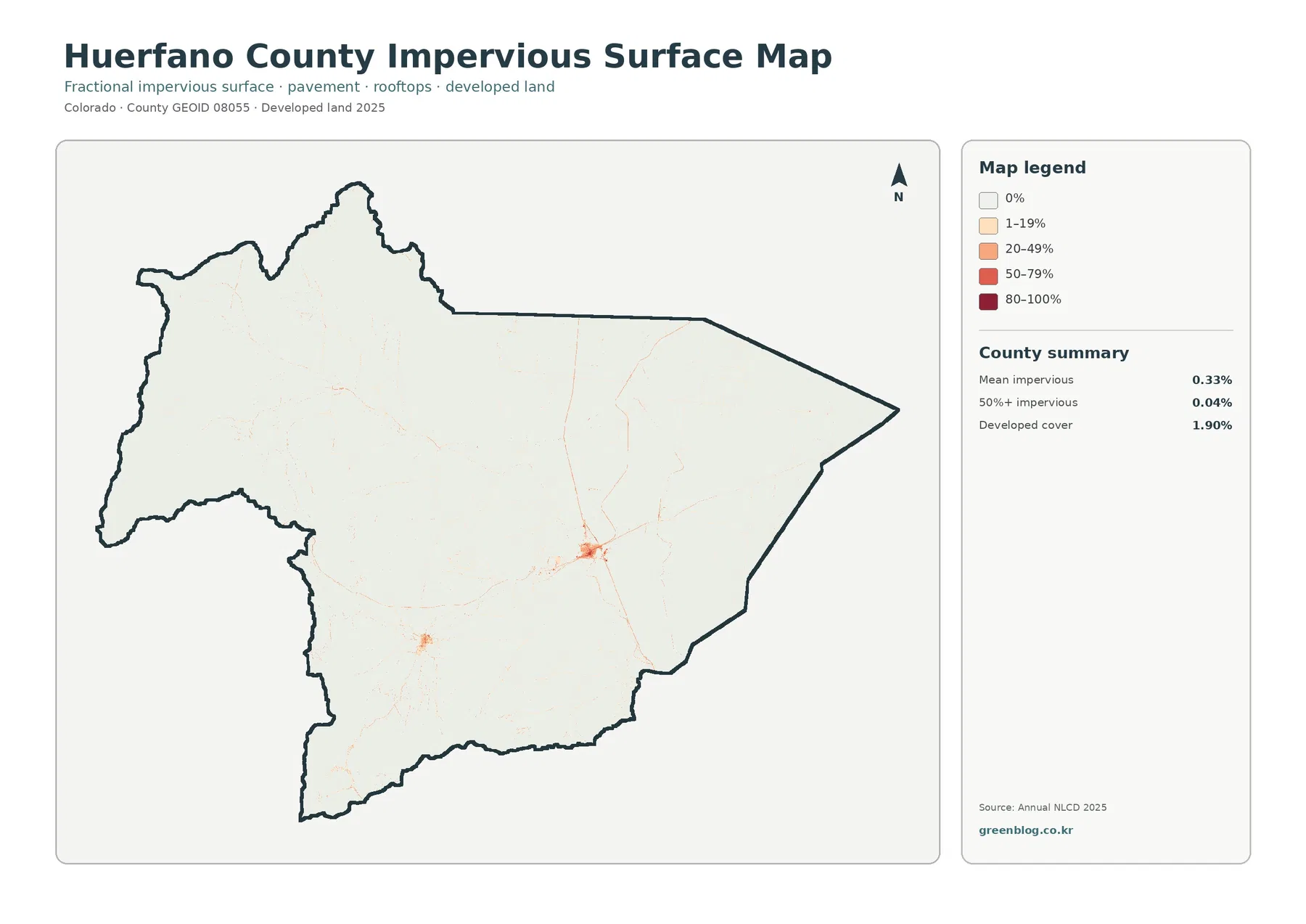
Mean imperviousness is 0.33%, and cells mapped at 50% or greater imperviousness cover just 0.04% of the county. Most of the map is nearly white because grassland, shrubland, and forest occupy far more area than pavement and buildings.
The darkest cluster lies around Walsenburg, where orange and red cells group together and thin linear features extend outward. La Veta forms a second, smaller concentration. These locations match the broad settlement pattern without turning the entire county into an urban landscape.
Developed land cover is 1.90%, which is not the same measure as mean imperviousness. The land-cover product assigns categorical developed classes, whereas fractional imperviousness estimates the share of hard surface inside each cell.
Mountain and rural settlements often contain homes and roads surrounded by trees, grass, and soil. That mixture allows a cell to be classified as developed without having a high impervious percentage.
The 1985–2025 change map is much busier in the western mountain country
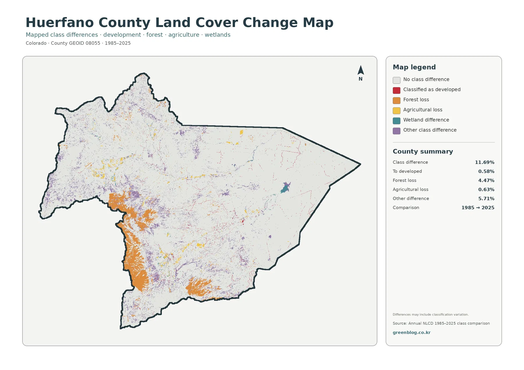
Mapped classes differ across 11.69% of Huerfano County between 1985 and 2025. Other class difference is the largest category at 5.71%, followed by forest loss at 4.47%, agricultural loss at 0.63%, and conversion to developed at 0.58%.
Orange forest-loss patches are most prominent in the southwest and south, with additional areas throughout the western mountain country. Current forest and forest loss can occupy the same general region, but they are not the same statistic.
Purple other-difference pixels are spread widely through the west and center. Because classification variability can contribute to this category, isolated pixels should not be assigned a physical cause without intermediate-year imagery or local records.
Red conversion-to-developed cells remain limited and appear mainly around existing settlements and a few narrow routes. The 0.58% conversion category does not represent the entire present developed footprint.
Use three reference areas to compare all four maps without mixing their meanings
Walsenburg is the best anchor for built-surface questions. Current land cover shows the broader developed class, imperviousness isolates harder surfaces, and Lathrop State Park adds a nearby named water reference.
La Veta is more useful for seeing how settlement meets forest and shrubland. The surrounding mountain cover changes quickly, making it a good contrast with Walsenburg’s grassland setting.
The Spanish Peaks side is the strongest reference for forest and long-term class change. Comparing current forest with orange forest-loss patches shows why the change layer should never be treated as a replacement for the current land-cover map.
Annual NLCD uses 30-meter raster cells, so narrow roads, small lakes, and fine wetland traces can appear differently at different zoom levels. Use the maps for county-scale patterns rather than parcel boundaries or engineering measurements.
Download four original Huerfano County land-cover JPG maps
The ZIP contains four JPG files: general land cover, forest and farmland, impervious/developed land, and 1985–2025 land-cover change. Because all four use the same county boundary, it is easy to compare Walsenburg, La Veta, and the Spanish Peaks region across different layers.
Keep the title, year, and legend with each map when reusing it. Current development and imperviousness, or current forest and forest loss, describe different measurements and should not be labeled as though they were interchangeable.
Frequently Asked Questions
Where are grassland and forest most concentrated in Huerfano County?
Grassland is broadest across the eastern half, while forest is concentrated in the west and southwest around Spanish Peaks country. Shrubland forms much of the transition between those two settings.
Are there notable lakes even though water covers only 0.09%?
Yes. Martin Lake and Horseshoe Lake are located at Lathrop State Park west of Walsenburg. Their compact location makes them locally useful map references despite the small countywide water share.
Can 4.47% forest loss be subtracted from the current 23.83% forest share?
No. Forest loss is a 1985–2025 change category, while 23.83% describes current 2025 forest cover. They are different measurements and cannot be subtracted to reconstruct an earlier forest percentage.
Map File Information
The downloadable archive contains four original Huerfano County land-cover JPG maps.
- Included Files: Use only the versions confirmed in the article and supplied images
- File Type: Use the confirmed download contents
- Intended Use: Printing, education, presentations, and map-based projects
Related Maps
- Adams County Colorado Land Cover Map
- Alamosa County Colorado Land Cover Map
- Arapahoe County Colorado Land Cover Map
Sources and References
- MRLC Annual NLCD Data – official access point for Annual NLCD products and data.
- USGS Annual NLCD Land Cover Classification – official documentation for interpreting Annual NLCD classes and 30-meter raster data.
- Huerfano County Government – official county information and the county’s Spanish Peaks Country identity.
- Town of La Veta – About Us – official geographic context for La Veta Pass, the Sangre de Cristo Mountains, and the Cuchara River Valley.
- Colorado Parks and Wildlife – Lathrop State Park – official information about Martin Lake, Horseshoe Lake, and the park’s location west of Walsenburg.
Green Map creates custom-edited map images using open geographic data sources such as geoBoundaries, Natural Earth, OpenStreetMap, and government open data.
These maps are edited visual materials, not raw data files, and are provided for education, documents, presentations, and graphic reference.