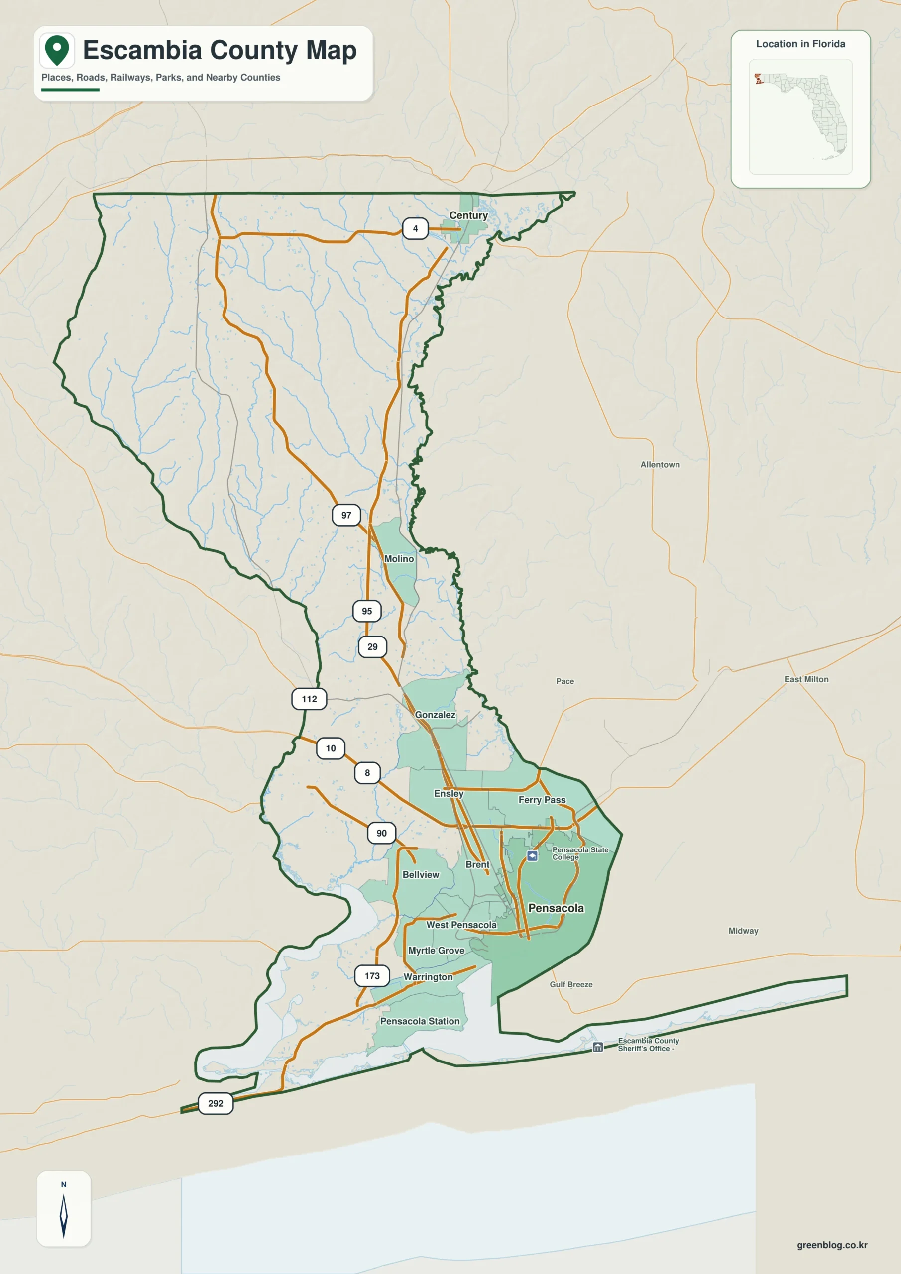
An Escambia County Florida map is easiest to read as two connected landscapes: the Pensacola Bay urban coast in the south and a long inland corridor reaching Century at the Alabama line. US 29 ties those areas together, while the Perdido River and bay define the western side and the Escambia River–Pensacola Bay system organizes the east and southeast.
Download the Escambia County map
- Map file: County reference map
- File format: ZIP
Table of Contents
Quick Facts
- State: Florida
- County: Escambia County (FIPS 12033)
- County seat: Pensacola
- 2020 population: 321,905
- 2020 land area: 656.99 square miles
- Incorporated municipalities: Pensacola and Century
- Key communities: Ferry Pass, Brent, Bellview, Warrington, Cantonment, and Molino
- Main roads: I-10, I-110, US 29, US 90, US 98, and SR 292
- Defining waters: Pensacola Bay, Escambia River and Bay, Perdido River and Bay, Gulf coast
The 2020 Census counted 321,905 residents on 656.99 square miles of land. Most continuous development occupies the southern Pensacola area, but the county extends north through Cantonment and Molino to Century. That elongated shape makes the north–south road network as important as the coastline when locating communities.
What the Map Shows
Pensacola, the county seat, sits on the northwest side of Pensacola Bay. Port facilities occupy the downtown waterfront, Naval Air Station Pensacola lies southwest of the central city, and the larger urban area spreads beyond the city limits through Warrington, Bellview, Brent, Ensley, and Ferry Pass. Those community names distinguish the actual metropolitan pattern from the much smaller incorporated city outline.
US 29 leads north from the Pensacola area through Cantonment and Molino before reaching Century. Century is not simply a distant neighborhood; it is the county’s second incorporated municipality and stands just south of the Alabama state line. Reading these places in order reveals the county’s inland spine and the large gap between its coastal and border communities.
The two best-known beach areas occupy different barrier islands. Pensacola Beach is on Santa Rosa Island east of the bay entrance, while Perdido Key lies southwest of Pensacola and continues across the Florida–Alabama boundary. Pensacola Bay, the naval station peninsula, Big Lagoon, and mainland neighborhoods separate them, so their labels should never be treated as adjacent points on one island.
County Layout and Location
Escambia is Florida’s westernmost county. Santa Rosa County lies east, and Alabama borders the west and north. The Perdido River forms the Florida–Alabama line for much of the western edge before entering Perdido Bay. On the opposite side, the Escambia River descends from Alabama toward Escambia Bay, which opens southward into the larger Pensacola Bay system.
I-10 crosses southern Escambia from Alabama to Santa Rosa County. I-110 branches south from it and ends near downtown Pensacola, while US 29 provides the principal inland route from the urban area to Century. Together, these three highways separate regional east–west travel, downtown access, and the long north–south county connection.
US 90 crosses northern Pensacola and continues east and west; US 98 serves the downtown–Warrington corridor and crosses Pensacola Bay into Gulf Breeze. The road approach to Pensacola Beach is geographically unusual: drivers cross into Santa Rosa County on US 98, turn south in Gulf Breeze, and then use the Bob Sikes Bridge to re-enter Escambia County on Santa Rosa Island. SR 292, by contrast, runs southwest toward Perdido Key and continues along the island to the Alabama line.
Local Context
Pensacola Bay links several features that appear separate on a simplified road diagram. The Port of Pensacola is on the downtown waterfront, Naval Air Station Pensacola occupies the western side of the bay entrance, and Fort Pickens stands across the channel at the western end of Santa Rosa Island. The bay is therefore a transportation corridor, an urban edge, and a physical divider at the same time.
Gulf Islands National Seashore protects areas on both Santa Rosa Island and Perdido Key. Developed Pensacola Beach occupies part of county-owned Santa Rosa Island, while the Fort Pickens district extends west toward the bay entrance. The national seashore’s Perdido Key area lies on a separate island near Big Lagoon. Recognizing those two park areas clarifies why protected dunes interrupt otherwise developed coastal strips.
Inland settlement changes noticeably north of I-10. Cantonment and Molino serve as intermediate points along the US 29 corridor, and Century anchors the state-line end. Development is more dispersed between these communities, with the Perdido and Escambia river lowlands influencing where roads and settlements can extend. On an Escambia County Florida map, that linear inland pattern is as distinctive as the compact urban coast.
Ways to Use This Map
- Trace the state line: follow the Perdido River and Perdido Bay along Florida’s western edge.
- Read the inland sequence: use US 29 to place Pensacola, Cantonment, Molino, and Century from south to north.
- Locate downtown: follow I-110 south from I-10 rather than assuming Pensacola lies near the county center.
- Separate the beaches: identify Pensacola Beach on Santa Rosa Island and Perdido Key on the western barrier island.
- Follow the estuaries: distinguish the Escambia River–Pensacola Bay system from the Perdido River–Perdido Bay system.
- Continue east: align I-10, US 90, and US 98 with the adjacent Santa Rosa County map.
Frequently Asked Questions
Why is Century so far from Pensacola?
Escambia County runs a long distance north from Pensacola Bay to the Alabama line. Century is near that northern boundary, while Pensacola occupies the southern bay shore. US 29 is the direct geographic link between them, passing Cantonment and Molino along the way.
Are Pensacola Beach and Perdido Key on the same barrier island?
No. Pensacola Beach occupies Santa Rosa Island east of the Pensacola Bay entrance. Perdido Key is a separate barrier island southwest of the city, south of Big Lagoon, and it crosses the Florida–Alabama line. Gulf Islands National Seashore has distinct areas on both islands.
Sources
- U.S. Census Bureau QuickFacts — Escambia County
- Florida Department of Transportation — I-10 interchanges
- Florida Department of Transportation — I-110 interchanges
- Escambia County — Pensacola Beach and Santa Rosa Island
- Northwest Florida Water Management District — Perdido River
- National Park Service — Gulf Islands National Seashore
- City of Pensacola — Port of Pensacola
- Visit Pensacola — regional overview
Related County Maps
Green Map creates custom-edited map images using open geographic data sources such as geoBoundaries, Natural Earth, OpenStreetMap, and government open data.
These maps are edited visual materials, not raw data files, and are provided for education, documents, presentations, and graphic reference.