The Russell County Alabama Map files can be downloaded as a ZIP containing four original A3 high-resolution JPGs. The maps separate the county boundary and major roads, the ranked locations of Phenix City and Hurtsboro, the interior creek network, and an elevation surface with an actual range of 54 to 187 meters. The clearest geographic reference is the eastern Alabama-Georgia border, where the Chattahoochee River places Phenix City directly across from Columbus, Georgia.
Russell County has an unusual layout because its county seat is not near the middle of the county. Phenix City occupies the northeastern edge beside the state line, while broad rural areas extend west and south. U.S. 80, U.S. 431, and Alabama SR 165 connect those sections in different directions. When the road map is compared with the water and elevation maps, the contrast between the low eastern river corridor and the rolling interior becomes much easier to see.
Table of Contents
An Alabama county whose main city faces Georgia
Russell County lies on the eastern side of Alabama. The supplied article material places Lee County to the north, Macon and Bullock Counties to the west, and Barbour County to the south. Georgia forms the eastern side, with the Chattahoochee River serving as the major physical boundary. This makes the county easier to understand when nearby Columbus is considered along with places inside Alabama.
Phenix City is the county seat and the strongest urban center on the maps. It sits on the west side of the Chattahoochee opposite Columbus, so the county’s administrative and population center is concentrated against the state line rather than in the interior. Seale and Crawford lie farther inland, Hurtsboro represents the western side, and the Fort Mitchell area belongs to the southeastern river corridor. These locations show why Russell County contains both a cross-state urban edge and much larger rural sections.
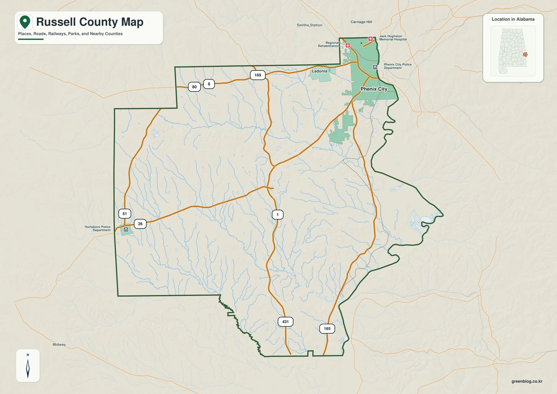
U.S. 80 is the clearest east-west route across the northern part of the county, linking the Phenix City side with the interior. U.S. 431 provides a major north-south connection through the central and southern sections, while Alabama SR 165 follows the eastern and southeastern side closer to the Chattahoochee corridor. Other numbered roads, including 169, 51, and 26 on the supplied map, add local connections toward the western and northern edges. These roads are more useful for orientation than treating each community label as an isolated point.
Phenix City and Hurtsboro show the county’s strongest settlement contrast
The ranked city map selects two places: Phenix City and Hurtsboro. Its printed index gives Phenix City a value of 38,499 and Hurtsboro a value of 421. These are the values printed on the supplied map, so they are best treated as a relative comparison within this graphic rather than as a substitute for a separately dated population table.
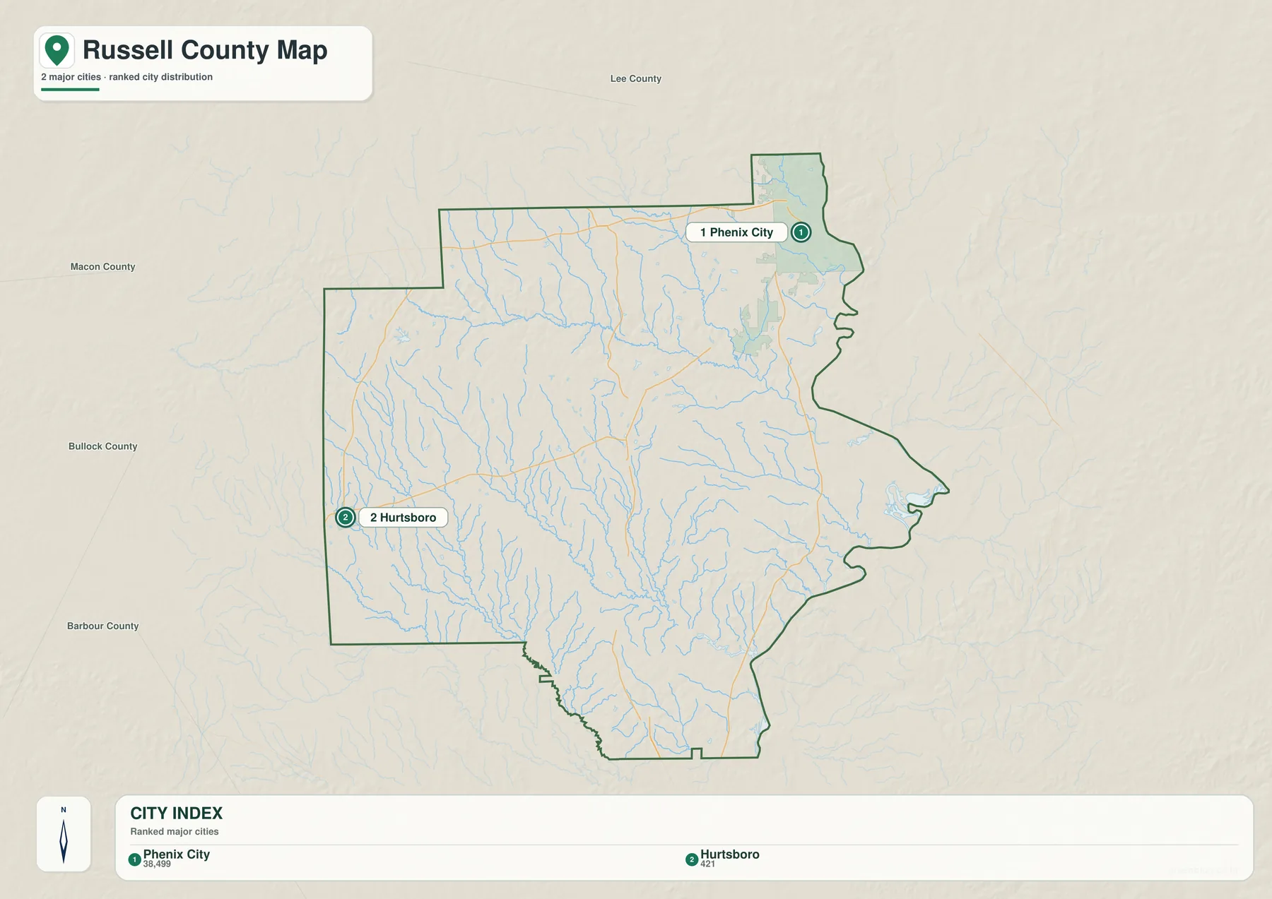
The visual difference is as important as the index values. Phenix City belongs to the Columbus-Phenix City urban area along the Chattahoochee, while Hurtsboro is far to the west in a much more rural setting. Looking at both points makes the eastward concentration of population and services easy to recognize. It also explains why a map that shows only the county outline can give an incomplete impression of where everyday activity is concentrated.
Seale adds important historical context even though it is not one of the two ranked locations. The supplied article says the county seat moved from Girard to Crawford and then to Seale in 1868. Seale and Phenix City shared county-seat functions beginning in 1926, and Phenix City became the sole seat in 1934. Comparing their positions shows a real shift in county government from the interior toward the Georgia-border urban area.
Uchee Creek and smaller streams fill the interior
The water map reveals far more detail than the general county map. Uchee Creek is one of the most prominent named streams, crossing the northern and central part of Russell County toward the east. Little Uchee Creek joins the network from the northeast. Farther south, Hatchechubbee Creek and Molasses Creek stand out, while Hurtsboro Creek and North Fork Cowikee Creek appear toward the southwestern side.
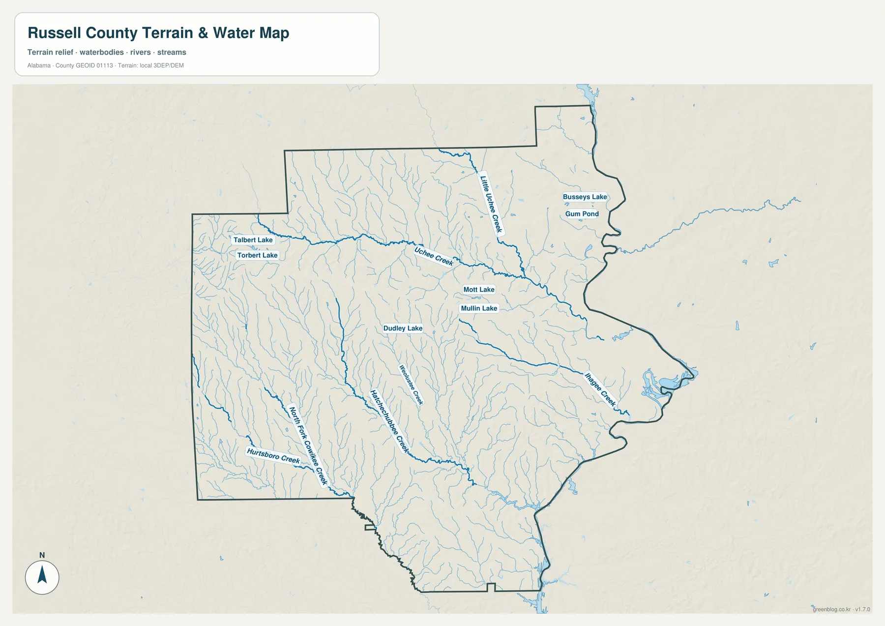
Several small water bodies are also named on the map, including Talbert Lake, Torbert Lake, Dudley Lake, Mott Lake, Mullin Lake, Busseys Lake, and Gum Pond. These local references are difficult to pick out on the road map but become easy to locate when the water layer is isolated. The branching tributaries around Uchee Creek are especially noticeable and show how densely the interior is cut by small valleys and drainage lines.
The Chattahoochee River remains the county’s dominant large water feature even though the interior map emphasizes tributaries. The supplied article identifies it as the eastern Alabama-Georgia boundary and notes that Phenix City sits directly across from Columbus. Smaller streams inside Russell County belong to the broader landscape that drains toward this river corridor, so the local creeks and the state-line river are best understood together.
This is a geographic water reference, not a flood, parcel, navigation, or engineering map. It is useful for locating named streams, comparing the county’s creek network, teaching local geography, and designing reference material. Flood-risk decisions, legal boundaries, boating, and site drainage require current official products made for those purposes.
Elevation falls toward the Chattahoochee corridor
The elevation map prints an actual range of 54 to 187 meters and a mean of 104 meters. The lowest green terrain forms a broad band along much of the eastern Chattahoochee side. Moving inland, the surface becomes more varied, with brighter slopes and brown ridges appearing across the west, northwest, and parts of the southern interior. The county is not mountainous, but it is clearly more broken than a flat plain.
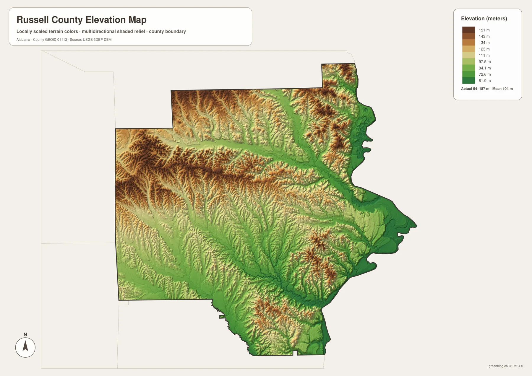
The elevation pattern adds useful context to both roads and waterways. Small streams occupy low valleys between ridges, and the eastern edge descends toward the Chattahoochee. The major highways cross this rolling terrain rather than following a perfectly regular grid. Comparing the water and elevation maps makes the relationship between the creek valleys and higher ground much easier to see.
The supplied background places Russell County in Alabama’s Coastal Plain and describes a landscape of low rolling clay hills, rivers, and streams with sandy bottoms. That description matches the broad pattern on the elevation image. The map is appropriate for county-scale terrain comparison, classroom use, and reference mapping, but it should not be treated as survey-grade elevation for a parcel, construction project, engineering calculation, or drainage design.
Roads and county-seat history explain how the interior connects to Phenix City
A practical way to orient yourself is to begin at Phenix City and follow three major directions. U.S. 80 leads west into the northern interior, U.S. 431 runs south through the county, and SR 165 serves the eastern and southeastern side closer to the river. This simple framework separates the dense northeastern urban edge from the central and western countryside and from the lower Chattahoochee-side communities.
The historical movement of the county seat reinforces that pattern. Seale represents an earlier inland administrative center, while modern county government is based in Phenix City. Fort Mitchell lies farther south along the eastern side and illustrates another kind of Chattahoochee setting: less urban than the Phenix City-Columbus edge and more dispersed across the river corridor and surrounding countryside.
Russell County contains many other communities, including Cottonton, Hatchechubbee, Pittsview, and Uchee, that are not all labeled on the supplied maps. The four-map set is therefore a county-scale reference rather than an exhaustive address or settlement inventory. For minor roads, parcels, property boundaries, or address-level navigation, the ALDOT county sheet and official local mapping resources are more appropriate.
Choose the map that matches the question
Use the general county map when you need the boundary, major roads, Phenix City, and nearby geographic context in one image. It is the quickest way to understand the shape of Russell County and how U.S. 80, U.S. 431, and SR 165 relate to the state-line city. Use the ranked city map when the main question is the contrast between Phenix City and Hurtsboro and where those selected places sit within the county.
The water map is the better choice for Uchee Creek, Little Uchee Creek, Hatchechubbee Creek, smaller lakes, and the branching stream network. The elevation map is best when the labels are less important than the physical surface. It clearly separates the lower eastern river corridor from the more rolling interior and shows why Russell County cannot be described as uniformly flat.
For printing, teaching, local-history work, or a personal map project, the maps are most useful as complementary references. The general map explains roads and position, the city map simplifies the settlement contrast, the water map isolates streams and lakes, and the elevation map shows the land beneath those features. Keeping those functions separate avoids the clutter that would come from forcing every layer into one image.
Frequently Asked Questions
Where is the Russell County seat?
Phenix City is the current county seat. It lies on the west bank of the Chattahoochee River opposite Columbus, Georgia. Seale previously served as an important county-seat location, so comparing the two places helps explain the shift from an inland administrative center to the state-line urban area.
What forms the Georgia side of Russell County?
The supplied county material identifies the Chattahoochee River as the major physical boundary along the eastern side. It separates Alabama from Georgia and places Phenix City directly across the river from Columbus.
What is included in the downloadable ZIP?
The archive contains four A3 high-resolution JPG files: a county-and-roads map, a ranked city map, a water map, and an elevation map. The body images are convenient for quick viewing, while the JPG files are better when you need larger originals for printing or map projects.
Map File Information
Russell County map files
- Included Versions: county, city, water, elevation
Related Maps
- Abbeville, Headland, and Lake Eufaula on the Henry County Alabama Map
- Athens to Wheeler Reservoir on the Limestone County Alabama Map
- Autauga County Map
Sources and references
- U.S. Census Bureau — official county and geographic data framework
- Russell County Commission — current county government and local information
- Alabama Department of Transportation — Russell County highways and mapped communities
- U.S. Geological Survey Water Data — Uchee Creek and Chattahoochee drainage references
- Encyclopedia of Alabama — Russell County history and Coastal Plain background
Green Map creates custom-edited map images using open geographic data sources such as geoBoundaries, Natural Earth, OpenStreetMap, and government open data. These maps are edited visual materials, not raw data files, and are provided for education, documents, presentations, and graphic reference.