The Shelby County Alabama Map makes more sense when the county is read as several connected landscapes rather than one suburban block south of Birmingham. Pelham, Alabaster, and Calera line up with the I-65 corridor; Chelsea and Harpersville face the U.S. 280 side; Columbiana is the county seat in the interior; and the northern and central ridges rise well above the lower river country to the east. The map files are also available for download as one ZIP containing four original A3 high-resolution JPGs, so the page can be used both as a quick reference and as a source for larger printable files.
The four maps separate information that would be crowded if it were forced into one image. The general county map is the best starting point for roads, towns, boundaries, and nearby context. A ranked city map simplifies the settlement pattern to six major places. The water map exposes the dense network of creeks and small lakes, while the elevation map shows an actual range of 60 to 470 meters and a mean of 169 meters. Read together, they explain why northern suburbs, the I-65 corridor, the county-seat area, and the eastern river side do not all look or function the same way.
Table of Contents
A county stretching from Birmingham’s southern edge toward the Coosa side
Shelby County occupies a central Alabama position immediately south of the Birmingham area. The supplied maps place Jefferson and St. Clair counties along the north, Talladega and Coosa counties to the east, Chilton County to the south, and Bibb County to the west; Tuscaloosa County appears as a southwestern outside reference on the city map. That surrounding context is useful because Shelby County sits between a major metropolitan area and a much more varied interior of ridges, smaller towns, reservoirs, and rural roads.
| State | Alabama |
|---|---|
| County | Shelby County |
| County seat | Columbiana |
| 2025 population estimate | 238,552 |
| 2020 census population | 223,024 |
| Major travel corridors | I-65, U.S. 280, AL 25, AL 119, U.S. 231, AL 145 and connecting roads |
| Water setting | Cahaba-side drainage in the west and the Coosa River/Lay Lake side in the east |
| Elevation shown | Actual 60-470 m, mean 169 m |
The source package gives a 2025 population estimate of 238,552 and a 2020 census population of 223,024. Those figures help explain why the northern and I-65 portions of the county contain closely spaced communities, but the general map is not a population-density graphic. Its first job is orientation: locate the communities, see the main routes, note the county boundary, and then connect those positions with demographic or transportation data when a project needs more detail.
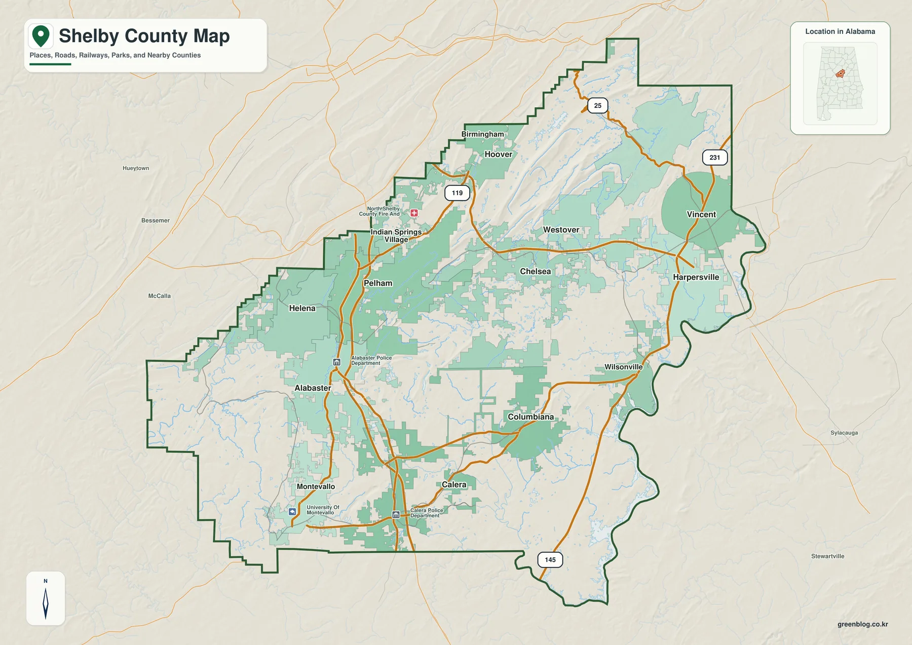
The strongest north-south pattern runs through Pelham, Alabaster, and Calera. The supplied county material identifies I-65 as the major route tying this corridor to Birmingham on the north and Montgomery farther south. A second pattern angles southeast through Chelsea, Westover, and Harpersville along the U.S. 280 side. State routes such as AL 119, AL 25, and AL 145, along with U.S. 231 and local connections, fill in the interior and eastern parts of the county.
Columbiana needs a different reading from Alabaster or Pelham. It is the county seat even though it is not the largest place on the city-ranking map. The northern boundary also includes familiar Birmingham-area names such as Birmingham and Hoover. The supplied article notes that some municipalities in this part of Alabama cross county lines, so the dark county outline matters: a city label near or across the edge should not be interpreted as meaning that the entire municipality lies inside Shelby County.
Six ranked cities show how the suburban and southern centers are distributed
The ranked city map focuses on six places and prints a value for each: Alabaster 33,917, Pelham 24,827, Helena 21,769, Calera 17,714, Chelsea 16,260, and Montevallo 7,556. These are the figures printed in the supplied city index, so they are most useful for comparing the map’s selected places rather than replacing a separately dated population table. The geographic pattern is clear even without the numbers: three of the selected places cluster in the northern and central-western part of the county, while Calera, Chelsea, and Montevallo point toward different southern, eastern, and southwestern directions.
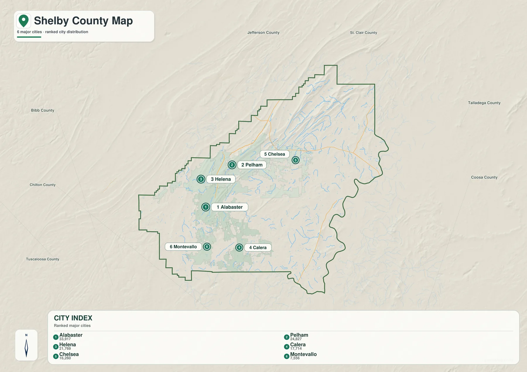
Alabaster and Pelham form the most obvious pair because they are close to each other along the I-65 side. Helena sits west of that corridor, while Chelsea is farther east along a different highway relationship. Calera extends the I-65 pattern southward. Montevallo occupies the southwest and can also be located on the general map by the University of Montevallo label. This means the six-city graphic is not simply a size ranking; it also separates several different travel and settlement settings.
Important county places remain outside the six-place ranking. Columbiana is essential because it is the county seat, and the general map also labels Wilsonville, Harpersville, Vincent, Westover, Indian Springs Village, and other communities. That is why the city map works best as a simplified comparison rather than a complete municipal inventory. Use it for relative size and position, then return to the general map when administrative location, highways, or a broader list of place names matters.
The contrast between Alabaster and Columbiana is especially useful. Alabaster carries the highest printed value on the ranked map and belongs to the strong I-65 suburban corridor, while Columbiana’s importance comes from county government. Pelham adds another role because it sits near Oak Mountain and the Birmingham-facing northern zone. Chelsea represents the U.S. 280 side, Calera the southern interstate corridor, and Montevallo the southwestern part of the county. One county therefore contains several centers that are important for different reasons.
Creeks and small lakes fill the interior between the Cahaba and Coosa sides
Water gives Shelby County a second geography that is easy to miss on a road map. The supplied background describes western and northwestern drainage associated with the Cahaba River system, while the eastern edge relates to the Coosa River and Lay Lake. The dedicated water map fills in the space between those larger systems with named creeks, branches, ponds, and lakes. It is particularly useful when the task is to understand local water features rather than merely find the largest river.
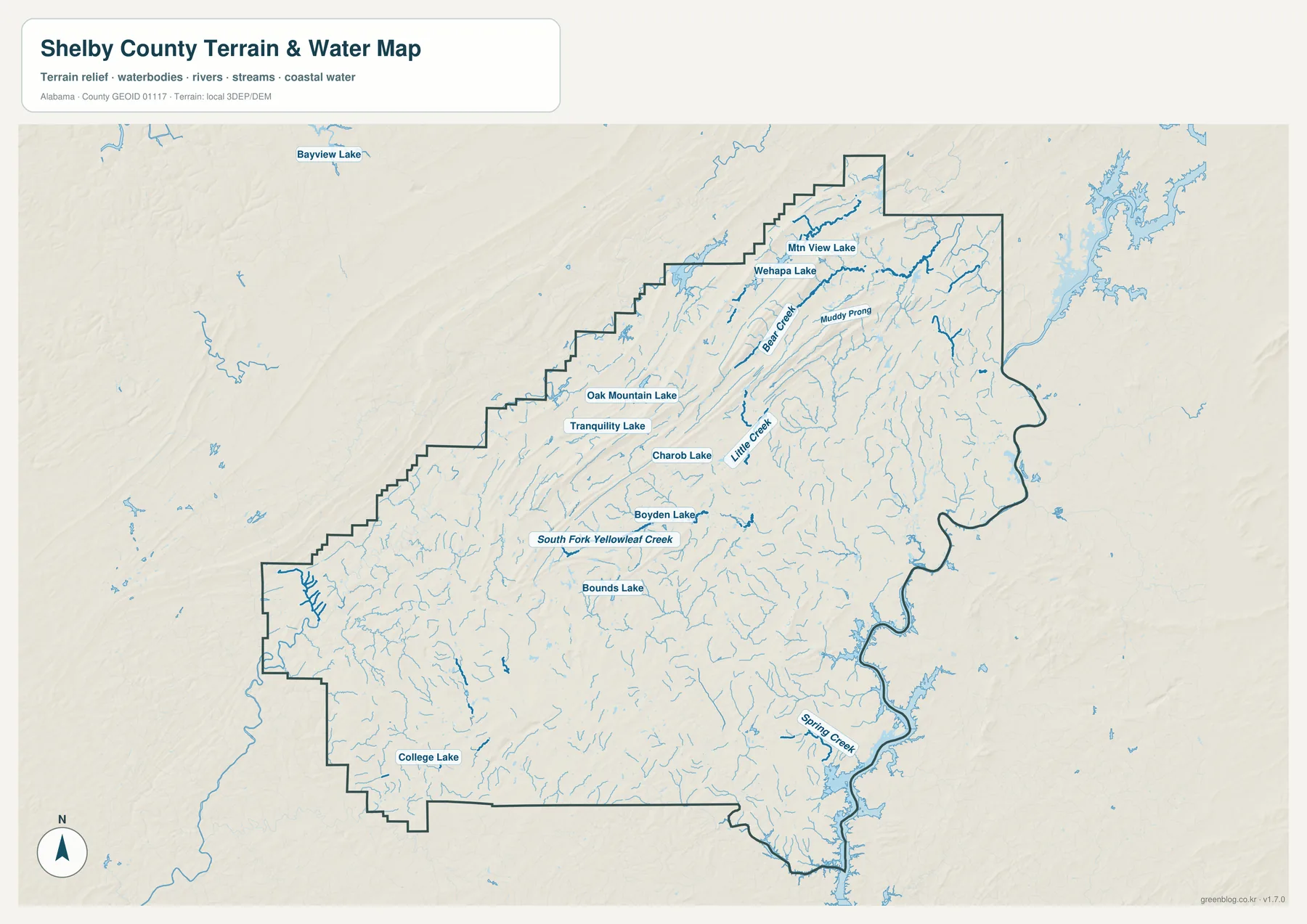
In the north-central part of the map, Oak Mountain Lake and Tranquility Lake sit within the ridge country, with Wehapa Lake and Mtn View Lake farther north. Bear Creek and Muddy Prong are labeled among the smaller channels there. Little Creek runs through the central area, while South Fork Yellowleaf Creek is a useful western and southwestern reference. Boyden Lake, Bounds Lake, and College Lake add smaller named waters that are difficult to notice on the general county map.
The eastern and southeastern edge has a different appearance because it opens toward larger river and reservoir water. The existing Shelby County material associates Harpersville and Vincent with the Coosa River side and places Lay Lake near the Wilsonville side farther south. The irregular eastern boundary on the water map helps show why this edge does not behave like a simple straight county line. On the west, the Cahaba-side drainage and Yellowleaf-related streams provide a different direction for water movement.
This distinction is useful for more than natural-history description. On the general map, Shelby County can look primarily like a north-south transportation county because of the I-65 communities. The water map adds a strong east-west contrast between different river systems and the smaller streams feeding them. It should still be treated as a geographic reference rather than a flood map, legal water-boundary record, parcel drainage study, or navigation chart.
Oak Mountain and long north-central ridges rise above the eastern lowlands
The elevation map is the clearest way to see how much relief exists inside a county often associated with Birmingham’s suburbs. Its legend reports an actual range from 60 to 470 meters and a mean elevation of 169 meters. The highest brown ridges run through the north-central part of the county in long, narrow bands. Lower green terrain becomes more widespread toward the eastern and southeastern river side, while smaller ridges and valleys continue through the central, southern, and southwestern sections.
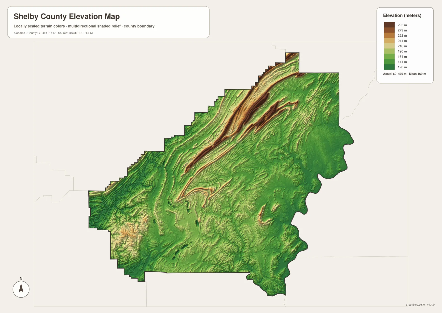
Oak Mountain State Park provides a familiar reference for this terrain. The source package describes the park in Pelham as occupying Double Oak Mountain country and covering 11,861 acres, making it Alabama’s largest state park. That fact matters for map reading because the Birmingham-facing northern area is not a flat suburban plain. Ridges, wooded slopes, and valleys occur close to Pelham and nearby developed areas, influencing the shape of roads and the practical relationship between communities that may look close in straight-line distance.
The high ground does not stop at one mountain. Parallel ridges extend southward from the north-central area, and rolling terrain continues around the interior. Chelsea and Westover lie in country that is generally lower than the highest ridge bands but still far from flat. Toward the eastern river edge, lower elevations become more common. Calera and Montevallo also sit within rolling southern and southwestern terrain rather than an entirely level landscape.
For general comparison, this relief map is useful because it answers a simple question quickly: which parts of Shelby County are higher and which are lower? It is appropriate for classroom use, local orientation, travel context, or personal map design. It is not survey-grade elevation for a particular parcel, construction site, engineering design, or drainage calculation, where more precise source data would be required.
I-65 and U.S. 280 create different directions of growth and travel
I-65 and U.S. 280 should not be treated as interchangeable references. I-65 organizes the Pelham-Alabaster-Calera side into a strong north-south line linking Birmingham with points farther south. U.S. 280 leaves the Birmingham area on a southeast course through the Chelsea-Westover-Harpersville side. Because the two routes diverge, communities that all belong to northern or central Shelby County can still have very different everyday travel directions.
Helena lies west of the interstate corridor, so its relationship with Pelham and Alabaster differs from Chelsea’s relationship with the U.S. 280 side. Montevallo is farther southwest. Columbiana sits in the interior between the largest highway corridors and serves the administrative role. Wilsonville and Harpersville are closer to the eastern water landscape. Returning to the water and elevation maps after locating these places on the road map makes those differences much easier to explain.
No single city represents every part of Shelby County because growth, government, terrain, and travel are divided among several places. Alabaster leads the six-place ranking and forms part of the I-65 corridor with Pelham, while Columbiana remains the county seat farther inland. Pelham also sits beside Oak Mountain and the Birmingham-facing north, whereas Chelsea turns toward U.S. 280 and Calera continues the interstate corridor south. Harpersville, closer to the Coosa side, adds an eastern reference that makes the county’s different travel directions easier to understand.
Choose a Shelby County map based on the question you need to answer
The general map is the best all-purpose choice when boundaries, roads, communities, and nearby counties need to be visible together. It works well for tracing the Birmingham-to-Pelham-to-Alabaster direction, locating Columbiana, or comparing the western I-65 side with Chelsea and Harpersville in the east. The ranked city map is faster when the main task is comparing Alabaster, Pelham, Helena, Calera, Chelsea, and Montevallo without the clutter of every smaller place label.
Choose the water map when local creeks and lakes matter. Oak Mountain Lake, Tranquility Lake, Wehapa Lake, Little Creek, South Fork Yellowleaf Creek, and Springs Creek are much easier to find there. Choose the elevation map when terrain is the main question. Its strongest message is the contrast between the high north-central ridge country and the lower eastern and southeastern side, with rolling ground continuing through much of the rest of the county.
For teaching, printing, local comparison, or a personal map project, the maps work well as a set because each one removes a different kind of clutter. Start with the county map for position, switch to the city map for the settlement hierarchy, use the water map for named streams and lakes, and finish with elevation when the land itself matters. This sequence is especially useful in Shelby County because metropolitan growth, highways, ridges, and waterways overlap without following one simple pattern.
Frequently Asked Questions
Is Alabaster the county seat of Shelby County?
No. Alabaster has the largest printed value on the supplied ranked-city map, but Columbiana is the county seat. The distinction is useful because population size and administrative importance do not point to the same place in Shelby County.
Why are I-65 and U.S. 280 both important on a Shelby County map?
I-65 organizes the Pelham-Alabaster-Calera corridor in a north-south direction, while U.S. 280 leads southeast through the Chelsea-Westover-Harpersville side. Looking at both routes explains why northern and eastern communities can belong to the same county yet face different travel directions.
Where is the highest terrain shown in Shelby County?
The elevation map places the strongest high ridges in the north-central part of the county, including the Oak Mountain area. The map reports an actual elevation range of 60 to 470 meters and a mean of 169 meters, with lower terrain becoming more common toward the eastern and southeastern river side.
Map File Information
Shelby County map files
- Included Versions: county, city, water, elevation
Related Maps
- Abbeville, Headland, and Lake Eufaula on the Henry County Alabama Map
- Athens to Wheeler Reservoir on the Limestone County Alabama Map
- Autauga County Map
Sources and references
- U.S. Census Bureau — 2020 Census and 2025 population-estimate background for Shelby County
- Shelby County, Alabama — Cities/Towns — county-seat and community location reference
- Alabama Department of Transportation — Shelby County Highway Functional Classification — road and local transportation context
- Alabama State Parks — Oak Mountain State Park — Oak Mountain terrain and park background
- USGS National Hydrography — water-feature reference
- USGS 3D Elevation Program — elevation reference
Green Map creates custom-edited map images using open geographic data sources such as geoBoundaries, Natural Earth, OpenStreetMap, and government open data. These maps are edited visual materials, not raw data files, and are provided for education, documents, presentations, and graphic reference.