Costa Rica sits on the Central American isthmus between Nicaragua and Panama, with the Pacific Ocean on one side of the country and the Caribbean Sea on the other. On a full Central America map, that narrow position can make the country look deceptively simple. An enlarged Costa Rica Map shows much more: the uneven Pacific coastline, the smoother Caribbean edge, the tight central interior, and seven provinces whose shapes and sizes differ sharply from one another.
This page includes three downloadable map images built from the same A3 landscape layout. The set contains a color administrative map, a labeled black-and-white version, and a blank provincial outline. Because the geography stays in the same position across all three files, the maps can move easily from a reference page to a worksheet, presentation, blog graphic, or annotation project. The collection is designed for province-level geographic reference rather than street navigation.
The labeled maps identify Guanacaste, Alajuela, Heredia, Cartago, Limón, San José, and Puntarenas. Nicaragua and Panama remain visible outside the national boundary, while the Pacific Ocean and Caribbean Sea give the coastline a clear geographic setting. That surrounding context matters in Costa Rica because several provinces extend toward a coast or international border, and the arrangement is easier to understand when the country is viewed together with its neighbors.
Table of Contents
Reading Costa Rica Between Two Coasts
Costa Rica stretches generally from northwest to southeast. Nicaragua forms the northern border, while Panama meets the country at the southeastern end. The Pacific side is visually more complex, with an extended shoreline and several projecting coastal forms, whereas the Caribbean side appears smoother in this map collection. Limón occupies much of the eastern side, so the Caribbean coast and that province become closely linked in the overall shape of the country.
The seven provinces vary greatly in size and shape rather than dividing Costa Rica into equal-looking pieces. Guanacaste occupies a broad northwestern area, and Alajuela reaches across much of the north-central interior. Limón follows the eastern side, while Puntarenas is especially easy to recognize because it extends along a large part of the Pacific coast and continues toward Panama. Its long form contrasts strongly with the smaller central provinces and helps explain why a province map is more informative than a simple national outline.
San José, Heredia, and Cartago occupy relatively compact areas near the center of the country. Their close arrangement makes this part of the map more crowded than the broad provincial shapes in Guanacaste or Limón. The A3 landscape composition gives the national outline enough room for those central boundaries and names to remain readable. It also keeps the surrounding countries and coastlines visible without reducing Costa Rica to a small shape in the middle of the page.
What the Three Costa Rica Map Files Show
All three files focus on Costa Rica’s first-level provincial divisions. Cantonal boundaries, highways, relief shading, national parks, travel routes, and detailed city locations are outside the scope of the artwork. As a result, the collection is most useful for understanding where the seven provinces sit, which provinces meet a coast or border, and how their shapes relate to the country as a whole. More detailed transport or topographic questions require a different map source.
The labeled artwork uses English geographic labels. In the image itself, “San jose” and “Limon” appear without the Spanish accent marks used in the standard forms San José and Limón. The blank outline removes province names, neighboring-country labels, and ocean labels while keeping the same provincial boundaries and surrounding land shapes. This consistency makes it possible to compare the three versions without having to learn a different layout each time.
Color-Coded Provincial Map
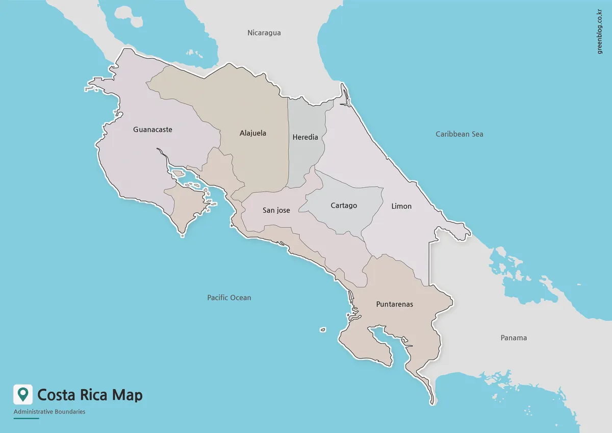
Color makes the provincial pattern easiest to separate at a glance. Adjacent areas use muted fills that keep the internal boundaries visible without competing with the coastline or labels. The difference is most noticeable around Heredia, San José, and Cartago, where several provincial edges sit close together. Puntarenas also stands out more clearly in color because its long Pacific-side extent can be followed across the lower and southeastern portions of the country.
The color Costa Rica Map fits situations in which province separation needs to be immediate, such as a projected lesson, a country introduction, an online article, or a comparison slide. Nicaragua and Panama remain visually quieter than Costa Rica, while the surrounding water is separated from the land. The national boundary therefore stays prominent even when the image is viewed from a distance, and the province colors add orientation without turning the page into a detailed thematic map.
Labeled Black-and-White Reference
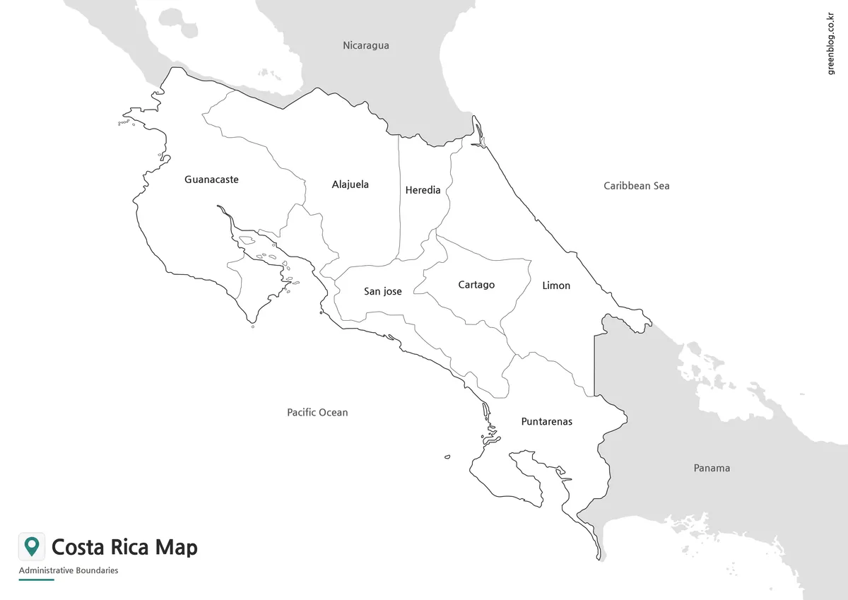
The black-and-white file keeps the seven province names and the surrounding geographic labels but removes the colored interiors. That simpler treatment works well in study sheets, reports, handouts, and documents where the map shares space with a large amount of text. White provincial areas also leave room for handwritten numbers, notes, arrows, or symbols, which can be useful when the image is printed or placed into a classroom activity.
Boundary lines carry most of the visual information in the monochrome version. Guanacaste can be located in the northwest near Nicaragua, Limón follows the Caribbean side, and Puntarenas can be traced along much of the Pacific edge. The labeled black-and-white map also pairs naturally with the blank outline because both use the same geography. One can function as a reference while the other is used for labeling, coloring, or a simple province-identification exercise.
Blank Provincial Outline
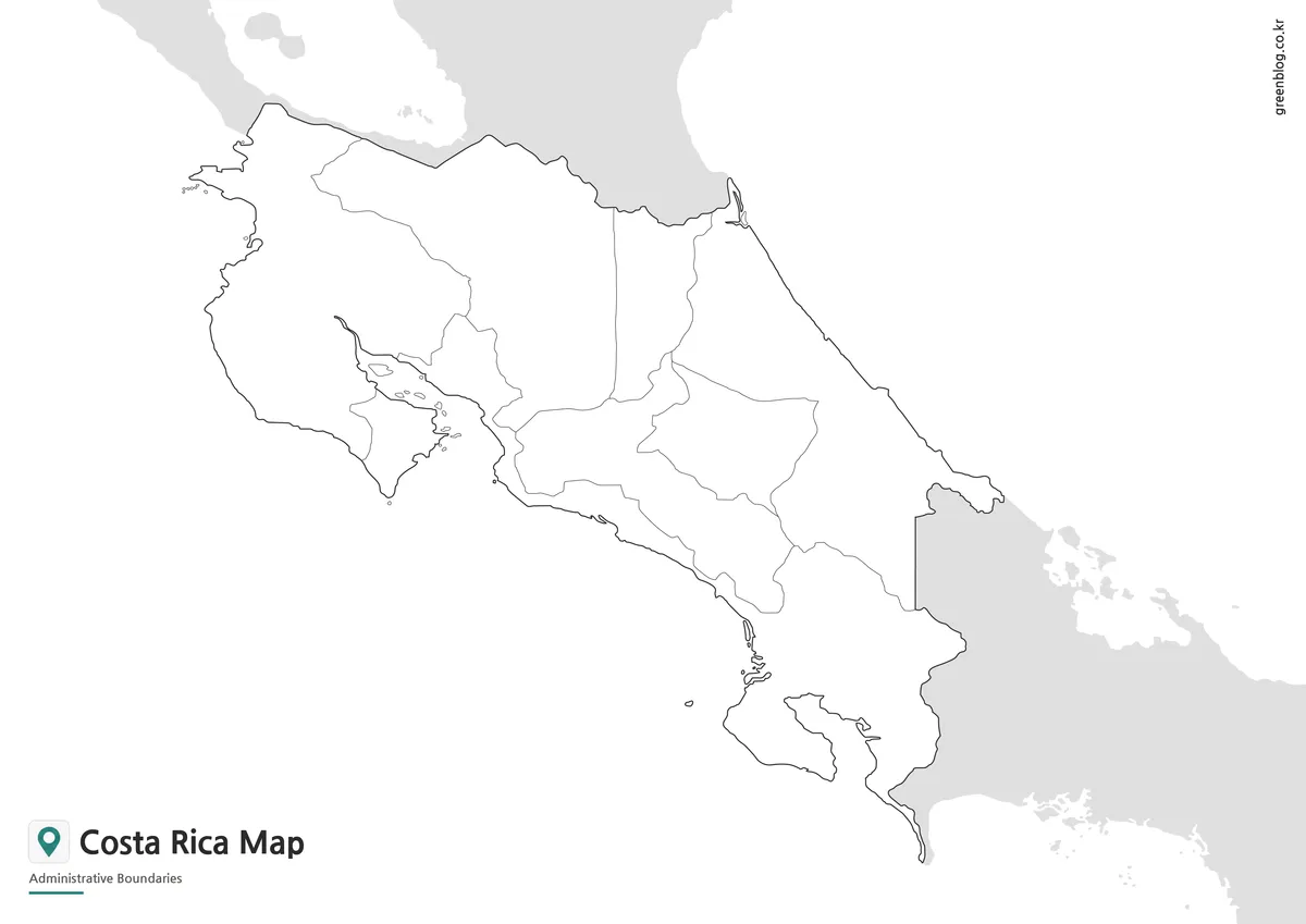
The blank outline removes the text from the provincial areas and surrounding geography while keeping Costa Rica’s external boundary, all seven internal divisions, nearby coastlines, and simplified neighboring land. The result is an uncluttered base that leaves more room for custom labels and marks. Because the provincial framework is already present, the image can support a worksheet or presentation without requiring the user to redraw the country before adding information.
A blank Costa Rica Map is especially useful when the purpose is to add information rather than read existing labels. It can support province labeling, coloring, custom symbols, arrows, or a sourced data overlay. The file is supplied as an image, and no editable vector source is confirmed in this package. That distinction matters for design work: the map can be annotated in raster or presentation software, but the provincial areas are not confirmed as separate vector objects.
Choosing a Version for the Task
Each version serves a slightly different visual need. The color map makes the seven provinces easiest to distinguish from one another, especially in the compact central area. The labeled monochrome version keeps geographic names prominent while remaining suitable for black-and-white printing. The outline leaves the most open space for a reader’s own labels or fills. Since all three share the same orientation and provincial framework, moving between them does not change the geographic reference point.
For classroom work, the outline and labeled map form a practical pair. Students can complete the empty provincial layout and compare it with the labeled reference without having to match two different map designs. In presentations, the same relationship works in reverse: an outline can introduce the country shape, and the labeled or color version can add more detail later. The shared A3 landscape composition keeps those transitions visually consistent.
These files are not intended for distance measurement, street finding, or current driving directions. Their strength is the stable province-level framework rather than a detailed transport network. A travel presentation can still use the maps to show broad location or provincial context, but route planning and local navigation depend on current transportation information. Keeping those uses separate prevents a clean administrative map from being mistaken for a road or tourism map.
Classroom, Presentation, and Design Uses
In a classroom, the visible province shapes create several straightforward geography activities. The seven names can be matched to their positions, international-border provinces can be compared with coastal provinces, and the compact central areas can be contrasted with the long form of Puntarenas. Because those tasks rely on features already present in the maps, the page remains focused on what the downloadable files actually show rather than mixing in unrelated country facts.
The identical composition also helps with presentation and graphic design. A sequence can move from the blank outline to the labeled black-and-white map and then to the color version while the country stays in the same place on the slide. Bloggers can use the labeled image as a clean geographic reference, while designers can duplicate the outline and add sourced statistics or annotations. The map remains a base layer, and any added data stays visually distinct from the original provincial framework.
The landscape A3 format gives the Pacific coastline and neighboring context enough horizontal space to remain recognizable. When the image is reduced for a smaller page or narrow web column, the central labels and fine coastal details become the first elements to lose clarity. Nicaragua and Panama also provide useful orientation around the country, so keeping that surrounding context visible preserves the map’s Central American setting even when the image is displayed at a smaller size.
Map Scope and Labeling Notes
Provincial boundaries are the most detailed administrative lines included in this collection. Costa Rica is subdivided further into cantons and districts, but those smaller divisions are outside this collection. The colored areas also represent administrative provinces rather than tourism regions. That distinction keeps the purpose of the page clear: the maps explain the seven-province structure and national setting, while more specialized local or travel boundaries belong to other map types.
The three Costa Rica Map files work best as printable province references and as clean bases for additional annotation. Population figures, tourism categories, conservation information, or transportation data can be added in a separate layer when a project requires them, with the source and date kept alongside that added material. This approach preserves the original provincial map as a stable reference and makes it clear which information came from a later dataset or project-specific overlay.
Frequently Asked Questions
How many provinces appear on the maps?
The collection shows Costa Rica’s seven provinces: Guanacaste, Alajuela, Heredia, Cartago, Limón, San José, and Puntarenas. Cantonal and district boundaries are not included, so the maps remain focused on province-level geography and broad national orientation.
Which Costa Rica Map is best for a classroom worksheet?
The blank provincial outline provides the most open space for student labels, coloring, or annotations. The labeled black-and-white version works well beside it as a reference or answer sheet because the same seven provincial divisions appear in the same positions.
Why does Puntarenas look so long on the map?
Puntarenas Province extends along a large part of Costa Rica’s Pacific side and continues toward the border with Panama. Its long coastal form is part of the provincial layout shown in the artwork, which is why it looks very different from the smaller central provinces.
Do the files show roads or tourist destinations?
No. The maps concentrate on the national outline, seven provincial boundaries, neighboring countries, and broad coastal context. Highways, street networks, national parks, hotels, and attraction markers are not part of this collection, so detailed travel information requires a separate current source.
Can the blank map be edited?
The blank image can be annotated in presentation or raster-editing software with labels, arrows, symbols, and color overlays. No editable vector source is confirmed in the package, so the file is best treated as a high-resolution image base rather than a set of separate vector province shapes.
Map File Information
This ZIP contains three Costa Rica province maps in the same A3 landscape layout for geographic reference, classroom work, presentations, annotation, and raster-based design.
- Included Versions: Color administrative, labeled black-and-white, and blank provincial outline maps
- Printable Size: A3 landscape layout
- File Type: Image files grouped in a ZIP archive
- Intended Use: Printing, education, presentations, annotation, blog graphics, and infographic design
Related Maps
- Printable Colombia Map Set – Regional, Blank, and Black & White Versions
- Argentina Map Pack – Color, Blank and Printable A3 Maps
- Printable Paraguay Map Collection for Education and Design Projects
- Printable Bolivia Map Set – High-Resolution Maps for Education and Design
Additional Resources
- Costa Rica Maps – Visit Costa Rica: The country’s official tourism website provides destination and regional maps for readers who need travel-oriented information beyond the provincial maps in this collection.
Green Map creates custom-edited map images using open geographic data sources such as geoBoundaries, Natural Earth, OpenStreetMap, and government open data.
These maps are edited visual materials, not raw data files, and are provided for education, documents, presentations, and graphic reference.