Artigas Department Map is a practical visual resource for understanding Uruguay’s northernmost department, its international borders, and the unusual way its municipalities are distributed. Artigas Department touches Brazil to the north and east, Argentina across the Uruguay River to the west, and Salto Department to the south. The departmental capital, Artigas, sits near the Brazilian border in the northeast, while Bella Unión lies far to the northwest near the point where Uruguay, Brazil, and Argentina come close together.
Because these two urban centers are separated by a wide rural area, a written list of place names does not fully explain how the department is organized. A labeled regional map makes the distances, border directions, and settlement pattern much easier to understand. Artigas covers about 11,928 square kilometers and has a population of roughly 77,000, but only three areas are organized as municipalities: Bella Unión, Tomás Gomensoro, and Baltasar Brum.
The Artigas Department Map collection includes a color map, a black and white map, and an outline map. Each version serves a different purpose, from classroom handouts and presentation slides to regional comparisons, blog graphics, worksheets, and custom infographic projects. The collection is provided as image files designed for printing, screen use, and graphic annotation.
Table of Contents
Understanding the Artigas Department Map
The administrative layout is the most important feature of this regional resource. Bella Unión, Tomás Gomensoro, and Baltasar Brum are concentrated in the western part of the department rather than spread evenly across its entire area. The capital city of Artigas is not shown as a fourth municipality. Instead, it appears as a city marker within the much larger part of the department that lies outside the three municipal boundaries.
That distinction explains why large sections of the map may appear empty at first glance. Those spaces are not missing administrative data. They represent non-municipalized territory that includes rural land, smaller settlements, and the area surrounding the departmental capital.
The western edge and the spaces between the three municipalities belong to this same category when they fall inside the department boundary. They should not be interpreted as separate unnamed municipalities.
Municipalities and Main City
The Artigas Department Map identifies the three municipality areas separately from Artigas, which is marked as the departmental capital rather than as another municipality.
The three municipalities shown on the map are:
- Bella Unión
- Tomás Gomensoro
- Baltasar Brum
The principal city label is:
- Artigas
Bella Unión occupies the northwestern edge of the department near the Uruguay River and the border zone shared with Brazil and Argentina. Tomás Gomensoro and Baltasar Brum extend southeast from this western area and form part of the department’s western settlement corridor.
Artigas city, by contrast, lies in the northeast opposite the Brazilian city of Quaraí. This creates a strong visual contrast between the compact municipal areas in the west and the broad non-municipalized territory covering much of the remaining department.
The Artigas Department Map is particularly helpful for distinguishing place names from administrative areas. Bella Unión, Tomás Gomensoro, and Baltasar Brum appear as areas with defined boundaries, while Artigas appears as a point marking the location of the departmental capital.
Color-Coded Municipal Layout
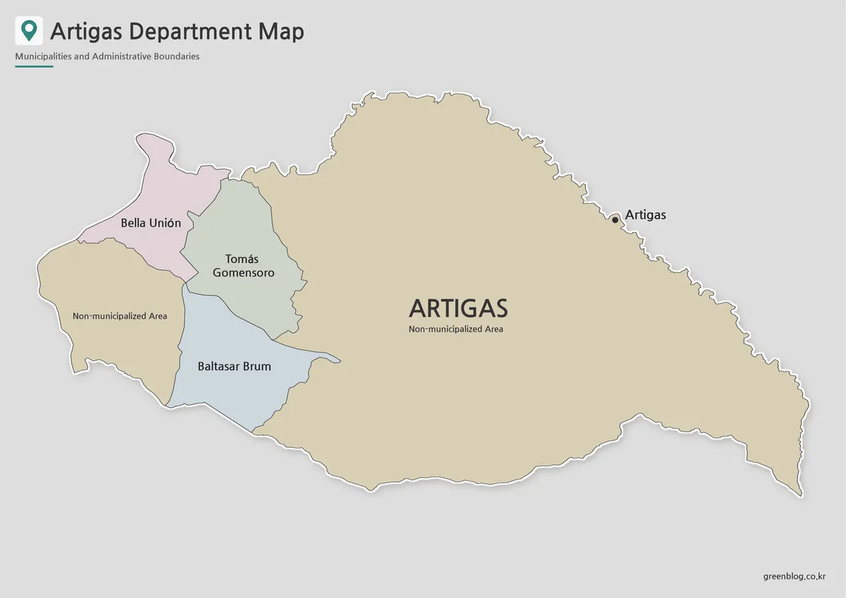
The color version of the Artigas Department Map makes the three western municipalities easier to compare. Because they sit close to one another, separate colors help readers follow each boundary without confusing it with the much larger surrounding territory.
The non-municipalized area is kept visually different from the three municipalities, while the city of Artigas is identified with a separate point marker. This format works especially well for lessons about local administration, border geography, and the difference between a city location and a municipality covering a defined area.
Color is also useful when comparing the relative size of the three municipal areas. Readers can quickly see that the municipalities occupy only a limited portion of Artigas Department rather than dividing the department from edge to edge.
This version works well in presentation slides, educational posters, blog graphics, and regional comparison material where the administrative structure needs to be understood at a glance.
Black and White Printable Version
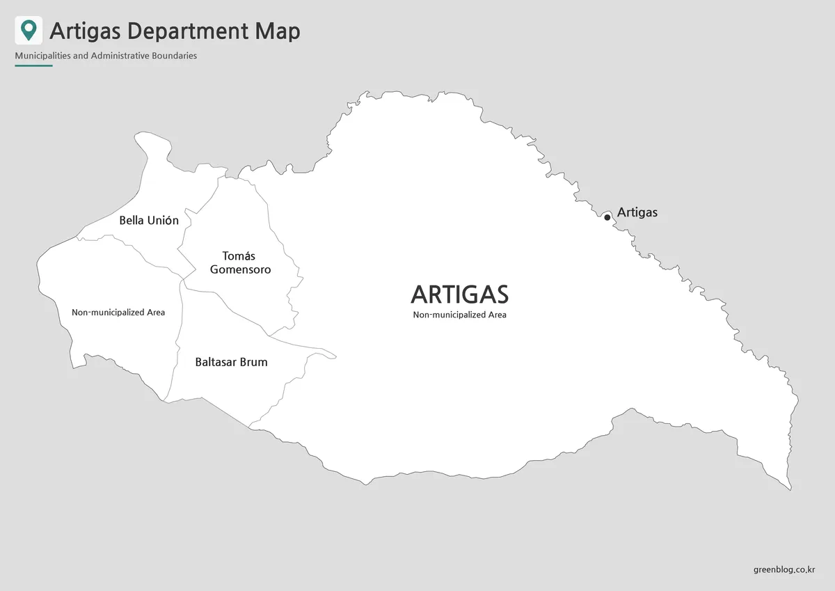
For printed reports, school assignments, and document inserts, the black and white version keeps attention on place names and boundary lines. The cleaner layout is helpful when users need to write notes, add symbols, or photocopy the page without depending on color.
The relationship between the western municipalities and the northeastern capital remains visible in this simplified layout. It is also easier to compare the department’s outside border with its internal municipal boundaries, making the map suitable for worksheets and printed regional reference sheets.
The black and white Artigas Department Map is useful when labels matter more than color. Bella Unión, Tomás Gomensoro, Baltasar Brum, and Artigas remain easy to identify, while the lighter visual style leaves room for handwritten explanations.
Teachers can use this version for geography assignments, and presentation creators can place it beside tables or written summaries without the map competing with surrounding design elements.
Outline Map for Custom Projects
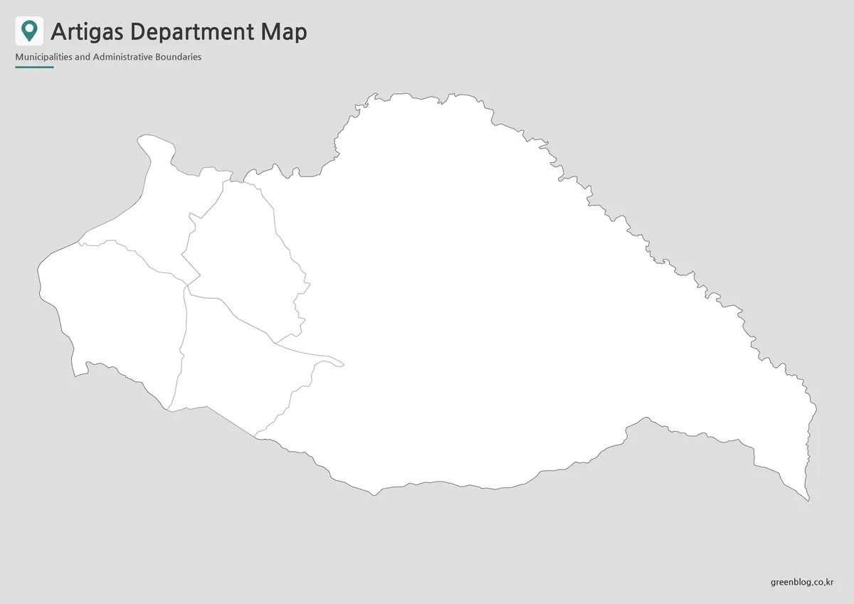
The outline version of the Artigas Department Map works as a base for custom information. Users can add population figures, agricultural production, border crossings, travel routes, city markers, or presentation highlights without competing with a colored background.
Teachers may use it for labeling exercises or coloring activities, while designers can build infographics around the contrast between municipal and non-municipal territory. It also works well for showing the route between Bella Unión and Artigas or for marking the Uruguay River and Cuareim River as border features.
Because the western municipalities occupy only part of the department, the blank areas provide useful space for adding rural population data, transportation links, land-use information, or custom regional groupings. The outline is therefore more than a simplified map; it serves as a working base for new visual information.
The boundary-only format is also suitable for video backgrounds, presentation animations, and classroom projects where users want to introduce locations one at a time.
Practical Uses for the Map Collection
The three versions support different types of projects:
- Classroom handouts explaining Uruguay’s departmental structure
- Geography worksheets about municipalities and international borders
- Presentation slides comparing western and northeastern settlements
- Infographics showing population, agriculture, or land use
- Blog graphics about Uruguay’s northern border region
- Travel or transportation diagrams connecting major towns
- Printable reference sheets for regional studies
- Editable visual projects requiring clean boundary lines
A simple written description cannot clearly show how far Artigas city is from Bella Unión or why the municipalities appear only in one part of the department. The Artigas Department Map provides that spatial context while keeping the administrative structure easy to read. The Artigas Department Map also gives infographic creators a clear base for comparing the western municipalities with the capital city and the wider non-municipalized area.
Choosing the Right Map Version
Choose the color Artigas Department Map when the main goal is to compare Bella Unión, Tomás Gomensoro, and Baltasar Brum with the surrounding non-municipalized territory. The visual separation makes it the strongest option for presentations, lessons, and regional comparisons.
Use the black and white map for printed handouts, reports, assignments, and reference documents where names and line clarity are more important than color.
The outline map is the better option when users need to add statistics, routes, symbols, city markers, or custom regional information. Its open layout provides more freedom for editing and annotation.
Selecting the right Artigas Department Map depends on whether the project requires immediate regional comparison, clean document printing, or space for custom annotations.
Frequently Asked Questions
Why are there only three municipalities on the map?
The Artigas Department Map shows three municipalities: Bella Unión, Tomás Gomensoro, and Baltasar Brum. The remaining territory lies outside those municipal boundaries and is classified as non-municipalized territory.
What does “Non-municipalized Area” mean?
It refers to land within Artigas Department that is not part of one of the three municipalities. This includes the area surrounding the departmental capital and large rural sections.
Is Artigas one of the municipalities?
Artigas is shown as the departmental capital and a major city. It is not one of the three municipal areas displayed as colored or bounded regions.
Why does part of the map look empty?
The apparently empty areas are not missing sections. They represent non-municipalized territory inside the outer boundary of Artigas Department.
Which version works best for classroom use?
The color map is useful for explaining administrative areas, the black and white version works well for printed handouts, and the outline map is suitable for labeling and coloring activities.
Download Information
Choose the version that best matches your project. The collection includes three visual styles for printing, classroom reference, presentation design, and custom graphic work.
Map File Information
This download includes printable Artigas Department map versions for educational use, presentation design, document printing, and editable graphic projects.
- Included Versions: Color map, black and white map, outline map
- Printable Size: Printable image layout
- File Type: Image files
- Intended Use: Classroom handouts, presentations, blog graphics, infographic editing, and printable reference materials
Related Maps
Additional Resources
- Uruguay Ministry of Environment Map Viewer — An official interactive map service for checking departmental boundaries, municipalities, populated areas, and other geographic layers across Uruguay.
Green Map creates custom-edited map images using open geographic data sources such as geoBoundaries, Natural Earth, OpenStreetMap, and government open data.
These maps are edited visual materials, not raw data files, and are provided for education, documents, presentations, and graphic reference.