A Buenos Aires Map becomes much more informative when it moves beyond a single capital-city marker and shows the 48 officially recognized barrios of the Autonomous City of Buenos Aires. The city faces the Río de la Plata to the east and meets Buenos Aires Province along its other sides, creating a fan-shaped urban outline with waterfront neighborhoods, compact central areas, and larger barrios toward the west and south.
This collection includes three image-based versions built around those barrio boundaries: a color labeled map, a black-and-white labeled map, and a blank outline map. The labeled editions help readers locate places such as Palermo, Recoleta, Puerto Madero, La Boca, Flores, and Villa Lugano, while the outline edition provides room for custom labels, routes, statistics, or project markers.
The distinction between city and province is essential. Buenos Aires City, formally the Ciudad Autónoma de Buenos Aires or CABA, is not part of Buenos Aires Province even though the two share a name and border one another. These files depict the autonomous city’s neighborhoods, not the much larger province and not its partidos. They also show barrio boundaries rather than the city’s separate 15-comuna administrative framework.
Table of Contents
What the Buenos Aires Map Actually Shows
Buenos Aires is officially divided into 48 barrios, all of which appear on the two labeled maps. Among them are the large northern barrios of Palermo and Belgrano, the central and eastern areas of Recoleta, Retiro, San Nicolás, Monserrat, San Telmo, and Puerto Madero, and southern barrios such as Barracas, La Boca, Nueva Pompeya, Villa Soldati, Villa Lugano, and Villa Riachuelo. The Río de la Plata is labeled along the eastern side.
The Buenos Aires Map should not be described as a map of 48 administrative districts. Under the city’s political and administrative system, the formal decentralized units are 15 comunas, each of which contains one or more barrios. Palermo alone forms Comuna 14, for example, while Comuna 1 groups Retiro, San Nicolás, Puerto Madero, San Telmo, Monserrat, and Constitución. The supplied images do not draw the outer boundaries of those 15 groupings as a separate layer.
Barrios remain highly useful geographic references. They help readers understand where familiar cultural, residential, commercial, and waterfront areas sit within the city. However, the maps contain no streets, transit lines, stations, landmarks, or addresses, so they are best treated as neighborhood-orientation resources rather than navigation maps.
Reading the City from the River to the Western Edge
The Río de la Plata creates the clearest edge on the map. Puerto Madero occupies a long waterfront position east of the traditional center, while Retiro lies to its north and La Boca and Barracas extend southward. Recoleta and Palermo form large, recognizable areas farther north, making them useful anchors when readers begin locating the smaller barrios around the center.
Central Buenos Aires contains several compact shapes and tightly arranged names. San Nicolás, Monserrat, San Telmo, Constitución, Balvanera, San Cristóbal, Almagro, and Boedo sit within a relatively small portion of the page. Here, label size and line weight matter because an oversized name can obscure a boundary or make two neighboring barrios appear connected.
The western half of the city contains a different pattern. Villa Devoto, Villa del Parque, Villa Pueyrredón, Villa Urquiza, Liniers, Mataderos, and Parque Avellaneda occupy broader spaces than many central barrios. Farther south, Villa Lugano and Villa Soldati are especially prominent. Following those changes across the Buenos Aires Map helps viewers understand why one label layout cannot be applied uniformly to all 48 areas.
Color Map for Separating Adjacent Barrios
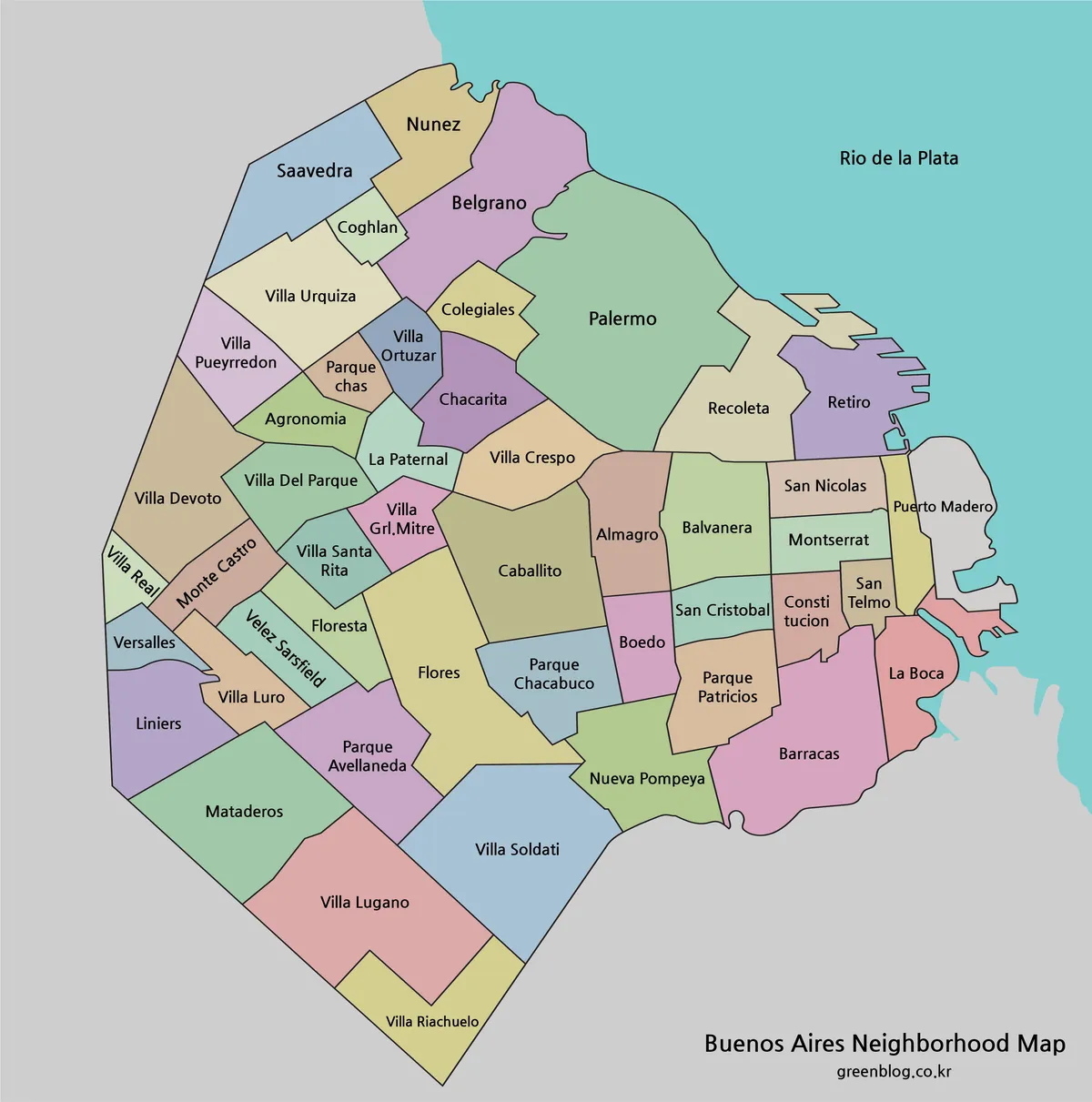
The color Buenos Aires Map gives each barrio a distinct muted fill. Color separation is most helpful through the center, where Balvanera, Almagro, Boedo, San Cristóbal, Constitución, San Telmo, Monserrat, and San Nicolás meet within a dense grid of boundaries. It also makes the narrow waterfront form of Puerto Madero easier to distinguish from the surrounding river and neighboring city areas.
Larger barrios such as Palermo, Villa Devoto, Flores, Villa Lugano, and Villa Soldati remain easy to identify without heavy colors. This version suits city introductions, neighborhood comparison slides, blog graphics, and guides that refer to several barrios in one discussion. The palette provides orientation but does not encode population, land use, or any other statistic.
Black-and-White Labeled Reference
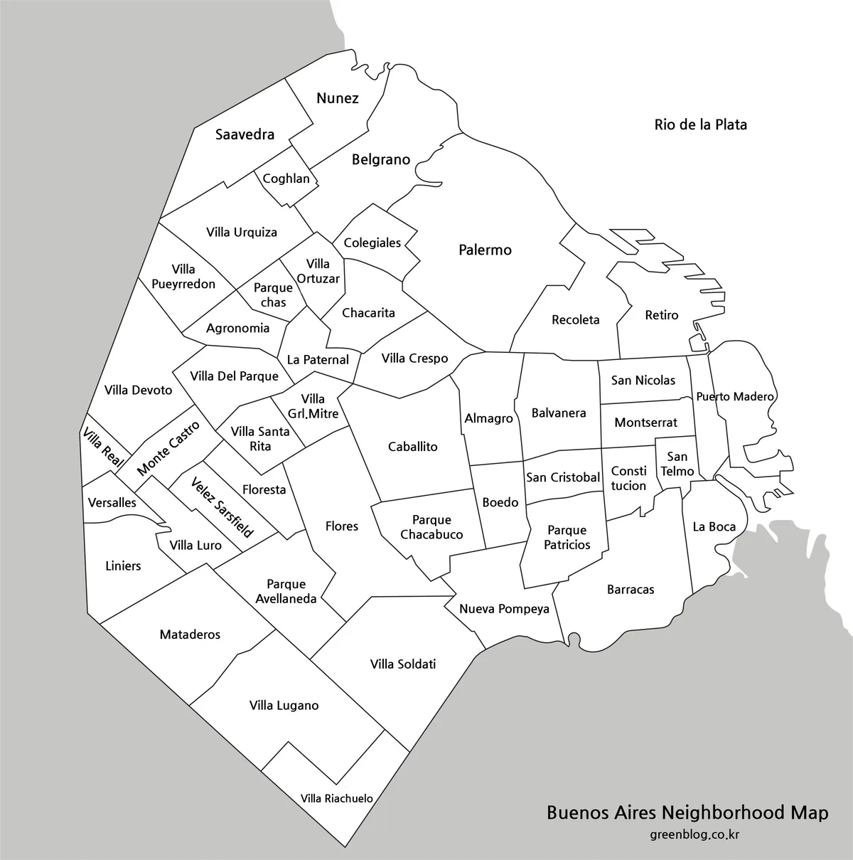
The monochrome Buenos Aires Map preserves the 48 barrio names and boundary lines while removing the colored fills. White interiors contrast with the gray surrounding area and keep attention on place names. This simpler appearance can sit beside photographs, tables, or written explanations without adding an unrelated color scheme to the page.
Small labels need special care when the image is reduced. Longer names such as Villa General Mitre, Villa Pueyrredón, Constitución, Parque Chas, San Telmo, and Puerto Madero occupy relatively narrow areas or may need to be divided across lines. Before printing, inspect the central and northwestern labels rather than judging clarity only from Palermo or other large barrios.
Blank Barrio Outline for Annotation
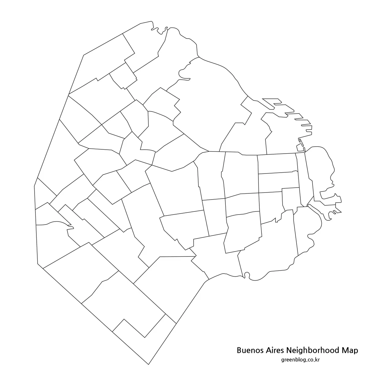
The outline Buenos Aires Map removes barrio names, surrounding shading, and the Río de la Plata label. It retains the city silhouette, waterfront detail, and all internal barrio boundaries. The result is an uncluttered raster image for adding information rather than a finished street or navigation map.
Students can label selected barrios or use the labeled edition as an answer key for all 48. Travel writers can place numbered attractions in Recoleta, San Telmo, La Boca, Palermo, and Puerto Madero without forcing long landmark names into small spaces. Data projects can shade barrios by a verified statistic, provided the source year and legend are added separately.
Choosing and Preparing the Map
Select the color version when an audience needs to separate neighboring barrios quickly on a screen. Choose black and white for a labeled handout, report, or study sheet where the map must coexist with other content. Use the outline map when readers are expected to supply labels, colors, symbols, routes, or values themselves.
Preserve the nearly square proportions when placing the Buenos Aires Map in a document. Stretching it into a wide landscape frame would distort the relationship between the long waterfront and the western and southern barrios. When reducing the image, inspect the compact central labels and narrow boundaries before printing or exporting the final page.
Use the standard Spanish forms of barrio names in accompanying text, including Núñez, Agronomía, Constitución, San Nicolás, Vélez Sarsfield, Villa Ortúzar, and Villa Pueyrredón. Consistent spelling is particularly important when labels from the map are repeated in a table, itinerary, caption, or worksheet answer key.
Classroom, Travel, and Infographic Uses
A classroom activity can begin by distinguishing Buenos Aires City from Buenos Aires Province. Students can then identify the Río de la Plata, locate the northern and southern waterfront, and label a selected set of barrios before attempting all 48. A second exercise can group the barrios into the city’s 15 comunas using an official reference, making clear that comuna groupings are not drawn on these files.
For a neighborhood guide, the Buenos Aires Map provides broad location context but should not replace a street or transit map. Numbered points can link attractions to a separate list, while route lines should be checked against current transport or walking information. This approach keeps dense central labels readable and avoids implying that straight lines on the graphic represent actual streets.
An infographic can compare barrio-level statistics, project locations, or categories when reliable data are available. Use one visual variable at a time, include a legend, and identify the reference year. The size of a barrio on the page does not indicate its population, density, income, visitor volume, or cultural importance.
Frequently Asked Questions
Does this Buenos Aires Map show the city or the province?
It shows the Autonomous City of Buenos Aires and its 48 barrios. It does not show Buenos Aires Province, which is a separate and much larger jurisdiction surrounding the city on three sides. The city’s eastern edge faces the Río de la Plata.
Are the 48 barrios the same as the 15 comunas?
No. Barrios are the named neighborhoods outlined on these maps. The 15 comunas are decentralized political and administrative units that group one or more barrios. The supplied files show barrio boundaries but do not add a separate layer outlining each comuna.
Which map is best for learning neighborhood names?
Use the black-and-white labeled version as the main reference because it shows all 48 names without color becoming the primary cue. The blank outline can then serve as a recall worksheet. Begin with large barrios such as Palermo and Flores before moving to the compact central areas.
Can I use the outline map for a travel itinerary?
Yes, but add current route and attraction information from a suitable city source. Numbered markers are preferable when several stops fall in Recoleta, San Telmo, Monserrat, or Puerto Madero. The outline supplies neighborhood context but contains no streets, transit services, travel times, or navigation directions.
Should Spanish accent marks be retained in barrio names?
Yes. Written material should retain standard forms such as Núñez, Constitución, San Nicolás, Vélez Sarsfield, Villa Ortúzar, and Villa Pueyrredón. Using the same spelling in headings, captions, tables, and worksheet answers makes it easier to compare the article with Spanish-language city references.
Download Information
Map File Information
This download contains three image-based maps of the 48 barrios of the Autonomous City of Buenos Aires for reference, printing, presentations, and annotation.
- Included Versions: Color labeled map, black-and-white labeled map, and blank barrio-outline map
- File Type: Image files grouped in a ZIP archive
- Intended Use: Classroom handouts, city guides, presentations, blog graphics, neighborhood labeling, and infographic projects
Related Maps
- South America Map Download|Printable Country Maps
- Printable Guyana Map for Classrooms, Presentations, and Editing
- Download Uruguay Map Files for Printing, Editing, and Infographics
- Ecuador Map Download for Printing, Classroom Use, and Graphic Editing
Additional Resources
- Buenos Aires Ciudad — Barrios: Explore official information about the location, boundaries, history, and characteristics of the city’s 48 barrios.
Green Map creates custom-edited map images using open geographic data sources such as geoBoundaries, Natural Earth, OpenStreetMap, and government open data.
These maps are edited visual materials, not raw data files, and are provided for education, documents, presentations, and graphic reference.