Box Butte County occupies a broad section of Nebraska’s northern Panhandle, with Alliance in the southeast and Hemingford much farther north. The county looks open and rural on the map, but its roads, rail lines, creeks, and gradual elevation change provide a clear internal structure. Higher ground dominates the west and northwest, while Alliance sits closer to the lower eastern side.
This page follows those features from the county road map to the city distribution, water features, and elevation map. The original high-resolution JPG files are also available in a ZIP download, which is useful when road labels, creek names, or terrain details need to be viewed at a larger size.
Table of Contents
Start at Alliance, then work north toward Hemingford
Alliance is the county seat and the easiest place to begin reading the map. Its developed area is the largest in Box Butte County, and several highways and rail lines converge there. Hemingford is north of Alliance, with Berea lying between the two along the broader transportation corridor.
Dawes County borders Box Butte County to the north, Sheridan County is to the east, Garden County lies south, and Sioux and Morrill Counties are west. Scotts Bluff County appears beyond the southwest corner. The outline is broadly rectangular, but several steps along the southern boundary make the full county line worth checking when following rural roads near the edge.
Alliance gathers the county’s largest highway and rail connections
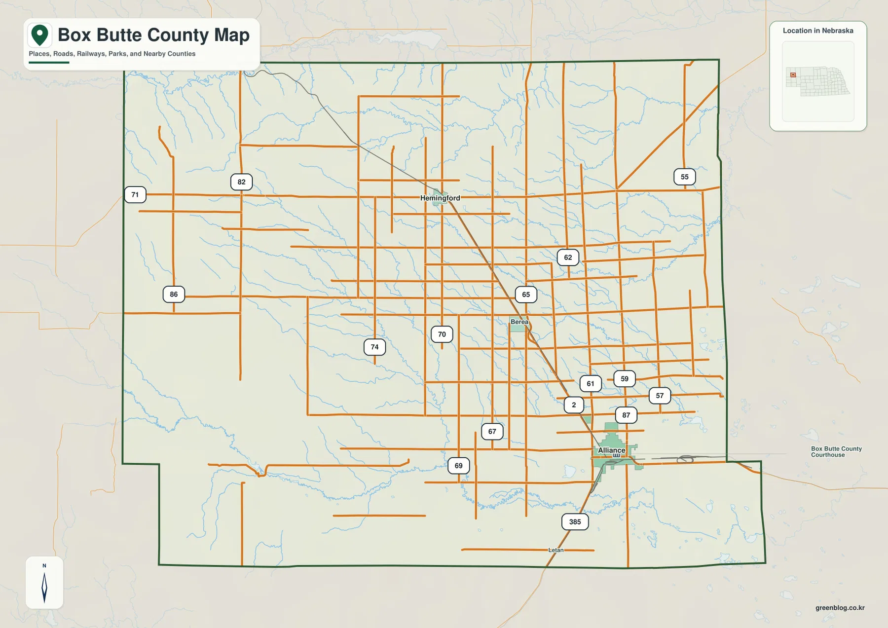
The road map is most detailed around Alliance. Nebraska Highway 2 crosses the city, Highway 87 reaches the same area, and U.S. 385 provides a strong north-south reference. Rail lines also meet near Alliance, giving the southeastern corner a transportation pattern that is noticeably denser than the rest of the county.
North of Alliance, the corridor passes Berea and continues toward Hemingford. Highways 71 and 82 are visible around Hemingford, while routes marked 55, 62, and 65 serve the eastern countryside. Roads 70, 74, and 86 appear farther west and through the interior, linking farm and ranch areas where settlements are widely spaced.
The map is designed for geographic orientation rather than live navigation. Rural roads can cover long distances between junctions, and current construction, closures, or surface conditions may change. Nebraska 511 or another current routing source should be used when planning an actual trip.
Alliance and Hemingford define two different settlement centers
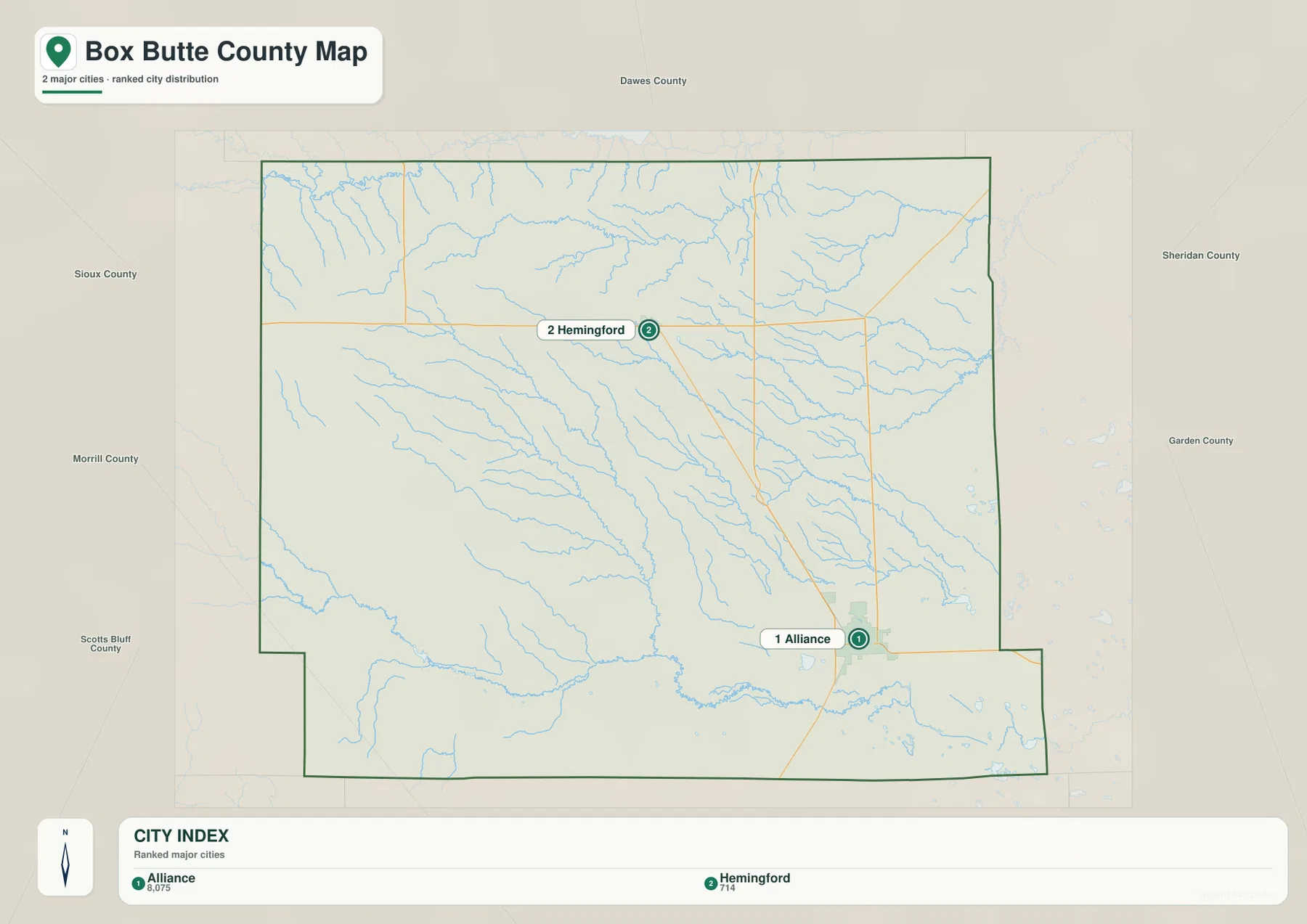
The city map ranks Alliance first and Hemingford second. Alliance has a much larger developed footprint in the southeast, while Hemingford appears as a compact town in the north-central part of the county. The official county profile also shows a large population difference between the two communities.
No straight-line connector or mileage is drawn between the two cities on the supplied map. For that reason, the useful comparison here is their position rather than an invented distance. The general road map gives the better picture of how Alliance and Hemingford are linked in practice.
Their history is also connected. Box Butte County’s official account says the county seat moved from Nonpareil to Hemingford before Alliance became the permanent seat in 1899. The old courthouse was moved by rail from Hemingford to Alliance, a detail that shows how important rail transportation was to the county’s early development.
Small creeks do most of the work between the Niobrara and Snake Creek
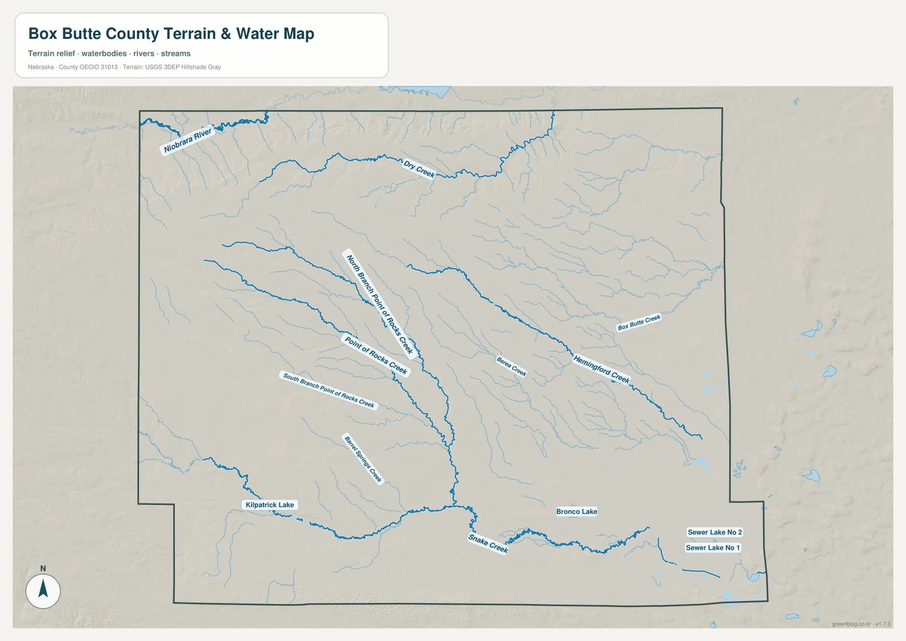
The Niobrara River appears only along the far northwestern edge of the supplied water map. South of it, Dike Creek crosses the northern interior, while a series of smaller streams drains the central and eastern parts of the county. Box Butte County therefore does not have one large river running through its middle; the landscape is divided by many smaller valleys instead.
North Branch Point of Rocks Creek and Point of Rocks Creek form a prominent pair in the center. Berea Creek and Hemingford Creek follow long southeastward courses, and Box Butte Creek is visible farther east. These streams are especially useful for understanding the county’s overall slope because many begin in higher western or central ground and run toward the lower east.
Snake Creek crosses the southern part of the county, with Kilpatrick Lake near the western side. Bailey Branch Creek lies in the south-central area, while Bronco Lake and Sewer Lake No. 1 and No. 2 appear farther east. The mix of creeks and small lakes gives the southern map more variety than a road-only view would suggest.
This water map is for geographic reference. It does not establish flood risk, legal water rights, property lines, channel depth, or public access. Those questions require current records from the responsible agencies.
The county loses roughly 255 meters of elevation toward the east
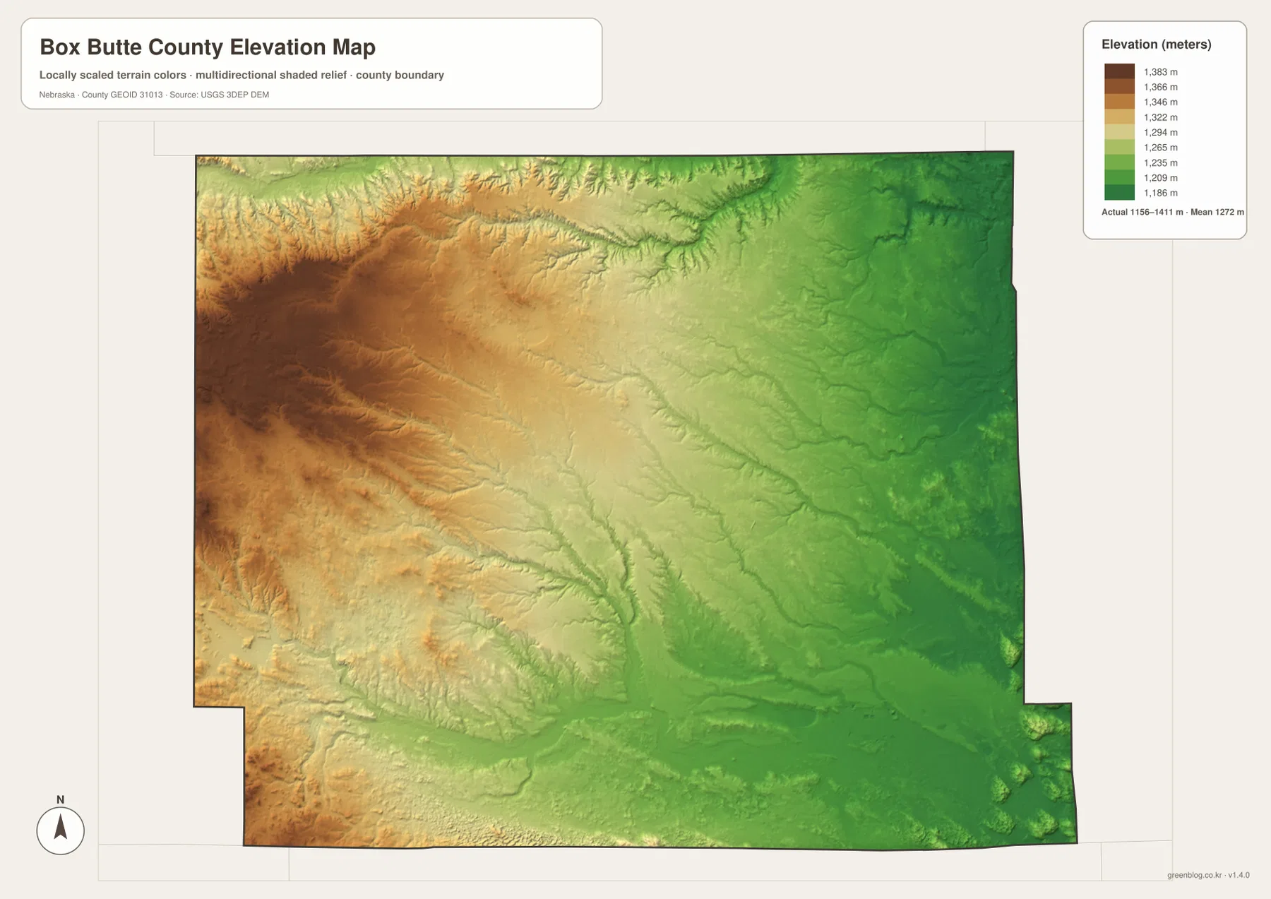
The elevation map gives a county-wide range of about 1,156 to 1,411 meters, with a mean near 1,272 meters. Brown and tan colors dominate the west and northwest, while green becomes more common toward the east and southeast. The change is gradual rather than a single steep drop, but the west-to-east slope is clear across the full map.
The higher western country is cut by many shallow valleys. Dike Creek, Point of Rocks Creek, Hemingford Creek, and related branches occupy lower bands through the uplands. When the water and elevation maps are compared, many blue stream lines follow greener terrain.
Alliance lies in the lower southeastern portion of the county. Hemingford is farther north and somewhat closer to the transition into higher western ground. Snake Creek also occupies a lower corridor across the south, helping show how the county’s drainage and elevation are connected.
The elevation surface is generalized for county-wide viewing. It is appropriate for comparing broad relief but not for surveying, engineering, construction, drainage design, or parcel work, which require original elevation data and professional measurements where needed.
Railroads helped shift the county’s center of gravity to Alliance
Box Butte County was separated from southern Dawes County after a public vote in 1886 and was formally organized in 1887. The county’s official history describes rapid change after railroad development reached the area. Alliance grew quickly and eventually replaced Hemingford as the permanent county seat in 1899.
That history still makes sense on the modern map. Major highways and rail lines converge around Alliance, and its developed area is far larger than other settlements in the county. Hemingford remains an important northern community, but administrative and transportation functions are concentrated farther southeast.
A local butte gave the county its name
The official county profile says Box Butte County was named for a large butte about 12 miles north-northeast of Alliance. The landform was thought to look box-shaped from above, giving the county a name tied directly to local terrain rather than to a person or town.
The county-wide elevation map does not define the precise boundaries of that butte, but it does provide useful context for a landscape in which higher ground is concentrated to the west and northwest. A detailed topographic source is better for locating or measuring the landform itself.
Combine the maps to understand roads, water, and relief
For basic orientation, locate Alliance first and use U.S. 385 and Nebraska Highways 2 and 87 as reference lines. Then follow the road and rail corridor north through Berea toward Hemingford, where Highways 71 and 82 provide another useful set of landmarks.
For physical geography, start at the Niobrara River and Dike Creek in the northwest, then trace Point of Rocks Creek, Hemingford Creek, Box Butte Creek, and Snake Creek. The elevation map explains why many of those streams trend toward the lower east and southeast.
The downloadable high-resolution JPG files are useful when smaller road labels or creek names need to remain readable. The county map emphasizes roads and boundaries, the city map isolates the two principal communities, the water map highlights creeks and lakes, and the elevation map shows the broad west-to-east change in relief.
Frequently Asked Questions
Does the city map show a distance between Alliance and Hemingford?
No. The supplied city map ranks and locates Alliance and Hemingford but does not include a connector line or mileage. Use the general road map for relative position and a current routing service when actual driving distance or travel time is needed.
Which side of Box Butte County is highest?
The west and northwest are generally highest. The map shows an overall range of about 1,156 to 1,411 meters, with lower ground becoming more common toward Alliance and the eastern side.
Does the Niobrara River cross the whole county?
No. On the supplied map, the Niobrara River appears only near the northwestern edge. Smaller waterways such as Dike Creek, Point of Rocks Creek, Hemingford Creek, Box Butte Creek, and Snake Creek are more widespread within the county.
Map File Information
The ZIP contains the original high-resolution JPG files for the Box Butte County boundary and road map, city distribution map, terrain and water map, and elevation map.
- Included Files: Use only the versions confirmed in the article and supplied images
- File Type: Use the confirmed download contents
- Intended Use: Printing, education, presentations, and map-based projects
Related Maps
Sources and references
- Box Butte County official profile and history
- History Nebraska – Box Butte County Historical Note
- U.S. Census Bureau TIGER/Line Shapefiles
- USGS National Hydrography
- USGS 3D Elevation Program
These maps are intended for geographic reference. For legal boundaries, land ownership, flood determinations, water rights, road conditions, construction, surveying, or other decisions requiring current authoritative information, consult Box Butte County and the responsible state or federal agency.
Green Map creates custom-edited map images using open geographic data sources such as geoBoundaries, Natural Earth, OpenStreetMap, and government open data. These maps are edited visual materials, not raw data files, and are provided for education, documents, presentations, and graphic reference.