Blaine County sits in the Sandhills of north-central Nebraska, with Brewster and Dunning providing two useful anchors in a landscape dominated by rolling grass-covered ridges and river valleys. Brewster, the county seat, lies near the North Loup River, while Dunning is farther southwest near the meeting of the Middle Loup and Dismal rivers. Those two settings make the county much easier to understand than its simple boundary shape suggests. High-resolution map files are available for download in the section below.
This page covers the county road network, the ranked locations of Brewster and Dunning, the North Loup, Middle Loup, and Dismal rivers, and the elevation changes across the Sandhills. The original high-resolution JPG versions of all supplied maps can also be downloaded together in a ZIP for printing, classroom work, or personal reference.
Table of Contents
Brewster and Dunning divide the county between two river settings
Blaine County lies in north-central Nebraska. Brown County borders the north, Thomas County is west, Custer and Logan Counties are to the south, and Loup County lies east. Cherry and Rock Counties also appear around the wider map frame. The county is part of the Nebraska Sandhills, so the ground inside the boundary is much more textured than the relatively simple county outline might imply.
The official Blaine County website identifies Brewster as the county seat and lists Dunning among the county’s main communities. On the map, Brewster is a little northeast of center while Dunning sits in the southwest. Large stretches of ranch country separate them, and each community is tied to a different river corridor.
Numbered roads meet the river valleys at Brewster and Dunning
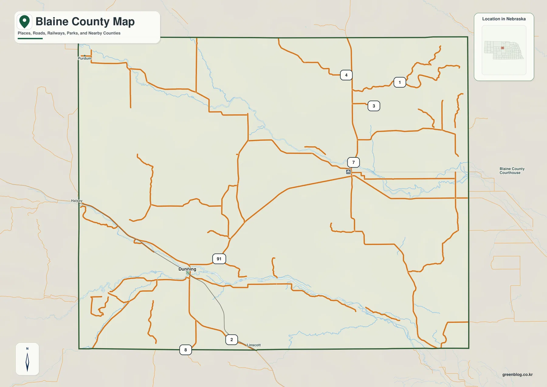
Brewster sits near the road marked 7, which runs north and south through the central-eastern part of the county. Farther north, the map shows routes marked 4, 3, and 1 spreading into the rural northeast. The road pattern is sparse compared with an urban county, and long stretches of Sandhills separate major junctions.
Dunning appears near roads marked 2 and 91 in the southwest. Halsey is visible outside the western edge and Linscott appears just beyond the southern boundary, providing useful references for travel beyond Blaine County. Purdum is labeled near the northwest corner, separated from Brewster and Dunning by broad areas with few settlements.
These roads do not form a perfect grid because the Sandhills and river valleys influence where practical routes can go. A place that looks close across the page may require a longer drive along the available roads. Use the county map for orientation, then check current routing and road-condition information for actual travel.
The city map ranks Dunning first and Brewster second
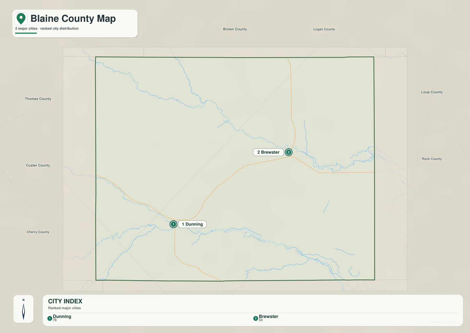
The ranked city map contains two selected places: Dunning in the southwest and Brewster farther northeast. Dunning is marked first and Brewster second. The large amount of open space between the two markers is one of the clearest visual signs of how lightly settled Blaine County is.
No connector line or straight-line mileage appears between the two places, so the map should not be used to infer a specific distance. Its strength is positional rather than numerical. It shows that the county seat, Brewster, is not the same place as the first-ranked community on this particular city index.
The county’s official profile confirms Brewster as the county seat. History Nebraska also records Brewster’s long administrative role and describes Dunning as a community that developed along the railroad. Reading the city map alongside the road and river views helps separate civic function, settlement size, and physical geography instead of treating them as the same thing.
The North Loup River crosses the north while two rivers meet near Dunning
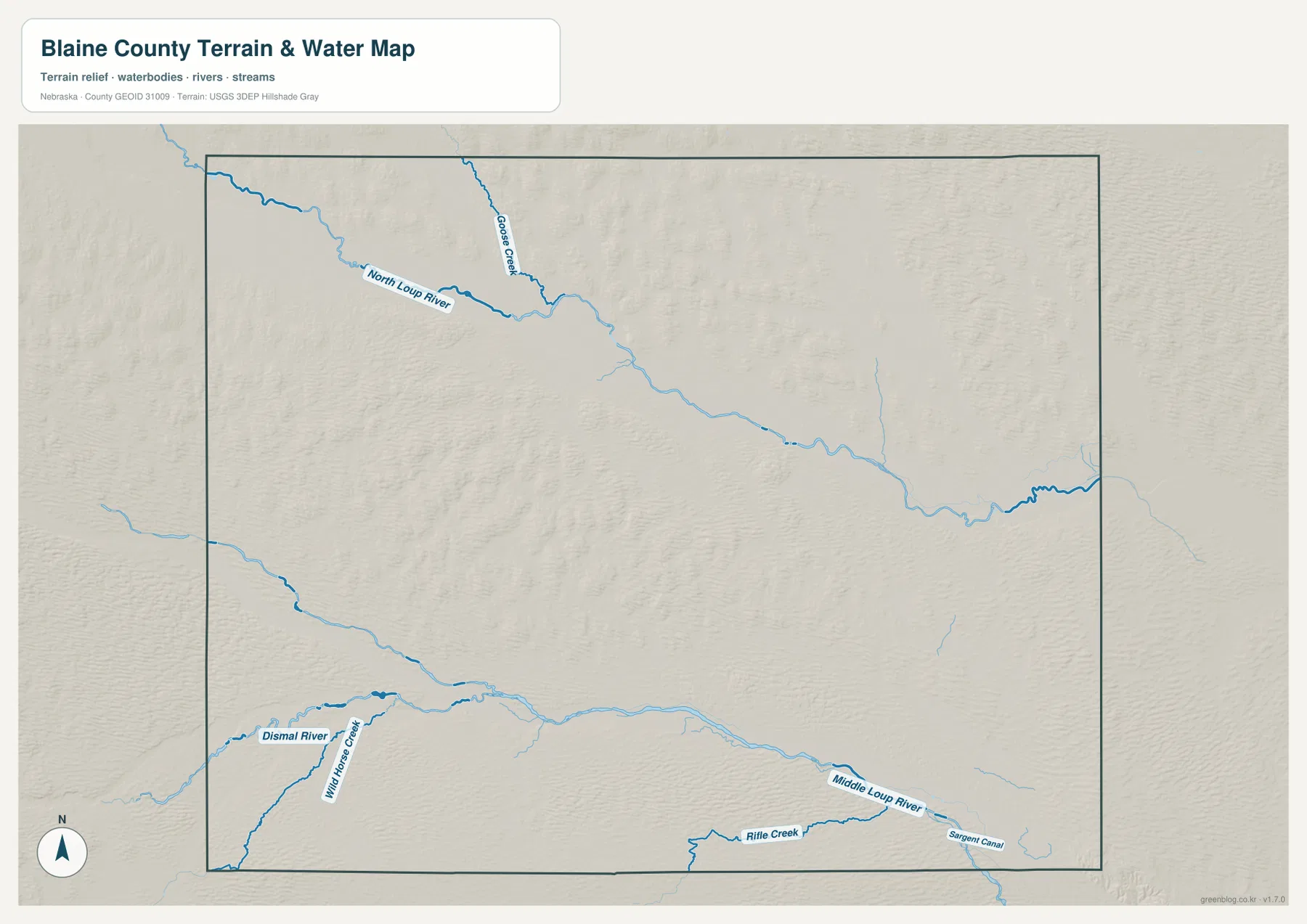
The North Loup River is the main water feature in the northern part of Blaine County. It enters from the west, crosses the county on a generally southeastward course, and continues beyond the eastern boundary. Goose Creek approaches from the north and joins the same valley. USGS maintains a monitoring-location record for the North Loup River at Brewster, confirming the close geographic relationship between the county seat and this river corridor.
The southern half has a different river system. The Middle Loup River reaches Dunning from the west, while the Dismal River approaches from the southwest. The rivers meet just east of Dunning, and USGS has separate monitoring-location records for both waterways at Dunning. This confluence makes the Dunning area the most distinctive hydrologic junction on the supplied map.
Mile Horse Creek is labeled south of the Dismal River, and Rifle Creek appears along the southern edge. Sargent Canal is marked farther southeast. Between the northern and southern river corridors, much of the county consists of smaller valleys and rolling Sandhills rather than a single large continuous drainage.
The water map is intended for geographic reference. It does not define flood zones, legal water rights, parcel boundaries, channel depth, or public access. Those questions require current records from USGS or the appropriate Nebraska and local agencies.
Elevation ranges from about 729 to 894 meters across the Sandhills
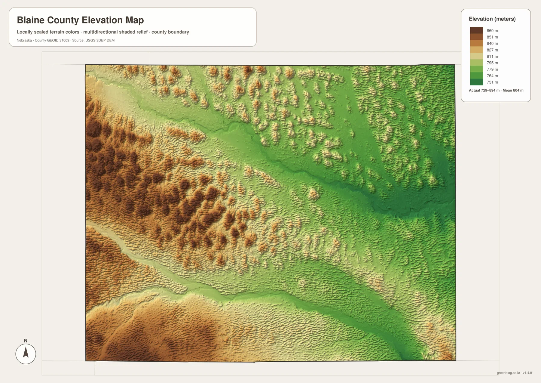
The elevation map reports an actual county-wide range of roughly 729 to 894 meters, with a mean near 804 meters. Higher tan and brown terrain is concentrated in the west and southwest, while broader green areas appear toward the east and northeast. The total difference is about 165 meters, but the relief looks stronger because small ridges and valleys repeat continuously across the Sandhills.
The North Loup River occupies a clearly lower band through the northern half of the county. A second low corridor follows the Middle Loup and Dismal rivers in the south. Between those river valleys, closely spaced ridges create a textured central upland rather than a broad flat plain.
The eastern half is generally lower, but it is still crossed by many small ridges. North and south of the North Loup valley, the terrain rises and falls repeatedly, and the same pattern continues around the Middle Loup corridor in the southeast. This is a useful reminder that the Sandhills are rolling terrain even where the overall elevation trend slopes downward.
The colors are scaled locally for Blaine County, so they are meant to compare one part of this map with another. A similar shade on a different county map may represent another absolute elevation. The surface is generalized and should not be treated as survey-grade information for construction, engineering, drainage design, or property work.
Dunning and Brewster sit in different Loup River corridors
Putting the city and water maps together makes the two main communities easier to understand. Dunning is close to the Middle Loup-Dismal confluence, while Brewster is associated with the North Loup valley. Both communities are tied to lower ground, but they belong to separate river settings divided by a broad belt of Sandhills.
USGS monitoring records reinforce that pattern. The agency lists Middle Loup River at Dunning and Dismal River at Dunning as separate stream locations, while another record covers North Loup River at Brewster. The county therefore offers a clear example of how small communities in the Sandhills often sit near dependable river corridors rather than being evenly scattered across the uplands.
Blaine County organized in 1886 and made Brewster the permanent seat
History Nebraska records that the county’s boundaries were defined by the Nebraska Legislature on March 5, 1885, and Blaine County was organized in 1886. Choosing the county seat took more than one election. Ladora won an early vote, but a later election in 1887 resulted in Brewster becoming the permanent county seat.
Brewster began developing in the 1880s, while Dunning grew as a railroad community. The Kinkaid Act later brought another period of settlement and the creation of numerous rural post offices across the county. As ranches consolidated and population declined, many of those small settlements disappeared, leaving the widely spaced communities visible on the modern map.
How to use the Blaine County maps together
For a first look, find Brewster and Dunning on the general county map, then locate the North Loup River in the north and the Middle Loup-Dismal system in the south. Those four reference points explain much of the county’s layout. Purdum and the neighboring county labels help establish the outer edges and show how far the rural road network extends from the two principal communities.
For physical geography, compare the water and elevation maps. The low river valleys appear as broad green corridors, while the western and southwestern Sandhills rise into tan and brown terrain. Around Dunning, the meeting of the Dismal and Middle Loup rivers is especially easy to understand when the water and elevation views are considered together.
The city map is the simplest choice for comparing the relative positions of Dunning and Brewster. For printing or classroom use, the downloadable high-resolution JPG files preserve more label detail than the web previews. The county, city, water, and elevation views each emphasize a different part of the same rural landscape.
Frequently Asked Questions
Does the city map give a distance between Dunning and Brewster?
No. The supplied city map ranks and locates Dunning and Brewster, but it does not include a connector line or straight-line mileage. Use a current routing service when actual road distance or travel time is needed.
Which rivers meet near Dunning?
The Middle Loup River and Dismal River meet just east of Dunning. USGS has monitoring-location records for both rivers at Dunning, making the community a useful reference point for the southern Blaine County drainage network.
Can the 729-894 meter elevation range be used for surveying?
No. The range summarizes a generalized county-wide elevation surface intended for geographic comparison. Surveying, construction, engineering, and detailed drainage work require original elevation data and, when appropriate, professional field measurements.
Map File Information
The ZIP contains the original high-resolution JPG files for the Blaine County boundary and road map, ranked city map, terrain and water map, and elevation map.
- Included Files: Use only the versions confirmed in the article and supplied images
- File Type: Use the confirmed download contents
- Intended Use: Printing, education, presentations, and map-based projects
Related Maps
Sources and references
- Blaine County official profile
- History Nebraska – Blaine County Historical Note
- USGS – North Loup River at Brewster
- USGS – Middle Loup River at Dunning
- USGS – Dismal River at Dunning
- USGS 3D Elevation Program
These maps are intended for geographic reference. For legal boundaries, land ownership, flood determinations, water rights, road conditions, construction, surveying, or other decisions requiring current authoritative information, consult Blaine County and the responsible state or federal agency.
Green Map creates custom-edited map images using open geographic data sources such as geoBoundaries, Natural Earth, OpenStreetMap, and government open data. These maps are edited visual materials, not raw data files, and are provided for education, documents, presentations, and graphic reference.