Wright County occupies a broad piece of north-central Iowa where small towns, straight farm roads, lakes, and two major river systems create a more varied landscape than the road grid first suggests. Clarion sits near the middle of the county, Eagle Grove anchors the southwest, and Belmond stands out in the northeast. Iowa 3 provides a strong east–west reference through Goldfield, Clarion, and the Rowan area, while U.S. 69 helps organize the eastern side. The four maps on this page are also available as high-resolution JPG originals in a ZIP file for closer label reading and printing. High-resolution map files are available for download in the section below.
The county becomes especially interesting when water and elevation are compared. Boone River follows the western side, while the West Branch Iowa River and Iowa River drain the east. Between them, Eagle Creek, White Fox Creek, and smaller tributaries descend through a higher central area. Lake Cornelia, Elm Lake, Morse Lake, and Big Wall Lake add several easy landmarks away from the larger rivers. On a road map the county can look orderly and flat; on the terrain maps it becomes a landscape of two drainage systems separated by higher ground.
Clarion is also the county’s administrative anchor. The official Wright County website lists the courthouse in Clarion, and Iowa Judicial Branch history records that the county seat moved there in 1866. That makes Clarion a practical reference point for reading the rest of the map. Eagle Grove lies southwest, Belmond northeast, Goldfield west along Iowa 3, Rowan east, and Dows near the southeastern side. Looking outward from Clarion quickly shows that Wright County is not dominated by one compact urban cluster.
Table of Contents
Using Clarion and Iowa 3 to Orient the County
Clarion and Iowa 3 are the easiest starting points for a first look at Wright County. Clarion sits close to the geographic center, and Iowa 3 runs west–east through the middle portion of the county. Follow that route west and Goldfield appears before the road approaches the western side; follow it east and Rowan becomes an important reference near the opposite half. Once this line is fixed in mind, Eagle Grove, Belmond, Dows, Galt, and Woolstock fall into place without having to trace every local road at once.
U.S. 69 creates a second strong reference on the eastern side, tying the Belmond area to places farther south toward Dows. The southeastern corner also approaches I-35, giving the county a connection to a much larger north–south corridor. Iowa 17 helps define the southwestern side near Eagle Grove and Woolstock. These routes are useful for orientation, but the map is not a live navigation product: construction, closures, travel times, and road conditions should be checked separately before an actual trip.
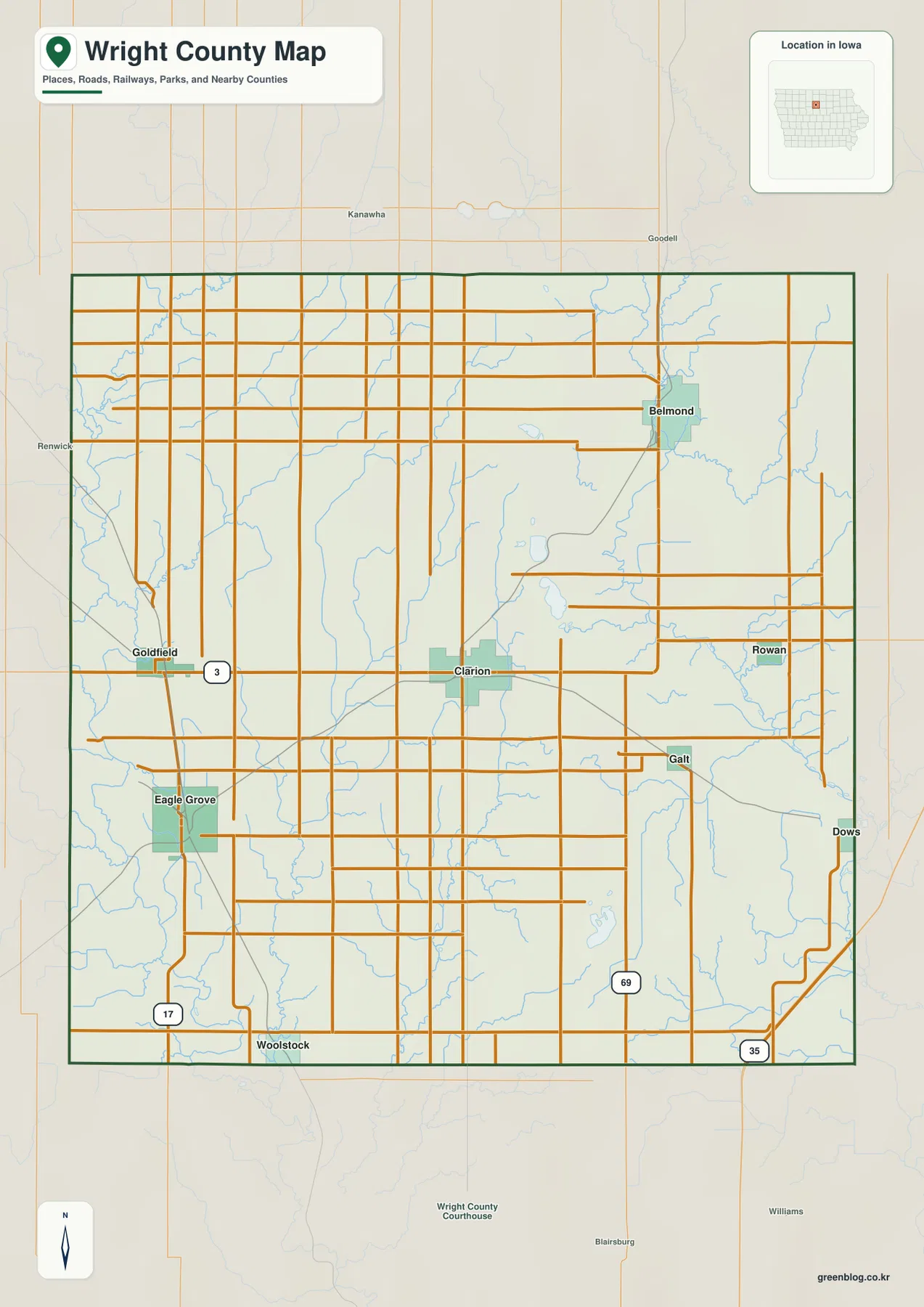
The settlement pattern is easy to see on the general map. Eagle Grove forms a large built-up patch in the southwest, Goldfield sits north of it on Iowa 3, and Clarion occupies the central corridor. Belmond is separated from Clarion by a wide rural area in the northeast, while Rowan lies farther east along the middle portion of the county. Galt appears southeast of Clarion and Dows near the eastern edge, with Woolstock close to the southern boundary. The spacing makes the county feel like a collection of distinct small-town centers rather than one continuous urban area.
That spacing also explains why the road map and the natural-feature maps tell different stories. Local roads often form long straight lines across farmland, but streams curve between them and create shallow valleys that do not follow the grid. A route that looks simple on the highway layer may cross several drainage channels before reaching another town. Switching from the county map to the water and elevation views makes those hidden changes in the land much easier to understand.
Three Main Town Centers Spread Across Wright County
The ranked settlement map highlights Eagle Grove, Clarion, and Belmond as the three largest places in the supplied city index, followed by Goldfield, Dows, and Rowan. The most useful information is not the ranking number itself but the wide spacing between the top three. Eagle Grove sits in the southwest, Clarion near the center, and Belmond in the northeast. That triangular arrangement gives Wright County several local centers instead of placing most activity along one single highway or river corridor.
Eagle Grove’s position is closely tied to the western drainage system. It lies near Boone River tributaries and west of the county’s higher central terrain. Clarion, by contrast, sits near the east–west road spine and serves as the county seat. Belmond occupies a different setting in the northeast, close to the Iowa River system. Goldfield fills part of the gap between Eagle Grove and Clarion, Rowan extends the Iowa 3 corridor eastward, and Dows marks a distinct southeastern location.
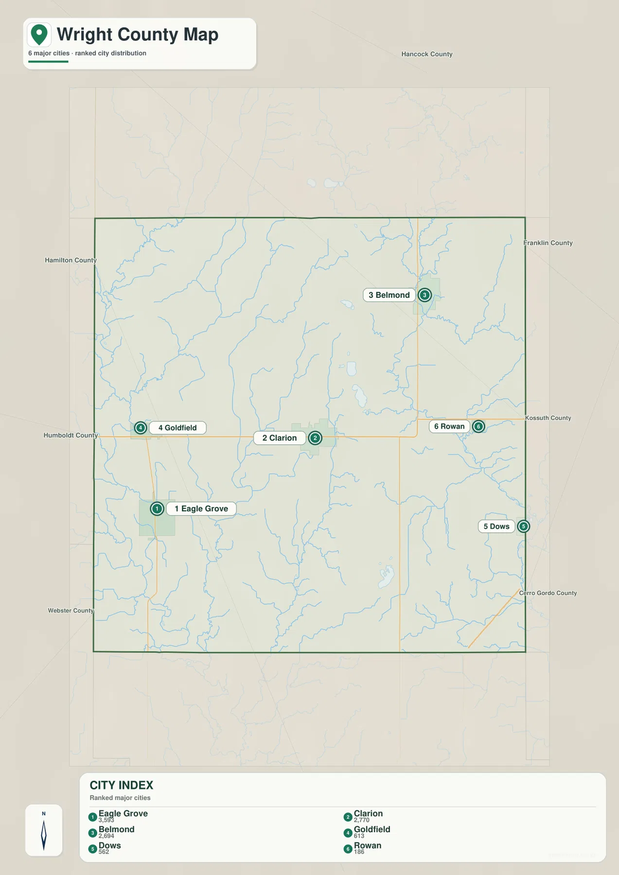
The numbers printed in the city index are best treated as map context rather than a replacement for the latest official population release. Census counts and estimates can be revised on their own schedule. What the map does especially well is remove most secondary detail so that relative direction and spacing are obvious. It is useful for answering questions such as whether Belmond is closer to the northern or southern side, where Dows sits relative to Clarion, or which major town anchors the southwest.
Some smaller names visible on the general county map are not part of the six-place ranked view. Galt and Woolstock are examples. That difference is intentional: one map favors a fuller geographic picture, while the other simplifies the county to its main settlement pattern. Using both together avoids the false impression that an omitted community is absent from the county. The general map is better for complete orientation; the ranked view is better for a quick comparison of the principal towns.
Boone River on the West, Iowa River on the East
The terrain-and-water map reveals a strong west–east contrast. Boone River runs along the western side of Wright County and receives water from smaller channels near Eagle Grove and Goldfield. On the opposite side, the West Branch Iowa River enters the northeast and joins the broader Iowa River system as it continues southward. The center of the county is therefore not organized around one dominant river. Instead, it acts as a higher divide between two outward-draining systems.
Several named tributaries help fill in that structure. Eagle Creek runs through the western-central portion, with Little Eagle Creek and Otter Creek nearby. White Fox Creek extends south through the middle, while Livermore Creek reaches toward the Iowa River on the east. Buck Creek and Sheldon Creek appear along the southern portion of the water map. Their winding courses make a sharp contrast with the straight county roads, showing how drainage follows the shape of the land rather than the survey grid.
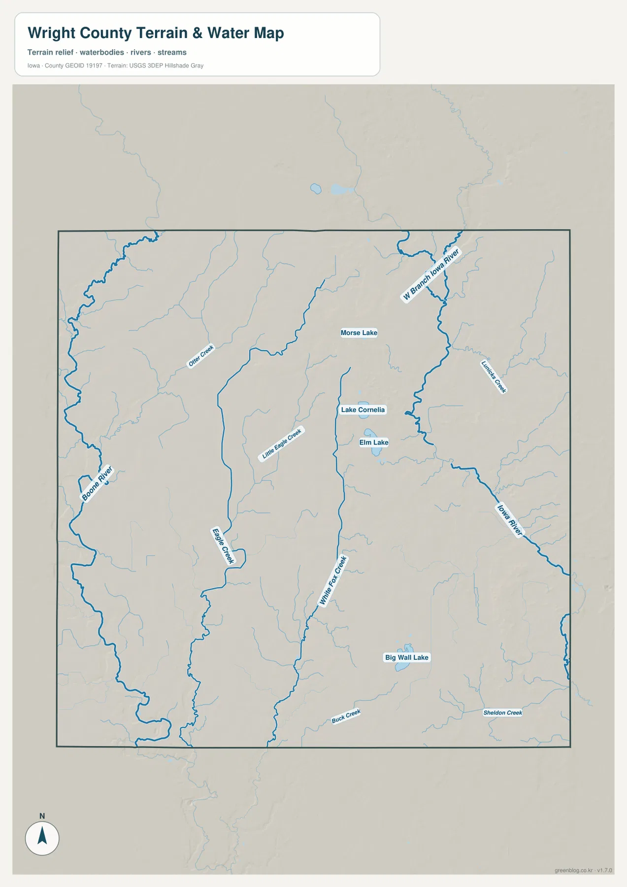
Lakes provide another set of useful reference points. Lake Cornelia and Elm Lake sit close together in the central-eastern part of the county, while Morse Lake lies farther north. Big Wall Lake is separated from that group in the southeast. Wright County Conservation manages parks and outdoor recreation areas across the county, and Lake Cornelia is one of the best-known local water destinations. The map is useful for locating these features, but current water quality, boating restrictions, or access conditions should always be checked with responsible local agencies.
This water map is a general geographic reference, not a flood-risk, parcel, legal-drainage, or navigation product. Boone River and Iowa River levels can change quickly, and small creeks may respond even faster after heavy rain. The map should not be used to decide whether a property will flood, where a legal drainage district begins, or whether a route is currently passable. For those questions, current USGS, county, Iowa DNR, or emergency-management information is more appropriate.
305–393 Meters: A Higher Interior Between Two Low Corridors
The supplied elevation surface reports an actual range of about 305 to 393 meters, with a mean near 357 meters. The broad western side is noticeably lower, especially along Boone River and its tributaries, where green tones trace a network of valleys. Moving toward the center, colors shift through yellow and tan into higher brown ridges. The pattern explains why western streams gather toward Boone River even though the road network above them appears relatively flat and regular.
The eastern half is more complicated than a simple high plateau. Higher ground occupies much of the interior, but the West Branch Iowa River and Iowa River cut a long lower corridor through the northeast and eastern side. Smaller tributaries create additional notches in the uplands. The result is a county with a high central divide and lower drainage routes on both sides rather than a landscape that rises steadily in one direction.
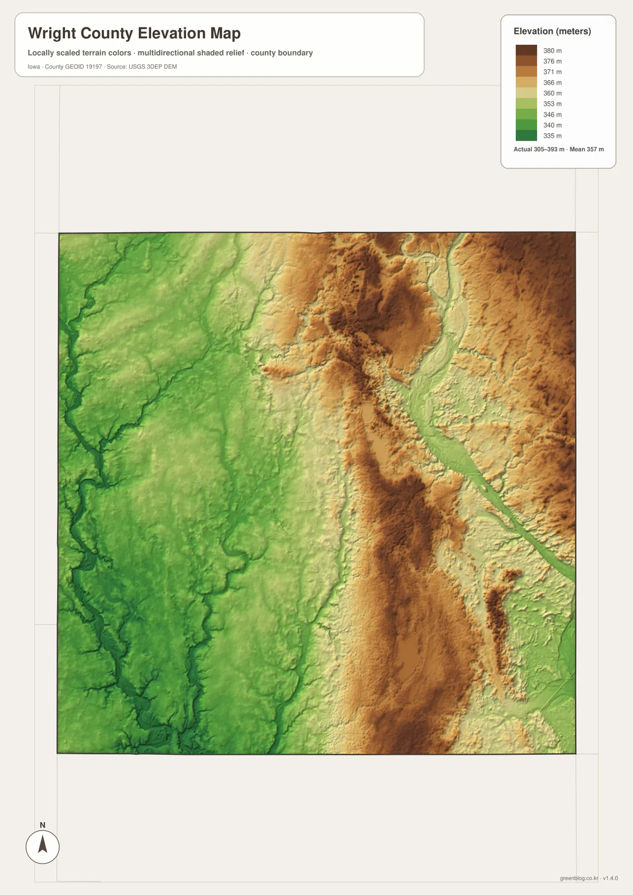
Clarion lies close to the higher middle portion of the county, while the land toward Eagle Grove and the western river system generally drops into greener low terrain. Around Belmond and the northeast, elevated ground is broken by the Iowa River drainage, producing narrow low corridors between higher ridges. Looking at the water and elevation maps together makes these changes much easier to explain than using a single average elevation value for the whole county.
The elevation map is intended for county-scale comparison, not for survey or engineering work. It can show broad valleys, ridges, and relative high and low areas, but it does not establish the exact elevation of a building pad, property corner, roadway grade, or drainage structure. Those tasks require survey-grade data and current local records. For regional learning, route context, or comparing river valleys, however, the map gives a clear visual summary of Wright County’s relief.
Lake Cornelia as a Reference Between Clarion and Belmond
Lake Cornelia is a useful point for connecting all four maps. On the general map, the cluster of small lakes lies east of Clarion and south of Belmond. On the terrain-and-water view, Lake Cornelia and Elm Lake are named clearly, making their relationship to nearby creeks easier to follow. The elevation surface then shows how the lake area sits within a landscape that is higher than the broad Boone River lowlands but still cut by local drainage channels. The settlement map places Clarion and Belmond as the nearest major town references.
Clarion provides another way to compare layers without losing orientation. Start with Iowa 3 and locate Goldfield to the west and Rowan to the east. Then look southwest toward Eagle Grove and northeast toward Belmond to understand the main settlement triangle. Switch to the water map and the empty spaces between those towns become a set of separate creek and river basins. Finally, the elevation map explains why those streams split toward Boone River on one side and the Iowa River system on the other.
For a school project, local-history page, or personal regional study, separating the themes usually produces a clearer result than trying to place every label on one map. Use the county map for roads and complete place orientation, the ranked city map for settlement spacing, the water map for rivers, creeks, and lakes, and the elevation map for high and low terrain. Comparing the same location across two or three of those views is often more informative than reading any one map by itself.
The web images are convenient for quick browsing, but small creek names and road labels can become difficult to read when the page is viewed at normal size. The downloadable JPG originals are better when those details need to be enlarged or printed. Each file covers the same county with a different emphasis, so readers can use only the map needed for a specific task or place all four side by side for a broader comparison.
Frequently Asked Questions
Which map is best for comparing Clarion, Eagle Grove, and Belmond?
Start with the general county map because it keeps Clarion, Eagle Grove, Belmond, Iowa 3, U.S. 69, and the local road network in one frame. If you only want to compare the relative spacing and prominence of the main towns, the ranked settlement map provides a simpler second view without most of the secondary road detail.
Where is Wright County’s strongest elevation contrast?
The clearest contrast is between the low Boone River side in the west and the higher central interior. The supplied elevation map ranges from about 305 to 393 meters. The east also contains a lower corridor where the West Branch Iowa River and Iowa River cut through higher terrain, so the county is best understood as a high interior between two main drainage systems.
Can the Lake Cornelia and river map be used for flood or property decisions?
No. The terrain-and-water map is a general geographic reference for Lake Cornelia, Boone River, Iowa River, Eagle Creek, and other named features. Current flood stages, legal property boundaries, drainage rights, road access, water quality, and boating restrictions should be checked with USGS, Wright County Conservation, Iowa DNR, or another responsible agency.
Map File Information
The ZIP contains the high-resolution JPG originals corresponding to the Wright County county, city, terrain-and-water, and elevation maps shown on this page.
- File Type: ZIP containing 4 JPG files
Related Maps
Sources and References
For county administration and local information, see the official Wright County website and Wright County Conservation. Road and city-map context is available from Iowa DOT Wright County Maps. Boundary and base geography can be checked through the U.S. Census Bureau TIGER/Line files, water features through USGS National Hydrography, and terrain through the USGS 3D Elevation Program.
Green Map creates custom-edited map images using open geographic data sources such as geoBoundaries, Natural Earth, OpenStreetMap, and government open data.
These maps are edited visual materials, not raw data files, and are provided for education, documents, presentations, and graphic reference.