Wheatland County in central Montana is organized around Harlowton, the Musselshell River valley, broad rolling country, and much higher terrain along the western and northwestern edges. Once Harlowton, Judith Gap, Two Dot, and Shawmut are located on the road map, the water and elevation layers explain why the central valley carries so many of the county’s principal routes and settlements.
This page includes a county boundary and road map, a major-city map, a terrain and water map, and an elevation map. You can view each map in the article and download the four original high-resolution JPG files together in one ZIP for printing, classroom work, or personal reference.
Table of Contents
Harlowton connects the county’s main roads and nearby communities
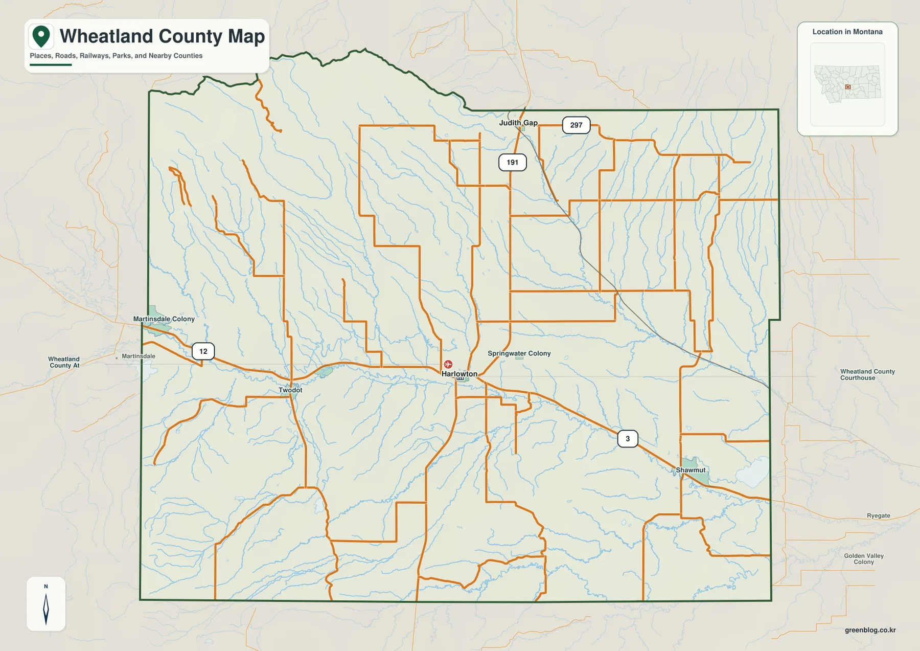
Harlowton is the clearest anchor on the general county map. U.S. 12 approaches from the west through the Two Dot and Martinsdale area, while U.S. 191 runs north from Harlowton toward Judith Gap. Route 3 leaves the central area toward Shawmut in the southeast. With those three routes in view, Harlowton becomes a practical reference point for understanding movement across a county that otherwise has a sparse rural road network.
Judith Gap appears near U.S. 191 in the northern part of the county, with a road marked 297 nearby. Two Dot lies west of Harlowton along the U.S. 12 corridor, and Martinsdale Colony and Martinsdale appear close to the western boundary. Shawmut is southeast of Harlowton near Route 3. The map also labels Springwater Colony, giving a useful sense of how small settlements are distributed beyond the two ranked cities.
The county boundary itself is irregular. The northwestern edge bends around mountain terrain, while several central-western and southern sections step in and out rather than following one straight line. Judith Basin and Fergus Counties are to the north, Meagher and Sweet Grass Counties lie toward the west, and Golden Valley County is on the eastern and southeastern side. Keeping those neighboring labels visible helps place Wheatland County within central Montana.
Harlowton and Judith Gap form the two-city index
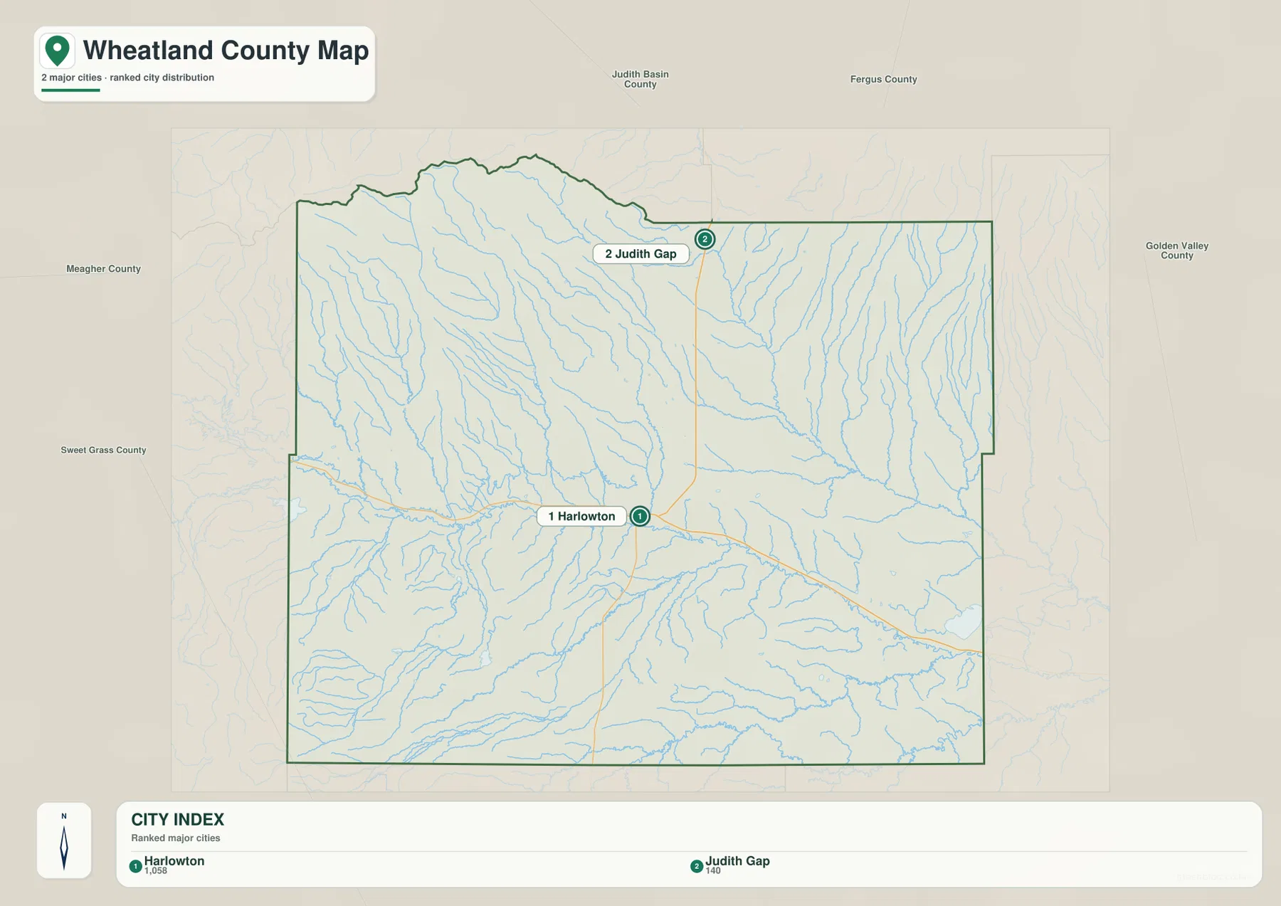
The city distribution map ranks Harlowton first and Judith Gap second. It is a deliberately simple view, separating the county’s two principal city points from the smaller communities shown on the general map. Unlike some city-index maps, this one does not include a connector line or straight-line mileage between the two places, so it is best used to compare their positions rather than to estimate distance.
Harlowton sits in the lower Musselshell River corridor where major roads converge. Judith Gap is farther north on U.S. 191, closer to higher terrain and the transition toward the county’s northern uplands. Comparing the city map with the elevation layer makes the difference clear: the county seat occupies a broad lower valley, while the landscape becomes more elevated and broken toward Judith Gap and especially to its northwest.
The Wheatland County government identifies Harlowton as the county seat. Its official history notes that Wheatland County was established in 1917 from portions of Meagher and Sweet Grass Counties. Those facts fit the map well: Harlowton sits near the center of the present county and at the meeting point of important east-west and north-south routes, while Judith Gap serves as a useful northern reference point.
The Musselshell River gathers streams from both mountain and prairie country
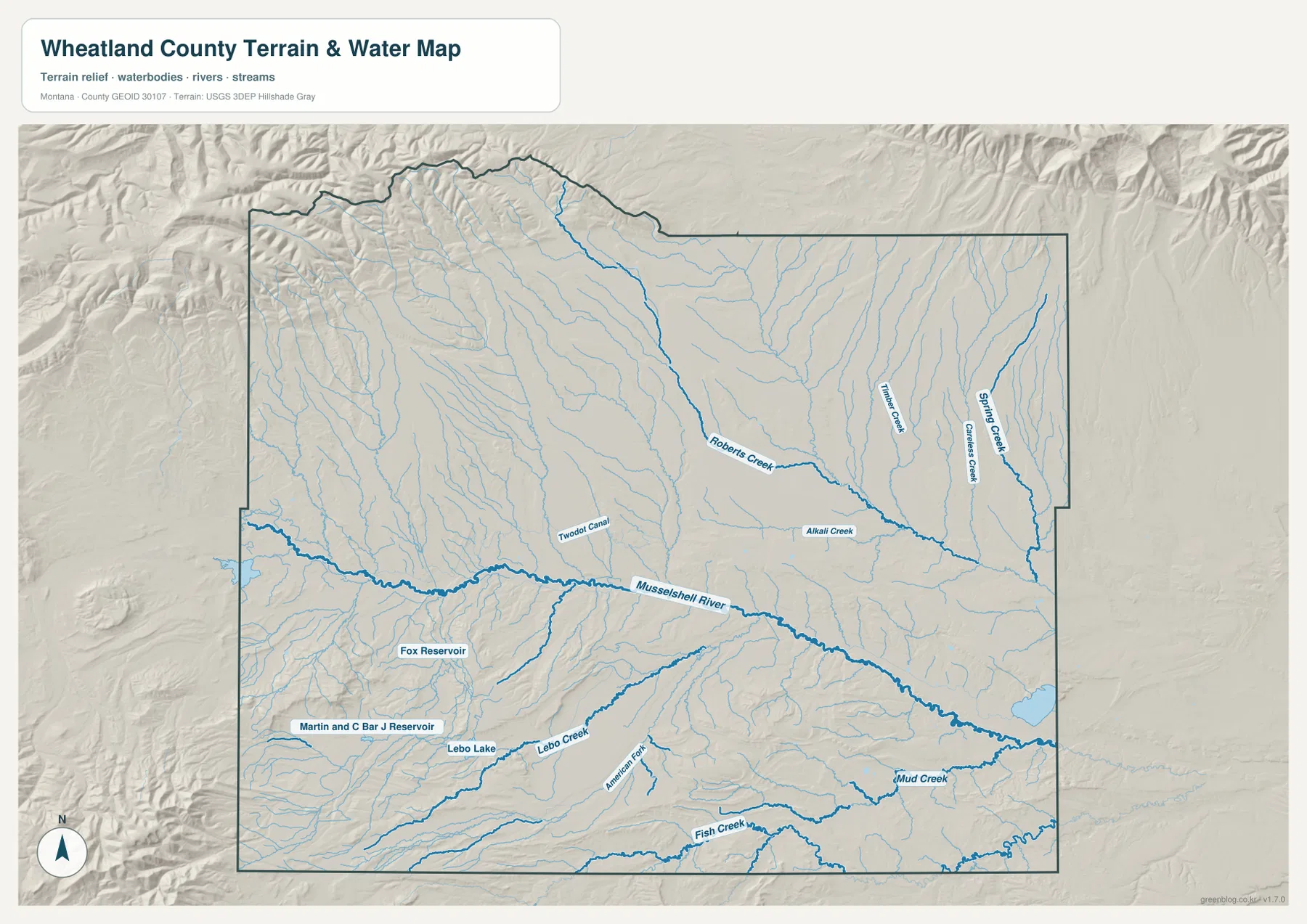
The Musselshell River dominates the water map. It enters from the west, passes through the Two Dot and Harlowton area, and continues southeast across the county. The river occupies a relatively low corridor that is easy to match with the road map, where U.S. 12 follows a similar central route for part of the distance. This relationship between the valley floor, the highway, and the main population center is one of the most distinctive geographic patterns in Wheatland County.
North of the river, Roberts Creek descends toward the central drainage, while Timber Creek, Creamery Creek, and Spring Creek run through the eastern half of the county. Alkali Creek is labeled closer to the center, and Two Dot Canal follows the western valley area. These named waterways show how numerous smaller drainages carry water from higher northern ground toward the Musselshell system.
South of the river, American Fork and Lebo Creek stand out, with Fish Creek and Mud Creek farther south and east. The map also labels Fox Reservoir, Lebo Lake, and Martin and C Bar J Reservoir. Those smaller water bodies are useful orientation points, but the map is a geographic overview rather than a floodplain, water-right, parcel-boundary, or navigation product. Legal or engineering questions should be checked against current agency records.
Elevation changes from a 1,138-meter valley floor to 2,659-meter high country
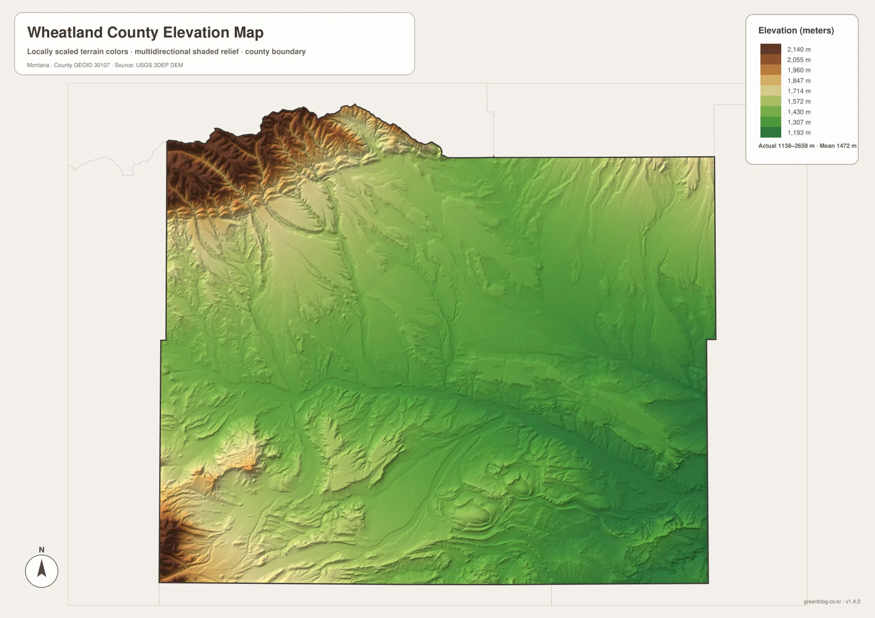
The elevation map reports an actual range of about 1,138 to 2,659 meters, with a mean near 1,472 meters. The lowest green terrain follows the broad central valley and extends eastward from the Harlowton area. In contrast, the northwestern corner rises sharply into dark brown high country, and another elevated block appears along the southwestern edge.
The northwestern mountains are deeply cut by narrow valleys, with many small streams descending toward lower ground. The southwestern high terrain is also rugged, although the central and southeastern parts of the county are generally lower and more open. These relief differences help explain why some roads are relatively direct across the valley floor while routes near the mountain margins bend around slopes and drainage channels.
The color scale is local to Wheatland County, so a similar color on another county map may represent a different absolute elevation. The surface has also been generalized for county-wide visualization. It should not be treated as survey-grade information for construction, drainage design, property boundaries, or other work that requires precise elevations; those uses require original USGS data and, where necessary, field survey measurements.
Roads favor the Musselshell corridor while mountain edges remain more rugged
Placing the road and elevation maps side by side reveals how strongly transportation follows the lower landscape. U.S. 12 moves from Two Dot through Harlowton along the same broad corridor occupied by the Musselshell River. Rather than crossing the highest western terrain directly, the main east-west route uses the lower valley and connects the communities that developed there.
U.S. 191 tells a slightly different story. It leaves Harlowton and heads north toward Judith Gap, gradually climbing out of the central lowland. Near Judith Gap, higher terrain begins to appear more prominently to the northwest, while the country east of the highway remains more open. The transition helps explain why Harlowton and Judith Gap feel like two different geographic settings even though both are on the same north-south route.
Montana State University Extension describes Wheatland County as a largely agricultural and ranching county associated with the Crazy, Little Belt, and Big Snowy mountain regions and the Musselshell River. The supplied maps support that broad description visually: open valley and rolling country occupy much of the interior, while steep high ground frames parts of the west and northwest. The county is therefore better understood as a valley-and-upland landscape than as a uniform plain.
Finding Two Dot, Shawmut, and the Martinsdale side of the county
Two Dot is easiest to find by following U.S. 12 west from Harlowton along the Musselshell corridor. Several smaller roads and streams converge around this section, and the river remains a useful landmark. Martinsdale and Martinsdale Colony are farther west near the county edge, where the terrain rises and the boundary approaches Meagher County. Keeping both the road and county outline visible prevents locations just outside Wheatland County from being confused with places inside it.
Shawmut lies southeast of Harlowton near Route 3, in lower and more open terrain than the high northwestern corner. The route follows the general direction of the central valley before continuing into a more gently dissected landscape. Judith Gap, by contrast, is found simply by following U.S. 191 north. Using Harlowton as the starting point for all three directions is easier than trying to memorize the county’s many minor roads.
A county created in 1917 with a railroad-rooted seat
Wheatland County was established on February 22, 1917, from parts of Meagher and Sweet Grass Counties, according to the county government. The county name refers to the extensive wheat-growing country in its central area, and Harlowton became the county seat. That history adds context to the modern map because Harlowton still appears as the dominant administrative and transportation center.
MSU Extension also notes Harlowton’s railroad roots, including its role as an important division point for the Milwaukee Road. The maps on this page focus on present-day roads, waterways, and terrain rather than railroad history, but the historical background helps explain why Harlowton grew larger than the surrounding rural communities. Judith Gap, Two Dot, and Shawmut provide contrasting examples of smaller places spread across the same county.
Which Wheatland County map is most useful for your task?
Use the general county map when the main question is where a community or road sits relative to the county boundary. Harlowton and the U.S. 12, U.S. 191, and Route 3 corridors make it easy to orient Two Dot, Judith Gap, and Shawmut. The city map is cleaner when you only need the relative positions of Harlowton and Judith Gap without the surrounding road detail.
For physical geography, start with the Musselshell River on the terrain and water map, then trace Roberts Creek, American Fork, Lebo Creek, and the other tributaries into the surrounding uplands. The elevation map adds the missing vertical context by showing how sharply the land rises in the northwest and southwest. Together, those two views explain much of the road pattern and settlement distribution visible on the general map.
Frequently Asked Questions
Why is there no distance line between Harlowton and Judith Gap on the city map?
The supplied city map ranks and locates the two major cities but does not include a straight-line connector or mileage label. Rather than adding an unsupplied estimate, this article uses the map to describe their north-south relationship along U.S. 191. For driving distance, use a current routing service.
Where is the lowest terrain in Wheatland County?
The elevation map places the lowest green terrain along the central Musselshell River corridor and around Harlowton. Higher ground rises sharply in the northwest and southwest, and the map’s reported county-wide elevation range is about 1,138 to 2,659 meters. The colors are intended for comparison within this county, not between separate county maps.
Can the water map be used for flood or property-boundary decisions?
No. It is a geographic reference showing the relative positions of the Musselshell River, tributaries, lakes, and reservoirs. Flood determinations, water rights, parcel boundaries, navigation, construction, and engineering decisions require current records from the appropriate county, state, or federal agency.
Map File Information
The ZIP contains the original high-resolution JPG files for the county road and boundary map, major-city map, terrain and water map, and elevation map.
- Included Files: Use only the versions confirmed in the article and supplied images
- File Type: Use the confirmed download contents
- Intended Use: Printing, education, presentations, and map-based projects
Related Maps
Sources and references
- Wheatland County official website
- Montana State University Extension – Wheatland County
- U.S. Census Bureau TIGER/Line Shapefiles
- USGS National Hydrography
- USGS 3D Elevation Program
These maps are intended for geographic reference. For legal boundaries, land ownership, flood determinations, water rights, construction, surveying, or other decisions requiring current authoritative information, consult Wheatland County and the responsible state or federal agency.
Green Map creates custom-edited map images using open geographic data sources such as geoBoundaries, Natural Earth, OpenStreetMap, and government open data. These maps are edited visual materials, not raw data files, and are provided for education, documents, presentations, and graphic reference.