Big Horn County covers a broad part of southeastern Montana where river valleys, open uplands, and rugged mountain country sit within the same county boundary. Hardin provides the easiest northern reference point, while Crow Agency, Lodge Grass, and Wyola continue south along the Little Bighorn corridor. To the southwest, Bighorn Lake enters a much steeper landscape, and the eastern side of the county opens toward Busby, Muddy, Rosebud Creek, and the Tongue River drainage. The maps on this page separate those features into boundary-and-road, city, terrain-and-water, and elevation views. High-resolution JPG versions of all four maps are available in the download box below.
A useful way to approach the county is to begin with Hardin and then follow the major routes and valleys outward. I-90 and U.S. 212 appear near Hardin, Highway 47 runs north, and the main southbound corridor leads toward Crow Agency and Lodge Grass. Pryor, St. Xavier, and Fort Smith sit well to the west, while Busby and Muddy occupy the eastern side. Because the county boundary is irregular and the terrain changes sharply from one side to another, straight-line proximity on a small map does not always translate into a simple road trip.
Table of Contents
Start with Hardin, then follow the roads south
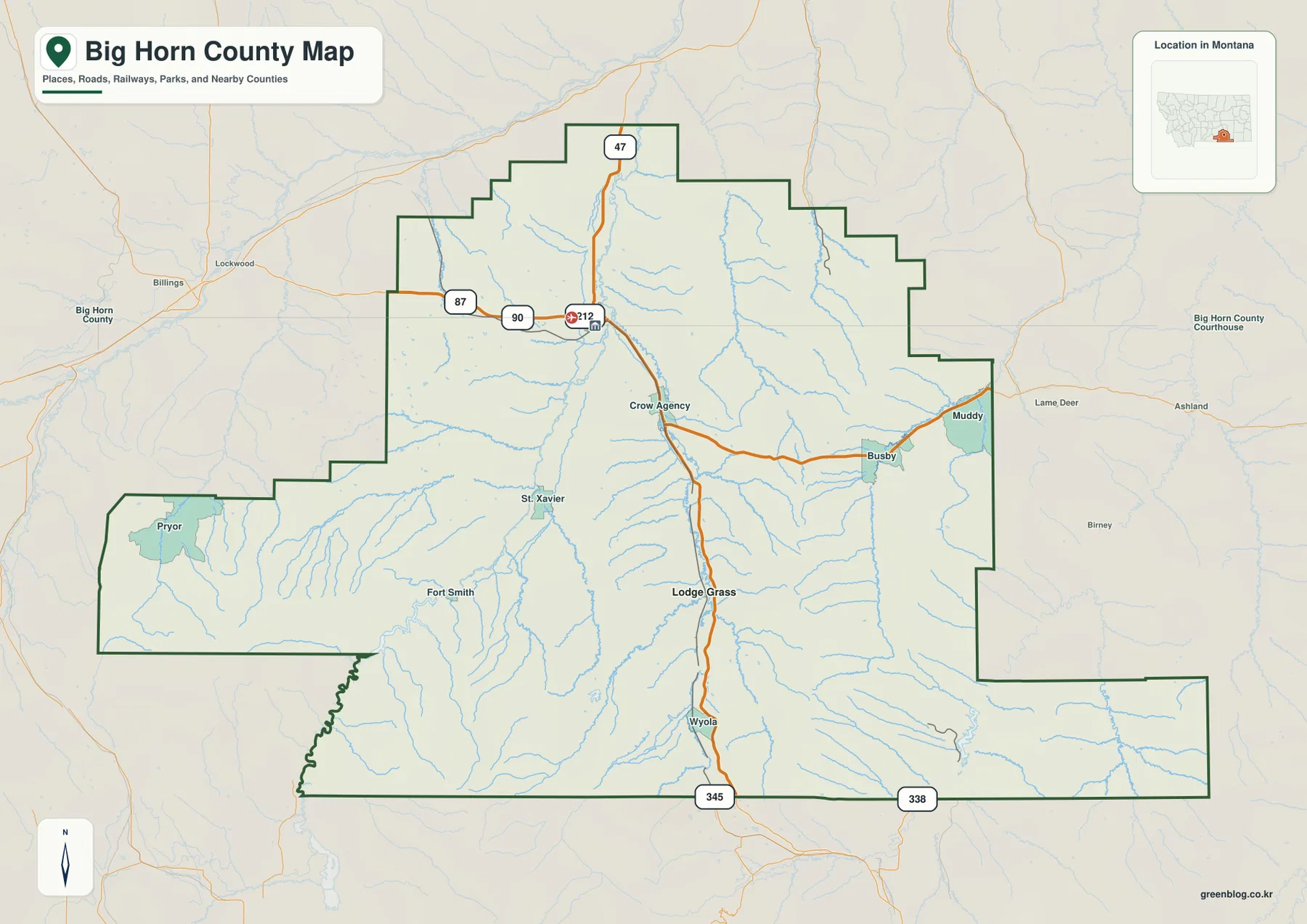
On the general county map, Hardin is the clearest anchor for orientation. The city sits in the north-central portion of Big Horn County, close to the junction of I-90 and U.S. 212 as shown on the map. Highway 47 continues north from this area. South of Hardin, Crow Agency appears first, followed farther south by Lodge Grass and then Wyola. This sequence makes the central north-south corridor easy to recognize even before looking at the river map.
The western and eastern sides of the county are less directly tied to that corridor. Pryor lies far to the west in the county’s projecting western section, with St. Xavier and Fort Smith closer to the Bighorn River side. Busby and Muddy are placed near the eastern boundary. Their roads connect through a different set of valleys, so they should not be read as simple extensions of the Hardin-to-Lodge Grass route. The county outline itself has several steps and projections, which is one reason the map is useful for separating nearby-looking places that actually sit in different parts of the county.
Route labels near the southern edge include 345 and 338, while 87 appears toward the northwest. These route numbers are helpful for broad orientation, but the map is not a live navigation service. Construction, closures, seasonal restrictions, and travel times can change. For an actual drive, use this map to understand where communities sit within the county and then confirm the current route with an up-to-date transportation source.
Hardin and Lodge Grass provide a simple city-to-city reference
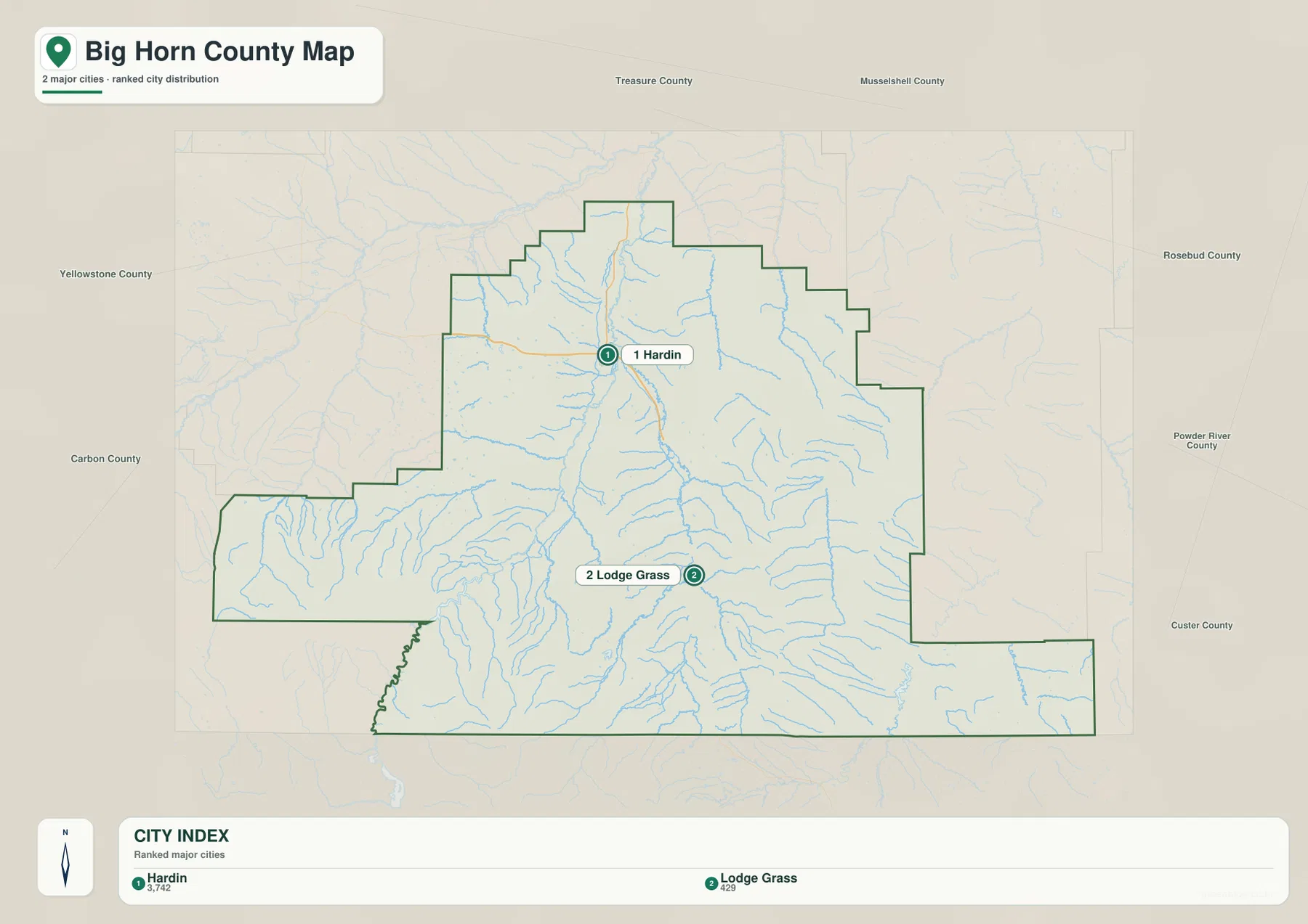
The city map intentionally removes much of the detail found on the general map and highlights only two ranked places: Hardin and Lodge Grass. Its city index lists Hardin at 3,742 and Lodge Grass at 429. Those numbers are values printed on the supplied map, not a promise that they match the newest population estimates. Anyone who needs current population figures should consult the latest U.S. Census Bureau releases rather than treating the map index as a live demographic source.
The simplified view is useful because it shows how far apart the two main markers are within the county. Hardin sits in the north-central area, whereas Lodge Grass is much farther south. When the city map is compared with the full county map, Crow Agency can be placed between them and Wyola can be located south of Lodge Grass. That comparison gives a quick sense of the county’s long north-south span without crowding the page with every smaller community.
No road mileage or straight-line distance is printed between Hardin and Lodge Grass on this city map. The spacing should therefore be read as a location reference rather than as a travel-time estimate. In a county with large valleys, uplands, and fewer direct cross-county routes, the practical driving distance can depend heavily on which valley and highway provide the connection.
The Little Bighorn River explains much of the central settlement pattern
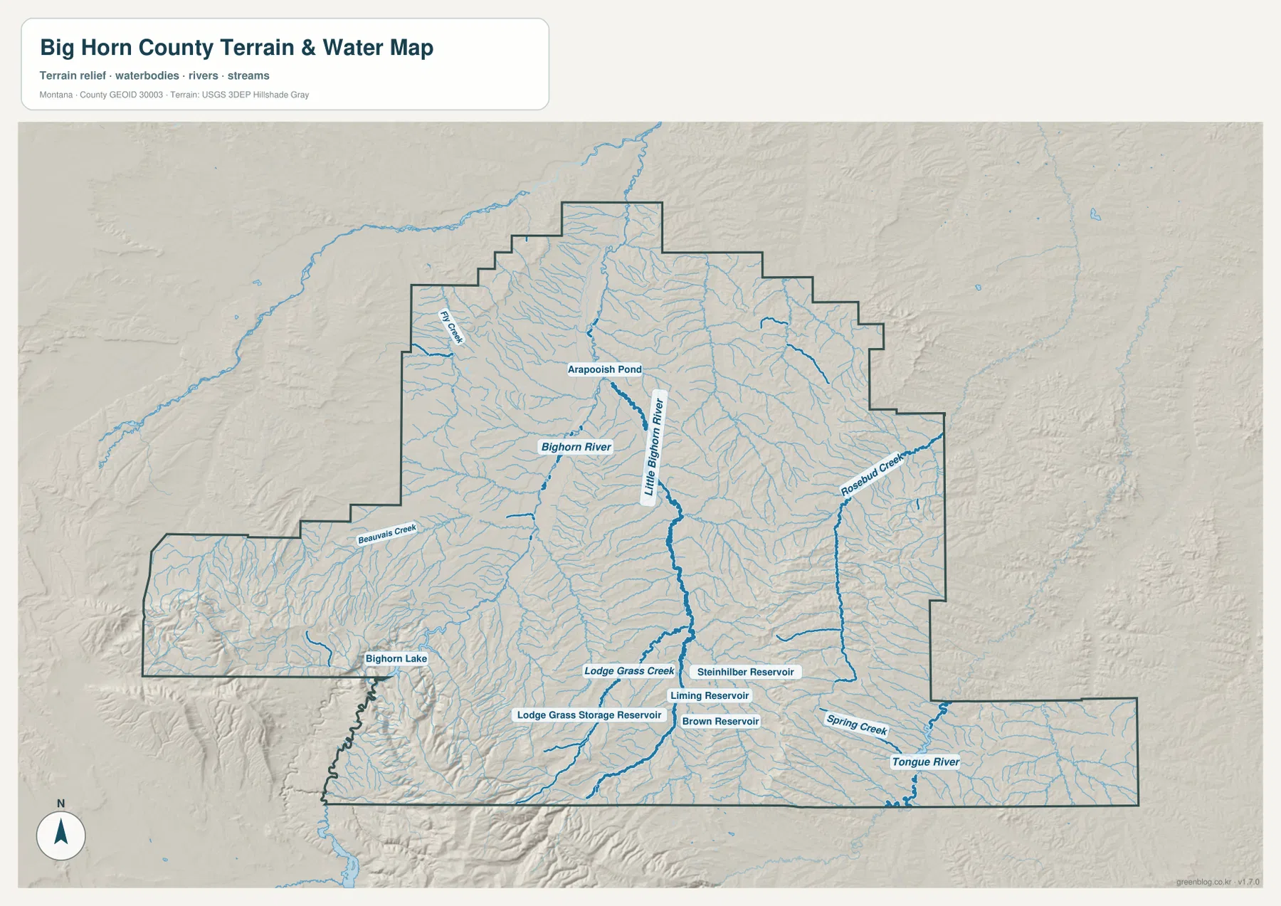
The terrain-and-water map makes the Little Bighorn River one of the most important features for understanding the county. It runs north through the central part of the map, receiving numerous smaller streams along the way. Lodge Grass Creek joins the same broad valley system in the south-central area. When this water map is compared with the community map, the placement of Crow Agency, Lodge Grass, and Wyola along the central corridor becomes easier to understand.
The Bighorn River provides another major reference farther west and north. Around the center of the county, the two large river systems occupy broad lower corridors separated by higher ground. Farther east, Rosebud Creek forms a distinct drainage, while Spring Creek and the Tongue River appear in the southeastern section. Busby and Muddy sit closer to this eastern side, so their geographic context is different from the communities aligned with the Little Bighorn River.
Several smaller names help with local orientation. Beauvais Creek appears on the western side, Fly Creek is labeled in the northwest, and Arapooish Pond is shown north of the central river system. These features are most useful after the major rivers have been identified. Rather than trying to memorize every tributary at once, readers can first locate the Bighorn and Little Bighorn rivers, then use the smaller creeks and reservoirs as local reference points.
Bighorn Lake marks a very different southwestern landscape
Bighorn Lake occupies the southwestern part of the county and sits beside some of the most rugged terrain shown in the package. The lake continues through Bighorn Canyon country near the Montana-Wyoming line, while its northern reach connects with the Bighorn River system near Fort Smith. The National Park Service manages Bighorn Canyon National Recreation Area, so current access, boating, trail, and visitor information should be checked with the park when planning an actual trip.
The water map also labels several much smaller reservoirs in the south-central portion of Big Horn County, including Lodge Grass Storage Reservoir, Liming Reservoir, Brown Reservoir, and Steinhilber Reservoir. These are visually minor compared with Bighorn Lake, but they are useful landmarks around Lodge Grass Creek and nearby tributaries. On the eastern side, Rosebud Creek, Spring Creek, and the Tongue River create a separate set of water references that has little resemblance to the canyon-and-lake setting in the southwest.
This map is designed to show where rivers, streams, reservoirs, and major terrain features are located relative to the county boundary. It is not a flood-hazard map, a navigation chart, a water-rights record, or a substitute for boating and fishing regulations. For any activity where access, depth, legal boundaries, or current water conditions matter, consult the responsible federal, tribal, state, or local authority.
Elevation rises sharply toward the southwest
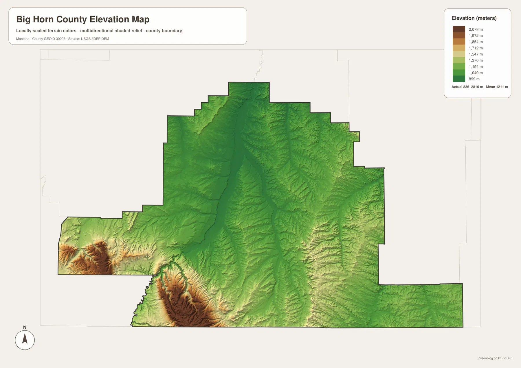
The elevation map reports an actual county range of about 836 to 2,816 meters, with a mean elevation of about 1,211 meters. The broad central and northern river valleys appear mainly in the lower green tones, while the southwestern part of the county shifts toward higher yellow, brown, and dark-brown terrain. The nearly 2,000-meter difference between the lowest and highest values is a strong reminder that Big Horn County includes both open valley floors and substantial mountain relief.
The strongest high-elevation colors occur near and south of Bighorn Lake along the southwestern edge. Ridges and deeply cut valleys are packed closely together there, producing a much rougher shaded surface than in the central Little Bighorn corridor. The western projection near Pryor also contains elevated terrain, but the biggest concentration of high relief is in the southwest.
Eastern Big Horn County does not show the same continuous block of very high terrain, yet it is far from flat. Numerous ridges and stream-cut valleys appear around Rosebud Creek and toward the Tongue River. Looking back to the general county map, many roads and communities occupy the lower corridors rather than the highest ridges. The elevation map therefore adds useful context to the settlement and transportation map without being a survey-grade source.
Use each map for a different question
For a first look at Big Horn County, the general county map is the most useful starting point. It places Hardin, Crow Agency, Lodge Grass, Wyola, Pryor, Fort Smith, St. Xavier, Busby, and Muddy within the same boundary and includes the major highway labels. It is the best choice for answering basic questions such as which community lies north or south of another and which side of the county a place occupies.
The city map is intentionally simpler and works best when the comparison is only between Hardin and Lodge Grass. The terrain-and-water map is more useful for locating the Little Bighorn River, Bighorn River, Bighorn Lake, Rosebud Creek, Tongue River, and the labeled reservoirs. If the question is why one part of the county appears more mountainous than another, the elevation map gives the clearest answer by separating the low river corridors from the high southwestern terrain.
The WebP images embedded in the article are convenient for quick viewing, while the downloadable JPGs are better for printing or zooming into smaller labels. The package is most useful as a geographic reference rather than as a live operational map. Road conditions, park access, administrative information, and regulations can change, so time-sensitive decisions should always be checked against current official sources.
Frequently Asked Questions
Which map is best for seeing Hardin, Crow Agency, and Lodge Grass together?
Use the general county map. It shows all three communities in the same view along with the principal roads and the county boundary. Hardin is north of Crow Agency, and Lodge Grass is farther south. The city map is cleaner but highlights only Hardin and Lodge Grass.
Are Bighorn Lake and the Little Bighorn River in the same part of the county?
No. Bighorn Lake is in the rugged southwestern portion of Big Horn County, while the Little Bighorn River runs north through the central corridor. The terrain-and-water map is the easiest place to compare the two and see how different the southwest lake-and-canyon area is from the central river valley.
Can the 836–2,816 meter elevation range be used as survey data?
No. The elevation map is a county-wide reference for comparing lower valleys with higher terrain, not a substitute for site-specific surveying, engineering, or construction data. For precise elevations, consult an authoritative elevation dataset such as the USGS 3D Elevation Program.
Map File Information
Download the Big Horn County county, city, terrain-and-water, and elevation maps as the original high-resolution JPG files.
- Included Files: county map, city map, terrain and water map, elevation map
- File Type: ZIP containing 4 JPG files
Related Maps
Sources and References
Administrative background can be checked through the official Big Horn County government website and the county About Us page. Information about Bighorn Lake, Bighorn Canyon, and the surrounding recreation area is available from the U.S. National Park Service.
Boundary and road-reference data are available through U.S. Census Bureau TIGER/Line Shapefiles. Water features can be checked against USGS National Hydrography, and elevation data are available through the USGS 3D Elevation Program.
Green Map creates custom-edited map images using open geographic data sources such as geoBoundaries, Natural Earth, OpenStreetMap, and government open data. These maps are edited visual materials, not raw data files, and are provided for education, documents, presentations, and graphic reference.