Shannon County lies in the rugged southeastern Missouri Ozarks, where Eminence, Winona, and Birch Tree are separated by deeply cut river valleys and long forested ridges. Route 19 links Eminence with Winona, U.S. 60 crosses the southern county through the Birch Tree–Winona corridor, and Route 106 extends west from Eminence. The Jacks Fork and Current rivers dominate the central and eastern landscape, making terrain as important as roads when reading the county. High-resolution map files are available for download in the section below.
This page separates those features into a general county map, a city-connections map, a terrain-and-water map, and an elevation map. High-resolution JPG originals of all four can be downloaded together in one ZIP for enlargement, A3 printing, classroom materials, reports, or personal reference.
Table of Contents
Route 19 ties Eminence to Winona through rugged Ozark terrain
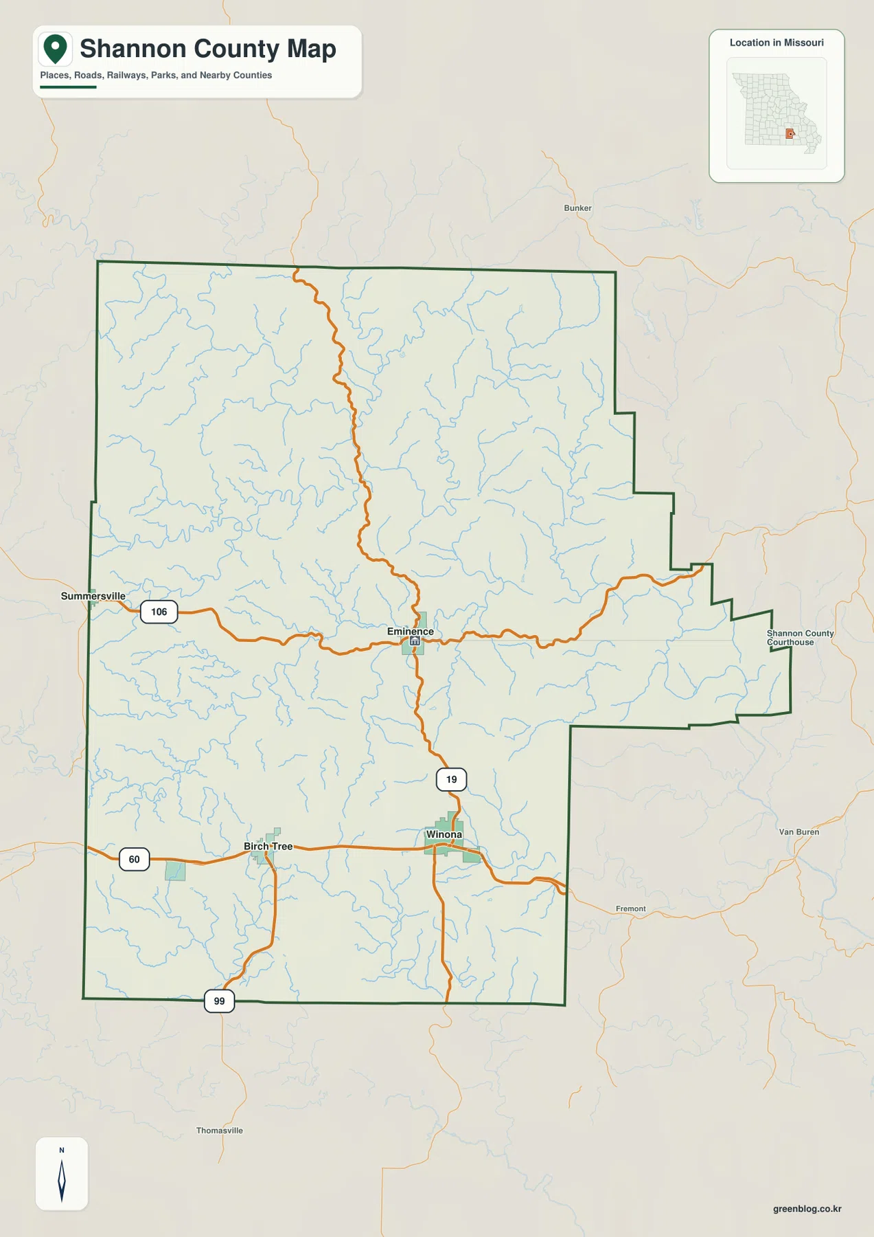
Eminence is the best central reference on the general map. Routes 19 and 106 meet near the community, placing it between the northern uplands and the southern Winona corridor. It is also the county seat: the Missouri Association of Counties lists multiple Shannon County offices in Eminence, making the town both a geographic and administrative anchor.
Route 19 runs south from Eminence toward Winona and creates the clearest north-south road line through the county. Around Winona, U.S. 60 provides the major east-west connection and continues toward Birch Tree in the west. The road corridor is easier to follow than the dense network of small streams surrounding it, but it still bends with the hills and valleys.
Birch Tree lies west of Winona near U.S. 60, with Route 99 extending toward the southern boundary. Summersville appears outside the western county edge along the Route 106 approach to Eminence. These places help organize the southern half before the road network becomes much sparser across the northern uplands.
Northern Shannon County has relatively few large settlement labels. Roads often wind along ridges or descend through narrow valleys rather than forming a simple grid. Starting with Routes 19, 60, and 106, then adding the smaller roads, makes the relationship between transportation and terrain much easier to understand.
Birch Tree and Eminence lie 9 to 10 miles from Winona in straight-line distance
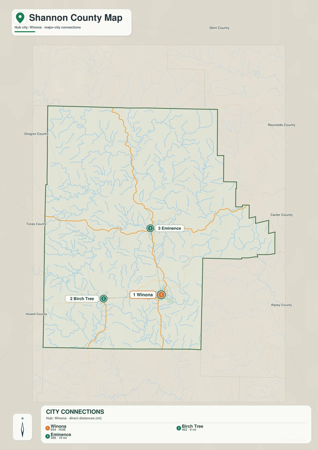
The city-connections map uses Winona as its hub. Birch Tree is shown about 9 miles to the west, while Eminence is about 10 miles to the north in straight-line distance. These are direct point-to-point measurements rather than driving mileage.
The city index labels Winona with 854, Birch Tree with 402, and Eminence with 388. Winona is the largest of the three highlighted places on this map, but each community serves a different geographic role: Winona anchors the southern road network, Birch Tree the southwest, and Eminence the central river country.
Actual road trips are longer than the connector lines suggest because the county is crossed by deep valleys and high ridges. Route 19 between Winona and Eminence bends through the terrain, and the Birch Tree side also follows the shape of local drainage. The city map is therefore best for relative position, while the general map is better for route planning.
Once the three communities are located, the rest of Shannon County becomes easier to interpret. Winona provides a southern road framework, Eminence anchors the Jacks Fork area, and Birch Tree identifies the western U.S. 60 corridor. Those references carry over directly to the water and elevation maps.
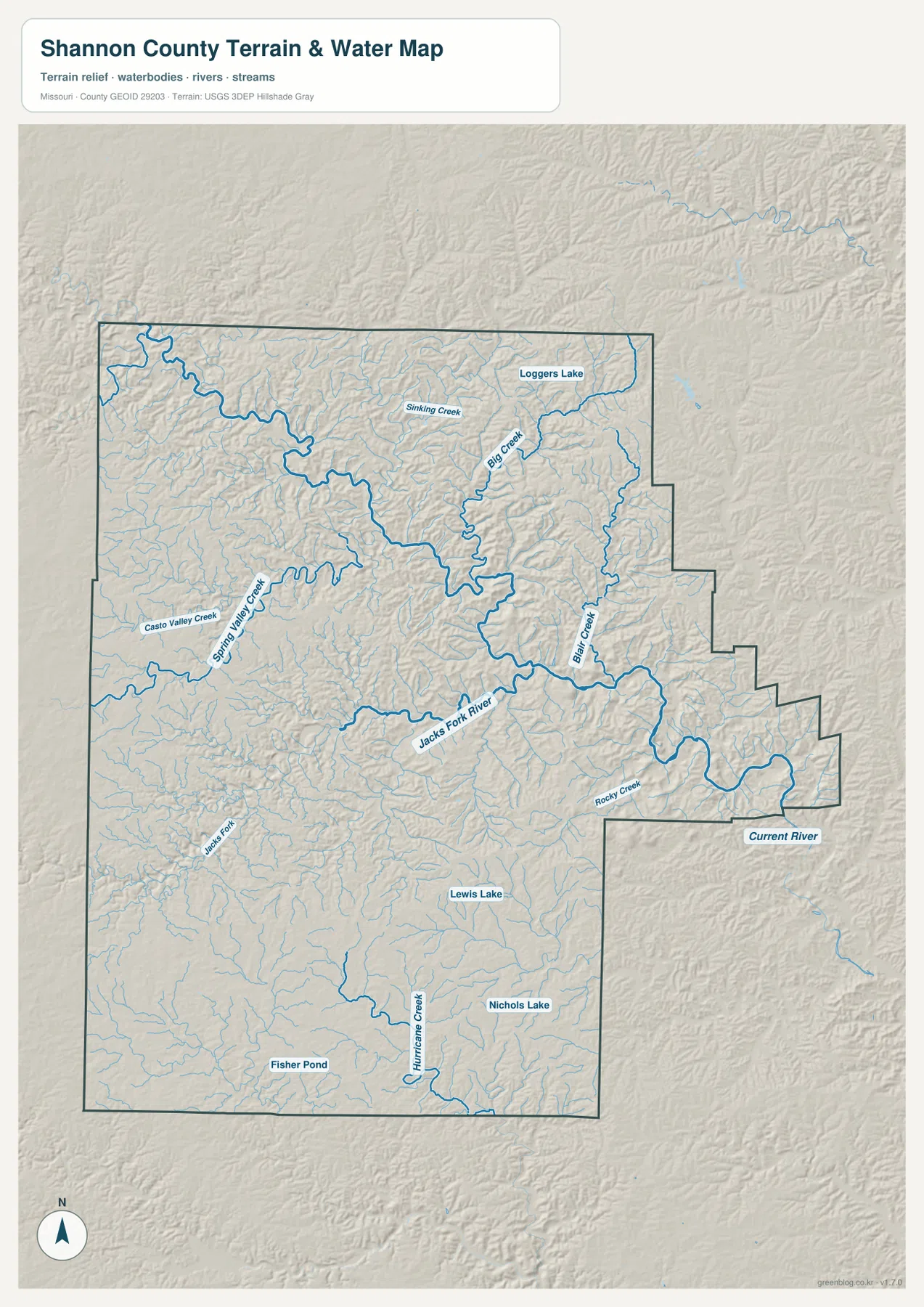
Jacks Fork and Current River carve the county’s deepest valleys
The Jacks Fork and Current River are the dominant features on the terrain-and-water map. Jacks Fork winds across the western and central county before heading east of Eminence, while the Current River occupies a major valley on the eastern side. The National Park Service identifies both rivers as the core waterways of Ozark National Scenic Riverways.
The connection between the two rivers is one of Shannon County’s most distinctive geographic features. National Park Service watershed information states that Jacks Fork joins the Current River about five air miles east-northeast of Eminence. That confluence explains why the eastern-central portion of the water map contains such a broad and deeply cut valley system.
Smaller tributaries reinforce the same pattern. Sinking Creek and Big Creek cross the north, Blair Creek descends through the east, and Rocky Creek reaches the Jacks Fork system farther south. Spring Valley Creek and Casto Valley Creek divide the western uplands, while Hurricane Creek creates another long valley in the southern county.
Loggers Lake appears in the northeast, and Lewis Lake, Nichols Lake, and Fisher Pond provide smaller southern landmarks. These waterbodies are minor compared with the river system, but they help identify different parts of a county where settlement labels are sparse and the stream network is extremely dense.
Much of the Jacks Fork and Current River corridor lies within Ozark National Scenic Riverways. This map is intended for geographic reference rather than current river-stage, flood, navigation, or legal-boundary decisions. For present conditions and river use, the National Park Service and USGS should be consulted directly.
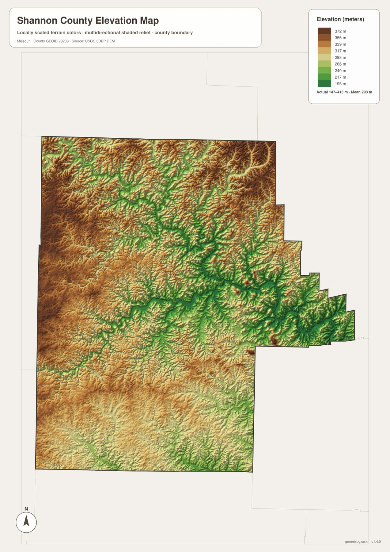
Elevation ranges from about 147 to 413 meters
The elevation map reports an actual range of roughly 147 to 413 meters and a mean near 298 meters. Higher brown terrain covers large parts of the west, northwest, and northeast, with some ridges approaching 400 meters. The vertical difference between those uplands and the deepest river valleys is unusually strong for a Missouri county.
The lowest green terrain follows Jacks Fork and the Current River. East of Eminence, where the two river systems approach their confluence, the low valley becomes especially broad and deeply incised. Big Creek and Blair Creek create additional green branches that connect higher interior terrain to the main river corridor.
The western side is also rugged rather than uniformly high. Spring Valley Creek, Casto Valley Creek, and upper Jacks Fork tributaries cut long low corridors through the ridges. Southern Shannon County is somewhat lower overall than some northern uplands, but Hurricane Creek and many smaller streams still create constant ridge-to-valley changes.
This county-scale elevation surface is useful for broad relief comparison, not for engineering, construction, drainage design, parcel-level elevation decisions, or survey-grade measurement. Site-specific work requires more detailed official elevation data or field surveying.
Use roads and rivers together to understand the Ozark landscape
Start with Eminence, Winona, and Route 19 when road orientation matters most. U.S. 60 then places Birch Tree and the southern corridor, while Route 106 gives a western approach to Eminence. The city-connections map is useful when only the relative direction and direct distance among Winona, Birch Tree, and Eminence are needed.
For terrain, begin with Jacks Fork and the Current River, then trace Big Creek, Sinking Creek, Blair Creek, and Rocky Creek. Switching to the elevation map shows that these waterways occupy the green low corridors between much higher ridges. This makes it easier to understand why roads take indirect routes through what appear to be short distances on the city map.
Shannon County is shaped more strongly by rivers and steep Ozark relief than by dense settlement. The Current and Jacks Fork river system protected within Ozark National Scenic Riverways cuts through the county’s central and eastern terrain, while the surrounding uplands remain high and heavily dissected. Using the road, water, and elevation views together gives the clearest picture of the county.
The downloadable JPG originals contain more pixels than the WebP previews embedded on the page, making them better for enlargement, A3 printing, classroom handouts, reports, and personal reference. They remain general-purpose maps, however. Legal boundaries, property ownership, live road restrictions, current river conditions, and precise site elevations should always be checked against the appropriate current official source.
Frequently Asked Questions
Where do Jacks Fork and Current River meet in Shannon County?
Jacks Fork crosses the western and central county and joins the Current River east of Eminence. National Park Service watershed information places the confluence about five air miles east-northeast of Eminence.
How far are Birch Tree and Eminence from Winona?
The city map shows straight-line distances of about 9 miles from Winona to Birch Tree and 10 miles from Winona to Eminence. Driving mileage is longer because roads wind through steep ridges and river valleys.
How much elevation change is shown across Shannon County?
The elevation map shows an actual range of about 147 to 413 meters with a mean near 298 meters. Western and northern ridges are high, while Jacks Fork, Current River, and their major tributary valleys are substantially lower.
Map File Information
The download ZIP contains high-resolution JPG versions of the Shannon County general map, city map, terrain-and-water map, and elevation map.
- File Type: JPG
Related Maps
Sources and References
Boundary and road reference data are supported by U.S. Census Bureau TIGER/Line, water features by USGS National Hydrography, and elevation data by the USGS 3D Elevation Program. River and park information is available from Ozark National Scenic Riverways, and county office information from the Missouri Association of Counties Shannon County page.
Green Map creates custom-edited map images using open geographic data sources such as geoBoundaries, Natural Earth, OpenStreetMap, and government open data. These maps are edited visual materials, not raw data files, and are provided for education, documents, presentations, and graphic reference.