Ozark County occupies a rugged part of southern Missouri where Gainesville sits between steep creek valleys and two major reservoir systems. Theodosia and Pontiac lie toward Bull Shoals Lake in the southwest, Bakersfield sits near the southeastern edge, and Wasola marks the northwest. Roads radiate from Gainesville, but the county’s shape is best understood by also looking at the North Fork River, Bryant Creek, Bull Shoals Lake, and Norfork Lake. High-resolution map files are available for download in the section below.
This page separates those features into a general county map, a city-connections map, a terrain-and-water map, and an elevation map. High-resolution JPG originals of all four are available together in one ZIP for closer inspection, A3 printing, classroom use, reports, or other large-format reference work.
Table of Contents
Gainesville anchors a road network shaped by hills and reservoir country
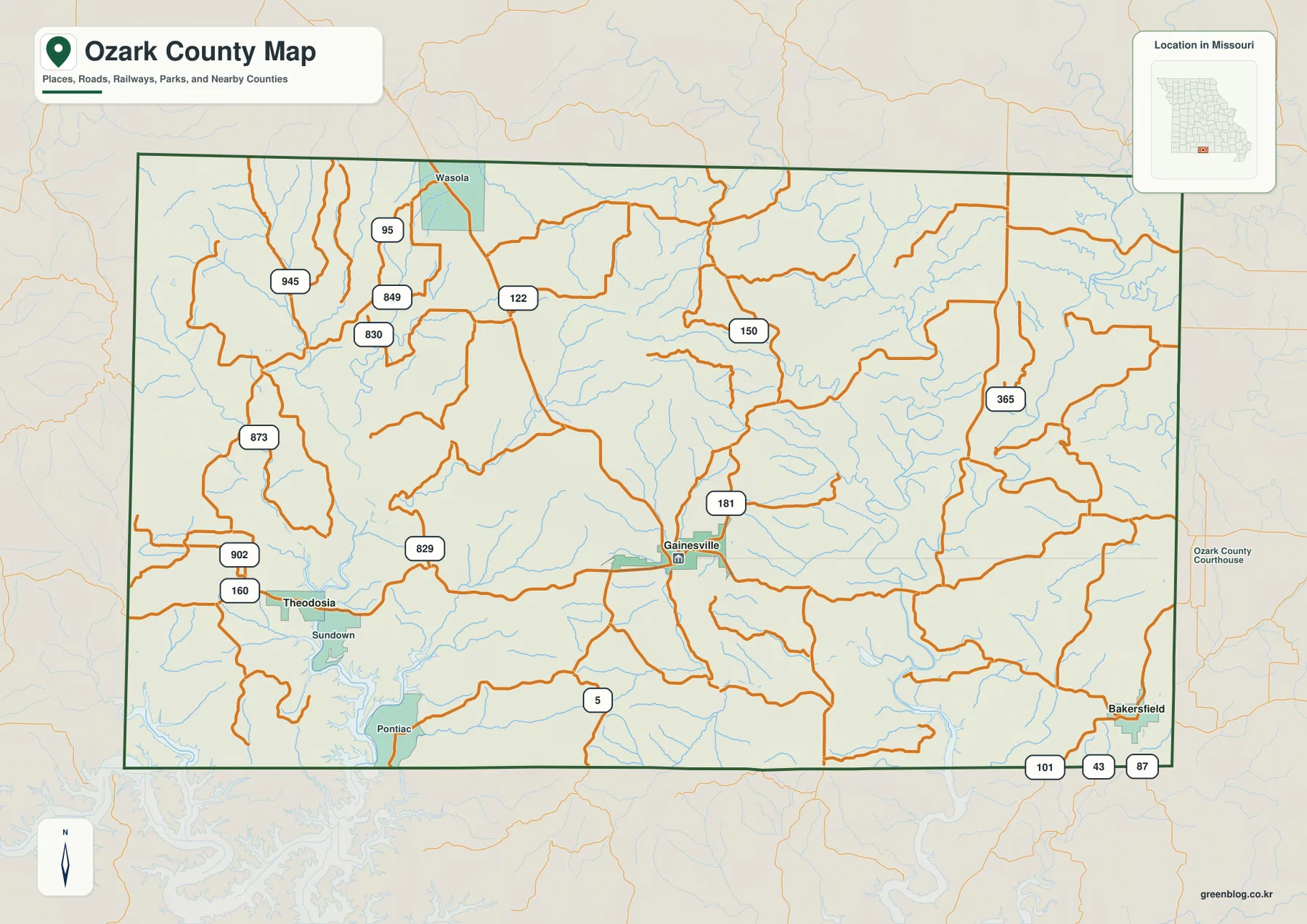
Gainesville sits slightly south of the county’s center and is the most useful place to begin reading the general map. Route 181 runs north from the area, Route 5 heads south toward the Arkansas line, and Route 160 provides the clearest westward connection toward Theodosia. Once those three directions are established, the many smaller numbered roads are easier to place.
Theodosia occupies the southwest near Bull Shoals Lake, with Route 160 and Route 902 providing clear local references. Pontiac lies farther south and closer to the deeply indented reservoir shoreline. Route 829 appears between the Theodosia side and Gainesville, crossing terrain where roads frequently bend around ridges and creek valleys rather than following long straight lines.
Wasola provides a useful northwest reference, with routes 95, 945, 849, and 830 labeled nearby. Routes 122 and 150 cross higher ground farther east, while the Bakersfield side shows 101, 43, and 87 close to the southeastern edge. The density of local route numbers makes the county look complicated, but the pattern becomes manageable when Gainesville, Theodosia, Bakersfield, and Wasola are used as anchors.
The county boundary itself is comparatively simple in many places, yet the roads inside it are strongly influenced by relief. Reservoir arms, narrow creek bottoms, and steep hills cause repeated bends, especially in the south and east. The map is therefore useful for regional orientation, while current turn-by-turn travel should rely on up-to-date road information.
Theodosia and Bakersfield frame Gainesville from opposite sides
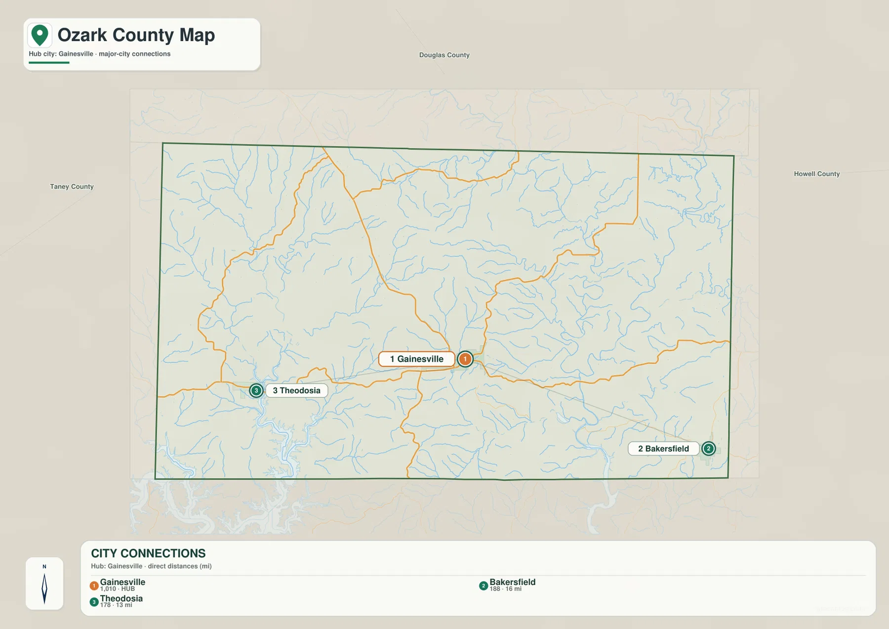
The city-connections map uses Gainesville as its hub and highlights Theodosia and Bakersfield. Theodosia is shown about 13 miles west of Gainesville in straight-line distance, while Bakersfield is about 16 miles to the southeast. Those figures measure point-to-point distance rather than driving mileage, so road travel is longer and follows a more winding path.
The three places form a useful geographic framework for the southern half of the county. Gainesville sits in the interior, Theodosia represents the Bull Shoals Lake side, and Bakersfield marks the North Fork River and Norfork Lake side. Their positions make it easier to understand why the county’s roads and drainage systems split toward different reservoir basins.
The map also displays index numbers beside the three communities, but the clearly defined field is the direct distance from Gainesville. Those unlabeled values should not be treated as population or another statistic without an explicit definition. For this article, the city map is used only for location, hub status, and the stated straight-line distances.
Wasola and Pontiac are not emphasized on the city-connections view, yet they remain important on the general map. Adding those two places to the Gainesville-Theodosia-Bakersfield triangle expands the mental picture to the northwest and the Bull Shoals shoreline, giving a better sense of the county’s full extent.
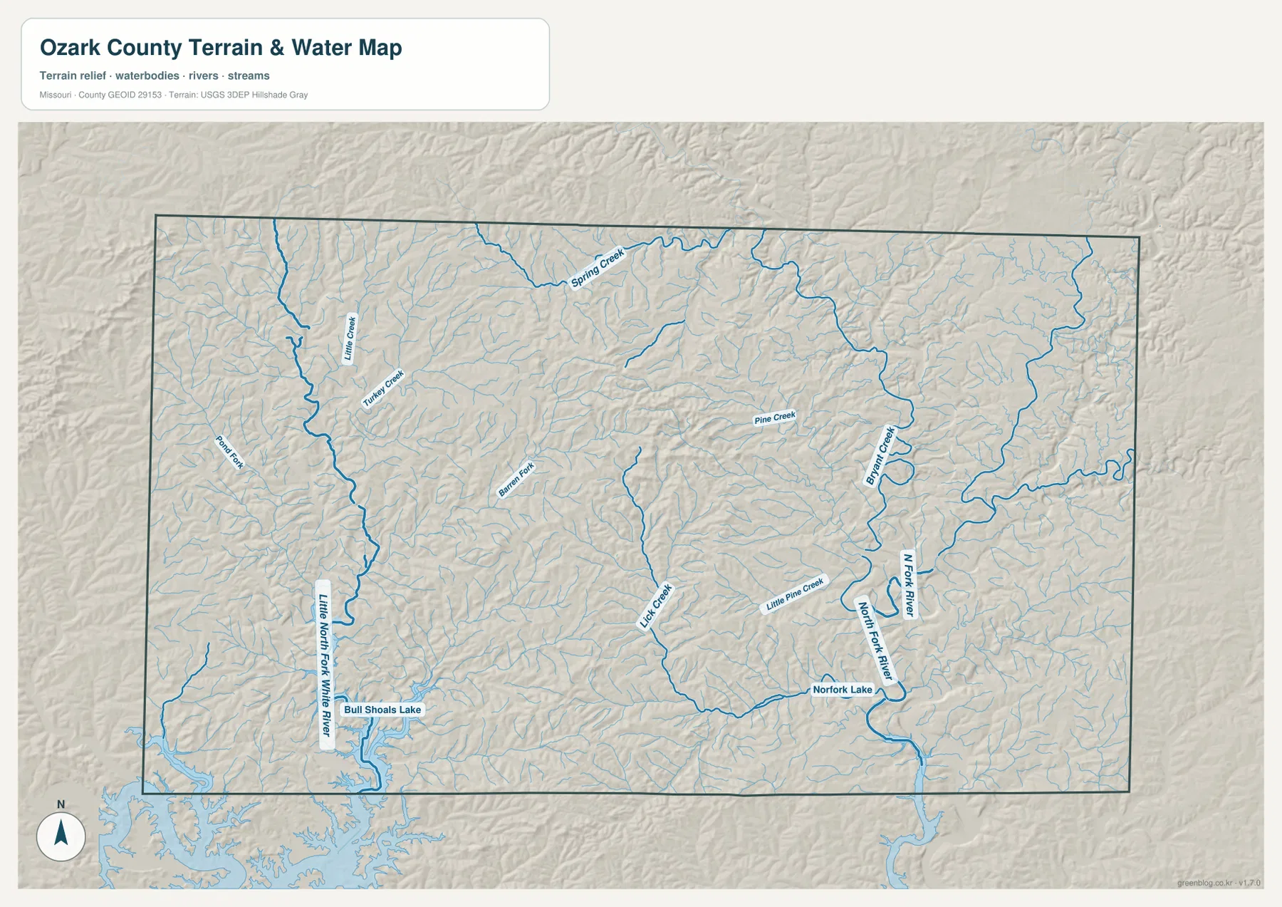
Bull Shoals and Norfork reservoir arms reach deep into creek-cut hills
Bull Shoals Lake is the dominant water feature in the southwest. Its branching shoreline reaches into former valleys, and the Little North Fork White River descends toward the reservoir from the north. The result is a maze of narrow low corridors around Theodosia and Pontiac, separated by ridges that stand well above the water.
Norfork Lake occupies the opposite side of the southern county. The North Fork River flows down from the north and joins the reservoir system, while Bryant Creek forms another major valley in the northeast. Pine Creek and Little Pine Creek cut through higher terrain farther west of the North Fork, giving the eastern half a strongly dissected appearance.
Smaller waterways fill the interior. Lick Creek, Barnes Fork, Spring Creek, Little Creek, and Turkey Creek occupy narrow valleys that repeat across the map. Individually they are much smaller than the major river systems, but together they explain why the landscape is so irregular and why few roads can follow a simple grid.
The terrain-and-water map is a geographic reference rather than a flood, depth, navigation, parcel, or reservoir-operations product. Water levels and flood conditions can change, and mapped water lines do not establish legal boundaries. Current operational or safety decisions should be based on the appropriate official source.
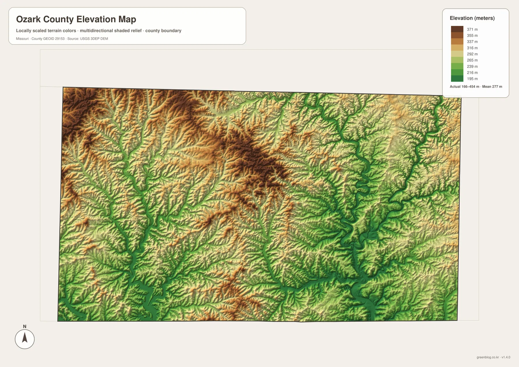
Relief ranges from about 166 to 454 meters
The elevation map reports an actual range of roughly 166 to 454 meters and a mean near 277 meters. The highest browns cover broad parts of the northwest and north-central interior, but deep green creek valleys cut through those uplands. The short distance between ridge tops and valley floors is one of the most obvious features of the county’s relief.
Lower terrain becomes more extensive around the North Fork River and Norfork Lake in the southeast. Bryant Creek also creates a prominent green corridor through the eastern hills. Around Bull Shoals Lake, low reservoir arms penetrate far into higher ground, so the shoreline is surrounded by repeated transitions from low valley floor to steep ridge.
The central county is not a single plateau sloping in one direction. Instead, ridges and narrow hollows alternate repeatedly, with Lick Creek, Pine Creek, and other tributaries occupying lower bands. Comparing the water map with the elevation colors makes those relationships easy to see because most named streams follow the same green corridors.
This county-scale elevation surface is appropriate for broad relief comparison, not for engineering, drainage design, construction, parcel-level elevation work, or survey-grade measurement. Site-specific decisions require more detailed official elevation data or field surveying.
Use the road map for orientation and the terrain maps for the county’s steep relief
For roads and place names, begin with Gainesville and then locate Theodosia to the west and Bakersfield to the southeast. Route 160 provides the clearest western connection, while Route 5 and Route 181 help organize the north-south directions around Gainesville. Adding Wasola and Pontiac from the general map gives a broader view of the northwest and southwest.
For water and terrain, Bull Shoals Lake and Norfork Lake are the easiest starting points. Follow the Little North Fork White River toward the southwest reservoir and the North Fork River toward Norfork Lake, then add Bryant Creek and the smaller interior tributaries. This sequence makes the county’s separate drainage corridors much easier to understand.
The elevation map explains why the road and water patterns are so irregular. High ridges north of Gainesville, low reservoir arms in the south, and the North Fork River valley in the east all fit together once the elevation colors are compared with the named waterways. The actual 166-to-454-meter range also shows that local relief is substantial even within a single county.
The downloadable JPG originals contain more pixels than the WebP previews on the page, making them better for enlargement, A3 printing, classroom handouts, reports, and personal reference. They remain general-purpose maps, however. Legal boundaries, property ownership, live road restrictions, flood status, reservoir conditions, and precise site elevations should always be checked against the appropriate current official source.
Frequently Asked Questions
How far are Theodosia and Bakersfield from Gainesville on the city map?
The map shows straight-line distances of about 13 miles from Gainesville to Theodosia and about 16 miles to Bakersfield. These are direct point-to-point distances rather than driving mileage, so real road trips are longer.
How much elevation change is shown across Ozark County?
The elevation map shows an actual range of about 166 to 454 meters with a mean near 277 meters. High ridges cover much of the northwest and central interior, while reservoir arms and major river valleys are substantially lower.
Which waterways are the best starting points on the terrain map?
Start with Bull Shoals Lake in the southwest and Norfork Lake in the southeast. The Little North Fork White River, North Fork River, and Bryant Creek then provide clear references for the major valley systems between them.
Map File Information
The download ZIP contains high-resolution JPG versions of the Ozark County general map, city map, terrain-and-water map, and elevation map.
- File Type: JPG
Related Maps
Sources and References
Boundary and road reference data are supported by U.S. Census Bureau TIGER/Line, water features by USGS National Hydrography, and elevation data by the USGS 3D Elevation Program. These maps are general geographic references and are not substitutes for legal surveys or current operational data.
Green Map creates custom-edited map images using open geographic data sources such as geoBoundaries, Natural Earth, OpenStreetMap, and government open data. These maps are edited visual materials, not raw data files, and are provided for education, documents, presentations, and graphic reference.